The B65 8 postcode sector is within the county of West Midlands.
Did you know? According to the 2021 Census, the B65 8 postcode sector is home to a bustling 8,476 residents!
Given that each sector allows for 400 unique postcode combinations. Letters C, I, K, M, O and V are not allowed in the last two letters of a postcode. With 165 postcodes already in use, this leaves 235 units available.
The B65 8 postal code covers the settlement of ROWLEY REGIS.
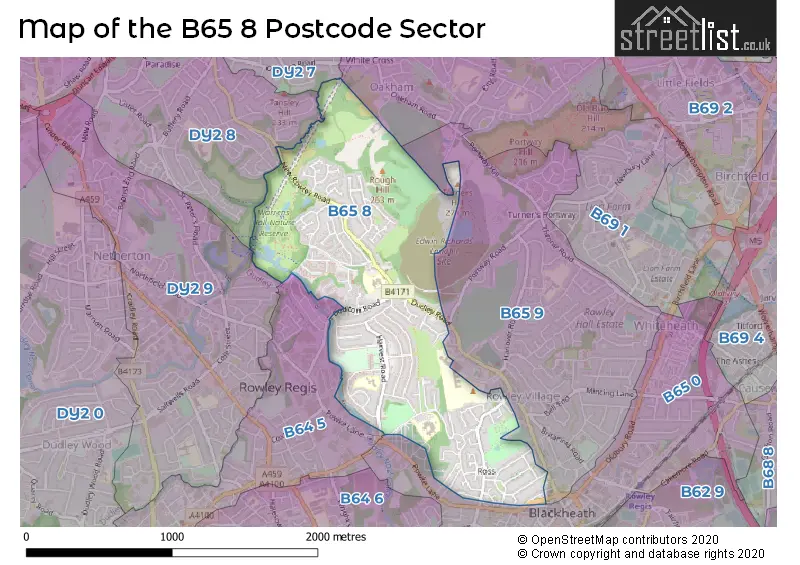
The B65 8 Postcode shares a border with B64 5 (CRADLEY HEATH), DY2 7 (DUDLEY), DY2 8 (DUDLEY), DY2 9 (DUDLEY, Netherton), B65 0 (ROWLEY REGIS), B65 9 (ROWLEY REGIS) and B69 1 (Tividale, OLDBURY).
The sector is within the post town of ROWLEY REGIS.
B65 8 is a postcode sector within the B65 postcode district which is within the B Birmingham postcode area.
The Royal Mail delivery office for the B65 8 postal sector is the Coombs Wood Delivery Office.
The area of the B65 8 postcode sector is 0.99 square miles which is 2.57 square kilometres or 636.26 square acres.
Waterways within the B65 8 postcode sector include the Dudley No.2 Canal, Netherton Tunnel; Dudley No.2 Canal, Netherton Tunnel Branch (BCN).

Map of the B65 8 Postcode Sector
Explore the B65 8 postcode sector by using our free interactive map.
| B | 6 | 5 | - | 8 | X | X |
| B | 6 | 5 | Space | 8 | Letter | Letter |
Official List of Streets
ROWLEY REGIS (94 Streets)
Unofficial Streets or Alternative Spellings
Weather Forecast for B65 8
Press Button to Show Forecast for Springfield
| Time Period | Icon | Description | Temperature | Rain Probability | Wind |
|---|---|---|---|---|---|
| 06:00 to 09:00 | Cloudy | 6.0°C (feels like 3.0°C) | 4.00% | NE 7 mph | |
| 09:00 to 12:00 | Cloudy | 6.0°C (feels like 4.0°C) | 4.00% | NNE 7 mph | |
| 12:00 to 15:00 | Partly cloudy (day) | 9.0°C (feels like 8.0°C) | 1.00% | N 9 mph | |
| 15:00 to 18:00 | Sunny day | 11.0°C (feels like 9.0°C) | 1.00% | NNW 9 mph | |
| 18:00 to 21:00 | Sunny day | 10.0°C (feels like 8.0°C) | 0.00% | NNW 7 mph | |
| 21:00 to 00:00 | Clear night | 6.0°C (feels like 4.0°C) | 1.00% | NNW 7 mph |
Press Button to Show Forecast for Springfield
| Time Period | Icon | Description | Temperature | Rain Probability | Wind |
|---|---|---|---|---|---|
| 00:00 to 03:00 | Partly cloudy (night) | 4.0°C (feels like 2.0°C) | 1.00% | NW 7 mph | |
| 03:00 to 06:00 | Cloudy | 3.0°C (feels like 0.0°C) | 4.00% | W 7 mph | |
| 06:00 to 09:00 | Cloudy | 4.0°C (feels like 1.0°C) | 5.00% | W 7 mph | |
| 09:00 to 12:00 | Overcast | 6.0°C (feels like 4.0°C) | 10.00% | WNW 9 mph | |
| 12:00 to 15:00 | Overcast | 9.0°C (feels like 7.0°C) | 12.00% | NW 9 mph | |
| 15:00 to 18:00 | Cloudy | 9.0°C (feels like 7.0°C) | 9.00% | NW 9 mph | |
| 18:00 to 21:00 | Cloudy | 9.0°C (feels like 7.0°C) | 6.00% | NNW 7 mph | |
| 21:00 to 00:00 | Cloudy | 6.0°C (feels like 4.0°C) | 5.00% | NNE 7 mph |
Press Button to Show Forecast for Springfield
| Time Period | Icon | Description | Temperature | Rain Probability | Wind |
|---|---|---|---|---|---|
| 00:00 to 03:00 | Cloudy | 5.0°C (feels like 3.0°C) | 7.00% | E 7 mph | |
| 03:00 to 06:00 | Cloudy | 4.0°C (feels like 1.0°C) | 12.00% | ESE 7 mph | |
| 06:00 to 09:00 | Cloudy | 4.0°C (feels like 1.0°C) | 15.00% | E 7 mph | |
| 09:00 to 12:00 | Cloudy | 6.0°C (feels like 3.0°C) | 15.00% | ESE 9 mph | |
| 12:00 to 15:00 | Overcast | 8.0°C (feels like 6.0°C) | 18.00% | ESE 9 mph | |
| 15:00 to 18:00 | Overcast | 9.0°C (feels like 7.0°C) | 20.00% | ESE 9 mph | |
| 18:00 to 21:00 | Overcast | 8.0°C (feels like 6.0°C) | 26.00% | ENE 9 mph | |
| 21:00 to 00:00 | Cloudy | 6.0°C (feels like 4.0°C) | 22.00% | NE 9 mph |
Press Button to Show Forecast for Springfield
| Time Period | Icon | Description | Temperature | Rain Probability | Wind |
|---|---|---|---|---|---|
| 00:00 to 03:00 | Cloudy | 5.0°C (feels like 2.0°C) | 20.00% | NE 9 mph | |
| 03:00 to 06:00 | Light rain | 5.0°C (feels like 2.0°C) | 51.00% | NE 9 mph | |
| 06:00 to 09:00 | Light rain | 5.0°C (feels like 2.0°C) | 48.00% | E 9 mph | |
| 09:00 to 12:00 | Overcast | 7.0°C (feels like 4.0°C) | 22.00% | ENE 9 mph | |
| 12:00 to 15:00 | Cloudy | 9.0°C (feels like 7.0°C) | 22.00% | E 9 mph | |
| 15:00 to 18:00 | Cloudy | 10.0°C (feels like 8.0°C) | 22.00% | NE 9 mph | |
| 18:00 to 21:00 | Light rain | 9.0°C (feels like 7.0°C) | 52.00% | NNE 9 mph | |
| 21:00 to 00:00 | Light rain | 8.0°C (feels like 5.0°C) | 51.00% | NNE 9 mph |
Schools and Places of Education Within the B65 8 Postcode Sector
Brickhouse Primary School
Foundation school
Dudhill Road, Rowley Regis, West Midlands, B65 8HS
Head: Mr Paul Newby
Ofsted Rating: Good
Inspection: 2023-01-11 (469 days ago)
Website: Visit Brickhouse Primary School Website
Phone: 01215591629
Number of Pupils: 232
Springfield Primary School
Foundation school
Dudley Road, Rowley Regis, West Midlands, B65 8JY
Head: Mrs Alison Bhardwaj
Ofsted Rating: Requires improvement
Inspection: 2021-11-04 (902 days ago)
Website: Visit Springfield Primary School Website
Phone: 01215591333
Number of Pupils: 459
House Prices in the B65 8 Postcode Sector
| Type of Property | 2018 Average | 2018 Sales | 2017 Average | 2017 Sales | 2016 Average | 2016 Sales | 2015 Average | 2015 Sales |
|---|---|---|---|---|---|---|---|---|
| Detached | £225,333 | 15 | £243,216 | 16 | £192,161 | 23 | £198,491 | 17 |
| Semi-Detached | £153,881 | 45 | £144,174 | 49 | £126,500 | 30 | £118,840 | 42 |
| Terraced | £141,484 | 29 | £139,980 | 32 | £114,691 | 23 | £104,324 | 33 |
| Flats | £103,931 | 8 | £92,583 | 6 | £81,900 | 20 | £105,930 | 10 |
Important Postcodes B65 8 in the Postcode Sector
B65 8DA is the postcode for Sandwell and West Birmingham Hospitals NHS Trust, Rowley Regis Hospital, and Sandwell and West Birmingham Hospitals NHS Trust, Rowley Regis Hospital, Moor Lane
B65 8EL is the postcode for Sandwell M B C, Harvest Road
B65 8HS is the postcode for Brickhouse Junior & Infant School, Dudhill Road, and Brickhouse Primary School, Dudhill Road
B65 8JY is the postcode for Springfield Primary School, Dudley Road
| The B65 8 Sector is within these Local Authorities |
|
|---|---|
| The B65 8 Sector is within these Counties |
|
| The B65 8 Sector is within these Water Company Areas |
|