The B7 4 postcode sector is within the county of West Midlands.
Did you know? According to the 2021 Census, the B7 4 postcode sector is home to a bustling 4,406 residents!
Given that each sector allows for 400 unique postcode combinations. Letters C, I, K, M, O and V are not allowed in the last two letters of a postcode. With 129 postcodes already in use, this leaves 271 units available.
The largest settlements in the B7 4 postal code are BIRMINGHAM and Nechells.
The B7 4 Postcode shares a border with B4 7 (BIRMINGHAM), B5 5 (BIRMINGHAM), B6 4 (BIRMINGHAM, Aston), B8 1 (BIRMINGHAM, Saltley, Washwood Heath), B9 4 (BIRMINGHAM, Bordesley, Bordesley Green) and B7 5 (BIRMINGHAM, Nechells).
The sector is within the post town of BIRMINGHAM.
B7 4 is a postcode sector within the B7 postcode district which is within the B Birmingham postcode area.
The Royal Mail delivery office for the B7 4 postal sector is the Aston Delivery Office.
The area of the B7 4 postcode sector is 0.61 square miles which is 1.57 square kilometres or 389.07 square acres.
Waterways within the B7 4 postcode sector include the Birmingham and Fazeley Canal, Digbeth Branch Canal.

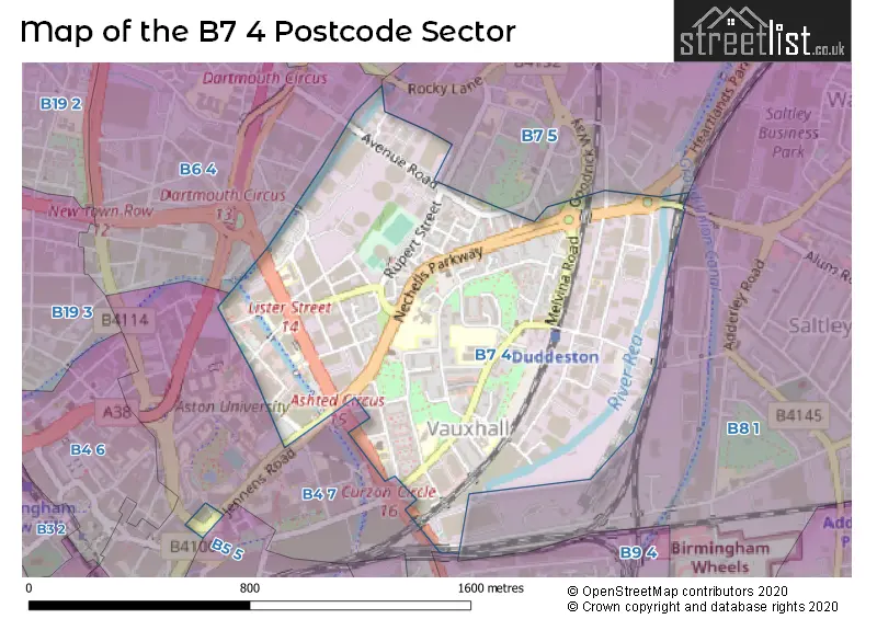
Map of the B7 4 Postcode Sector
Explore the B7 4 postcode sector by using our free interactive map.
| B | 7 | - | 4 | X | X |
| B | 7 | Space | 4 | Letter | Letter |
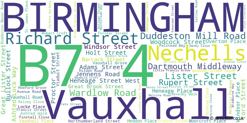
Official List of Streets
BIRMINGHAM (65 Streets)
Nechells (2 Streets)
Vauxhall (1 Streets)
Unofficial Streets or Alternative Spellings
BIRMINGHAM
ASTON ROAD ASTON STREET BLOOMSBURY STREET BLOOMSBURY WALK CATO STREET NORTH COLESHILL STREET CROMWELL STREET GOODRICK WAY HEARTLANDS PARKWAY LANDOR STREET LAWLEY MIDDLEWAY LINGARD CLOSE MOOR STREET QUEENSWAYAston
AVENUE ROAD ALDERFLAT PLACE ASHTED LOCK ASHTED ROW ENTERPRISE WAY HOLT COURT JAMES WATT QUEENSWAY KELLET ROAD LAWFORD CLOSE LOVE LANE NEWHAVEN CLOSE PARK STREET PITNEY STREET SALTLEY VIADUCT VENTURE WAYSaltley
DUDDESTON MILL ROADWeather Forecast for B7 4
Press Button to Show Forecast for Vauxhall
| Time Period | Icon | Description | Temperature | Rain Probability | Wind |
|---|---|---|---|---|---|
| 21:00 to 00:00 | Clear night | 7.0°C (feels like 4.0°C) | 3.00% | NW 9 mph |
Press Button to Show Forecast for Vauxhall
| Time Period | Icon | Description | Temperature | Rain Probability | Wind |
|---|---|---|---|---|---|
| 00:00 to 03:00 | Partly cloudy (night) | 5.0°C (feels like 2.0°C) | 11.00% | NW 9 mph | |
| 03:00 to 06:00 | Cloudy | 5.0°C (feels like 1.0°C) | 11.00% | WNW 11 mph | |
| 06:00 to 09:00 | Sunny day | 4.0°C (feels like 1.0°C) | 3.00% | NW 9 mph | |
| 09:00 to 12:00 | Partly cloudy (day) | 7.0°C (feels like 3.0°C) | 3.00% | NW 13 mph | |
| 12:00 to 15:00 | Cloudy | 10.0°C (feels like 7.0°C) | 6.00% | NW 16 mph | |
| 15:00 to 18:00 | Cloudy | 10.0°C (feels like 7.0°C) | 10.00% | NW 13 mph | |
| 18:00 to 21:00 | Cloudy | 9.0°C (feels like 6.0°C) | 10.00% | NW 11 mph | |
| 21:00 to 00:00 | Cloudy | 6.0°C (feels like 4.0°C) | 33.00% | NNW 9 mph |
Press Button to Show Forecast for Vauxhall
| Time Period | Icon | Description | Temperature | Rain Probability | Wind |
|---|---|---|---|---|---|
| 00:00 to 03:00 | Clear night | 5.0°C (feels like 2.0°C) | 1.00% | N 7 mph | |
| 03:00 to 06:00 | Clear night | 3.0°C (feels like 1.0°C) | 2.00% | NNW 4 mph | |
| 06:00 to 09:00 | Partly cloudy (day) | 3.0°C (feels like 1.0°C) | 6.00% | NW 4 mph | |
| 09:00 to 12:00 | Partly cloudy (day) | 7.0°C (feels like 6.0°C) | 4.00% | WNW 4 mph | |
| 12:00 to 15:00 | Overcast | 10.0°C (feels like 9.0°C) | 8.00% | W 7 mph | |
| 15:00 to 18:00 | Overcast | 12.0°C (feels like 10.0°C) | 14.00% | W 9 mph | |
| 18:00 to 21:00 | Cloudy | 11.0°C (feels like 8.0°C) | 15.00% | W 11 mph | |
| 21:00 to 00:00 | Cloudy | 9.0°C (feels like 6.0°C) | 18.00% | W 11 mph |
Press Button to Show Forecast for Vauxhall
| Time Period | Icon | Description | Temperature | Rain Probability | Wind |
|---|---|---|---|---|---|
| 00:00 to 03:00 | Cloudy | 8.0°C (feels like 5.0°C) | 17.00% | W 11 mph | |
| 03:00 to 06:00 | Overcast | 8.0°C (feels like 5.0°C) | 12.00% | WNW 11 mph | |
| 06:00 to 09:00 | Overcast | 8.0°C (feels like 5.0°C) | 9.00% | WNW 11 mph | |
| 09:00 to 12:00 | Overcast | 10.0°C (feels like 6.0°C) | 9.00% | NW 16 mph | |
| 12:00 to 15:00 | Cloudy | 11.0°C (feels like 8.0°C) | 7.00% | NW 16 mph | |
| 15:00 to 18:00 | Cloudy | 12.0°C (feels like 9.0°C) | 5.00% | NNW 16 mph | |
| 18:00 to 21:00 | Cloudy | 11.0°C (feels like 8.0°C) | 5.00% | NNW 13 mph | |
| 21:00 to 00:00 | Partly cloudy (night) | 9.0°C (feels like 6.0°C) | 3.00% | NNW 9 mph |
Press Button to Show Forecast for Vauxhall
| Time Period | Icon | Description | Temperature | Rain Probability | Wind |
|---|---|---|---|---|---|
| 00:00 to 03:00 | Partly cloudy (night) | 7.0°C (feels like 5.0°C) | 4.00% | N 7 mph | |
| 03:00 to 06:00 | Partly cloudy (night) | 6.0°C (feels like 4.0°C) | 2.00% | N 7 mph | |
| 06:00 to 09:00 | Sunny day | 5.0°C (feels like 3.0°C) | 1.00% | N 7 mph | |
| 09:00 to 12:00 | Partly cloudy (day) | 8.0°C (feels like 6.0°C) | 1.00% | N 7 mph | |
| 12:00 to 15:00 | Partly cloudy (day) | 11.0°C (feels like 9.0°C) | 1.00% | N 7 mph | |
| 15:00 to 18:00 | Cloudy | 12.0°C (feels like 11.0°C) | 5.00% | N 7 mph | |
| 18:00 to 21:00 | Partly cloudy (day) | 12.0°C (feels like 11.0°C) | 1.00% | N 7 mph | |
| 21:00 to 00:00 | Clear night | 10.0°C (feels like 8.0°C) | 1.00% | NNW 7 mph |
Schools and Places of Education Within the B7 4 Postcode Sector
Aston University Engineering Academy
University technical college
1 Lister Street, Birmingham, West Midlands, B7 4AG
Head: Mr Daniel Locke-Wheaton
Ofsted Rating: Good
Inspection: 2022-01-13 (824 days ago)
Website: Visit Aston University Engineering Academy Website
Phone: 01213800570
Number of Pupils: 743
Heartlands Academy
Academy sponsor led
Great Francis Street, Birmingham, West Midlands, B7 4QR
Head: Mrs Sophia Haughton
Ofsted Rating: Outstanding
Inspection: 2014-02-06 (3722 days ago)
Website: Visit Heartlands Academy Website
Phone: 01214643931
Number of Pupils: 799
St Matthew's CofE Primary School
Voluntary controlled school
Duddeston Manor Road, Birmingham, West Midlands, B7 4JR
Head: Miss Sonia Thompson
Ofsted Rating: Outstanding
Inspection: 2015-02-06 (3357 days ago)
Website: Visit St Matthew's CofE Primary School Website
Phone: 01213591602
Number of Pupils: 205
St Vincent's Catholic Primary School
Voluntary aided school
Vauxhall Grove, BIRMINGHAM, West Midlands, B7 4HP
Head: Mrs Tarah O'Brien
Ofsted Rating: Good
Inspection: 2023-11-22 (146 days ago)
Website: Visit St Vincent's Catholic Primary School Website
Phone: 01216752359
Number of Pupils: 232
House Prices in the B7 4 Postcode Sector
| Type of Property | 2018 Average | 2018 Sales | 2017 Average | 2017 Sales | 2016 Average | 2016 Sales | 2015 Average | 2015 Sales |
|---|---|---|---|---|---|---|---|---|
| Detached | £200,000 | 1 | £0 | 0 | £0 | 0 | £0 | 0 |
| Semi-Detached | £180,000 | 1 | £0 | 0 | £144,500 | 2 | £110,580 | 1 |
| Terraced | £139,400 | 4 | £0 | 0 | £116,000 | 1 | £0 | 0 |
| Flats | £0 | 0 | £79,000 | 3 | £97,500 | 3 | £63,250 | 2 |
Important Postcodes B7 4 in the Postcode Sector
B7 4AA is the postcode for King Solomon International Business School, Main Building, Richard Street, 5TH FLOOR, Birmingham Community Healthcare Trust, Waterlinks House, FLOORS 2, 3 AND 4, Eastern Birmingham P C T, Waterlinks House, Richard Street, King Solomon International Business School, Sports Hall, Richard Street, and 5TH FLOOR, South Birmingham P C T, Waterlinks House, Richard Street
B7 4AG is the postcode for National College for High Speed Rail, 2 Lister Street, and Aston University Engineering Academy, 1 Lister Street
B7 4BL is the postcode for 10 Woodcock Street, Aston University Nursery And Pre School, 1 Woodcock Street, and Birmingham City Council, 10 Woodcock Street
B7 4BN is the postcode for Advantage West Midlands, Unit 3 Priestley Wharf, 20 Holt Street
B7 4HA is the postcode for Specialist Support Service, Vauxhall Gardens, Barrack Street
B7 4HP is the postcode for St Vincent Catholic Primary School, Vauxhall Grove
B7 4HW is the postcode for 99 Vauxhall Road, West Midlands Fire Service, Safeside, 101 Vauxhall Road, West Midlands Fire Service, Headquarters, 99 Vauxhall Road, and West Midlands Fire Service, 101 Vauxhall Road
B7 4JN is the postcode for St Matthews Centre, 11 Hobart Croft
B7 4JR is the postcode for St. Matthews C of E Junior & Infant School, Duddeston Manor Road, and St. Matthews Primary School, Duddeston Manor Road
B7 4QR is the postcode for Heartlands Academy, Great Francis Street
B7 4QU is the postcode for Nechells Green Community Centre, Melvina Road
B7 4RQ is the postcode for Birmingham City Council, 25 Dollman Street
B7 4SB is the postcode for Heartlands Resource Centre, 6 Inkerman Street, and Birmingham City Council, Employment Preparation Unit, 6 Inkerman Street
B7 4SL is the postcode for Unit 12-15, Devon Street
B7 4SN is the postcode for The Receipt & Distribution Centre, Unit 16, Mainstream Industrial Park, Mainstream Way
| The B7 4 Sector is within these Local Authorities |
|
|---|---|
| The B7 4 Sector is within these Counties |
|
| The B7 4 Sector is within these Water Company Areas |
|