The B71 2 postcode sector is within the county of West Midlands.
Did you know? According to the 2021 Census, the B71 2 postcode sector is home to a bustling 10,616 residents!
Given that each sector allows for 400 unique postcode combinations. Letters C, I, K, M, O and V are not allowed in the last two letters of a postcode. With 192 postcodes already in use, this leaves 208 units available.
The B71 2 postal code covers the settlement of WEST BROMWICH.
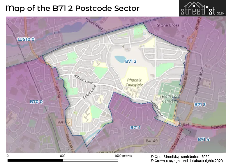
The B71 2 Postcode shares a border with B71 3 (WEST BROMWICH), WS10 0 (WEDNESBURY), B70 0 (WEST BROMWICH, Hill Top, Golds Hill) and B71 1 (WEST BROMWICH).
The sector is within the post town of WEST BROMWICH.
B71 2 is a postcode sector within the B71 postcode district which is within the B Birmingham postcode area.
The Royal Mail delivery office for the B71 2 postal sector is the West Bromwich Delivery Office.
The area of the B71 2 postcode sector is 0.82 square miles which is 2.12 square kilometres or 523.22 square acres.

Map of the B71 2 Postcode Sector
Explore the B71 2 postcode sector by using our free interactive map.
| B | 7 | 1 | - | 2 | X | X |
| B | 7 | 1 | Space | 2 | Letter | Letter |
Official List of Streets
WEST BROMWICH (77 Streets)
Unofficial Streets or Alternative Spellings
Weather Forecast for B71 2
Press Button to Show Forecast for Hill Top
| Time Period | Icon | Description | Temperature | Rain Probability | Wind |
|---|---|---|---|---|---|
| 03:00 to 06:00 | Cloudy | 5.0°C (feels like 3.0°C) | 3.00% | N 4 mph | |
| 06:00 to 09:00 | Partly cloudy (day) | 5.0°C (feels like 3.0°C) | 1.00% | NNW 4 mph | |
| 09:00 to 12:00 | Cloudy | 7.0°C (feels like 5.0°C) | 4.00% | N 4 mph | |
| 12:00 to 15:00 | Cloudy | 10.0°C (feels like 8.0°C) | 5.00% | NNW 9 mph | |
| 15:00 to 18:00 | Overcast | 11.0°C (feels like 9.0°C) | 8.00% | N 7 mph | |
| 18:00 to 21:00 | Overcast | 10.0°C (feels like 9.0°C) | 8.00% | NNE 7 mph | |
| 21:00 to 00:00 | Cloudy | 8.0°C (feels like 7.0°C) | 5.00% | NE 4 mph |
Press Button to Show Forecast for Hill Top
| Time Period | Icon | Description | Temperature | Rain Probability | Wind |
|---|---|---|---|---|---|
| 00:00 to 03:00 | Cloudy | 7.0°C (feels like 5.0°C) | 4.00% | NNE 4 mph | |
| 03:00 to 06:00 | Overcast | 6.0°C (feels like 4.0°C) | 7.00% | ENE 4 mph | |
| 06:00 to 09:00 | Overcast | 5.0°C (feels like 4.0°C) | 9.00% | NNE 4 mph | |
| 09:00 to 12:00 | Overcast | 7.0°C (feels like 5.0°C) | 9.00% | NNE 7 mph | |
| 12:00 to 15:00 | Cloudy | 9.0°C (feels like 7.0°C) | 9.00% | NE 9 mph | |
| 15:00 to 18:00 | Overcast | 10.0°C (feels like 8.0°C) | 13.00% | NE 9 mph | |
| 18:00 to 21:00 | Cloudy | 9.0°C (feels like 7.0°C) | 8.00% | NE 7 mph | |
| 21:00 to 00:00 | Cloudy | 7.0°C (feels like 5.0°C) | 7.00% | ENE 7 mph |
Press Button to Show Forecast for Hill Top
| Time Period | Icon | Description | Temperature | Rain Probability | Wind |
|---|---|---|---|---|---|
| 00:00 to 03:00 | Cloudy | 5.0°C (feels like 3.0°C) | 7.00% | ENE 4 mph | |
| 03:00 to 06:00 | Cloudy | 4.0°C (feels like 3.0°C) | 8.00% | ENE 2 mph | |
| 06:00 to 09:00 | Overcast | 4.0°C (feels like 3.0°C) | 14.00% | NE 4 mph | |
| 09:00 to 12:00 | Cloudy | 7.0°C (feels like 5.0°C) | 14.00% | ESE 4 mph | |
| 12:00 to 15:00 | Light rain | 8.0°C (feels like 6.0°C) | 44.00% | SE 7 mph | |
| 15:00 to 18:00 | Light rain | 9.0°C (feels like 7.0°C) | 43.00% | ESE 7 mph | |
| 18:00 to 21:00 | Overcast | 9.0°C (feels like 7.0°C) | 17.00% | ESE 7 mph | |
| 21:00 to 00:00 | Cloudy | 7.0°C (feels like 6.0°C) | 16.00% | ENE 4 mph |
Press Button to Show Forecast for Hill Top
| Time Period | Icon | Description | Temperature | Rain Probability | Wind |
|---|---|---|---|---|---|
| 00:00 to 03:00 | Cloudy | 7.0°C (feels like 5.0°C) | 9.00% | ENE 4 mph | |
| 03:00 to 06:00 | Overcast | 6.0°C (feels like 5.0°C) | 10.00% | NNE 4 mph | |
| 06:00 to 09:00 | Overcast | 6.0°C (feels like 4.0°C) | 9.00% | NNE 4 mph | |
| 09:00 to 12:00 | Cloudy | 8.0°C (feels like 6.0°C) | 7.00% | NE 7 mph | |
| 12:00 to 15:00 | Cloudy | 10.0°C (feels like 9.0°C) | 10.00% | NE 9 mph | |
| 15:00 to 18:00 | Cloudy | 12.0°C (feels like 10.0°C) | 16.00% | NE 9 mph | |
| 18:00 to 21:00 | Overcast | 11.0°C (feels like 9.0°C) | 17.00% | NE 9 mph | |
| 21:00 to 00:00 | Partly cloudy (night) | 8.0°C (feels like 6.0°C) | 3.00% | NE 7 mph |
Schools and Places of Education Within the B71 2 Postcode Sector
Hall Green Primary School
Community school
Westminster Road, West Bromwich, West Midlands, B71 2JQ
Head: Mrs Alison Gilbert
Ofsted Rating: Good
Inspection: 2023-03-23 (394 days ago)
Website: Visit Hall Green Primary School Website
Phone: 01215882080
Number of Pupils: 457
Moorlands Primary School
Foundation school
Winchester Road, West Bromwich, West Midlands, B71 2NZ
Head: Mrs Katherine Roberts
Ofsted Rating: Good
Inspection: 2022-06-29 (661 days ago)
Website: Visit Moorlands Primary School Website
Phone: 01215560352
Number of Pupils: 206
Sandwell Community School
Pupil referral unit
Westminster Road, West Bromwich, West Midlands, B71 2JN
Head: Mr Kevin Morgan
Ofsted Rating: Good
Inspection: 2018-10-16 (2013 days ago)
Website: Visit Sandwell Community School Website
Phone: 01215335802
Number of Pupils: 66
The Phoenix Collegiate
Foundation school
Clarkes Lane, West Bromwich, West Midlands, B71 2BX
Head: Mr Michael Smith
Ofsted Rating: Good
Inspection: 2023-02-15 (430 days ago)
Website: Visit The Phoenix Collegiate Website
Phone: 01215888384
Number of Pupils: 1917
House Prices in the B71 2 Postcode Sector
| Type of Property | 2018 Average | 2018 Sales | 2017 Average | 2017 Sales | 2016 Average | 2016 Sales | 2015 Average | 2015 Sales |
|---|---|---|---|---|---|---|---|---|
| Detached | £220,000 | 10 | £157,500 | 1 | £200,375 | 4 | £156,886 | 7 |
| Semi-Detached | £139,701 | 77 | £130,548 | 61 | £123,708 | 53 | £117,963 | 59 |
| Terraced | £139,674 | 23 | £125,581 | 18 | £117,302 | 19 | £99,750 | 26 |
| Flats | £59,000 | 1 | £61,000 | 1 | £0 | 0 | £80,500 | 2 |
Important Postcodes B71 2 in the Postcode Sector
B71 2BG is the postcode for Sandwell Mental Health NHS and Social Care Trust, Heath Lane Hospital, and Gerry Simon Unit and Macarthur Centre, Heath Lane Hospital
B71 2BX is the postcode for BLOCK L, Phoenix Collegiate, Clarkes Lane, BLOCK C, Phoenix Collegiate, Clarkes Lane, BLOCK J, Phoenix Collegiate, Clarkes Lane, TEACHING BLOCK, Phoenix Collegiate, Clarkes Lane, Phoenix Collegiate, Clarkes Lane, BLOCK M, Phoenix Collegiate, Clarkes Lane, BLOCK K, Phoenix Collegiate, Clarkes Lane, BLOCK A, Phoenix Collegiate, Clarkes Lane, BLOCK F, Phoenix Collegiate, Clarkes Lane, BLOCK B, Phoenix Collegiate, Clarkes Lane, BLOCK H, Phoenix Collegiate, Clarkes Lane, SIXTH FORM, Phoenix Collegiate, Clarkes Lane, BLOCK E, Phoenix Collegiate, Clarkes Lane, BLOCK D, Phoenix Collegiate, Clarkes Lane, CLC BLOCK, Phoenix Collegiate, Clarkes Lane, BLOCK I, Phoenix Collegiate, Clarkes Lane, and SPORTS HALL, Phoenix Collegiate, Clarkes Lane
B71 2EA is the postcode for Manor House, Hall Green Road
B71 2JN is the postcode for The Westminster School, Westminster Road, Sandwell Community School, Westminster Road, BRIDGE CENTRE, SANDWELL COMMUNITY SCHOOL, WESTMINSTER ROAD, The Bridge Centre, Westminster Road, and Sandwell Community School, The Bridge Centre, Westminster Road
B71 2JQ is the postcode for Hall Green Primary & Infant School, Westminster Road, and Hall Green Primary School, Westminster Road
B71 2NZ is the postcode for MOORLANDS PRIMARY SCHOOL, WINCHESTER ROAD, WEST BROMWICH, and Moorlands Primary School, Winchester Road
B71 2RP is the postcode for F E T C Education Training Centre, Huntingdon Road, Hateley Heath Junior & Infant School, Huntingdon Road, and Hateley Heath Academy, Huntingdon Road
B71 2ST is the postcode for St John Bosco Roman Catholic Primary School, Monmouth Drive, and St. John Bosco RC Primary School, Monmouth Drive
| The B71 2 Sector is within these Local Authorities |
|
|---|---|
| The B71 2 Sector is within these Counties |
|
| The B71 2 Sector is within these Water Company Areas |
|