The B71 4 postcode sector is within the county of West Midlands.
Did you know? According to the 2021 Census, the B71 4 postcode sector is home to a bustling 4,085 residents!
Given that each sector allows for 400 unique postcode combinations. Letters C, I, K, M, O and V are not allowed in the last two letters of a postcode. With 108 postcodes already in use, this leaves 292 units available.
The largest settlements in the B71 4 postal code are WEST BROMWICH and Sandwell.
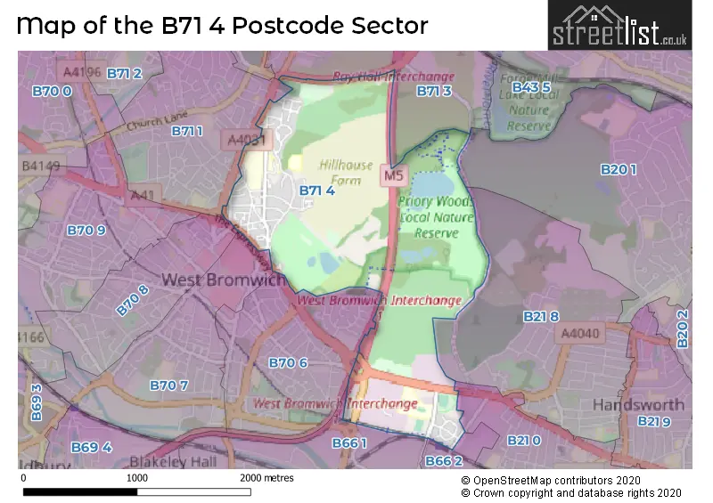
The B71 4 Postcode shares a border with B20 1 (BIRMINGHAM), B70 8 (WEST BROMWICH), B71 3 (WEST BROMWICH), B70 7 (WEST BROMWICH, Lyng), B21 0 (BIRMINGHAM, Handsworth), B21 8 (BIRMINGHAM, Handsworth), B66 1 (SMETHWICK), B66 2 (SMETHWICK, Middlemore Industrial Estate), B70 6 (WEST BROMWICH) and B71 1 (WEST BROMWICH).
The sector is within the post town of WEST BROMWICH.
B71 4 is a postcode sector within the B71 postcode district which is within the B Birmingham postcode area.
The Royal Mail delivery office for the B71 4 postal sector is the West Bromwich Delivery Office.
The area of the B71 4 postcode sector is 1.64 square miles which is 4.24 square kilometres or 1,046.77 square acres.
The B71 4 postcode sector is crossed by the M5 motorway.
The B71 4 postcode sector is crossed by the M6 motorway.

Map of the B71 4 Postcode Sector
Explore the B71 4 postcode sector by using our free interactive map.
| B | 7 | 1 | - | 4 | X | X |
| B | 7 | 1 | Space | 4 | Letter | Letter |
Official List of Streets
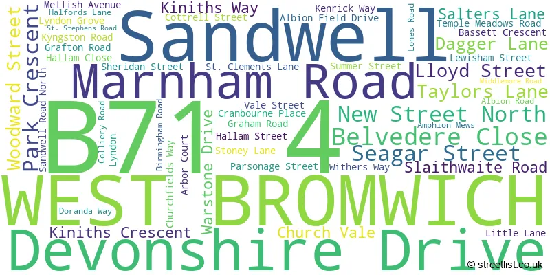
WEST BROMWICH (50 Streets)
Sandwell (1 Streets)
Unofficial Streets or Alternative Spellings
Handsworth
MIDDLEMORE ROAD PARK LANE ALL SAINTS INTERCHANGE BEACON WAY CHRISTINA COURT CHURCH VALE MEWS CHURCHFIELD WAY CHURCHVIEW WALK HALLAM DRIVE HOLLYOAK STREET MIDDLEMORE BUSINESS PARK THE EXPRESSWAY THE MINERS TRAIL (BLACK) THE MINERS TRAIL (BLUE) THE MINERS TRAIL (RED) WEST BROMWICH INTERCHANGE WEST BROMWICH PARKWAYWEST BROMWICH
ALL SAINTS WAY REFORM STREET STANWAY ROADSMETHWICK,
HALFORDS LANEGreat Barr
NEWTON ROADWeather Forecast for B71 4
Press Button to Show Forecast for West Bromwich
| Time Period | Icon | Description | Temperature | Rain Probability | Wind |
|---|---|---|---|---|---|
| 03:00 to 06:00 | Cloudy | 5.0°C (feels like 3.0°C) | 3.00% | N 4 mph | |
| 06:00 to 09:00 | Partly cloudy (day) | 5.0°C (feels like 3.0°C) | 0.00% | N 4 mph | |
| 09:00 to 12:00 | Cloudy | 7.0°C (feels like 5.0°C) | 4.00% | N 4 mph | |
| 12:00 to 15:00 | Cloudy | 10.0°C (feels like 8.0°C) | 4.00% | NNW 9 mph | |
| 15:00 to 18:00 | Overcast | 11.0°C (feels like 9.0°C) | 8.00% | N 9 mph | |
| 18:00 to 21:00 | Overcast | 10.0°C (feels like 9.0°C) | 8.00% | NNE 7 mph | |
| 21:00 to 00:00 | Cloudy | 8.0°C (feels like 7.0°C) | 5.00% | NE 4 mph |
Press Button to Show Forecast for West Bromwich
| Time Period | Icon | Description | Temperature | Rain Probability | Wind |
|---|---|---|---|---|---|
| 00:00 to 03:00 | Cloudy | 6.0°C (feels like 5.0°C) | 4.00% | NNE 4 mph | |
| 03:00 to 06:00 | Cloudy | 5.0°C (feels like 4.0°C) | 7.00% | ENE 4 mph | |
| 06:00 to 09:00 | Overcast | 5.0°C (feels like 4.0°C) | 9.00% | NNE 4 mph | |
| 09:00 to 12:00 | Overcast | 7.0°C (feels like 5.0°C) | 9.00% | NNE 7 mph | |
| 12:00 to 15:00 | Cloudy | 9.0°C (feels like 7.0°C) | 9.00% | NE 9 mph | |
| 15:00 to 18:00 | Overcast | 10.0°C (feels like 8.0°C) | 13.00% | NE 9 mph | |
| 18:00 to 21:00 | Cloudy | 9.0°C (feels like 7.0°C) | 8.00% | NE 7 mph | |
| 21:00 to 00:00 | Cloudy | 7.0°C (feels like 5.0°C) | 7.00% | ENE 7 mph |
Press Button to Show Forecast for West Bromwich
| Time Period | Icon | Description | Temperature | Rain Probability | Wind |
|---|---|---|---|---|---|
| 00:00 to 03:00 | Cloudy | 5.0°C (feels like 3.0°C) | 7.00% | ENE 4 mph | |
| 03:00 to 06:00 | Cloudy | 4.0°C (feels like 2.0°C) | 8.00% | ENE 4 mph | |
| 06:00 to 09:00 | Overcast | 4.0°C (feels like 3.0°C) | 14.00% | NE 4 mph | |
| 09:00 to 12:00 | Cloudy | 6.0°C (feels like 5.0°C) | 14.00% | ESE 4 mph | |
| 12:00 to 15:00 | Light rain | 8.0°C (feels like 6.0°C) | 44.00% | SE 7 mph | |
| 15:00 to 18:00 | Light rain | 8.0°C (feels like 7.0°C) | 43.00% | ESE 7 mph | |
| 18:00 to 21:00 | Overcast | 8.0°C (feels like 7.0°C) | 17.00% | ESE 7 mph | |
| 21:00 to 00:00 | Cloudy | 7.0°C (feels like 6.0°C) | 16.00% | ENE 7 mph |
Press Button to Show Forecast for West Bromwich
| Time Period | Icon | Description | Temperature | Rain Probability | Wind |
|---|---|---|---|---|---|
| 00:00 to 03:00 | Cloudy | 6.0°C (feels like 5.0°C) | 9.00% | ENE 4 mph | |
| 03:00 to 06:00 | Overcast | 6.0°C (feels like 4.0°C) | 10.00% | NNE 4 mph | |
| 06:00 to 09:00 | Overcast | 6.0°C (feels like 4.0°C) | 9.00% | NNE 7 mph | |
| 09:00 to 12:00 | Cloudy | 8.0°C (feels like 6.0°C) | 7.00% | NE 7 mph | |
| 12:00 to 15:00 | Cloudy | 10.0°C (feels like 8.0°C) | 10.00% | NE 9 mph | |
| 15:00 to 18:00 | Cloudy | 12.0°C (feels like 10.0°C) | 16.00% | NE 9 mph | |
| 18:00 to 21:00 | Overcast | 11.0°C (feels like 9.0°C) | 17.00% | NE 9 mph | |
| 21:00 to 00:00 | Partly cloudy (night) | 8.0°C (feels like 6.0°C) | 3.00% | NE 7 mph |
Schools and Places of Education Within the B71 4 Postcode Sector
Eaton Valley Primary School
Community school
Dagger Lane, West Bromwich, West Midlands, B71 4BU
Head: Mrs Claire Evans
Ofsted Rating: Good
Inspection: 2023-02-09 (436 days ago)
Website: Visit Eaton Valley Primary School Website
Phone: 01215531593
Number of Pupils: 464
Sandwell Academy
Academy sponsor led
Halfords Lane, West Bromwich, West Midlands, B71 4LG
Head: Mr James Saunders
Ofsted Rating: Outstanding
Inspection: 2014-01-17 (3746 days ago)
Website: Visit Sandwell Academy Website
Phone: 01215251700
Number of Pupils: 1325
House Prices in the B71 4 Postcode Sector
| Type of Property | 2018 Average | 2018 Sales | 2017 Average | 2017 Sales | 2016 Average | 2016 Sales | 2015 Average | 2015 Sales |
|---|---|---|---|---|---|---|---|---|
| Detached | £172,600 | 5 | £190,772 | 9 | £277,600 | 5 | £233,545 | 11 |
| Semi-Detached | £176,576 | 25 | £156,480 | 25 | £168,739 | 23 | £161,083 | 24 |
| Terraced | £137,667 | 15 | £123,890 | 15 | £136,188 | 12 | £115,615 | 17 |
| Flats | £104,833 | 3 | £97,000 | 5 | £89,731 | 13 | £68,825 | 6 |
Important Postcodes B71 4 in the Postcode Sector
B71 4BB is the postcode for Sandwell Deaf Community Association, Dagger Lane
B71 4BG is the postcode for King George Pavillion, Sandwell Valley Country Park, Sandwell Metropolitan Borough Council, Sandwell Park Farm Visitor Centre, Salters Lane, and Sandwell Park Farm, Salters Lane
B71 4BU is the postcode for Eaton Valley Primary School, Dagger Lane
B71 4DL is the postcode for Darzi West Bromwich, Parsonage Street, and Darzi, Parsonage Street
B71 4HJ is the postcode for BLOCK 6, MEDICAL EDUCATION CENTRE, Sandwell and West Birmingham Hospitals NHS Trust, Sandwell General Hospital, BLOCK 10 ANTE-NATAL DEPARTMENT, Sandwell and West Birmingham Hospitals NHS Trust, Sandwell General Hospital, Sandwell and West Birmingham Hospitals NHS Trust, Sandwell General Hospital, BLOCK 12, WOMEN'S HEALTH UNIT, Sandwell and West Birmingham Hospitals NHS Trust, Sandwell General Hospital, BLOCK 8, KITCHEN AND DINING ROOMS, Sandwell and West Birmingham Hospitals NHS Trust, Sandwell General Hospital, BLOCK 2, NURSES HOME AND MANAGEMENT BLOCK, Sandwell and West Birmingham Hospitals NHS Trust, Sandwell General Hospital, BLOCKS 16-19, OLD HALLAM BLOCKS, Sandwell and West Birmingham Hospitals NHS Trust, Sandwell General Hospital, BLOCK 1 MAIN HOSPITAL, WARDS AND DEPARTMENT, Sandwell and West Birmingham Hospitals NHS Trust, Sandwell General Hospital, and BLOCK 1A, EMERGENCY SERVICES BUILDING, Sandwell and West Birmingham Hospitals NHS Trust, Sandwell General Hospital
B71 4JA is the postcode for Stoney Lane Day Centre, Stoney Lane
B71 4LG is the postcode for Sandwell Academy, Halfords Lane
B71 4NH is the postcode for RESOURCE CENTRE, Black Country Mental Health NHS Trust, Hallam Street, and Sandwell Mental Health NHS and Social Care Trust, Hallam Street Hospital
| The B71 4 Sector is within these Local Authorities |
|
|---|---|
| The B71 4 Sector is within these Counties |
|
| The B71 4 Sector is within these Water Company Areas |
|