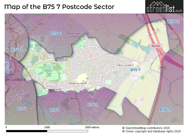
The B75 7 postcode sector stands on the Warwickshire and West Midlands border.
Did you know? According to the 2021 Census, the B75 7 postcode sector is home to a bustling 10,278 residents!
Given that each sector allows for 400 unique postcode combinations. Letters C, I, K, M, O and V are not allowed in the last two letters of a postcode. With 219 postcodes already in use, this leaves 181 units available.
The B75 7 postal code covers the settlement of SUTTON COLDFIELD.
The B75 7 Postcode shares a border with B74 2 (SUTTON COLDFIELD, Streetly), B76 1 (SUTTON COLDFIELD, Minworth), B76 2 (SUTTON COLDFIELD), B76 9 (Minworth, Curdworth, Wishaw), B72 1 (SUTTON COLDFIELD), B75 6 (SUTTON COLDFIELD, Bassetts Pole) and B78 2 (Kingsbury, Middleton, Piccadilly).
The sector is within the post town of SUTTON COLDFIELD.
B75 7 is a postcode sector within the B75 postcode district which is within the B Birmingham postcode area.
The Royal Mail delivery office for the B75 7 postal sector is the Sutton Coldfield Postal Delivery Office.
The area of the B75 7 postcode sector is 1.79 square miles which is 4.63 square kilometres or 1,143.68 square acres.
The B75 7 postcode sector is crossed by the A38 Major A road.
The B75 7 postcode sector is crossed by the M6 motorway.
Waterways within the B75 7 postcode sector include the Churchill Brook, Langley Brook, Collets Brook.

Map of the B75 7 Postcode Sector
Explore the B75 7 postcode sector by using our free interactive map.
| B | 7 | 5 | - | 7 | X | X |
| B | 7 | 5 | Space | 7 | Letter | Letter |
Official List of Streets
SUTTON COLDFIELD (111 Streets)
Unofficial Streets or Alternative Spellings
SUTTON COLDFIELD
BEDFORD ROAD BETTERIDGE DRIVE BOSWELL ROAD CHURCHILL PARADE COLESHILL STREET FOX HOLLIES ROAD HOLLYFIELD ROAD SOUTH LISURES DRIVE MIDLAND DRIVE ROYAL ROAD SPRINGFIELD CRESCENT ST. JUDES CLOSE WALMLEY ROAD WALSH DRIVE WEST VIEW ROAD WHITEHOUSE COMMON ROAD WIMBOURNE ROADWishaw
OX LEYS ROADBassetts Pole
LONDON ROAD CEMETERY ROAD FREEMAN DRIVE JERRARD MEWS LANGLEY PARKWAY SUTTON COLDFIELD BYPASS WHEATMORE ROADWeather Forecast for B75 7
Press Button to Show Forecast for Whitehouse Common
| Time Period | Icon | Description | Temperature | Rain Probability | Wind |
|---|---|---|---|---|---|
| 09:00 to 12:00 | Cloudy | 8.0°C (feels like 6.0°C) | 8.00% | N 11 mph | |
| 12:00 to 15:00 | Cloudy | 10.0°C (feels like 7.0°C) | 9.00% | N 11 mph | |
| 15:00 to 18:00 | Cloudy | 11.0°C (feels like 8.0°C) | 5.00% | NNE 11 mph | |
| 18:00 to 21:00 | Cloudy | 10.0°C (feels like 8.0°C) | 5.00% | NNE 9 mph | |
| 21:00 to 00:00 | Cloudy | 8.0°C (feels like 6.0°C) | 5.00% | NNE 4 mph |
Press Button to Show Forecast for Whitehouse Common
| Time Period | Icon | Description | Temperature | Rain Probability | Wind |
|---|---|---|---|---|---|
| 00:00 to 03:00 | Cloudy | 6.0°C (feels like 5.0°C) | 5.00% | N 4 mph | |
| 03:00 to 06:00 | Cloudy | 6.0°C (feels like 4.0°C) | 8.00% | NNW 4 mph | |
| 06:00 to 09:00 | Cloudy | 5.0°C (feels like 3.0°C) | 4.00% | N 7 mph | |
| 09:00 to 12:00 | Sunny day | 7.0°C (feels like 4.0°C) | 1.00% | N 7 mph | |
| 12:00 to 15:00 | Partly cloudy (day) | 10.0°C (feels like 8.0°C) | 1.00% | N 7 mph | |
| 15:00 to 18:00 | Partly cloudy (day) | 11.0°C (feels like 9.0°C) | 1.00% | N 7 mph | |
| 18:00 to 21:00 | Sunny day | 10.0°C (feels like 8.0°C) | 1.00% | N 7 mph | |
| 21:00 to 00:00 | Clear night | 6.0°C (feels like 4.0°C) | 1.00% | NW 7 mph |
Press Button to Show Forecast for Whitehouse Common
| Time Period | Icon | Description | Temperature | Rain Probability | Wind |
|---|---|---|---|---|---|
| 00:00 to 03:00 | Cloudy | 4.0°C (feels like 2.0°C) | 4.00% | WNW 7 mph | |
| 03:00 to 06:00 | Cloudy | 4.0°C (feels like 1.0°C) | 4.00% | W 7 mph | |
| 06:00 to 09:00 | Cloudy | 5.0°C (feels like 2.0°C) | 5.00% | W 7 mph | |
| 09:00 to 12:00 | Cloudy | 7.0°C (feels like 4.0°C) | 9.00% | WNW 9 mph | |
| 12:00 to 15:00 | Cloudy | 9.0°C (feels like 7.0°C) | 11.00% | NW 9 mph | |
| 15:00 to 18:00 | Cloudy | 9.0°C (feels like 7.0°C) | 9.00% | NNW 9 mph | |
| 18:00 to 21:00 | Cloudy | 9.0°C (feels like 7.0°C) | 5.00% | NNW 7 mph | |
| 21:00 to 00:00 | Partly cloudy (night) | 6.0°C (feels like 5.0°C) | 3.00% | NNE 4 mph |
Press Button to Show Forecast for Whitehouse Common
| Time Period | Icon | Description | Temperature | Rain Probability | Wind |
|---|---|---|---|---|---|
| 00:00 to 03:00 | Cloudy | 5.0°C (feels like 3.0°C) | 6.00% | ENE 4 mph | |
| 03:00 to 06:00 | Cloudy | 4.0°C (feels like 2.0°C) | 9.00% | ENE 4 mph | |
| 06:00 to 09:00 | Cloudy | 4.0°C (feels like 2.0°C) | 12.00% | E 4 mph | |
| 09:00 to 12:00 | Cloudy | 6.0°C (feels like 4.0°C) | 15.00% | ESE 7 mph | |
| 12:00 to 15:00 | Overcast | 9.0°C (feels like 7.0°C) | 19.00% | ESE 7 mph | |
| 15:00 to 18:00 | Overcast | 9.0°C (feels like 7.0°C) | 19.00% | ESE 7 mph | |
| 18:00 to 21:00 | Cloudy | 8.0°C (feels like 6.0°C) | 21.00% | E 9 mph | |
| 21:00 to 00:00 | Cloudy | 7.0°C (feels like 4.0°C) | 25.00% | E 7 mph |
Press Button to Show Forecast for Whitehouse Common
| Time Period | Icon | Description | Temperature | Rain Probability | Wind |
|---|---|---|---|---|---|
| 00:00 to 03:00 | Cloudy | 6.0°C (feels like 3.0°C) | 23.00% | E 7 mph | |
| 03:00 to 06:00 | Overcast | 5.0°C (feels like 3.0°C) | 26.00% | E 7 mph | |
| 06:00 to 09:00 | Light rain | 5.0°C (feels like 3.0°C) | 51.00% | E 7 mph | |
| 09:00 to 12:00 | Overcast | 7.0°C (feels like 5.0°C) | 21.00% | ENE 9 mph | |
| 12:00 to 15:00 | Cloudy | 10.0°C (feels like 7.0°C) | 22.00% | E 9 mph | |
| 15:00 to 18:00 | Cloudy | 10.0°C (feels like 8.0°C) | 22.00% | E 9 mph | |
| 18:00 to 21:00 | Cloudy | 10.0°C (feels like 8.0°C) | 23.00% | ENE 9 mph | |
| 21:00 to 00:00 | Light rain | 8.0°C (feels like 6.0°C) | 50.00% | NE 7 mph |
Schools and Places of Education Within the B75 7 Postcode Sector
Fairfax
Academy converter
Fairfax Road, Sutton Coldfield, West Midlands, B75 7JT
Head: Mr Sean Castle
Ofsted Rating: Good
Inspection: 2019-03-19 (1862 days ago)
Website: Visit Fairfax Website
Phone: 01213781288
Number of Pupils: 1570
Hollyfield Primary School
Foundation school
Hollyfield Road, Sutton Coldfield, West Midlands, B75 7SG
Head: Mr Andy Holmes
Ofsted Rating: Good
Inspection: 2022-11-23 (517 days ago)
Website: Visit Hollyfield Primary School Website
Phone: 01213780672
Number of Pupils: 415
John Willmott School
Academy sponsor led
Reddicap Heath Road, Sutton Coldfield, West Midlands, B75 7DY
Head: Mrs Nicola Gould
Ofsted Rating: Good
Inspection: 2023-12-07 (138 days ago)
Website: Visit John Willmott School Website
Phone: 01213781946
Number of Pupils: 924
New Hall Primary School
Community school
Langley Hall Drive, Sutton Coldfield, West Midlands, B75 7NQ
Head: Mrs Becci Breedon
Ofsted Rating: Good
Inspection: 2023-03-23 (397 days ago)
Website: Visit New Hall Primary School Website
Phone: 01214645170
Number of Pupils: 324
Trinity Specialist College
Special post 16 institution
The Lindridge, Lindridge Road, Sutton Coldfield, West Midlands, B75 7JB
Head: Mrs Lindsay Harris
Ofsted Rating: Good
Inspection: 2019-02-01 (1908 days ago)
Website: Visit Trinity Specialist College Website
Phone: 01213783242
Number of Pupils: 0
House Prices in the B75 7 Postcode Sector
| Type of Property | 2018 Average | 2018 Sales | 2017 Average | 2017 Sales | 2016 Average | 2016 Sales | 2015 Average | 2015 Sales |
|---|---|---|---|---|---|---|---|---|
| Detached | £402,250 | 28 | £386,277 | 24 | £333,623 | 50 | £321,165 | 39 |
| Semi-Detached | £254,682 | 72 | £224,517 | 72 | £222,036 | 76 | £197,398 | 62 |
| Terraced | £212,296 | 50 | £188,488 | 61 | £181,775 | 52 | £171,762 | 53 |
| Flats | £114,768 | 31 | £122,159 | 22 | £106,468 | 28 | £103,744 | 34 |
Important Postcodes B75 7 in the Postcode Sector
B75 7BD is the postcode for The Pavilion, Rectory Park, Broomie Close
B75 7BU is the postcode for 6 The Courtyard, Reddicap Trading Estate
B75 7DY is the postcode for MAIN BUILDING, John Willmott School, Reddicap Heath Road, JOHN WILLMOTT SCHOOL, REDDICAP HEATH ROAD, SUTTON COLDFIELD, John Willmott School, Reddicap Heath Road, and NEW BLOCK, John Willmott School, Reddicap Heath Road
B75 7EW is the postcode for 70 Reddicap Heath Road
B75 7HU is the postcode for Langley School, Lindridge Road
B75 7JT is the postcode for Fairfax School, Fairfax Road, SPORTS HALL, Fairfax School, Fairfax Road, FAIRFAX SCHOOL, FAIRFAX ROAD, SUTTON TRINITY, CRAFT BLOCK, Fairfax School, Fairfax Road, and G BLOCK, Fairfax School, Fairfax Road
B75 7LB is the postcode for Falcon Lodge Community Centre, Churchill Road
B75 7NQ is the postcode for Newhall Junior & Infant School, Langley Hall Drive, New Hall Primary School, Langley Hall Drive, and New Hall Primary School and Childrens Centre, Langley Hall Drive
B75 7RL is the postcode for Defence Infrastructure Organisation, Kingston Road
B75 7RR is the postcode for SHELDON BLOCK 031, Good Hope Hospital, Rectory Road, A&E BLOCK 009, University Hospitals Birmingham NHS Foundation Trust, Good Hope Hospital, X RAY BLOCK 005, University Hospitals Birmingham NHS Foundation Trust, Good Hope Hospital, THE PARTNERSHIP LEARNING CENTRE, University Hospitals Birmingham NHS Foundation Trust, Good Hope Hospital, A&E BLOCK 009, Good Hope Hospital, Rectory Road, WARDS 14&16 BLOCK 071, University Hospitals Birmingham NHS Foundation Trust, Good Hope Hospital, ORTHOPAEDIC & REHAB CENTRE BLOCK 074, University Hospitals Birmingham NHS Foundation Trust, Good Hope Hospital, OPD BLOCK 004, University Hospitals Birmingham NHS Foundation Trust, Good Hope Hospital, TREATMENT CENTRE BLOCK 095, University Hospitals Birmingham NHS Foundation Trust, Good Hope Hospital, BLOCK 7 PHARMACY, University Hospitals Birmingham NHS Foundation Trust, Good Hope Hospital, GROUND FLOOR THEATRES BLOCK 030, University Hospitals Birmingham NHS Foundation Trust, Good Hope Hospital, SHELDON BLOCK 032, University Hospitals Birmingham NHS Foundation Trust, Good Hope Hospital, FOTHERGILL BLOCK 010, University Hospitals Birmingham NHS Foundation Trust, Good Hope Hospital, WARD 18, University Hospitals Birmingham NHS Foundation Trust, Good Hope Hospital, WARDS 15/17 BLOCK 071, University Hospitals Birmingham NHS Foundation Trust, Good Hope Hospital, Heart Of England NHS Foundation Trust, Good Hope Hospital, THE EDUCATION CENTRE, University Hospitals Birmingham NHS Foundation Trust, Good Hope Hospital, WARD BLOCK 1, University Hospitals Birmingham NHS Foundation Trust, Good Hope Hospital, SHELDON BLOCK 031, University Hospitals Birmingham NHS Foundation Trust, Good Hope Hospital, WARDS 15&17 BLOCK 072, University Hospitals Birmingham NHS Foundation Trust, Good Hope Hospital, DINING ROOM BLOCK 001, University Hospitals Birmingham NHS Foundation Trust, Good Hope Hospital, RICHARD SALT UNIT BLOCK 011, University Hospitals Birmingham NHS Foundation Trust, Good Hope Hospital, WARDS 14/16 BLOCK 072, University Hospitals Birmingham NHS Foundation Trust, Good Hope Hospital, NEW WARD BLOCK 70, University Hospitals Birmingham NHS Foundation Trust, Good Hope Hospital, and WARD 19, University Hospitals Birmingham NHS Foundation Trust, Good Hope Hospital
B75 7SG is the postcode for INFANTS SCHOOL, Hollyfield Primary School, Hollyfield Road, Hollyfield Primary School, Hollyfield Road, RECEPTION SCHOOL, Hollyfield Primary School, Hollyfield Road, and JUNIOR SCHOOL, Hollyfield Primary School, Hollyfield Road
| The B75 7 Sector is within these Local Authorities |
|
|---|---|
| The B75 7 Sector is within these Counties |
|
| The B75 7 Sector is within these Water Company Areas |
|