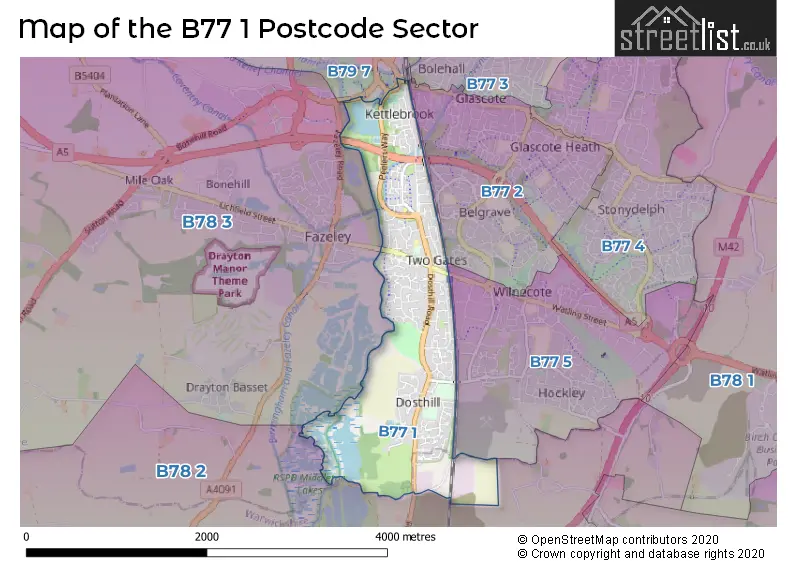
The B77 1 postcode sector stands on the Staffordshire and Warwickshire border.
Did you know? According to the 2021 Census, the B77 1 postcode sector is home to a bustling 10,733 residents!
Given that each sector allows for 400 unique postcode combinations. Letters C, I, K, M, O and V are not allowed in the last two letters of a postcode. With 172 postcodes already in use, this leaves 228 units available.
The largest settlement in the B77 1 postal code is TAMWORTH followed by Dosthill, and Two Gates.
The B77 1 Postcode shares a border with B77 2 (TAMWORTH, Glascote, Wilnecote), B77 3 (TAMWORTH, Amington, Bolehall), B77 5 (Wilnecote, Hockley, TAMWORTH), B78 2 (Kingsbury, Middleton, Piccadilly), B78 3 (TAMWORTH, Fazeley, Mile Oak) and B79 7 (TAMWORTH).
The sector is within the post town of TAMWORTH.
B77 1 is a postcode sector within the B77 postcode district which is within the B Birmingham postcode area.
The Royal Mail delivery office for the B77 1 postal sector is the Tamworth Delivery Office.
The area of the B77 1 postcode sector is 1.70 square miles which is 4.40 square kilometres or 1,088.35 square acres.
The B77 1 postcode sector is crossed by the A5 Major A road.
Waterways within the B77 1 postcode sector include the Coventry Canal, River Tame.

Map of the B77 1 Postcode Sector
Explore the B77 1 postcode sector by using our free interactive map.
| B | 7 | 7 | - | 1 | X | X |
| B | 7 | 7 | Space | 1 | Letter | Letter |
Official List of Streets
TAMWORTH (56 Streets)
Dosthill (45 Streets)
Two Gates (12 Streets)
Unofficial Streets or Alternative Spellings
Dosthill
CHURCH FARM MEWS ANKERDRIVE DOSTHILL BYPASS EAST STREET HERON COURT MORMET COURT PEEL PLACE PEELERS WAY RIVERDRIVE SCHOOL LANETAMWORTH
WILNECOTE LANEFazeley
WATLING STREETGlascote
GLASCOTE ROADCliff
TAMWORTH ROADWeather Forecast for B77 1
Press Button to Show Forecast for Snowdome Tamworth
| Time Period | Icon | Description | Temperature | Rain Probability | Wind |
|---|---|---|---|---|---|
| 21:00 to 00:00 | Cloudy | 7.0°C (feels like 5.0°C) | 8.00% | ENE 4 mph |
Press Button to Show Forecast for Snowdome Tamworth
| Time Period | Icon | Description | Temperature | Rain Probability | Wind |
|---|---|---|---|---|---|
| 00:00 to 03:00 | Cloudy | 5.0°C (feels like 3.0°C) | 11.00% | E 4 mph | |
| 03:00 to 06:00 | Cloudy | 4.0°C (feels like 2.0°C) | 5.00% | ENE 4 mph | |
| 06:00 to 09:00 | Cloudy | 4.0°C (feels like 2.0°C) | 4.00% | ENE 4 mph | |
| 09:00 to 12:00 | Cloudy | 7.0°C (feels like 5.0°C) | 5.00% | ENE 7 mph | |
| 12:00 to 15:00 | Overcast | 9.0°C (feels like 8.0°C) | 10.00% | ENE 4 mph | |
| 15:00 to 18:00 | Cloudy | 10.0°C (feels like 9.0°C) | 8.00% | ENE 4 mph | |
| 18:00 to 21:00 | Overcast | 9.0°C (feels like 8.0°C) | 16.00% | E 7 mph | |
| 21:00 to 00:00 | Partly cloudy (night) | 7.0°C (feels like 5.0°C) | 8.00% | ENE 7 mph |
Press Button to Show Forecast for Snowdome Tamworth
| Time Period | Icon | Description | Temperature | Rain Probability | Wind |
|---|---|---|---|---|---|
| 00:00 to 03:00 | Cloudy | 5.0°C (feels like 3.0°C) | 12.00% | ENE 7 mph | |
| 03:00 to 06:00 | Cloudy | 5.0°C (feels like 2.0°C) | 12.00% | ENE 7 mph | |
| 06:00 to 09:00 | Cloudy | 5.0°C (feels like 2.0°C) | 13.00% | ENE 7 mph | |
| 09:00 to 12:00 | Cloudy | 8.0°C (feels like 5.0°C) | 17.00% | ENE 9 mph | |
| 12:00 to 15:00 | Overcast | 9.0°C (feels like 7.0°C) | 24.00% | ENE 9 mph | |
| 15:00 to 18:00 | Light rain | 10.0°C (feels like 8.0°C) | 49.00% | ENE 9 mph | |
| 18:00 to 21:00 | Cloudy | 10.0°C (feels like 8.0°C) | 19.00% | ENE 9 mph | |
| 21:00 to 00:00 | Cloudy | 8.0°C (feels like 6.0°C) | 21.00% | NE 9 mph |
Press Button to Show Forecast for Snowdome Tamworth
| Time Period | Icon | Description | Temperature | Rain Probability | Wind |
|---|---|---|---|---|---|
| 00:00 to 03:00 | Overcast | 7.0°C (feels like 5.0°C) | 22.00% | NE 9 mph | |
| 03:00 to 06:00 | Light rain | 7.0°C (feels like 4.0°C) | 52.00% | NE 9 mph | |
| 06:00 to 09:00 | Heavy rain | 7.0°C (feels like 5.0°C) | 75.00% | NE 9 mph | |
| 09:00 to 12:00 | Heavy rain | 9.0°C (feels like 7.0°C) | 76.00% | NNE 9 mph | |
| 12:00 to 15:00 | Light rain shower (day) | 11.0°C (feels like 9.0°C) | 43.00% | NNW 9 mph | |
| 15:00 to 18:00 | Light rain | 11.0°C (feels like 9.0°C) | 54.00% | SE 9 mph | |
| 18:00 to 21:00 | Light rain shower (day) | 11.0°C (feels like 9.0°C) | 41.00% | WSW 9 mph | |
| 21:00 to 00:00 | Partly cloudy (night) | 9.0°C (feels like 8.0°C) | 11.00% | SSW 7 mph |
Schools and Places of Education Within the B77 1 Postcode Sector
Dosthill Primary School
Academy sponsor led
High Street, Tamworth, , B77 1LQ
Head: Mr David Shakeshaft
Ofsted Rating: Requires improvement
Inspection: 2022-06-09 (686 days ago)
Website: Visit Dosthill Primary School Website
Phone: 01827214930
Number of Pupils: 529
Kettlebrook Short Stay School
Pupil referral unit
Tame Street, Tamworth, Staffordshire, B77 1AL
Head: Mrs Kirsty Rogers
Ofsted Rating: Good
Inspection: 2018-10-04 (2030 days ago)
Website: Visit Kettlebrook Short Stay School Website
Phone: 01827312840
Number of Pupils: 45
Two Gates Primary School
Academy sponsor led
Tamworth Road, Tamworth, Staffordshire, B77 1EN
Head: Mrs Nest Llewelyn-Cook
Ofsted Rating: Good
Inspection: 2023-05-18 (343 days ago)
Website: Visit Two Gates Primary School Website
Phone: 01827213855
Number of Pupils: 249
House Prices in the B77 1 Postcode Sector
| Type of Property | 2018 Average | 2018 Sales | 2017 Average | 2017 Sales | 2016 Average | 2016 Sales | 2015 Average | 2015 Sales |
|---|---|---|---|---|---|---|---|---|
| Detached | £293,634 | 67 | £291,472 | 91 | £273,638 | 81 | £263,735 | 46 |
| Semi-Detached | £197,879 | 74 | £185,493 | 67 | £176,392 | 74 | £159,624 | 54 |
| Terraced | £165,865 | 46 | £151,371 | 41 | £149,086 | 61 | £128,446 | 46 |
| Flats | £126,263 | 19 | £93,000 | 1 | £137,833 | 3 | £122,313 | 8 |
Important Postcodes B77 1 in the Postcode Sector
B77 1AL is the postcode for Kettlebrook Pupil Referral Unit, Tame Street
B77 1EN is the postcode for Two Gates Primary School, Tamworth Road, Two Gates, and Two Gates Primary School, Tamworth Road
B77 1LQ is the postcode for Staffordshire County Council, Dosthill School, High Street, and DOSTHILL PRIMARY SCHOOL, HIGH STREET, DOSTHILL
| The B77 1 Sector is within these Local Authorities |
|
|---|---|
| The B77 1 Sector is within these Counties |
|
| The B77 1 Sector is within these Water Company Areas |
|