The B98 postcode district is a postal district located in the B Birmingham postcode area with a population of 50,297 residents according to the 2021 England and Wales Census.
The area of the B98 postcode district is 11.72 square miles which is 30.35 square kilometres or 7,499.37 acres.
Currently, the B98 district has about 816 postcode units spread across 4 geographic postcode sectors.
Given that each sector allows for 400 unique postcode combinations, the district has a capacity of 1,600 postcodes. With 816 postcodes already in use, this leaves 784 units available.
The largest settlement in the B98 postal code is REDDITCH followed by Beoley, and Moons Moat North Industrial Estate.
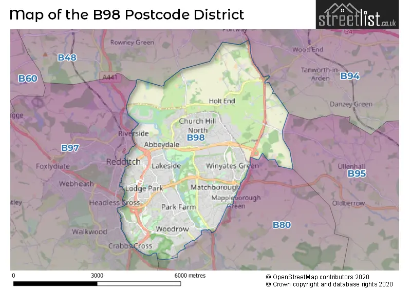
The B98 Postcode shares a border with B94 (Hockley Heath, Lapworth, Earlswood), B80 (STUDLEY, Mappleborough Green, Morton Bagot), B97 (REDDITCH, Callow Hill, Kingfisher Shopping Centre) and B48 (Alvechurch, Portway).
The primary settlement in the B98 postcode district is Redditch, which is located in Worcestershire, England. Other significant settlements include Ipsley, Park Farm Industrial Estate, Beoley, Church Hill North, and Moons Moat North Industrial Estate. The most significant post town in the district is Redditch.
For the district B98, we have data on 4 postcode sectors. Here's a breakdown: The sector B98 0, covers Redditch in Worcestershire. The sector B98 7, covers Redditch in Worcestershire. The sector B98 8, covers Redditch in Worcestershire. The sector B98 9, covers Redditch and Beoley and Moons Moat North Industrial Estate in Worcestershire.


Map of the B98 Postcode District
Explore the B98 postcode district by using our free interactive map.
When it comes to local government, postal geography often disregards political borders. However, for a breakdown in the B98 District: the district mostly encompasses the Redditch District (B) (766 postcodes), followed by the Bromsgrove District area (39 postcodes), and finally, the Stratford-on-Avon District area (10 postcodes).
Weather Forecast for B98
Press Button to Show Forecast for Redditch
| Time Period | Icon | Description | Temperature | Rain Probability | Wind |
|---|---|---|---|---|---|
| 18:00 to 21:00 | Cloudy | 10.0°C (feels like 9.0°C) | 4.00% | NNW 4 mph | |
| 21:00 to 00:00 | Clear night | 6.0°C (feels like 5.0°C) | 0.00% | NW 4 mph |
Press Button to Show Forecast for Redditch
| Time Period | Icon | Description | Temperature | Rain Probability | Wind |
|---|---|---|---|---|---|
| 00:00 to 03:00 | Partly cloudy (night) | 5.0°C (feels like 3.0°C) | 0.00% | NW 4 mph | |
| 03:00 to 06:00 | Cloudy | 3.0°C (feels like 1.0°C) | 4.00% | W 4 mph | |
| 06:00 to 09:00 | Overcast | 4.0°C (feels like 2.0°C) | 10.00% | WSW 4 mph | |
| 09:00 to 12:00 | Cloudy | 8.0°C (feels like 5.0°C) | 10.00% | WNW 7 mph | |
| 12:00 to 15:00 | Cloudy | 9.0°C (feels like 7.0°C) | 9.00% | NW 9 mph | |
| 15:00 to 18:00 | Cloudy | 10.0°C (feels like 8.0°C) | 8.00% | N 9 mph | |
| 18:00 to 21:00 | Cloudy | 9.0°C (feels like 7.0°C) | 7.00% | NNE 7 mph | |
| 21:00 to 00:00 | Cloudy | 6.0°C (feels like 5.0°C) | 5.00% | NE 4 mph |
Press Button to Show Forecast for Redditch
| Time Period | Icon | Description | Temperature | Rain Probability | Wind |
|---|---|---|---|---|---|
| 00:00 to 03:00 | Cloudy | 5.0°C (feels like 3.0°C) | 6.00% | E 7 mph | |
| 03:00 to 06:00 | Cloudy | 4.0°C (feels like 2.0°C) | 5.00% | ENE 4 mph | |
| 06:00 to 09:00 | Cloudy | 4.0°C (feels like 1.0°C) | 6.00% | ENE 7 mph | |
| 09:00 to 12:00 | Cloudy | 7.0°C (feels like 4.0°C) | 7.00% | E 7 mph | |
| 12:00 to 15:00 | Overcast | 9.0°C (feels like 7.0°C) | 11.00% | E 7 mph | |
| 15:00 to 18:00 | Overcast | 10.0°C (feels like 8.0°C) | 13.00% | E 7 mph | |
| 18:00 to 21:00 | Cloudy | 9.0°C (feels like 7.0°C) | 11.00% | E 7 mph | |
| 21:00 to 00:00 | Cloudy | 6.0°C (feels like 4.0°C) | 12.00% | ENE 7 mph |
Press Button to Show Forecast for Redditch
| Time Period | Icon | Description | Temperature | Rain Probability | Wind |
|---|---|---|---|---|---|
| 00:00 to 03:00 | Cloudy | 5.0°C (feels like 2.0°C) | 13.00% | E 7 mph | |
| 03:00 to 06:00 | Cloudy | 4.0°C (feels like 2.0°C) | 15.00% | ENE 7 mph | |
| 06:00 to 09:00 | Cloudy | 5.0°C (feels like 2.0°C) | 16.00% | ENE 9 mph | |
| 09:00 to 12:00 | Cloudy | 7.0°C (feels like 4.0°C) | 19.00% | ENE 11 mph | |
| 12:00 to 15:00 | Light rain | 9.0°C (feels like 6.0°C) | 52.00% | ENE 11 mph | |
| 15:00 to 18:00 | Overcast | 10.0°C (feels like 8.0°C) | 24.00% | ENE 11 mph | |
| 18:00 to 21:00 | Cloudy | 9.0°C (feels like 7.0°C) | 19.00% | ENE 11 mph | |
| 21:00 to 00:00 | Light rain | 8.0°C (feels like 5.0°C) | 50.00% | NE 11 mph |
Press Button to Show Forecast for Redditch
| Time Period | Icon | Description | Temperature | Rain Probability | Wind |
|---|---|---|---|---|---|
| 00:00 to 03:00 | Heavy rain | 7.0°C (feels like 4.0°C) | 71.00% | NE 11 mph | |
| 03:00 to 06:00 | Light rain | 6.0°C (feels like 4.0°C) | 52.00% | NE 9 mph | |
| 06:00 to 09:00 | Light rain | 7.0°C (feels like 4.0°C) | 53.00% | NE 9 mph | |
| 09:00 to 12:00 | Heavy rain | 8.0°C (feels like 6.0°C) | 77.00% | NE 9 mph | |
| 12:00 to 15:00 | Light rain | 10.0°C (feels like 8.0°C) | 51.00% | N 11 mph | |
| 15:00 to 18:00 | Heavy rain shower (day) | 11.0°C (feels like 9.0°C) | 60.00% | N 11 mph | |
| 18:00 to 21:00 | Cloudy | 10.0°C (feels like 8.0°C) | 21.00% | NNE 9 mph | |
| 21:00 to 00:00 | Clear night | 8.0°C (feels like 6.0°C) | 11.00% | NNE 7 mph |
Where is the B98 Postcode District?
The postcode district of B98 is located in the town of Redditch. It is located near several other towns, including Studley to the south (2.47 miles away), Henley-in-Arden to the east (4.94 miles away), Bromsgrove to the west (6.12 miles away), Solihull to the north (8.93 miles away), and Halesowen to the northwest (11.37 miles away). The distance from B98 to London is approximately 94.01 miles.
The district is within the post town of REDDITCH.
The sector has postcodes within the nation of England.
The B98 Postcode District is covers the following regions.
- Worcestershire - Herefordshire, Worcestershire and Warwickshire - West Midlands (England)
- Warwickshire - Herefordshire, Worcestershire and Warwickshire - West Midlands (England)
| Postcode Sector | Delivery Office |
|---|---|
| B98 0 | Redditch Delivery Office |
| B98 7 | Redditch Delivery Office |
| B98 8 | Redditch Delivery Office |
| B98 9 | Redditch Delivery Office |
| B | 9 | 8 | - | X | X | X |
| B | 9 | 8 | Space | Numeric | Letter | Letter |
Current Monthly Rental Prices
| # Bedrooms | Min Price | Max Price | Avg Price |
|---|---|---|---|
| 1 | £375 | £725 | £520 |
| 2 | £675 | £850 | £775 |
| 3 | £900 | £1,000 | £950 |
| 4 | £1,500 | £1,500 | £1,500 |
Current House Prices
| # Bedrooms | Min Price | Max Price | Avg Price |
|---|---|---|---|
| 1 | £455,000 | £455,000 | £455,000 |
| 3 | £500,000 | £650,000 | £583,333 |
| 4 | £415,000 | £700,000 | £461,267 |
| 5 | £550,000 | £1,300,000 | £791,000 |
| 7 | £2,350,000 | £2,350,000 | £2,350,000 |
| 90 | £6,000,000 | £6,000,000 | £6,000,000 |
Estate Agents who Operate in the B98 District
| Logo | Name | Brand Name | Address | Contact Number | Total Properties |
|---|---|---|---|---|---|
 | Redditch | A P Morgan | Estate House, 12 Church Green East, Redditch, B98 8BP | 01527 913195 | 45 |
 | Redditch | Arden Estates | 373 Evesham Road, Redditch, B97 5JA | 01527 540654 | 27 |
 | Redditch | Robert Oulsnam & Company | 10A Church Green East, Redditch, B98 8BP | 01527 913625 | 18 |
 | Redditch | Shipways | 3 Alcester Street, Redditch, B98 8AE | 01527 913417 | 13 |
 | Redditch | Dixons | 10 Church Green East, Redditch, Worcestershire, B98 8BP | 01527 396268 | 11 |
| Type of Property | 2018 Average | 2018 Sales | 2017 Average | 2017 Sales | 2016 Average | 2016 Sales | 2015 Average | 2015 Sales |
|---|---|---|---|---|---|---|---|---|
| Detached | £306,876 | 177 | £283,686 | 151 | £270,825 | 154 | £258,553 | 183 |
| Semi-Detached | £198,898 | 235 | £185,417 | 196 | £178,806 | 193 | £163,048 | 194 |
| Terraced | £154,519 | 305 | £152,027 | 275 | £142,050 | 288 | £134,671 | 315 |
| Flats | £116,547 | 75 | £112,912 | 66 | £108,386 | 77 | £96,889 | 60 |