The B98 7 postcode sector stands on the Warwickshire and Worcestershire border.
Did you know? According to the 2021 Census, the B98 7 postcode sector is home to a bustling 20,258 residents!
Given that each sector allows for 400 unique postcode combinations. Letters C, I, K, M, O and V are not allowed in the last two letters of a postcode. With 295 postcodes already in use, this leaves 105 units available.
The largest settlements in the B98 7 postal code are REDDITCH and Park Farm Industrial Estate.
The B98 7 Postcode shares a border with B97 4 (REDDITCH, Kingfisher Shopping Centre), B98 0 (REDDITCH, Park Farm Industrial Estate), B80 7 (STUDLEY, Mappleborough Green, Morton Bagot), B97 5 (REDDITCH, Callow Hill, Webheath) and B98 8 (REDDITCH).
The sector is within the post town of REDDITCH.
B98 7 is a postcode sector within the B98 postcode district which is within the B Birmingham postcode area.
The Royal Mail delivery office for the B98 7 postal sector is the Redditch Delivery Office.
The area of the B98 7 postcode sector is 2.54 square miles which is 6.58 square kilometres or 1,626.40 square acres.
Waterways within the B98 7 postcode sector include the River Arrow.

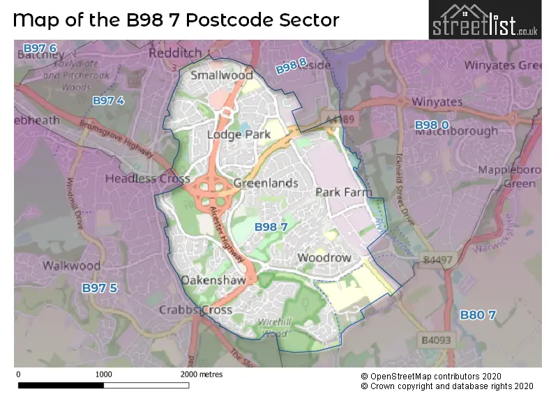
Map of the B98 7 Postcode Sector
Explore the B98 7 postcode sector by using our free interactive map.
| B | 9 | 8 | - | 7 | X | X |
| B | 9 | 8 | Space | 7 | Letter | Letter |
Official List of Streets
REDDITCH (177 Streets)
Park Farm Industrial Estate (3 Streets)
Unofficial Streets or Alternative Spellings
REDDITCH
ALVECHURCH HIGHWAY ARTHUR STREET BEOLEY ROAD WEST HOLLOWAY DRIVE OTHER ROAD POOL BANK REDDITCH RINGWAY SILLINS AVENUE TORRS CLOSESTUDLEY
BRICKYARD LANE GREEN LANE ALCESTER HIGHWAY BROMSGROVE HIGHWAY BURTON LANE GRANGERS LANE GREENLANDS DRIVE HALLOWFIELDS CLOSE JET WASH POOL PLACE ROUGH HILL DRIVE SILVER STREET STATION WAY TUNNEL DRIVE TWINERS ROAD WEST STREET WINTERBORNE CLOSE WOODROW NORTH WOODROW SOUTH WOODROW WALKPark Farm Industrial Estate
PIPERS ROAD WASHFORD DRIVEMappleborough Green
WARWICK HIGHWAYWeather Forecast for B98 7
Press Button to Show Forecast for Redditch
| Time Period | Icon | Description | Temperature | Rain Probability | Wind |
|---|---|---|---|---|---|
| 09:00 to 12:00 | Cloudy | 8.0°C (feels like 5.0°C) | 10.00% | WNW 7 mph | |
| 12:00 to 15:00 | Cloudy | 9.0°C (feels like 7.0°C) | 9.00% | NW 9 mph | |
| 15:00 to 18:00 | Cloudy | 10.0°C (feels like 8.0°C) | 8.00% | N 9 mph | |
| 18:00 to 21:00 | Cloudy | 9.0°C (feels like 7.0°C) | 7.00% | NNE 7 mph | |
| 21:00 to 00:00 | Cloudy | 6.0°C (feels like 5.0°C) | 5.00% | NE 4 mph |
Press Button to Show Forecast for Redditch
| Time Period | Icon | Description | Temperature | Rain Probability | Wind |
|---|---|---|---|---|---|
| 00:00 to 03:00 | Cloudy | 5.0°C (feels like 3.0°C) | 6.00% | E 7 mph | |
| 03:00 to 06:00 | Cloudy | 4.0°C (feels like 2.0°C) | 5.00% | ENE 4 mph | |
| 06:00 to 09:00 | Cloudy | 4.0°C (feels like 1.0°C) | 6.00% | ENE 7 mph | |
| 09:00 to 12:00 | Cloudy | 7.0°C (feels like 4.0°C) | 7.00% | E 7 mph | |
| 12:00 to 15:00 | Overcast | 9.0°C (feels like 7.0°C) | 11.00% | E 7 mph | |
| 15:00 to 18:00 | Overcast | 10.0°C (feels like 8.0°C) | 13.00% | E 7 mph | |
| 18:00 to 21:00 | Cloudy | 9.0°C (feels like 7.0°C) | 11.00% | E 7 mph | |
| 21:00 to 00:00 | Cloudy | 6.0°C (feels like 4.0°C) | 12.00% | ENE 7 mph |
Press Button to Show Forecast for Redditch
| Time Period | Icon | Description | Temperature | Rain Probability | Wind |
|---|---|---|---|---|---|
| 00:00 to 03:00 | Cloudy | 5.0°C (feels like 2.0°C) | 13.00% | E 7 mph | |
| 03:00 to 06:00 | Cloudy | 4.0°C (feels like 2.0°C) | 15.00% | ENE 7 mph | |
| 06:00 to 09:00 | Cloudy | 5.0°C (feels like 2.0°C) | 16.00% | ENE 9 mph | |
| 09:00 to 12:00 | Cloudy | 7.0°C (feels like 4.0°C) | 19.00% | ENE 11 mph | |
| 12:00 to 15:00 | Light rain | 9.0°C (feels like 6.0°C) | 52.00% | ENE 11 mph | |
| 15:00 to 18:00 | Overcast | 10.0°C (feels like 8.0°C) | 24.00% | ENE 11 mph | |
| 18:00 to 21:00 | Cloudy | 9.0°C (feels like 7.0°C) | 19.00% | ENE 11 mph | |
| 21:00 to 00:00 | Light rain | 8.0°C (feels like 5.0°C) | 50.00% | NE 11 mph |
Press Button to Show Forecast for Redditch
| Time Period | Icon | Description | Temperature | Rain Probability | Wind |
|---|---|---|---|---|---|
| 00:00 to 03:00 | Heavy rain | 7.0°C (feels like 4.0°C) | 71.00% | NE 11 mph | |
| 03:00 to 06:00 | Light rain | 6.0°C (feels like 4.0°C) | 52.00% | NE 9 mph | |
| 06:00 to 09:00 | Light rain | 7.0°C (feels like 4.0°C) | 53.00% | NE 9 mph | |
| 09:00 to 12:00 | Heavy rain | 8.0°C (feels like 6.0°C) | 77.00% | NE 9 mph | |
| 12:00 to 15:00 | Light rain | 10.0°C (feels like 8.0°C) | 51.00% | N 11 mph | |
| 15:00 to 18:00 | Heavy rain shower (day) | 11.0°C (feels like 9.0°C) | 60.00% | N 11 mph | |
| 18:00 to 21:00 | Cloudy | 10.0°C (feels like 8.0°C) | 21.00% | NNE 9 mph | |
| 21:00 to 00:00 | Clear night | 8.0°C (feels like 6.0°C) | 11.00% | NNE 7 mph |
Schools and Places of Education Within the B98 7 Postcode Sector
St Bede's Catholic Middle School
Academy converter
Holloway Lane, Redditch, Worcestershire, B98 7HA
Head: Mr Lloyd Roberts
Ofsted Rating: Good
Inspection: 2023-01-18 (463 days ago)
Website: Visit St Bede's Catholic Middle School Website
Phone: 01527525916
Number of Pupils: 669
The Beacon Primary Pupil Referral Unit
Pupil referral unit
Longdon Close, Redditch, Worcestershire, B98 7UZ
Head: Mrs Lesley Hatton
Ofsted Rating: Good
Inspection: 2021-09-29 (939 days ago)
Website: Visit The Beacon Primary Pupil Referral Unit Website
Phone: 01527514068
Number of Pupils: 16
Tudor Grange Academy Redditch
Academy converter
Woodrow Drive, Redditch, Worcestershire, B98 7UH
Head: Mrs Marie McNamara
Ofsted Rating: Good
Inspection: 2022-01-19 (827 days ago)
Website: Visit Tudor Grange Academy Redditch Website
Phone: 01527523088
Number of Pupils: 370
Woodfield Academy
Academy converter
Studley Road, Redditch, Worcestershire, B98 7HH
Head: Mr Neil Straw
Ofsted Rating: Requires improvement
Inspection: 2022-06-08 (687 days ago)
Website: Visit Woodfield Academy Website
Phone: 01527527081
Number of Pupils: 563
Woodrow First School
Community school
Longdon Close, Redditch, Worcestershire, B98 7UZ
Head: Mr Richard Kieran
Ofsted Rating: Good
Inspection: 2018-12-18 (1955 days ago)
Website: Visit Woodrow First School Website
Phone: 01527527619
Number of Pupils: 295
House Prices in the B98 7 Postcode Sector
| Type of Property | 2018 Average | 2018 Sales | 2017 Average | 2017 Sales | 2016 Average | 2016 Sales | 2015 Average | 2015 Sales |
|---|---|---|---|---|---|---|---|---|
| Detached | £290,686 | 80 | £264,515 | 62 | £255,635 | 81 | £241,728 | 93 |
| Semi-Detached | £200,438 | 98 | £184,199 | 75 | £172,042 | 84 | £166,828 | 88 |
| Terraced | £155,924 | 131 | £149,699 | 110 | £133,895 | 115 | £132,491 | 145 |
| Flats | £117,345 | 42 | £110,010 | 43 | £105,999 | 40 | £94,933 | 39 |
Important Postcodes B98 7 in the Postcode Sector
B98 7DP is the postcode for Orchard Place, Orchard Street, Herefordshire & Worcestershire Health & Care NHS Trust, Orchard Place, Orchard Street, ORCHARD PLACE MENTAL HEALTH RESOURCE CENTRE, ORCHARD STREET, REDDITCH, and Orchard Place Mental Health Resource Centre, Orchard Street
B98 7HA is the postcode for St. Bedes Catholic Middle School, Holloway Lane, Redditch, St. Bedes Catholic Middle School, Holloway Lane, TECHNOLOGY BLOCK, St. Bedes Catholic Middle School, Holloway Lane, SPORTS HALL, St. Bedes Catholic Middle School, Holloway Lane, and CLASSROOM BLOCK, St. Bedes Catholic Middle School, Holloway Lane
B98 7HD is the postcode for Redditch Borough Council, Greenlands Business Centre, Studley Road, and Greenlands Business Centre, Studley Road
B98 7HH is the postcode for Woodfield Academy, Studley Road, and WOODFIELD ACADEMY, STUDLEY ROAD, REDDITCH
B98 7JU is the postcode for Oak Hill First School, Wirehill Drive, Lodge Park, and Oakhill First School, Wirehill Drive
B98 7RY is the postcode for Woodrow One Stop Shop, Woodrow Centre, St. Thomas More RC First School, Woodrow Centre, Woodrow Medical Centre, Woodrow Centre, and Woodrow Library, Unit 25
B98 7SN is the postcode for Worcestershire Primary Care Trust, Crossgate House, Crossgate Road, Crossgate House, Crossgate Road, Park Farm Industrial Estate, and Redditch Borough Council, Crossgate Depot, Crossgate Road
B98 7UB is the postcode for Worcestershire Acute Hospitals NHS Trust, The Alexandra Hospital, and The Alexandra Hospital, Woodrow Drive
B98 7UH is the postcode for Tudor Grange Academy Redditch, Woodrow Drive, and SPORTS BUILDING, Tudor Grange Academy Redditch, Woodrow Drive
B98 7UZ is the postcode for Woodrow First School, Longdon Close, and Woodrow Primary School, Longdon Close
B98 7WG is the postcode for HILL CREST, QUINNEYS LANE, REDDITCH, Worcestershire Mental Health Partnership NHS Trust, Hill Crest Hospital, Worcestershire Mental Health Partnership NHS Trust, Hill Crest, Quinneys Lane, and Hill Crest, Quinneys Lane
B98 7YB is the postcode for Oakenshore Community Centre, Castleditch Lane
| The B98 7 Sector is within these Local Authorities |
|
|---|---|
| The B98 7 Sector is within these Counties |
|
| The B98 7 Sector is within these Water Company Areas |
|