The BA10 postcode district is a postal district located in the BA Bath postcode area with a population of 3,674 residents according to the 2021 England and Wales Census.
The area of the BA10 postcode district is 17.95 square miles which is 46.50 square kilometres or 11,490.15 acres.
Currently, the BA10 district has about 179 postcode units spread across 1 geographic postcode sectors.
Given that each sector allows for 400 unique postcode combinations, the district has a capacity of 400 postcodes. With 179 postcodes already in use, this leaves 221 units available.
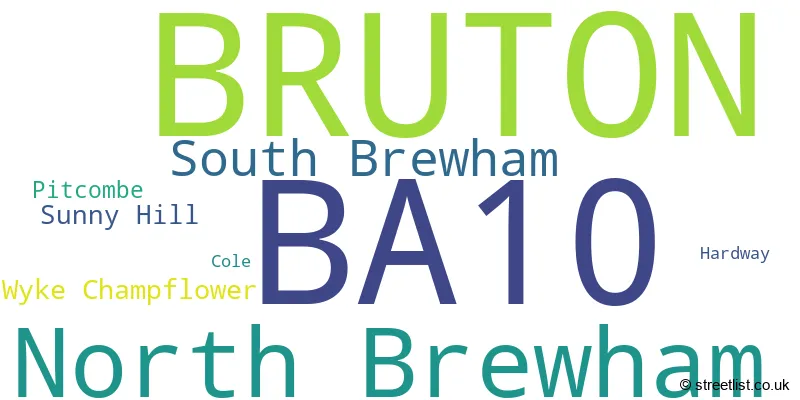
The largest settlement in the BA10 postal code is BRUTON followed by North Brewham, and South Brewham.
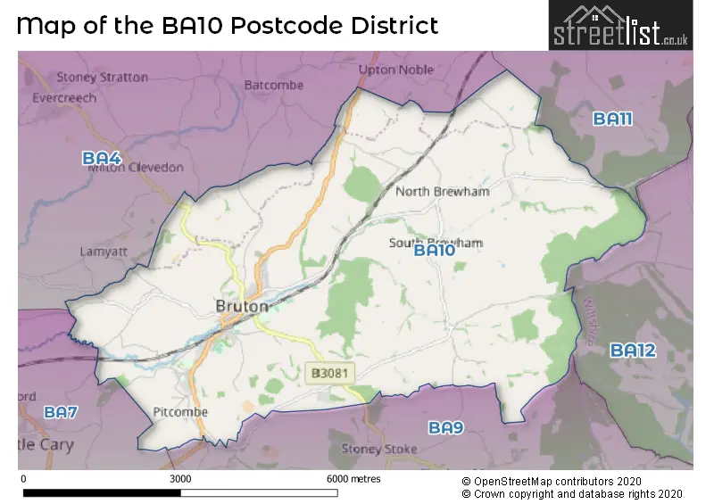
The BA10 Postcode shares a border with BA9 (WINCANTON, Charlton Musgrove, Pen Selwood), BA4 (SHEPTON MALLET, Evercreech, Pilton), BA7 (CASTLE CARY, Ansford, Lovington) and BA12 (WARMINSTER, Mere, Codford).
The primary settlement in the BA10 postcode district is Bruton, which is located in the county of Somerset in England. Other significant settlements within the BA10 postcode district include Cole, Hardway, North Brewham, Pitcombe, South Brewham, Sunny Hill, and Wyke Champflower, all of which are also located in Somerset. The most significant post town in the BA10 postcode district is Bruton.
For the district BA10, we have data on 1 postcode sectors. Here's a breakdown: The sector BA10 0, covers Bruton in Somerset.
BA10 Postcode Sectors

Map of the BA10 Postcode District
Explore the BA10 postcode district by using our free interactive map.
When it comes to local government, postal geography often disregards political borders. However, for a breakdown in the BA10 District: the district mostly encompasses the Somerset area with a total of 179 postcodes.
Weather Forecast for BA10
Press Button to Show Forecast for Stourhead
| Time Period | Icon | Description | Temperature | Rain Probability | Wind |
|---|---|---|---|---|---|
| 06:00 to 09:00 | Cloudy | 8.0°C (feels like 5.0°C) | 5.00% | WNW 11 mph | |
| 09:00 to 12:00 | Cloudy | 10.0°C (feels like 7.0°C) | 10.00% | NW 16 mph | |
| 12:00 to 15:00 | Overcast | 11.0°C (feels like 8.0°C) | 9.00% | NW 16 mph | |
| 15:00 to 18:00 | Cloudy | 12.0°C (feels like 9.0°C) | 6.00% | NNW 16 mph | |
| 18:00 to 21:00 | Partly cloudy (day) | 10.0°C (feels like 8.0°C) | 1.00% | N 11 mph | |
| 21:00 to 00:00 | Clear night | 7.0°C (feels like 4.0°C) | 1.00% | N 9 mph |
Press Button to Show Forecast for Stourhead
| Time Period | Icon | Description | Temperature | Rain Probability | Wind |
|---|---|---|---|---|---|
| 00:00 to 03:00 | Clear night | 4.0°C (feels like 2.0°C) | 1.00% | N 7 mph | |
| 03:00 to 06:00 | Partly cloudy (night) | 3.0°C (feels like 0.0°C) | 1.00% | NNE 7 mph | |
| 06:00 to 09:00 | Sunny day | 4.0°C (feels like 1.0°C) | 2.00% | NNE 7 mph | |
| 09:00 to 12:00 | Sunny day | 7.0°C (feels like 5.0°C) | 2.00% | NNE 7 mph | |
| 12:00 to 15:00 | Cloudy | 9.0°C (feels like 7.0°C) | 6.00% | NNE 9 mph | |
| 15:00 to 18:00 | Cloudy | 10.0°C (feels like 8.0°C) | 6.00% | NNE 9 mph | |
| 18:00 to 21:00 | Sunny day | 9.0°C (feels like 7.0°C) | 2.00% | NNE 7 mph | |
| 21:00 to 00:00 | Clear night | 5.0°C (feels like 3.0°C) | 2.00% | NE 7 mph |
Press Button to Show Forecast for Stourhead
| Time Period | Icon | Description | Temperature | Rain Probability | Wind |
|---|---|---|---|---|---|
| 00:00 to 03:00 | Clear night | 3.0°C (feels like 1.0°C) | 2.00% | ENE 4 mph | |
| 03:00 to 06:00 | Clear night | 3.0°C (feels like 0.0°C) | 1.00% | NE 4 mph | |
| 06:00 to 09:00 | Sunny day | 4.0°C (feels like 1.0°C) | 1.00% | NNE 7 mph | |
| 09:00 to 12:00 | Partly cloudy (day) | 8.0°C (feels like 6.0°C) | 1.00% | NNE 9 mph | |
| 12:00 to 15:00 | Overcast | 10.0°C (feels like 8.0°C) | 8.00% | NNE 11 mph | |
| 15:00 to 18:00 | Overcast | 11.0°C (feels like 8.0°C) | 9.00% | NNE 11 mph | |
| 18:00 to 21:00 | Overcast | 10.0°C (feels like 7.0°C) | 9.00% | NNE 9 mph | |
| 21:00 to 00:00 | Partly cloudy (night) | 7.0°C (feels like 4.0°C) | 2.00% | NNE 9 mph |
Press Button to Show Forecast for Stourhead
| Time Period | Icon | Description | Temperature | Rain Probability | Wind |
|---|---|---|---|---|---|
| 00:00 to 03:00 | Clear night | 5.0°C (feels like 2.0°C) | 2.00% | NE 9 mph | |
| 03:00 to 06:00 | Clear night | 4.0°C (feels like 1.0°C) | 2.00% | NNE 9 mph | |
| 06:00 to 09:00 | Partly cloudy (day) | 4.0°C (feels like 0.0°C) | 1.00% | NNE 9 mph | |
| 09:00 to 12:00 | Partly cloudy (day) | 8.0°C (feels like 5.0°C) | 2.00% | NE 11 mph | |
| 12:00 to 15:00 | Cloudy | 10.0°C (feels like 8.0°C) | 7.00% | NE 11 mph | |
| 15:00 to 18:00 | Cloudy | 11.0°C (feels like 8.0°C) | 8.00% | NNE 13 mph | |
| 18:00 to 21:00 | Partly cloudy (day) | 9.0°C (feels like 7.0°C) | 4.00% | NE 11 mph | |
| 21:00 to 00:00 | Partly cloudy (night) | 6.0°C (feels like 3.0°C) | 3.00% | NNE 11 mph |
Where is the BA10 Postcode District?
The postcode district BA10 is located in the town of Bruton. It is nearby various towns, including Wincanton to the south (4.59 miles), Castle Cary to the southwest (5.15 miles), Shepton Mallet to the northwest (6.73 miles), Gillingham to the southeast (8.00 miles), Frome to the north (8.97 miles), and Warminster to the northeast (11.87 miles). Additionally, the distance to London from BA10 is approximately 102.87 miles.
The district is within the post town of BRUTON.
The sector has postcodes within the nation of England.
The BA10 Postcode District is in the Somerset region of Dorset and Somerset within the South West (England).
Postcode Sectors within the BA10 District
| Postcode Sector | Delivery Office |
|---|---|
| BA10 0 | Bruton Scale Payment Delivery Office |
| B | A | 1 | 0 | - | X | X | X |
| B | A | 1 | 0 | Space | Numeric | Letter | Letter |
Current Monthly Rental Prices
| # Bedrooms | Min Price | Max Price | Avg Price |
|---|---|---|---|
| 1 | £750 | £750 | £750 |
| 2 | £1,100 | £1,100 | £1,100 |
Current House Prices
| # Bedrooms | Min Price | Max Price | Avg Price |
|---|---|---|---|
| £150,000 | £2,000,000 | £1,150,000 | |
| 2 | £249,950 | £250,000 | £249,975 |
| 3 | £275,000 | £1,350,000 | £588,125 |
| 4 | £530,000 | £3,500,000 | £991,429 |
| 5 | £475,000 | £1,295,000 | £836,250 |
Estate Agents who Operate in the BA10 District
| Logo | Name | Brand Name | Address | Contact Number | Total Properties |
|---|---|---|---|---|---|
 | Bruton | Lodestone Property | Bruton, Somerset | 01749 605099 | 7 |
 | Bruton | Hunter French | 9 High Street, Bruton, BA10 0AB | 01749 608422 | 6 |
 | Taunton | Carter Jonas Rural | The Quad, Blackbrook Park Avenue, Taunton, TA1 2PX | 01823 212368 | 4 |
 | Wincanton | Hambledon Estate Agents | 19 High Street Wincanton BA9 9JT | 01963 401477 | 2 |
 | Frome | lettings-r-us | 8 Harris Close, Frome, BA11 5JY | 01373 485186 | 1 |
| Type of Property | 2018 Average | 2018 Sales | 2017 Average | 2017 Sales | 2016 Average | 2016 Sales | 2015 Average | 2015 Sales |
|---|---|---|---|---|---|---|---|---|
| Detached | £395,194 | 18 | £441,786 | 28 | £391,048 | 20 | £465,426 | 17 |
| Semi-Detached | £231,786 | 7 | £269,700 | 10 | £233,803 | 13 | £239,243 | 10 |
| Terraced | £230,977 | 26 | £295,105 | 15 | £272,917 | 18 | £250,522 | 23 |
| Flats | £178,857 | 7 | £121,500 | 3 | £128,313 | 8 | £85,700 | 5 |
Hotels within the Postcode Area
We found 2 hotels and guest houses within the BA10 postcode area