The BA2 0 postcode sector is within the county of Somerset.
Did you know? According to the 2021 Census, the BA2 0 postcode sector is home to a bustling 4,878 residents!
Given that each sector allows for 400 unique postcode combinations. Letters C, I, K, M, O and V are not allowed in the last two letters of a postcode. With 191 postcodes already in use, this leaves 209 units available.
The largest settlement in the BA2 0 postal code is Timsbury followed by Farmborough, and Camerton.
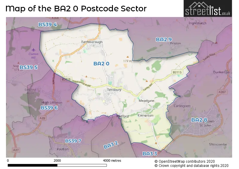
The BA2 0 Postcode shares a border with BA2 8 (Peasedown St. John, Wellow, Shoscombe), BA2 9 (Corston, Marksbury, Newton St. Loe), BA3 2 (Midsomer Norton, RADSTOCK), BA3 3 (RADSTOCK, Westfield, Writhlington), BS39 5 (Clutton, Temple Cloud, Bishop Sutton), BS39 6 (High Littleton, Farrington Gurney, Hallatrow), BS39 7 (Paulton) and BS39 4 (Pensford, Stanton Drew, Compton Dando).
The sector is within the post town of BATH.
BA2 0 is a postcode sector within the BA2 postcode district which is within the BA Bath postcode area.
The Royal Mail delivery office for the BA2 0 postal sector is the Bath Delivery Office.
The area of the BA2 0 postcode sector is 6.72 square miles which is 17.42 square kilometres or 4,303.78 square acres.
Waterways within the BA2 0 postcode sector include the Cam Brook.

Map of the BA2 0 Postcode Sector
Explore the BA2 0 postcode sector by using our free interactive map.
| B | A | 2 | - | 0 | X | X |
| B | A | 2 | Space | 0 | Letter | Letter |
Official List of Streets
Timsbury (52 Streets)
Farmborough (25 Streets)
Camerton (18 Streets)
Unofficial Streets or Alternative Spellings
Dunkerton
TUNLEY ROADRADSTOCK
EASTDOWN ROAD NORTHDOWN ROADPaulton
BATH ROADHigh Littleton
NEW ROADWeather Forecast for BA2 0
Press Button to Show Forecast for Radstock
| Time Period | Icon | Description | Temperature | Rain Probability | Wind |
|---|---|---|---|---|---|
| 12:00 to 15:00 | Cloudy | 11.0°C (feels like 9.0°C) | 34.00% | WNW 9 mph | |
| 15:00 to 18:00 | Cloudy | 12.0°C (feels like 10.0°C) | 8.00% | WNW 9 mph | |
| 18:00 to 21:00 | Cloudy | 10.0°C (feels like 9.0°C) | 5.00% | NW 7 mph | |
| 21:00 to 00:00 | Cloudy | 8.0°C (feels like 6.0°C) | 7.00% | NE 7 mph |
Press Button to Show Forecast for Radstock
| Time Period | Icon | Description | Temperature | Rain Probability | Wind |
|---|---|---|---|---|---|
| 00:00 to 03:00 | Cloudy | 7.0°C (feels like 5.0°C) | 8.00% | ENE 4 mph | |
| 03:00 to 06:00 | Cloudy | 6.0°C (feels like 4.0°C) | 9.00% | E 4 mph | |
| 06:00 to 09:00 | Cloudy | 6.0°C (feels like 4.0°C) | 8.00% | E 7 mph | |
| 09:00 to 12:00 | Cloudy | 8.0°C (feels like 5.0°C) | 10.00% | E 9 mph | |
| 12:00 to 15:00 | Overcast | 10.0°C (feels like 7.0°C) | 16.00% | E 9 mph | |
| 15:00 to 18:00 | Overcast | 10.0°C (feels like 8.0°C) | 22.00% | E 9 mph | |
| 18:00 to 21:00 | Cloudy | 9.0°C (feels like 7.0°C) | 18.00% | E 7 mph | |
| 21:00 to 00:00 | Cloudy | 7.0°C (feels like 5.0°C) | 15.00% | E 7 mph |
Press Button to Show Forecast for Radstock
| Time Period | Icon | Description | Temperature | Rain Probability | Wind |
|---|---|---|---|---|---|
| 00:00 to 03:00 | Cloudy | 6.0°C (feels like 4.0°C) | 20.00% | ENE 7 mph | |
| 03:00 to 06:00 | Light rain | 6.0°C (feels like 3.0°C) | 49.00% | ENE 9 mph | |
| 06:00 to 09:00 | Light rain | 6.0°C (feels like 3.0°C) | 53.00% | ENE 9 mph | |
| 09:00 to 12:00 | Light rain | 8.0°C (feels like 5.0°C) | 50.00% | ENE 11 mph | |
| 12:00 to 15:00 | Overcast | 10.0°C (feels like 8.0°C) | 20.00% | ENE 11 mph | |
| 15:00 to 18:00 | Light rain | 11.0°C (feels like 9.0°C) | 50.00% | ENE 11 mph | |
| 18:00 to 21:00 | Light rain | 10.0°C (feels like 8.0°C) | 53.00% | ENE 11 mph | |
| 21:00 to 00:00 | Light rain | 9.0°C (feels like 6.0°C) | 50.00% | ENE 11 mph |
Press Button to Show Forecast for Radstock
| Time Period | Icon | Description | Temperature | Rain Probability | Wind |
|---|---|---|---|---|---|
| 00:00 to 03:00 | Light rain | 8.0°C (feels like 5.0°C) | 51.00% | NE 9 mph | |
| 03:00 to 06:00 | Light rain | 7.0°C (feels like 5.0°C) | 53.00% | NE 9 mph | |
| 06:00 to 09:00 | Heavy rain | 8.0°C (feels like 5.0°C) | 74.00% | NE 9 mph | |
| 09:00 to 12:00 | Heavy rain shower (day) | 9.0°C (feels like 7.0°C) | 54.00% | E 11 mph | |
| 12:00 to 15:00 | Heavy rain shower (day) | 11.0°C (feels like 8.0°C) | 56.00% | WSW 11 mph | |
| 15:00 to 18:00 | Light rain shower (day) | 11.0°C (feels like 9.0°C) | 40.00% | NNW 11 mph | |
| 18:00 to 21:00 | Light rain shower (day) | 11.0°C (feels like 9.0°C) | 34.00% | N 9 mph | |
| 21:00 to 00:00 | Partly cloudy (night) | 8.0°C (feels like 6.0°C) | 6.00% | NNW 7 mph |
House Prices in the BA2 0 Postcode Sector
| Type of Property | 2018 Average | 2018 Sales | 2017 Average | 2017 Sales | 2016 Average | 2016 Sales | 2015 Average | 2015 Sales |
|---|---|---|---|---|---|---|---|---|
| Detached | £436,448 | 29 | £426,378 | 29 | £405,636 | 36 | £340,028 | 32 |
| Semi-Detached | £298,654 | 27 | £256,465 | 26 | £254,614 | 18 | £261,687 | 26 |
| Terraced | £270,633 | 21 | £301,191 | 17 | £239,534 | 30 | £206,448 | 37 |
| Flats | £230,000 | 1 | £95,000 | 1 | £0 | 0 | £154,167 | 3 |
Important Postcodes BA2 0 in the Postcode Sector
BA2 0FY is the postcode for Farmborough VC Primary School, The Street, and Farmborough Church School, The Street, Farmborough
BA2 0HX is the postcode for St. Marys Surgery, St. Marys Close
BA2 0JR is the postcode for St. Marys C of E VC Primary School, Lansdown View, and St Marys CofE Primary School, Lansdown View, Timsbury
| The BA2 0 Sector is within these Local Authorities |
|
|---|---|
| The BA2 0 Sector is within these Counties |
|
| The BA2 0 Sector is within these Water Company Areas |
|