The BB11 4 postcode sector is within the county of Lancashire.
Did you know? According to the 2021 Census, the BB11 4 postcode sector is home to a bustling 6,910 residents!
Given that each sector allows for 400 unique postcode combinations. Letters C, I, K, M, O and V are not allowed in the last two letters of a postcode. With 171 postcodes already in use, this leaves 229 units available.
The BB11 4 postal code covers the settlement of BURNLEY.
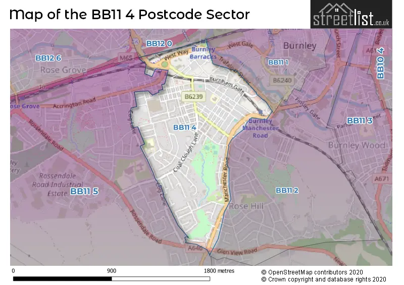
The BB11 4 Postcode shares a border with BB12 0 (BURNLEY), BB11 1 (BURNLEY), BB11 2 (BURNLEY) and BB11 5 (BURNLEY, Hapton, Dunnockshaw).
The sector is within the post town of BURNLEY.
BB11 4 is a postcode sector within the BB11 postcode district which is within the BB Blackburn postcode area.
The Royal Mail delivery office for the BB11 4 postal sector is the Burnley Delivery Office.
The area of the BB11 4 postcode sector is 0.51 square miles which is 1.33 square kilometres or 327.46 square acres.
The BB11 4 postcode sector is crossed by the M65 motorway.
Waterways within the BB11 4 postcode sector include the Leeds and Liverpool Canal.

Map of the BB11 4 Postcode Sector
Explore the BB11 4 postcode sector by using our free interactive map.
| B | B | 1 | 1 | - | 4 | X | X |
| B | B | 1 | 1 | Space | 4 | Letter | Letter |
Official List of Streets
BURNLEY (119 Streets)
Burnham Trading Park (2 Streets)
Unofficial Streets or Alternative Spellings
BURNLEY
CLEVELANDS ROAD COG LANE FIELDEN STREET GAINSBOROUGH AVENUE GLEN VIEW ROAD HEALEY MOUNT JUNCTION STREET MYRTLE AVENUE PADIHAM ROAD RAEBURN AVENUE REYNOLDS STREET ROMNEY AVENUE ROSEHILL AVENUE ROSEMOUNT AVENUE ROSEWOOD AVENUE ROSSENDALE ROAD SANDYGATE TRAFALGAR STREET VENICE AVENUE WESTGATE BAILEY STREET BUCK STREET BURNLEY BARRACKS INTERCHANGE CAVALRY WAY CRANMER STREET HAMELDON APPROACH KEPPEL PLACE PALM STREET PARKLAND VIEW PERTH STREET RIDING STREET SPRING HILL ROAD STARKIE STREET STOOP STREET SUBWAY TENNYSON STREET THORNEY BANK STREET WESTWAY WHITEHAVEN STREETHapton
ACCRINGTON ROADWeather Forecast for BB11 4
Press Button to Show Forecast for Burnley
| Time Period | Icon | Description | Temperature | Rain Probability | Wind |
|---|---|---|---|---|---|
| 06:00 to 09:00 | Partly cloudy (day) | 4.0°C (feels like 3.0°C) | 0.00% | WNW 4 mph | |
| 09:00 to 12:00 | Partly cloudy (day) | 8.0°C (feels like 5.0°C) | 1.00% | NNE 9 mph | |
| 12:00 to 15:00 | Partly cloudy (day) | 10.0°C (feels like 8.0°C) | 1.00% | NNE 9 mph | |
| 15:00 to 18:00 | Cloudy | 11.0°C (feels like 9.0°C) | 4.00% | NNE 9 mph | |
| 18:00 to 21:00 | Cloudy | 9.0°C (feels like 7.0°C) | 4.00% | NE 9 mph | |
| 21:00 to 00:00 | Cloudy | 7.0°C (feels like 5.0°C) | 5.00% | NE 4 mph |
Press Button to Show Forecast for Burnley
| Time Period | Icon | Description | Temperature | Rain Probability | Wind |
|---|---|---|---|---|---|
| 00:00 to 03:00 | Cloudy | 5.0°C (feels like 3.0°C) | 9.00% | NNE 4 mph | |
| 03:00 to 06:00 | Overcast | 4.0°C (feels like 3.0°C) | 8.00% | NNE 4 mph | |
| 06:00 to 09:00 | Partly cloudy (day) | 4.0°C (feels like 3.0°C) | 3.00% | NE 4 mph | |
| 09:00 to 12:00 | Cloudy | 7.0°C (feels like 5.0°C) | 6.00% | NNE 9 mph | |
| 12:00 to 15:00 | Overcast | 9.0°C (feels like 6.0°C) | 10.00% | NNE 9 mph | |
| 15:00 to 18:00 | Overcast | 9.0°C (feels like 7.0°C) | 9.00% | NNE 9 mph | |
| 18:00 to 21:00 | Partly cloudy (day) | 8.0°C (feels like 5.0°C) | 5.00% | NNE 9 mph | |
| 21:00 to 00:00 | Cloudy | 5.0°C (feels like 3.0°C) | 6.00% | NNE 7 mph |
Press Button to Show Forecast for Burnley
| Time Period | Icon | Description | Temperature | Rain Probability | Wind |
|---|---|---|---|---|---|
| 00:00 to 03:00 | Clear night | 3.0°C (feels like 1.0°C) | 2.00% | NNE 4 mph | |
| 03:00 to 06:00 | Cloudy | 3.0°C (feels like 1.0°C) | 6.00% | NNE 4 mph | |
| 06:00 to 09:00 | Partly cloudy (day) | 4.0°C (feels like 2.0°C) | 2.00% | NNW 4 mph | |
| 09:00 to 12:00 | Cloudy | 7.0°C (feels like 5.0°C) | 6.00% | N 7 mph | |
| 12:00 to 15:00 | Overcast | 9.0°C (feels like 7.0°C) | 11.00% | N 7 mph | |
| 15:00 to 18:00 | Cloudy | 9.0°C (feels like 8.0°C) | 13.00% | NNW 7 mph | |
| 18:00 to 21:00 | Partly cloudy (day) | 8.0°C (feels like 7.0°C) | 8.00% | N 7 mph | |
| 21:00 to 00:00 | Cloudy | 6.0°C (feels like 4.0°C) | 7.00% | NE 4 mph |
Press Button to Show Forecast for Burnley
| Time Period | Icon | Description | Temperature | Rain Probability | Wind |
|---|---|---|---|---|---|
| 00:00 to 03:00 | Cloudy | 4.0°C (feels like 3.0°C) | 8.00% | E 4 mph | |
| 03:00 to 06:00 | Cloudy | 4.0°C (feels like 2.0°C) | 10.00% | E 4 mph | |
| 06:00 to 09:00 | Cloudy | 5.0°C (feels like 4.0°C) | 11.00% | NNE 4 mph | |
| 09:00 to 12:00 | Cloudy | 8.0°C (feels like 6.0°C) | 12.00% | SE 7 mph | |
| 12:00 to 15:00 | Cloudy | 9.0°C (feels like 8.0°C) | 14.00% | NE 7 mph | |
| 15:00 to 18:00 | Cloudy | 10.0°C (feels like 8.0°C) | 13.00% | SSW 7 mph | |
| 18:00 to 21:00 | Partly cloudy (day) | 9.0°C (feels like 8.0°C) | 11.00% | WSW 7 mph | |
| 21:00 to 00:00 | Cloudy | 7.0°C (feels like 5.0°C) | 13.00% | E 4 mph |
Schools and Places of Education Within the BB11 4 Postcode Sector
Burnley Holy Trinity Church of England Primary School
Voluntary aided school
Raglan Road, Burnley, Lancashire, BB11 4LB
Head: Mrs Alison Whitaker
Ofsted Rating: Good
Inspection: 2022-10-20 (551 days ago)
Website: Visit Burnley Holy Trinity Church of England Primary School Website
Phone: 01282434368
Number of Pupils: 208
Coal Clough Academy
Academy alternative provision sponsor led
Swindon Street, Burnley, Lancashire, BB11 4PF
Head: Mrs Holly Clarke
Ofsted Rating: Good
Inspection: 2018-06-15 (2139 days ago)
Website: Visit Coal Clough Academy Website
Phone: 01282421142
Number of Pupils: 100
The Rose School
Community special school
Greenock Street, Burnley, Lancashire, BB11 4DT
Head: Mrs Helen Dunbavin
Ofsted Rating: Requires improvement
Inspection: 2022-05-25 (699 days ago)
Website: Visit The Rose School Website
Phone: 01282683050
Number of Pupils: 66
House Prices in the BB11 4 Postcode Sector
| Type of Property | 2018 Average | 2018 Sales | 2017 Average | 2017 Sales | 2016 Average | 2016 Sales | 2015 Average | 2015 Sales |
|---|---|---|---|---|---|---|---|---|
| Detached | £187,623 | 12 | £178,914 | 6 | £122,597 | 5 | £201,375 | 8 |
| Semi-Detached | £127,228 | 40 | £118,774 | 47 | £121,636 | 37 | £118,783 | 28 |
| Terraced | £59,505 | 179 | £54,326 | 132 | £52,160 | 127 | £46,470 | 124 |
| Flats | £59,071 | 7 | £74,562 | 8 | £0 | 0 | £47,400 | 5 |
Important Postcodes BB11 4 in the Postcode Sector
BB11 4BA is the postcode for Burnley & Pendle Personalised Curriculum Support Service, Hargher Clough Site, Venice Street, Stoops Hargher Clough Community Centre, Venice Street, and Hargher Clough Site, Venice Street
BB11 4BU is the postcode for Sure Start South West Burnley, 21 Tay Street
BB11 4DT is the postcode for The Rose School, Greenock Street, and Burnley Pendle & Rossendale Short Breaks Services, Haddon House, Greenock Street
BB11 4LB is the postcode for Holy Trinity C of E School, Raglan Road
BB11 4NW is the postcode for Coal Clough Library, Lancashire County Council, Coal Clough Lane, and Lancashire County Council, Library, Coal Clough Lane
BB11 4PF is the postcode for HILLVIEW BUILDING, Coal Clough High School, Swindon Street, The Rose School, Swindon Street, Coal Clough High School, Swindon Street, MAIN, Coal Clough High School, Swindon Street, and VOCATIONAL, Coal Clough High School, Swindon Street
BB11 4PQ is the postcode for Howard Street Community Health Centre, Howard Street
BB11 4RB is the postcode for Christ the King RC Primary School, Calderbrook Avenue
BB11 4SD is the postcode for VANGUARD COMMUNITY CENTRE, 65, Bevington Close
| The BB11 4 Sector is within these Local Authorities |
|
|---|---|
| The BB11 4 Sector is within these Counties |
|
| The BB11 4 Sector is within these Water Company Areas |
|