The BB12 9 postcode sector is within the county of Lancashire.
Did you know? According to the 2021 Census, the BB12 9 postcode sector is home to a bustling 3,297 residents!
Given that each sector allows for 400 unique postcode combinations. Letters C, I, K, M, O and V are not allowed in the last two letters of a postcode. With 156 postcodes already in use, this leaves 244 units available.
The largest settlement in the BB12 9 postal code is Fence followed by Higham, and Newchurch-in-Pendle.
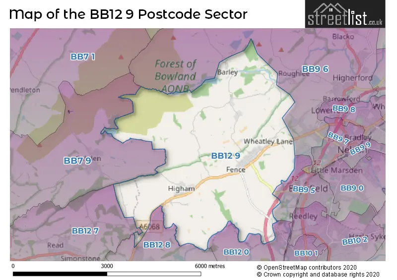
The BB12 9 Postcode shares a border with BB7 9 (Whalley, Barrow, Billington), BB9 5 (Brierfield), BB9 6 (Barrowford, Blacko, Roughlee), BB12 7 (Padiham, Hapton, Read), BB12 8 (Padiham, BURNLEY) and BB12 0 (BURNLEY).
The sector is within the post town of BURNLEY.
BB12 9 is a postcode sector within the BB12 postcode district which is within the BB Blackburn postcode area.
The Royal Mail delivery office for the BB12 9 postal sector is the Burnley Delivery Office.
The area of the BB12 9 postcode sector is 9.53 square miles which is 24.69 square kilometres or 6,100.71 square acres.
Waterways within the BB12 9 postcode sector include the Pendle Water, River Calder, Ogden Clough.

Map of the BB12 9 Postcode Sector
Explore the BB12 9 postcode sector by using our free interactive map.
| B | B | 1 | 2 | - | 9 | X | X |
| B | B | 1 | 2 | Space | 9 | Letter | Letter |
Official List of Streets
Higham (30 Streets)
Barley (5 Streets)
Roughlee (6 Streets)
Fence (32 Streets)
Padiham (6 Streets)
Newchurch-in-Pendle (10 Streets)
Reedley (4 Streets)
BURNLEY (1 Streets)
Unofficial Streets or Alternative Spellings
Weather Forecast for BB12 9
Press Button to Show Forecast for Brierfield
| Time Period | Icon | Description | Temperature | Rain Probability | Wind |
|---|---|---|---|---|---|
| 18:00 to 21:00 | Partly cloudy (day) | 8.0°C (feels like 5.0°C) | 1.00% | WNW 11 mph | |
| 21:00 to 00:00 | Partly cloudy (night) | 5.0°C (feels like 3.0°C) | 0.00% | W 7 mph |
Press Button to Show Forecast for Brierfield
| Time Period | Icon | Description | Temperature | Rain Probability | Wind |
|---|---|---|---|---|---|
| 00:00 to 03:00 | Cloudy | 5.0°C (feels like 2.0°C) | 4.00% | WSW 7 mph | |
| 03:00 to 06:00 | Cloudy | 4.0°C (feels like 2.0°C) | 5.00% | WSW 4 mph | |
| 06:00 to 09:00 | Cloudy | 5.0°C (feels like 3.0°C) | 4.00% | WSW 4 mph | |
| 09:00 to 12:00 | Cloudy | 7.0°C (feels like 5.0°C) | 10.00% | N 7 mph | |
| 12:00 to 15:00 | Cloudy | 8.0°C (feels like 7.0°C) | 7.00% | NNW 7 mph | |
| 15:00 to 18:00 | Cloudy | 9.0°C (feels like 7.0°C) | 7.00% | N 7 mph | |
| 18:00 to 21:00 | Cloudy | 7.0°C (feels like 5.0°C) | 10.00% | NE 9 mph | |
| 21:00 to 00:00 | Cloudy | 5.0°C (feels like 3.0°C) | 7.00% | ENE 7 mph |
Press Button to Show Forecast for Brierfield
| Time Period | Icon | Description | Temperature | Rain Probability | Wind |
|---|---|---|---|---|---|
| 00:00 to 03:00 | Clear night | 3.0°C (feels like 1.0°C) | 2.00% | ENE 4 mph | |
| 03:00 to 06:00 | Clear night | 1.0°C (feels like -1.0°C) | 1.00% | NE 4 mph | |
| 06:00 to 09:00 | Partly cloudy (day) | 3.0°C (feels like 1.0°C) | 2.00% | NE 4 mph | |
| 09:00 to 12:00 | Overcast | 7.0°C (feels like 5.0°C) | 8.00% | E 7 mph | |
| 12:00 to 15:00 | Cloudy | 8.0°C (feels like 7.0°C) | 7.00% | E 4 mph | |
| 15:00 to 18:00 | Cloudy | 9.0°C (feels like 8.0°C) | 6.00% | ENE 4 mph | |
| 18:00 to 21:00 | Cloudy | 8.0°C (feels like 6.0°C) | 8.00% | ENE 7 mph | |
| 21:00 to 00:00 | Cloudy | 5.0°C (feels like 3.0°C) | 5.00% | ENE 7 mph |
Press Button to Show Forecast for Brierfield
| Time Period | Icon | Description | Temperature | Rain Probability | Wind |
|---|---|---|---|---|---|
| 00:00 to 03:00 | Partly cloudy (night) | 4.0°C (feels like 1.0°C) | 5.00% | ENE 7 mph | |
| 03:00 to 06:00 | Cloudy | 3.0°C (feels like 1.0°C) | 8.00% | ENE 7 mph | |
| 06:00 to 09:00 | Partly cloudy (day) | 4.0°C (feels like 2.0°C) | 6.00% | ENE 7 mph | |
| 09:00 to 12:00 | Cloudy | 7.0°C (feels like 5.0°C) | 9.00% | E 9 mph | |
| 12:00 to 15:00 | Overcast | 9.0°C (feels like 7.0°C) | 14.00% | E 9 mph | |
| 15:00 to 18:00 | Overcast | 9.0°C (feels like 7.0°C) | 17.00% | E 9 mph | |
| 18:00 to 21:00 | Cloudy | 9.0°C (feels like 6.0°C) | 16.00% | ENE 11 mph | |
| 21:00 to 00:00 | Cloudy | 6.0°C (feels like 3.0°C) | 15.00% | ENE 9 mph |
Press Button to Show Forecast for Brierfield
| Time Period | Icon | Description | Temperature | Rain Probability | Wind |
|---|---|---|---|---|---|
| 00:00 to 03:00 | Cloudy | 5.0°C (feels like 3.0°C) | 15.00% | NE 9 mph | |
| 03:00 to 06:00 | Cloudy | 6.0°C (feels like 3.0°C) | 14.00% | NE 9 mph | |
| 06:00 to 09:00 | Cloudy | 6.0°C (feels like 4.0°C) | 17.00% | NE 9 mph | |
| 09:00 to 12:00 | Heavy rain | 8.0°C (feels like 6.0°C) | 72.00% | ENE 9 mph | |
| 12:00 to 15:00 | Light rain | 10.0°C (feels like 8.0°C) | 55.00% | NE 9 mph | |
| 15:00 to 18:00 | Heavy rain | 10.0°C (feels like 8.0°C) | 78.00% | NE 9 mph | |
| 18:00 to 21:00 | Light rain shower (day) | 10.0°C (feels like 8.0°C) | 39.00% | N 9 mph | |
| 21:00 to 00:00 | Partly cloudy (night) | 7.0°C (feels like 5.0°C) | 16.00% | SE 7 mph |
Schools and Places of Education Within the BB12 9 Postcode Sector
Higham St John's Church of England Primary School
Voluntary controlled school
Higham Hall Road, Burnley, Lancashire, BB12 9EU
Head: Mrs Helen Shaw
Ofsted Rating: Good
Inspection: 2021-09-15 (952 days ago)
Website: Visit Higham St John's Church of England Primary School Website
Phone: 01282772376
Number of Pupils: 137
Newchurch-In-Pendle St Mary's Church of England Primary School
Academy sponsor led
Spenbrook Road, Burnley, Lancashire, BB12 9JP
Head: Mrs Pauline Nightingale
Ofsted Rating: Good
Inspection: 2020-01-15 (1561 days ago)
Website: Visit Newchurch-In-Pendle St Mary's Church of England Primary School Website
Phone: 01282612191
Number of Pupils: 54
House Prices in the BB12 9 Postcode Sector
| Type of Property | 2018 Average | 2018 Sales | 2017 Average | 2017 Sales | 2016 Average | 2016 Sales | 2015 Average | 2015 Sales |
|---|---|---|---|---|---|---|---|---|
| Detached | £368,000 | 16 | £334,132 | 25 | £285,643 | 21 | £372,077 | 13 |
| Semi-Detached | £255,690 | 10 | £257,088 | 12 | £240,585 | 17 | £238,875 | 16 |
| Terraced | £192,462 | 30 | £215,445 | 32 | £178,347 | 18 | £187,419 | 30 |
| Flats | £0 | 0 | £0 | 0 | £167,450 | 1 | £122,850 | 4 |
Important Postcodes BB12 9 in the Postcode Sector
BB12 9ED is the postcode for Wheatley Lane Methodist Aided School, Wheatley Lane Road, Fence, and Wheatley Lane Methodist Aided School, Wheatley Lane Road
BB12 9EU is the postcode for St. Johns Primary School, Higham Hall Road
BB12 9JP is the postcode for Newchurch St Mary's Church of England Academy, SPENBROOK ROAD, NEWCHURCH
| The BB12 9 Sector is within these Local Authorities |
|
|---|---|
| The BB12 9 Sector is within these Counties |
|
| The BB12 9 Sector is within these Water Company Areas |
|