The BB9 6 postcode sector is within the county of Lancashire.
Did you know? According to the 2021 Census, the BB9 6 postcode sector is home to a bustling 4,541 residents!
Given that each sector allows for 400 unique postcode combinations. Letters C, I, K, M, O and V are not allowed in the last two letters of a postcode. With 194 postcodes already in use, this leaves 206 units available.
The largest settlement in the BB9 6 postal code is Barrowford followed by Blacko, and Roughlee.
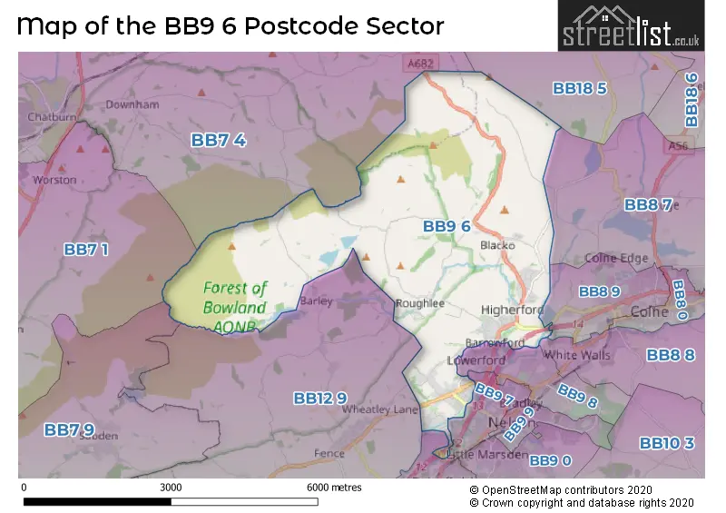
The BB9 6 Postcode shares a border with BB7 1 (CLITHEROE, Pendleton, Worston), BB7 4 (Chatburn, Gisburn, Bolton By Bowland), BB7 9 (Whalley, Barrow, Billington), BB8 7 (COLNE, Foulridge, Laneshawbridge), BB8 8 (COLNE, Trawden, Winewall), BB9 5 (Brierfield), BB9 7 (NELSON), BB9 8 (NELSON, Barrowford), BB12 9 (Fence, Higham, Newchurch-in-Pendle), BB8 9 (COLNE) and BB18 5 (BARNOLDSWICK, Salterforth).
The sector is within the post town of NELSON.
BB9 6 is a postcode sector within the BB9 postcode district which is within the BB Blackburn postcode area.
The Royal Mail delivery office for the BB9 6 postal sector is the Pendle Delivery Office.
The area of the BB9 6 postcode sector is 10.53 square miles which is 27.27 square kilometres or 6,737.64 square acres.
Waterways within the BB9 6 postcode sector include the Leeds and Liverpool Canal, Pendle Water, Ogden Clough.

Map of the BB9 6 Postcode Sector
Explore the BB9 6 postcode sector by using our free interactive map.
| B | B | 9 | - | 6 | X | X |
| B | B | 9 | Space | 6 | Letter | Letter |
Official List of Streets
Barrowford (104 Streets)
Blacko (13 Streets)
Barley (1 Streets)
Roughlee (8 Streets)
Unofficial Streets or Alternative Spellings
COLNE
GREENFIELD ROAD RED LANE BANK HOUSE STREET BARROWFORD LOCKS BRIDGE BARROWFORD ROAD BRIDGE BLACKO FOOT BRIDGE BRIERFIELD INTERCHANGE CARRSIDE FACTORY LANE HIGHERFORD BRIDGE KIRBY ROAD LISTER WELL ROAD PATH TO FOXS WELL PENDLESIDE PINFOLD RICHMOND ROAD SANDYHALL LANE VANTAGE COURT WARREN DRIVEBarrowford
BROADWAY PLACE BURNSALL PLACE HIGHER CAUSEWAY KINGSHOTTE GARDENS RIDGEWAYBrierfield
KENYON ROADNELSON
CARR ROAD TURNER ROADHigham
BARROWFORD ROADWeather Forecast for BB9 6
Press Button to Show Forecast for Colne
| Time Period | Icon | Description | Temperature | Rain Probability | Wind |
|---|---|---|---|---|---|
| 09:00 to 12:00 | Partly cloudy (day) | 7.0°C (feels like 4.0°C) | 0.00% | NNE 9 mph | |
| 12:00 to 15:00 | Cloudy | 9.0°C (feels like 7.0°C) | 4.00% | N 7 mph | |
| 15:00 to 18:00 | Partly cloudy (day) | 11.0°C (feels like 9.0°C) | 0.00% | NNW 7 mph | |
| 18:00 to 21:00 | Sunny day | 8.0°C (feels like 6.0°C) | 1.00% | NW 9 mph | |
| 21:00 to 00:00 | Cloudy | 5.0°C (feels like 3.0°C) | 4.00% | W 4 mph |
Press Button to Show Forecast for Colne
| Time Period | Icon | Description | Temperature | Rain Probability | Wind |
|---|---|---|---|---|---|
| 00:00 to 03:00 | Cloudy | 4.0°C (feels like 2.0°C) | 5.00% | W 7 mph | |
| 03:00 to 06:00 | Cloudy | 5.0°C (feels like 2.0°C) | 5.00% | WNW 7 mph | |
| 06:00 to 09:00 | Cloudy | 5.0°C (feels like 2.0°C) | 6.00% | NW 7 mph | |
| 09:00 to 12:00 | Overcast | 7.0°C (feels like 4.0°C) | 13.00% | NNW 9 mph | |
| 12:00 to 15:00 | Overcast | 8.0°C (feels like 6.0°C) | 10.00% | NNW 7 mph | |
| 15:00 to 18:00 | Cloudy | 8.0°C (feels like 7.0°C) | 8.00% | N 7 mph | |
| 18:00 to 21:00 | Cloudy | 7.0°C (feels like 5.0°C) | 6.00% | N 7 mph | |
| 21:00 to 00:00 | Partly cloudy (night) | 5.0°C (feels like 2.0°C) | 3.00% | ENE 7 mph |
Press Button to Show Forecast for Colne
| Time Period | Icon | Description | Temperature | Rain Probability | Wind |
|---|---|---|---|---|---|
| 00:00 to 03:00 | Partly cloudy (night) | 3.0°C (feels like 0.0°C) | 4.00% | ENE 4 mph | |
| 03:00 to 06:00 | Partly cloudy (night) | 2.0°C (feels like 0.0°C) | 6.00% | E 4 mph | |
| 06:00 to 09:00 | Cloudy | 3.0°C (feels like 1.0°C) | 7.00% | E 4 mph | |
| 09:00 to 12:00 | Cloudy | 6.0°C (feels like 3.0°C) | 12.00% | E 9 mph | |
| 12:00 to 15:00 | Overcast | 7.0°C (feels like 5.0°C) | 15.00% | E 7 mph | |
| 15:00 to 18:00 | Cloudy | 8.0°C (feels like 6.0°C) | 16.00% | E 7 mph | |
| 18:00 to 21:00 | Cloudy | 7.0°C (feels like 5.0°C) | 12.00% | E 9 mph | |
| 21:00 to 00:00 | Cloudy | 5.0°C (feels like 3.0°C) | 12.00% | E 9 mph |
Press Button to Show Forecast for Colne
| Time Period | Icon | Description | Temperature | Rain Probability | Wind |
|---|---|---|---|---|---|
| 00:00 to 03:00 | Cloudy | 4.0°C (feels like 1.0°C) | 16.00% | E 9 mph | |
| 03:00 to 06:00 | Cloudy | 4.0°C (feels like 1.0°C) | 17.00% | E 7 mph | |
| 06:00 to 09:00 | Cloudy | 4.0°C (feels like 1.0°C) | 19.00% | ENE 9 mph | |
| 09:00 to 12:00 | Cloudy | 6.0°C (feels like 3.0°C) | 19.00% | E 11 mph | |
| 12:00 to 15:00 | Overcast | 8.0°C (feels like 6.0°C) | 20.00% | E 11 mph | |
| 15:00 to 18:00 | Light rain | 9.0°C (feels like 6.0°C) | 46.00% | ENE 11 mph | |
| 18:00 to 21:00 | Cloudy | 8.0°C (feels like 6.0°C) | 17.00% | NE 9 mph | |
| 21:00 to 00:00 | Cloudy | 7.0°C (feels like 4.0°C) | 19.00% | NE 9 mph |
Schools and Places of Education Within the BB9 6 Postcode Sector
Barrowford School
Community school
Rushton Street, Nelson, Lancashire, BB9 6EA
Head: Mrs Rachel Tomlinson
Ofsted Rating: Good
Inspection: 2022-03-03 (783 days ago)
Website: Visit Barrowford School Website
Phone: 01282615644
Number of Pupils: 326
Barrowford St Thomas Church of England Primary School
Voluntary aided school
Wheatley Lane Road, Nelson, Lancashire, BB9 6QT
Head: Mrs Jo Duckworth
Ofsted Rating: Outstanding
Inspection: 2023-09-27 (210 days ago)
Website: Visit Barrowford St Thomas Church of England Primary School Website
Phone: 01282614462
Number of Pupils: 118
Blacko Primary School
Academy converter
Blacko Primary School, Gisburn Road, Nelson, Lancashire, BB9 6LS
Head: Mrs Kate Richards
Ofsted Rating: Good
Inspection: 2022-11-29 (512 days ago)
Website: Visit Blacko Primary School Website
Phone: 01282616669
Number of Pupils: 103
Roughlee Church of England Primary School
Voluntary controlled school
Blacko Bar Road, Nelson, Lancashire, BB9 6NX
Head: Mr Mark Elliott
Ofsted Rating: Good
Inspection: 2022-10-04 (568 days ago)
Website: Visit Roughlee Church of England Primary School Website
Phone: 01282613613
Number of Pupils: 50
House Prices in the BB9 6 Postcode Sector
| Type of Property | 2018 Average | 2018 Sales | 2017 Average | 2017 Sales | 2016 Average | 2016 Sales | 2015 Average | 2015 Sales |
|---|---|---|---|---|---|---|---|---|
| Detached | £357,848 | 27 | £363,375 | 20 | £386,107 | 14 | £292,731 | 32 |
| Semi-Detached | £245,216 | 16 | £225,000 | 20 | £241,450 | 18 | £213,229 | 12 |
| Terraced | £133,991 | 45 | £141,906 | 38 | £125,344 | 42 | £131,247 | 45 |
| Flats | £140,000 | 1 | £0 | 0 | £152,300 | 5 | £90,000 | 2 |
Important Postcodes BB9 6 in the Postcode Sector
BB9 6EA is the postcode for INFANT BUILDING BARROWFORD CP SCHOOL, Barrowford Cp School, Rushton Street, Barrowford Cp School, Rushton Street, and JUNIOR BUILDING BARROWFORD CP SCHOOL, Barrowford Cp School, Rushton Street
BB9 6LS is the postcode for Blacko Primary School, Gisburn Road
BB9 6QT is the postcode for Barrowford St. Thomas Church Of England Primary School, Wheatley Lane Road
| The BB9 6 Sector is within these Local Authorities |
|
|---|---|
| The BB9 6 Sector is within these Counties |
|
| The BB9 6 Sector is within these Water Company Areas |
|