The BD2 postcode district is a postal district located in the BD Bradford postcode area with a population of 31,563 residents according to the 2021 England and Wales Census.
The area of the BD2 postcode district is 2.50 square miles which is 6.47 square kilometres or 1,598.56 acres.
Currently, the BD2 district has about 703 postcode units spread across 28 geographic postcode sectors.
Given that each sector allows for 400 unique postcode combinations, the district has a capacity of 11,200 postcodes. With 703 postcodes already in use, this leaves 10497 units available.
The largest settlements in the BD2 postal code are BRADFORD and Eccleshill.
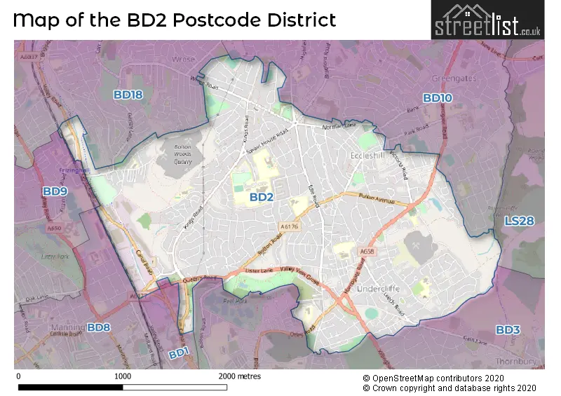
The BD2 Postcode shares a border with BD10 (BRADFORD, Idle, Thackley), BD18 (SHIPLEY), BD3 (BRADFORD, Thornbury) and BD9 (BRADFORD, Heaton, Daisy Hill).
The primary settlement in the BD2 postcode district is Bradford, which is located in the county of West Yorkshire, England. The most significant post town in this district is also Bradford. Additionally, Eccleshill and Five Lane Ends are other significant settlements within this postcode district.
For the district BD2, we have data on 4 postcode sectors. Here's a breakdown: The sector BD2 1, covers Bradford in West Yorkshire. The sector BD2 2, covers Bradford and Eccleshill in West Yorkshire. The sector BD2 3, covers Bradford in West Yorkshire. The sector BD2 4, covers Bradford in West Yorkshire.

Map of the BD2 Postcode District
Explore the BD2 postcode district by using our free interactive map.
When it comes to local government, postal geography often disregards political borders. However, for a breakdown in the BD2 District: the district mostly encompasses the Bradford District (B) area with a total of 723 postcodes.
Weather Forecast for BD2
Press Button to Show Forecast for Undercliffe
| Time Period | Icon | Description | Temperature | Rain Probability | Wind |
|---|---|---|---|---|---|
| 00:00 to 03:00 | Clear night | 3.0°C (feels like 1.0°C) | 2.00% | NE 4 mph | |
| 03:00 to 06:00 | Partly cloudy (night) | 2.0°C (feels like 0.0°C) | 2.00% | N 2 mph | |
| 06:00 to 09:00 | Partly cloudy (day) | 2.0°C (feels like 1.0°C) | 2.00% | N 2 mph | |
| 09:00 to 12:00 | Overcast | 5.0°C (feels like 3.0°C) | 9.00% | ENE 7 mph | |
| 12:00 to 15:00 | Overcast | 7.0°C (feels like 5.0°C) | 10.00% | ENE 4 mph | |
| 15:00 to 18:00 | Cloudy | 8.0°C (feels like 7.0°C) | 7.00% | E 4 mph | |
| 18:00 to 21:00 | Cloudy | 7.0°C (feels like 5.0°C) | 8.00% | ENE 7 mph | |
| 21:00 to 00:00 | Cloudy | 5.0°C (feels like 3.0°C) | 8.00% | E 7 mph |
Press Button to Show Forecast for Undercliffe
| Time Period | Icon | Description | Temperature | Rain Probability | Wind |
|---|---|---|---|---|---|
| 00:00 to 03:00 | Cloudy | 4.0°C (feels like 2.0°C) | 8.00% | ENE 4 mph | |
| 03:00 to 06:00 | Cloudy | 3.0°C (feels like 1.0°C) | 9.00% | NE 4 mph | |
| 06:00 to 09:00 | Cloudy | 3.0°C (feels like 1.0°C) | 10.00% | NE 4 mph | |
| 09:00 to 12:00 | Cloudy | 6.0°C (feels like 4.0°C) | 10.00% | E 9 mph | |
| 12:00 to 15:00 | Overcast | 8.0°C (feels like 6.0°C) | 16.00% | E 9 mph | |
| 15:00 to 18:00 | Overcast | 9.0°C (feels like 6.0°C) | 20.00% | E 9 mph | |
| 18:00 to 21:00 | Overcast | 8.0°C (feels like 5.0°C) | 21.00% | ENE 9 mph | |
| 21:00 to 00:00 | Cloudy | 6.0°C (feels like 4.0°C) | 18.00% | NE 9 mph |
Press Button to Show Forecast for Undercliffe
| Time Period | Icon | Description | Temperature | Rain Probability | Wind |
|---|---|---|---|---|---|
| 00:00 to 03:00 | Cloudy | 5.0°C (feels like 3.0°C) | 18.00% | NE 9 mph | |
| 03:00 to 06:00 | Light rain | 5.0°C (feels like 3.0°C) | 49.00% | NNE 9 mph | |
| 06:00 to 09:00 | Heavy rain | 6.0°C (feels like 3.0°C) | 70.00% | NNE 9 mph | |
| 09:00 to 12:00 | Heavy rain | 8.0°C (feels like 5.0°C) | 76.00% | NNE 9 mph | |
| 12:00 to 15:00 | Light rain | 9.0°C (feels like 7.0°C) | 58.00% | NE 11 mph | |
| 15:00 to 18:00 | Heavy rain | 10.0°C (feels like 7.0°C) | 76.00% | NNE 9 mph | |
| 18:00 to 21:00 | Light rain shower (day) | 9.0°C (feels like 7.0°C) | 38.00% | N 9 mph | |
| 21:00 to 00:00 | Partly cloudy (night) | 8.0°C (feels like 6.0°C) | 13.00% | NE 7 mph |
Where is the BD2 Postcode District?
The postcode district for BD2 is located in Bradford. Bradford is a district town in West Yorkshire, England. In relation to nearby towns, BD2 is approximately 2.16 miles away from Shipley in the North West direction, 2.93 miles away from Pudsey in the East direction, and 6.17 miles away from Cleckheaton in the South direction. Furthermore, BD2 is around 7.67 miles away from Otley in the North direction, 7.77 miles away from Batley in the South East direction, and 7.89 miles away from Halifax in the South West direction. The distance from BD2 to the centre of London is approximately 173.32 miles.
The district is within the post town of BRADFORD.
The sector has postcodes within the nation of England.
The BD2 Postcode District is in the Bradford region of West Yorkshire within the Yorkshire and The Humber.
Postcode Sectors within the BD2 District
| Postcode Sector | Delivery Office |
|---|---|
| BD2 1 | Bradford North Delivery Office |
| BD2 2 | Bradford North Delivery Office |
| BD2 3 | Bradford North Delivery Office |
| BD2 4 | Bradford North Delivery Office |
| B | D | 2 | - | X | X | X |
| B | D | 2 | Space | Numeric | Letter | Letter |
Current Monthly Rental Prices
| # Bedrooms | Min Price | Max Price | Avg Price |
|---|---|---|---|
| 1 | £600 | £600 | £600 |
| 2 | £495 | £775 | £635 |
| 3 | £950 | £1,200 | £1,077 |
| 4 | £1,500 | £1,500 | £1,500 |
Current House Prices
| # Bedrooms | Min Price | Max Price | Avg Price |
|---|---|---|---|
| 3 | £259,995 | £330,000 | £284,399 |
| 4 | £300,000 | £399,995 | £361,919 |
| 5 | £310,000 | £725,000 | £481,250 |
| 6 | £420,000 | £575,000 | £515,000 |
Estate Agents who Operate in the BD2 District
| Logo | Name | Brand Name | Address | Contact Number | Total Properties |
|---|---|---|---|---|---|
 | Bradford | Robert Watts | 21a Highfield Road, Five Lane Ends, Bradford, BD2 2AU | 01274 003298 | 15 |
 | Eccleshill | WW Estates | 359-361 Idle Road, Bradford, BD2 2AH | 01274 003720 | 14 |
 | Idle | Sugdens | 8 The Green, Idle, Bradford, BD10 9PR | 01274 015505 | 13 |
 | covering Bradford | Purplebricks | Suite 7 First Floor Cranmore Drive Shirley Solihull B90 4RZ | 024 7542 6813 | 5 |
 | Yorkshire | Strike | Nationwide | 0113 519 9126 | 4 |
| Type of Property | 2018 Average | 2018 Sales | 2017 Average | 2017 Sales | 2016 Average | 2016 Sales | 2015 Average | 2015 Sales |
|---|---|---|---|---|---|---|---|---|
| Detached | £179,118 | 38 | £175,567 | 38 | £174,242 | 42 | £161,018 | 41 |
| Semi-Detached | £127,335 | 307 | £122,694 | 248 | £117,007 | 259 | £113,361 | 249 |
| Terraced | £99,109 | 183 | £88,255 | 146 | £90,700 | 152 | £83,868 | 137 |
| Flats | £59,982 | 14 | £66,313 | 16 | £63,923 | 24 | £65,106 | 17 |