The BH31 postcode district is a postal district located in the BH Bournemouth postcode area with a population of 13,654 residents according to the 2021 England and Wales Census.
The area of the BH31 postcode district is 5.65 square miles which is 14.64 square kilometres or 3,616.44 acres.
Currently, the BH31 district has about 287 postcode units spread across 2 geographic postcode sectors.
Given that each sector allows for 400 unique postcode combinations, the district has a capacity of 800 postcodes. With 287 postcodes already in use, this leaves 513 units available.
The largest settlements in the BH31 postal code are VERWOOD and Ebblake Industrial Estate.
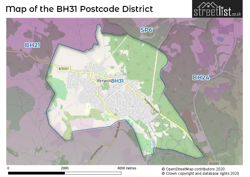
The BH31 Postcode shares a border with BH21 (WIMBORNE, Corfe Mullen, Three Legged Cross) and BH24 (RINGWOOD, St. Leonards, Ashley Heath).
In the BH31 postcode district in Dorset, the primary settlement is Verwood. Other significant settlements include the Ebblake Industrial Estate. The post town is Verwood, located in the county of Dorset, England.
For the district BH31, we have data on 3 postcode sectors. Here's a breakdown: The sector BH31 6, covers Verwood in Dorset. The sector BH31 7, covers Verwood in Dorset. The sector BH31 9 is non-geographic. It's often designated for PO Boxes, large organisations, or special services.


Map of the BH31 Postcode District
Explore the BH31 postcode district by using our free interactive map.
When it comes to local government, postal geography often disregards political borders. However, for a breakdown in the BH31 District: the district mostly encompasses the Dorset area with a total of 297 postcodes.
Weather Forecast for BH31
Press Button to Show Forecast for Edmondsham House
| Time Period | Icon | Description | Temperature | Rain Probability | Wind |
|---|---|---|---|---|---|
| 15:00 to 18:00 | Cloudy | 14.0°C (feels like 11.0°C) | 9.00% | NNW 13 mph | |
| 18:00 to 21:00 | Sunny day | 12.0°C (feels like 10.0°C) | 1.00% | N 11 mph | |
| 21:00 to 00:00 | Cloudy | 8.0°C (feels like 7.0°C) | 4.00% | NNE 7 mph |
Press Button to Show Forecast for Edmondsham House
| Time Period | Icon | Description | Temperature | Rain Probability | Wind |
|---|---|---|---|---|---|
| 00:00 to 03:00 | Partly cloudy (night) | 6.0°C (feels like 5.0°C) | 1.00% | NNE 7 mph | |
| 03:00 to 06:00 | Partly cloudy (night) | 4.0°C (feels like 2.0°C) | 0.00% | NNE 4 mph | |
| 06:00 to 09:00 | Cloudy | 5.0°C (feels like 3.0°C) | 3.00% | N 4 mph | |
| 09:00 to 12:00 | Cloudy | 8.0°C (feels like 6.0°C) | 3.00% | NNE 7 mph | |
| 12:00 to 15:00 | Overcast | 11.0°C (feels like 9.0°C) | 7.00% | N 9 mph | |
| 15:00 to 18:00 | Overcast | 12.0°C (feels like 10.0°C) | 7.00% | N 9 mph | |
| 18:00 to 21:00 | Overcast | 11.0°C (feels like 9.0°C) | 7.00% | NNE 7 mph | |
| 21:00 to 00:00 | Cloudy | 8.0°C (feels like 7.0°C) | 5.00% | NNE 4 mph |
Press Button to Show Forecast for Edmondsham House
| Time Period | Icon | Description | Temperature | Rain Probability | Wind |
|---|---|---|---|---|---|
| 00:00 to 03:00 | Partly cloudy (night) | 6.0°C (feels like 5.0°C) | 2.00% | N 4 mph | |
| 03:00 to 06:00 | Clear night | 5.0°C (feels like 4.0°C) | 1.00% | N 4 mph | |
| 06:00 to 09:00 | Partly cloudy (day) | 5.0°C (feels like 3.0°C) | 1.00% | NNE 7 mph | |
| 09:00 to 12:00 | Partly cloudy (day) | 8.0°C (feels like 6.0°C) | 1.00% | NNE 9 mph | |
| 12:00 to 15:00 | Overcast | 10.0°C (feels like 8.0°C) | 8.00% | NNE 11 mph | |
| 15:00 to 18:00 | Overcast | 11.0°C (feels like 8.0°C) | 9.00% | NNE 11 mph | |
| 18:00 to 21:00 | Cloudy | 10.0°C (feels like 8.0°C) | 6.00% | NNE 9 mph | |
| 21:00 to 00:00 | Partly cloudy (night) | 7.0°C (feels like 5.0°C) | 2.00% | NNE 7 mph |
Press Button to Show Forecast for Edmondsham House
| Time Period | Icon | Description | Temperature | Rain Probability | Wind |
|---|---|---|---|---|---|
| 00:00 to 03:00 | Clear night | 5.0°C (feels like 3.0°C) | 3.00% | NNE 7 mph | |
| 03:00 to 06:00 | Clear night | 4.0°C (feels like 1.0°C) | 2.00% | NNE 7 mph | |
| 06:00 to 09:00 | Cloudy | 4.0°C (feels like 1.0°C) | 6.00% | NNE 7 mph | |
| 09:00 to 12:00 | Cloudy | 8.0°C (feels like 6.0°C) | 6.00% | NNE 7 mph | |
| 12:00 to 15:00 | Overcast | 9.0°C (feels like 8.0°C) | 12.00% | NNE 7 mph | |
| 15:00 to 18:00 | Overcast | 9.0°C (feels like 8.0°C) | 17.00% | NNE 7 mph | |
| 18:00 to 21:00 | Light rain | 8.0°C (feels like 7.0°C) | 44.00% | N 7 mph | |
| 21:00 to 00:00 | Cloudy | 7.0°C (feels like 5.0°C) | 13.00% | N 7 mph |
Press Button to Show Forecast for Edmondsham House
| Time Period | Icon | Description | Temperature | Rain Probability | Wind |
|---|---|---|---|---|---|
| 00:00 to 03:00 | Cloudy | 6.0°C (feels like 4.0°C) | 10.00% | N 4 mph | |
| 03:00 to 06:00 | Cloudy | 5.0°C (feels like 3.0°C) | 6.00% | NNE 7 mph | |
| 06:00 to 09:00 | Partly cloudy (day) | 6.0°C (feels like 3.0°C) | 3.00% | N 7 mph | |
| 09:00 to 12:00 | Cloudy | 9.0°C (feels like 7.0°C) | 5.00% | NNE 9 mph | |
| 12:00 to 15:00 | Cloudy | 11.0°C (feels like 9.0°C) | 8.00% | NNE 9 mph | |
| 15:00 to 18:00 | Cloudy | 12.0°C (feels like 10.0°C) | 10.00% | N 9 mph | |
| 18:00 to 21:00 | Cloudy | 11.0°C (feels like 10.0°C) | 7.00% | NNE 7 mph | |
| 21:00 to 00:00 | Cloudy | 8.0°C (feels like 6.0°C) | 5.00% | N 7 mph |
Where is the BH31 Postcode District?
The data shows that the postcode district BH31 is located in Verwood. Verwood is a district town situated in close proximity to several nearby towns. To the South East, there is Ringwood which is approximately 4.18 miles away. In the North East, there is Fordingbridge which is around 4.54 miles away. To the South West, there is Wimborne, located at a distance of roughly 5.16 miles. Lastly, to the South, there is Ferndown, situated approximately 5.36 miles away. Additionally, the postcode district BH31 is located at a distance of 87.34 miles from London.
The district is within the post town of VERWOOD.
The sector has postcodes within the nation of England.
The BH31 Postcode District is in the region of within the .
| Postcode Sector | Delivery Office |
|---|---|
| BH31 6 | Verwood Delivery Office |
| BH31 7 | Verwood Delivery Office |
| B | H | 3 | 1 | - | X | X | X |
| B | H | 3 | 1 | Space | Numeric | Letter | Letter |
Current Monthly Rental Prices
| # Bedrooms | Min Price | Max Price | Avg Price |
|---|---|---|---|
| 4 | £2,500 | £2,500 | £2,500 |
Current House Prices
| # Bedrooms | Min Price | Max Price | Avg Price |
|---|---|---|---|
| 3 | £695,000 | £950,000 | £758,929 |
| 4 | £695,000 | £780,000 | £734,000 |
| 5 | £680,000 | £2,000,000 | £963,333 |
Estate Agents who Operate in the BH31 District
| Logo | Name | Brand Name | Address | Contact Number | Total Properties |
|---|---|---|---|---|---|
 | Verwood | Irving & Sons | 1 Edmondsham Road, Verwood, BH31 7PA | 020 3909 9786 | 39 |
 | Verwood | Goadsby | The Parade, 7 Ringwood Road, Verwood, BH31 7AA | 01202 037374 | 20 |
 | Verwood | Edwards | 11-13 Ringwood Road, Verwood, BH31 7AA | 020 3889 9093 | 17 |
 | Verwood | Castleman Estate Agents | 7 Station Road Verwood BH31 7PY | 01202 145451 | 7 |
 | Ringwood | Hearnes Estate Agents | 52-54 High Street, Ringwood, Hampshire, BH24 1AG | 01425 209264 | 7 |
| Type of Property | 2018 Average | 2018 Sales | 2017 Average | 2017 Sales | 2016 Average | 2016 Sales | 2015 Average | 2015 Sales |
|---|---|---|---|---|---|---|---|---|
| Detached | £411,698 | 163 | £394,358 | 193 | £380,759 | 199 | £349,161 | 206 |
| Semi-Detached | £292,617 | 42 | £284,919 | 32 | £259,034 | 34 | £252,188 | 33 |
| Terraced | £236,851 | 41 | £234,721 | 45 | £218,548 | 48 | £208,749 | 56 |
| Flats | £195,933 | 15 | £183,552 | 28 | £175,170 | 23 | £173,219 | 26 |
Hotels within the Postcode Area
We found 1 hotels and guest houses within the BH31 postcode area