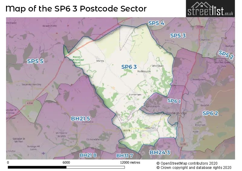
The SP6 3 postcode sector lies where the three counties of Dorset, Hampshire, and Wiltshire meet.
Did you know? According to the 2021 Census, the SP6 3 postcode sector is home to a bustling 4,704 residents!
Given that each sector allows for 400 unique postcode combinations. Letters C, I, K, M, O and V are not allowed in the last two letters of a postcode. With 193 postcodes already in use, this leaves 207 units available.
The largest settlement in the SP6 3 postal code is Alderholt followed by Damerham, and Martin.
The SP6 3 Postcode shares a border with BH24 3 (RINGWOOD, Crow, Hightown), BH31 7 (VERWOOD), BH21 5 (Cranborne, Witchampton, Wimborne St. Giles), SP5 3 (Downton, Alderbury, Whaddon), SP5 4 (Coombe Bissett, Bishopstone, Nunton), SP5 5 (Sixpenny Handley, Broad Chalke, Bowerchalke), SP6 1 (FORDINGBRIDGE, Sandleheath, Burgate) and SP6 2 (Godshill, Woodgreen, Breamore).
The sector is within the post town of FORDINGBRIDGE.
SP6 3 is a postcode sector within the SP6 postcode district which is within the BH Bournemouth postcode area.
The Royal Mail delivery office for the SP6 3 postal sector is the Fordingbridge Delivery Office.
The area of the SP6 3 postcode sector is 32.35 square miles which is 83.78 square kilometres or 20,703.63 square acres.

Map of the SP6 3 Postcode Sector
Explore the SP6 3 postcode sector by using our free interactive map.
| S | P | 6 | - | 3 | X | X |
| S | P | 6 | Space | 3 | Letter | Letter |
Official List of Streets
Alderholt (45 Streets)
FORDINGBRIDGE (3 Streets)
Martin (8 Streets)
Damerham (11 Streets)
Cripplestyle (1 Streets)
Lopshill (1 Streets)
Whitsbury (6 Streets)
Unofficial Streets or Alternative Spellings
Coombe Bissett
ROCKBOURNE ROADTinkers Cross
WHITSBURY ROADSandleheath
ROCKBOURNE ROADBroad Chalke
HOWGARE ROADCranborne
HARE LANE PYE LANEWeather Forecast for SP6 3
Press Button to Show Forecast for Whitsbury
| Time Period | Icon | Description | Temperature | Rain Probability | Wind |
|---|---|---|---|---|---|
| 03:00 to 06:00 | Cloudy | 6.0°C (feels like 4.0°C) | 5.00% | SW 7 mph | |
| 06:00 to 09:00 | Sunny day | 5.0°C (feels like 2.0°C) | 0.00% | WNW 7 mph | |
| 09:00 to 12:00 | Partly cloudy (day) | 10.0°C (feels like 8.0°C) | 8.00% | WNW 7 mph | |
| 12:00 to 15:00 | Overcast | 10.0°C (feels like 8.0°C) | 14.00% | W 9 mph | |
| 15:00 to 18:00 | Cloudy | 10.0°C (feels like 9.0°C) | 13.00% | WSW 9 mph | |
| 18:00 to 21:00 | Cloudy | 10.0°C (feels like 8.0°C) | 9.00% | WNW 7 mph | |
| 21:00 to 00:00 | Cloudy | 7.0°C (feels like 5.0°C) | 6.00% | N 7 mph |
Press Button to Show Forecast for Whitsbury
| Time Period | Icon | Description | Temperature | Rain Probability | Wind |
|---|---|---|---|---|---|
| 00:00 to 03:00 | Cloudy | 6.0°C (feels like 4.0°C) | 4.00% | NE 7 mph | |
| 03:00 to 06:00 | Cloudy | 6.0°C (feels like 3.0°C) | 6.00% | NE 7 mph | |
| 06:00 to 09:00 | Cloudy | 5.0°C (feels like 3.0°C) | 7.00% | ENE 7 mph | |
| 09:00 to 12:00 | Cloudy | 7.0°C (feels like 5.0°C) | 8.00% | ENE 9 mph | |
| 12:00 to 15:00 | Cloudy | 10.0°C (feels like 8.0°C) | 15.00% | E 9 mph | |
| 15:00 to 18:00 | Overcast | 10.0°C (feels like 8.0°C) | 19.00% | E 7 mph | |
| 18:00 to 21:00 | Overcast | 9.0°C (feels like 8.0°C) | 16.00% | ENE 7 mph | |
| 21:00 to 00:00 | Cloudy | 6.0°C (feels like 4.0°C) | 14.00% | ENE 7 mph |
Press Button to Show Forecast for Whitsbury
| Time Period | Icon | Description | Temperature | Rain Probability | Wind |
|---|---|---|---|---|---|
| 00:00 to 03:00 | Cloudy | 5.0°C (feels like 3.0°C) | 17.00% | ENE 7 mph | |
| 03:00 to 06:00 | Light rain | 5.0°C (feels like 3.0°C) | 53.00% | ENE 7 mph | |
| 06:00 to 09:00 | Light rain | 6.0°C (feels like 3.0°C) | 48.00% | NE 9 mph | |
| 09:00 to 12:00 | Cloudy | 8.0°C (feels like 5.0°C) | 16.00% | ENE 11 mph | |
| 12:00 to 15:00 | Overcast | 11.0°C (feels like 9.0°C) | 19.00% | E 11 mph | |
| 15:00 to 18:00 | Light rain | 11.0°C (feels like 9.0°C) | 52.00% | ENE 11 mph | |
| 18:00 to 21:00 | Light rain | 10.0°C (feels like 7.0°C) | 52.00% | ENE 11 mph | |
| 21:00 to 00:00 | Heavy rain | 9.0°C (feels like 6.0°C) | 73.00% | NE 11 mph |
Press Button to Show Forecast for Whitsbury
| Time Period | Icon | Description | Temperature | Rain Probability | Wind |
|---|---|---|---|---|---|
| 00:00 to 03:00 | Heavy rain | 8.0°C (feels like 5.0°C) | 75.00% | NE 11 mph | |
| 03:00 to 06:00 | Light rain | 7.0°C (feels like 5.0°C) | 56.00% | NE 11 mph | |
| 06:00 to 09:00 | Light rain | 8.0°C (feels like 6.0°C) | 51.00% | ENE 7 mph | |
| 09:00 to 12:00 | Light rain shower (day) | 10.0°C (feels like 7.0°C) | 39.00% | NE 9 mph | |
| 12:00 to 15:00 | Light rain | 11.0°C (feels like 8.0°C) | 49.00% | SW 11 mph | |
| 15:00 to 18:00 | Light rain shower (day) | 11.0°C (feels like 8.0°C) | 40.00% | W 11 mph | |
| 18:00 to 21:00 | Light rain shower (day) | 10.0°C (feels like 8.0°C) | 33.00% | SW 9 mph | |
| 21:00 to 00:00 | Partly cloudy (night) | 7.0°C (feels like 5.0°C) | 6.00% | SSE 7 mph |
Schools and Places of Education Within the SP6 3 Postcode Sector
St James' Church of England First School and Nursery, Alderholt
Academy converter
Park Lane, Fordingbridge, Hampshire, SP6 3AJ
Head: Headteacher Jo Hudson
Ofsted Rating: Good
Inspection: 2023-03-14 (408 days ago)
Website: Visit St James' Church of England First School and Nursery, Alderholt Website
Phone: 01425653063
Number of Pupils: 97
Western Downland Church of England Aided Primary School
Voluntary aided school
Rockbourne, Fordingbridge, Hampshire, SP6 3NA
Head: Mrs Alice Tubbs
Ofsted Rating: Good
Inspection: 2023-09-13 (225 days ago)
Website: Visit Western Downland Church of England Aided Primary School Website
Phone: 01725518233
Number of Pupils: 203
House Prices in the SP6 3 Postcode Sector
| Type of Property | 2018 Average | 2018 Sales | 2017 Average | 2017 Sales | 2016 Average | 2016 Sales | 2015 Average | 2015 Sales |
|---|---|---|---|---|---|---|---|---|
| Detached | £484,099 | 46 | £424,595 | 51 | £503,919 | 61 | £404,855 | 61 |
| Semi-Detached | £297,083 | 12 | £271,400 | 10 | £305,103 | 19 | £270,386 | 7 |
| Terraced | £232,000 | 10 | £259,250 | 6 | £227,636 | 11 | £220,100 | 10 |
| Flats | £265,000 | 3 | £187,000 | 4 | £0 | 0 | £130,000 | 1 |
Important Postcodes SP6 3 in the Postcode Sector
SP6 3AJ is the postcode for St. James C of E (Vc) First School, 17 Park Lane, and St James Church Of England First School, Park Lane
SP6 3HU is the postcode for Western Downland Primary School, Mill End
SP6 3NA is the postcode for Western Downland School, Rockbourne
| The SP6 3 Sector is within these Local Authorities |
|
|---|---|
| The SP6 3 Sector is within these Counties |
|
| The SP6 3 Sector is within these Water Company Areas |
|