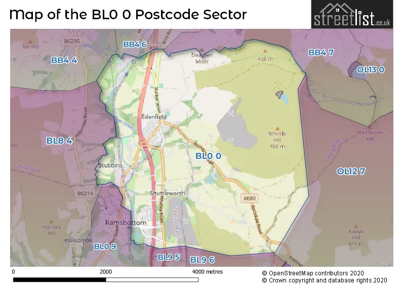
The BL0 0 postcode sector stands on the Greater Manchester and Lancashire border.
Did you know? According to the 2021 Census, the BL0 0 postcode sector is home to a bustling 5,586 residents!
Given that each sector allows for 400 unique postcode combinations. Letters C, I, K, M, O and V are not allowed in the last two letters of a postcode. With 226 postcodes already in use, this leaves 174 units available.
The BL0 0 postal code covers the settlement of Ramsbottom.
The BL0 0 Postcode shares a border with BB4 6 (ROSSENDALE, Haslingden, Rawtenstall), BB4 7 (ROSSENDALE, Rawtenstall, Waterfoot), OL12 7 (ROCHDALE), BL0 9 (Ramsbottom), BB4 4 (Haslingden, ROSSENDALE, Helmshore), BL8 4 (Greenmount, Hawkshaw, Tottington), BL9 5 (BURY, Summerseat, Walmersley) and BL9 6 (BURY, Nangreaves).
The sector is within the post town of BURY.
BL0 0 is a postcode sector within the BL0 postcode district which is within the BL Bolton postcode area.
The Royal Mail delivery office for the BL0 0 postal sector is the unknown.
The area of the BL0 0 postcode sector is 6.78 square miles which is 17.56 square kilometres or 4,338.41 square acres.
The BL0 0 postcode sector is crossed by the A56 Major A road.
The BL0 0 postcode sector is crossed by the M66 motorway.
Waterways within the BL0 0 postcode sector include the Irwell.

Map of the BL0 0 Postcode Sector
Explore the BL0 0 postcode sector by using our free interactive map.
| B | L | 0 | - | 0 | X | X |
| B | L | 0 | Space | 0 | Letter | Letter |
Official List of Streets
Ramsbottom (134 Streets)
Unofficial Streets or Alternative Spellings
Ramsbottom
BRIDGE STREET CHATTERTON OLD LANE DEARDEN CLOUGH MARKET PLACERawtenstall
BURY ROADROSSENDALE
FISH RAKE LANE IRWELL VALE ROADROCHDALE
EDENFIELD ROADBURY
CROSTON CLOSE ROADWeather Forecast for BL0 0
Press Button to Show Forecast for Whittle Hill
| Time Period | Icon | Description | Temperature | Rain Probability | Wind |
|---|---|---|---|---|---|
| 06:00 to 09:00 | Cloudy | 2.0°C (feels like -2.0°C) | 9.00% | WNW 13 mph | |
| 09:00 to 12:00 | Cloudy | 4.0°C (feels like 0.0°C) | 7.00% | NNW 13 mph | |
| 12:00 to 15:00 | Overcast | 4.0°C (feels like 1.0°C) | 13.00% | NE 9 mph | |
| 15:00 to 18:00 | Cloudy | 6.0°C (feels like 3.0°C) | 12.00% | N 9 mph | |
| 18:00 to 21:00 | Cloudy | 4.0°C (feels like 0.0°C) | 9.00% | NE 11 mph | |
| 21:00 to 00:00 | Cloudy | 2.0°C (feels like -2.0°C) | 5.00% | ENE 11 mph |
Press Button to Show Forecast for Whittle Hill
| Time Period | Icon | Description | Temperature | Rain Probability | Wind |
|---|---|---|---|---|---|
| 00:00 to 03:00 | Partly cloudy (night) | 0.0°C (feels like -5.0°C) | 4.00% | ENE 11 mph | |
| 03:00 to 06:00 | Clear night | -1.0°C (feels like -5.0°C) | 1.00% | ENE 9 mph | |
| 06:00 to 09:00 | Partly cloudy (day) | 0.0°C (feels like -3.0°C) | 2.00% | NE 9 mph | |
| 09:00 to 12:00 | Overcast | 3.0°C (feels like 1.0°C) | 9.00% | ENE 7 mph | |
| 12:00 to 15:00 | Overcast | 5.0°C (feels like 3.0°C) | 10.00% | E 7 mph | |
| 15:00 to 18:00 | Cloudy | 6.0°C (feels like 4.0°C) | 8.00% | E 7 mph | |
| 18:00 to 21:00 | Cloudy | 5.0°C (feels like 2.0°C) | 6.00% | ENE 9 mph | |
| 21:00 to 00:00 | Partly cloudy (night) | 2.0°C (feels like -2.0°C) | 3.00% | ENE 11 mph |
Press Button to Show Forecast for Whittle Hill
| Time Period | Icon | Description | Temperature | Rain Probability | Wind |
|---|---|---|---|---|---|
| 00:00 to 03:00 | Partly cloudy (night) | 1.0°C (feels like -4.0°C) | 3.00% | ENE 11 mph | |
| 03:00 to 06:00 | Partly cloudy (night) | 0.0°C (feels like -4.0°C) | 5.00% | ENE 9 mph | |
| 06:00 to 09:00 | Partly cloudy (day) | 1.0°C (feels like -3.0°C) | 7.00% | ENE 11 mph | |
| 09:00 to 12:00 | Cloudy | 4.0°C (feels like 1.0°C) | 10.00% | E 11 mph | |
| 12:00 to 15:00 | Overcast | 6.0°C (feels like 3.0°C) | 14.00% | E 11 mph | |
| 15:00 to 18:00 | Overcast | 6.0°C (feels like 3.0°C) | 19.00% | E 11 mph | |
| 18:00 to 21:00 | Cloudy | 6.0°C (feels like 2.0°C) | 16.00% | ENE 13 mph | |
| 21:00 to 00:00 | Cloudy | 3.0°C (feels like -1.0°C) | 15.00% | ENE 13 mph |
Press Button to Show Forecast for Whittle Hill
| Time Period | Icon | Description | Temperature | Rain Probability | Wind |
|---|---|---|---|---|---|
| 00:00 to 03:00 | Cloudy | 3.0°C (feels like -2.0°C) | 15.00% | NE 16 mph | |
| 03:00 to 06:00 | Overcast | 3.0°C (feels like -2.0°C) | 45.00% | NE 16 mph | |
| 06:00 to 09:00 | Light rain | 4.0°C (feels like -1.0°C) | 48.00% | NE 16 mph | |
| 09:00 to 12:00 | Light rain | 5.0°C (feels like 1.0°C) | 52.00% | NE 13 mph | |
| 12:00 to 15:00 | Light rain | 7.0°C (feels like 4.0°C) | 57.00% | NE 13 mph | |
| 15:00 to 18:00 | Heavy rain | 7.0°C (feels like 4.0°C) | 77.00% | N 11 mph | |
| 18:00 to 21:00 | Light rain | 6.0°C (feels like 3.0°C) | 47.00% | NNE 13 mph | |
| 21:00 to 00:00 | Partly cloudy (night) | 4.0°C (feels like 0.0°C) | 14.00% | N 11 mph |
Schools and Places of Education Within the BL0 0 Postcode Sector
Edenfield Church of England Primary School
Voluntary controlled school
Market Street, Bury, Lancashire, BL0 0HL
Head: Mrs Charlotte Garner
Ofsted Rating: Good
Inspection: 2023-10-19 (189 days ago)
Website: Visit Edenfield Church of England Primary School Website
Phone: 01706823608
Number of Pupils: 190
Peel Brow School
Academy converter
Fir Street, Bury, Lancashire, BL0 0BJ
Head: Miss Deborah Christiansen
Ofsted Rating: Requires improvement
Inspection: 2023-11-29 (148 days ago)
Website: Visit Peel Brow School Website
Phone: 01706823204
Number of Pupils: 153
Ramsbottom Stubbins Primary School
Community school
Bolton Road North, Bury, Lancashire, BL0 0NA
Head: Mrs Jill Cromey
Ofsted Rating: Good
Inspection: 2019-02-13 (1898 days ago)
Website: Visit Ramsbottom Stubbins Primary School Website
Phone: 01706822063
Number of Pupils: 201
Rossendale School
Other independent special school
Bamford Road, Bury, Lancashire, BL0 0RT
Head: Mr George Mills
Ofsted Rating: Good
Inspection: 2021-10-07 (931 days ago)
Website: Visit Rossendale School Website
Phone: 01706822779
Number of Pupils: 97
Woodlands
Other independent special school
Church Lane, Rossendale, Lancashire, BL0 0QL
Head: Ms Emma Fletcher
Ofsted Rating: Good
Inspection: 2021-09-30 (938 days ago)
Website: Visit Woodlands Website
Phone: 07901048480
Number of Pupils: 5
House Prices in the BL0 0 Postcode Sector
| Type of Property | 2018 Average | 2018 Sales | 2017 Average | 2017 Sales | 2016 Average | 2016 Sales | 2015 Average | 2015 Sales |
|---|---|---|---|---|---|---|---|---|
| Detached | £358,071 | 17 | £287,733 | 15 | £357,921 | 19 | £271,889 | 18 |
| Semi-Detached | £204,509 | 16 | £190,316 | 22 | £169,075 | 6 | £148,018 | 19 |
| Terraced | £159,177 | 73 | £148,003 | 75 | £145,088 | 68 | £139,807 | 69 |
| Flats | £144,790 | 5 | £124,667 | 6 | £112,533 | 9 | £95,800 | 5 |
Important Postcodes BL0 0 in the Postcode Sector
BL0 0BJ is the postcode for Peel Brow School, Fir Street, Ramsbottom, Peel Brow School, Fir Street, and NURSERY, Peel Brow School, Fir Street
BL0 0HL is the postcode for Edenfield C of E School, Market Street
BL0 0NA is the postcode for Stubbins Cp School, Bolton Road North, and Stubbins County Primary School, Bolton Road North, Edenfield
BL0 0PS is the postcode for Greater Manchester Fire & Rescue Service, Fire Station, Stubbins Lane
BL0 0PT is the postcode for Ramsbottom Swimming Pool, Stubbins Lane
| The BL0 0 Sector is within these Local Authorities |
|
|---|---|
| The BL0 0 Sector is within these Counties |
|
| The BL0 0 Sector is within these Water Company Areas |
|