The BL2 postcode district is a postal district located in the BL Bolton postcode area with a population of 47,216 residents according to the 2021 England and Wales Census.
The area of the BL2 postcode district is 8.14 square miles which is 21.08 square kilometres or 5,208.95 acres.
Currently, the BL2 district has about 1142 postcode units spread across 6 geographic postcode sectors.
Given that each sector allows for 400 unique postcode combinations, the district has a capacity of 2,400 postcodes. With 1142 postcodes already in use, this leaves 1258 units available.
The largest settlement in the BL2 postal code is BOLTON followed by Ainsworth, and Bradley Fold.
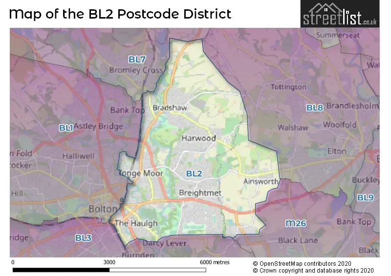
The BL2 Postcode shares a border with M26 (Radcliffe), BL3 (BOLTON, Little Lever), BL1 (BOLTON) and BL7 (Bromley Cross, Egerton, Turton).
In the BL2 postcode district, the primary settlement is Bolton, which is located in the county of Greater Manchester.
For the district BL2, we have data on 6 postcode sectors. Here's a breakdown: The sector BL2 1, covers Bolton in Greater Manchester. The sector BL2 2, covers Bolton in Greater Manchester. The sector BL2 3, covers Bolton in Greater Manchester. The sector BL2 4, covers Bolton in Greater Manchester. The sector BL2 5, covers Bolton and Ainsworth in Greater Manchester. The sector BL2 6, covers Bolton in Greater Manchester.

Map of the BL2 Postcode District
Explore the BL2 postcode district by using our free interactive map.
When it comes to local government, postal geography often disregards political borders. However, for a breakdown in the BL2 District: the district mostly encompasses the Bolton District (B) (1050 postcodes), and finally, the Bury District (B) area (99 postcodes).
Weather Forecast for BL2
Press Button to Show Forecast for Harwood
| Time Period | Icon | Description | Temperature | Rain Probability | Wind |
|---|---|---|---|---|---|
| 09:00 to 12:00 | Partly cloudy (day) | 9.0°C (feels like 7.0°C) | 4.00% | NW 9 mph | |
| 12:00 to 15:00 | Heavy rain shower (day) | 8.0°C (feels like 6.0°C) | 65.00% | NW 11 mph | |
| 15:00 to 18:00 | Heavy rain shower (day) | 9.0°C (feels like 6.0°C) | 81.00% | NW 11 mph | |
| 18:00 to 21:00 | Partly cloudy (day) | 8.0°C (feels like 6.0°C) | 4.00% | NW 9 mph | |
| 21:00 to 00:00 | Clear night | 6.0°C (feels like 3.0°C) | 3.00% | NW 11 mph |
Press Button to Show Forecast for Harwood
| Time Period | Icon | Description | Temperature | Rain Probability | Wind |
|---|---|---|---|---|---|
| 00:00 to 03:00 | Light rain shower (night) | 5.0°C (feels like 1.0°C) | 27.00% | NW 11 mph | |
| 03:00 to 06:00 | Clear night | 3.0°C (feels like 0.0°C) | 2.00% | NW 11 mph | |
| 06:00 to 09:00 | Sunny day | 3.0°C (feels like -1.0°C) | 1.00% | NW 11 mph | |
| 09:00 to 12:00 | Sunny day | 7.0°C (feels like 3.0°C) | 1.00% | NW 16 mph | |
| 12:00 to 15:00 | Cloudy | 9.0°C (feels like 5.0°C) | 6.00% | NW 16 mph | |
| 15:00 to 18:00 | Cloudy | 9.0°C (feels like 6.0°C) | 10.00% | NW 13 mph | |
| 18:00 to 21:00 | Light rain | 8.0°C (feels like 5.0°C) | 48.00% | NNW 9 mph | |
| 21:00 to 00:00 | Clear night | 5.0°C (feels like 4.0°C) | 3.00% | N 4 mph |
Press Button to Show Forecast for Harwood
| Time Period | Icon | Description | Temperature | Rain Probability | Wind |
|---|---|---|---|---|---|
| 00:00 to 03:00 | Clear night | 3.0°C (feels like 2.0°C) | 1.00% | NNE 4 mph | |
| 03:00 to 06:00 | Clear night | 2.0°C (feels like 1.0°C) | 2.00% | NNE 4 mph | |
| 06:00 to 09:00 | Partly cloudy (day) | 3.0°C (feels like 1.0°C) | 4.00% | NNE 2 mph | |
| 09:00 to 12:00 | Cloudy | 7.0°C (feels like 5.0°C) | 8.00% | SW 4 mph | |
| 12:00 to 15:00 | Overcast | 9.0°C (feels like 7.0°C) | 16.00% | W 9 mph | |
| 15:00 to 18:00 | Overcast | 9.0°C (feels like 7.0°C) | 23.00% | W 11 mph | |
| 18:00 to 21:00 | Light rain | 9.0°C (feels like 6.0°C) | 56.00% | W 11 mph | |
| 21:00 to 00:00 | Heavy rain | 8.0°C (feels like 5.0°C) | 72.00% | W 13 mph |
Press Button to Show Forecast for Harwood
| Time Period | Icon | Description | Temperature | Rain Probability | Wind |
|---|---|---|---|---|---|
| 00:00 to 03:00 | Light rain | 8.0°C (feels like 5.0°C) | 48.00% | WNW 13 mph | |
| 03:00 to 06:00 | Overcast | 8.0°C (feels like 4.0°C) | 16.00% | WNW 13 mph | |
| 06:00 to 09:00 | Cloudy | 7.0°C (feels like 4.0°C) | 10.00% | NW 13 mph | |
| 09:00 to 12:00 | Light rain shower (day) | 9.0°C (feels like 6.0°C) | 28.00% | NW 16 mph | |
| 12:00 to 15:00 | Overcast | 10.0°C (feels like 7.0°C) | 9.00% | NW 16 mph | |
| 15:00 to 18:00 | Cloudy | 11.0°C (feels like 8.0°C) | 7.00% | NW 16 mph | |
| 18:00 to 21:00 | Cloudy | 10.0°C (feels like 8.0°C) | 5.00% | NW 11 mph | |
| 21:00 to 00:00 | Partly cloudy (night) | 8.0°C (feels like 6.0°C) | 2.00% | NNW 9 mph |
Press Button to Show Forecast for Harwood
| Time Period | Icon | Description | Temperature | Rain Probability | Wind |
|---|---|---|---|---|---|
| 00:00 to 03:00 | Partly cloudy (night) | 6.0°C (feels like 4.0°C) | 2.00% | N 7 mph | |
| 03:00 to 06:00 | Clear night | 5.0°C (feels like 3.0°C) | 2.00% | NNE 4 mph | |
| 06:00 to 09:00 | Sunny day | 5.0°C (feels like 3.0°C) | 2.00% | NNE 4 mph | |
| 09:00 to 12:00 | Partly cloudy (day) | 8.0°C (feels like 7.0°C) | 2.00% | N 4 mph | |
| 12:00 to 15:00 | Partly cloudy (day) | 11.0°C (feels like 9.0°C) | 2.00% | NW 7 mph | |
| 15:00 to 18:00 | Cloudy | 12.0°C (feels like 11.0°C) | 4.00% | NW 7 mph | |
| 18:00 to 21:00 | Partly cloudy (day) | 11.0°C (feels like 9.0°C) | 1.00% | NW 9 mph | |
| 21:00 to 00:00 | Clear night | 8.0°C (feels like 7.0°C) | 1.00% | NW 4 mph |
Where is the BL2 Postcode District?
The data shows that the postcode district for BL2 is located in BOLTON, a town in the UK. BOLTON is situated near several other towns, including BURY to the East, DARWEN to the North West, SALFORD to the South East, LEIGH to the South West, ROSSENDALE to the North East, and WIGAN to the West. Additionally, BOLTON is approximately 172.75 miles away from the centre of London.
The district is within the post town of BOLTON.
The sector has postcodes within the nation of England.
The BL2 Postcode District is covers the following regions.
- Greater Manchester North West - Greater Manchester - North West (England)
- Greater Manchester North East - Greater Manchester - North West (England)
| Postcode Sector | Delivery Office |
|---|---|
| BL2 1 | Bolton North Delivery Office |
| BL2 2 | Bolton North Delivery Office |
| BL2 3 | Bolton North Delivery Office |
| BL2 4 | Bolton North Delivery Office |
| BL2 5 | Bolton North Delivery Office |
| BL2 6 | Bolton North Delivery Office |
| B | L | 2 | - | X | X | X |
| B | L | 2 | Space | Numeric | Letter | Letter |
Current Monthly Rental Prices
| # Bedrooms | Min Price | Max Price | Avg Price |
|---|---|---|---|
| 1 | £325 | £903 | £581 |
| 2 | £650 | £900 | £800 |
| 3 | £850 | £1,400 | £1,066 |
| 4 | £995 | £1,599 | £1,297 |
| 5 | £395 | £520 | £458 |
| 15 | £600 | £600 | £600 |
Current House Prices
| # Bedrooms | Min Price | Max Price | Avg Price |
|---|---|---|---|
| £475,000 | £500,000 | £487,500 | |
| 3 | £450,000 | £450,000 | £450,000 |
| 4 | £470,000 | £1,600,000 | £715,000 |
| 5 | £550,000 | £1,500,000 | £900,000 |
| 6 | £550,000 | £568,000 | £556,000 |
Estate Agents who Operate in the BL2 District
| Logo | Name | Brand Name | Address | Contact Number | Total Properties |
|---|---|---|---|---|---|
 | Harwood | Miller Metcalfe | 87a Lea Gate, Harwood, Bolton, BL2 4BQ | 01202 145374 | 52 |
 | Bolton | Cardwells Sales, Lettings, Management & Commercial | 11 Institute Street, Bolton, BL1 1PZ | 01204 326664 | 27 |
 | Bolton | Entwistle Green | 32 Deansgate Bolton BL1 1BG | 01204 326012 | 17 |
 | Bolton | Whittakers Estate Agents | 125 Lea Gate, Harwood, Bolton, BL2 4BQ | 01204 584742 | 15 |
 | Bolton | Miller Metcalfe | 2 - 10 Bradshawgate Bolton BL1 1DG | 01204 958258 | 10 |
| Type of Property | 2018 Average | 2018 Sales | 2017 Average | 2017 Sales | 2016 Average | 2016 Sales | 2015 Average | 2015 Sales |
|---|---|---|---|---|---|---|---|---|
| Detached | £268,105 | 136 | £244,060 | 109 | £230,728 | 122 | £218,021 | 92 |
| Semi-Detached | £152,758 | 256 | £141,330 | 240 | £136,480 | 276 | £130,160 | 246 |
| Terraced | £98,333 | 281 | £102,690 | 279 | £93,695 | 286 | £92,152 | 269 |
| Flats | £128,987 | 20 | £97,722 | 18 | £129,653 | 60 | £94,988 | 21 |
Hotels within the Postcode Area
We found 1 hotels and guest houses within the BL2 postcode area