The BL2 6 postcode sector is within the county of Greater Manchester.
Did you know? According to the 2021 Census, the BL2 6 postcode sector is home to a bustling 10,563 residents!
Given that each sector allows for 400 unique postcode combinations. Letters C, I, K, M, O and V are not allowed in the last two letters of a postcode. With 248 postcodes already in use, this leaves 152 units available.
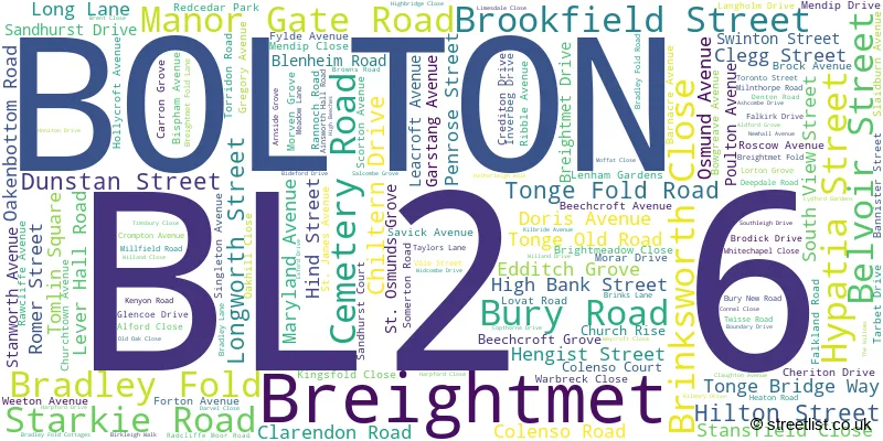
The largest settlement in the BL2 6 postal code is BOLTON followed by Bradley Fold, and Breightmet.
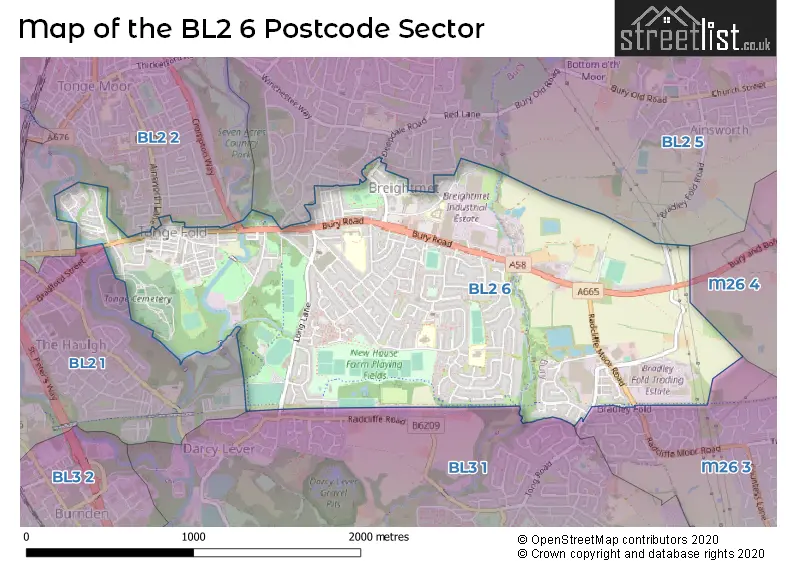
The BL2 6 Postcode shares a border with BL3 1 (Little Lever, BOLTON), M26 4 (Radcliffe), BL2 1 (BOLTON), BL2 2 (BOLTON), BL2 5 (BOLTON, Ainsworth) and M26 3 (Radcliffe).
The sector is within the post town of BOLTON.
BL2 6 is a postcode sector within the BL2 postcode district which is within the BL Bolton postcode area.
The Royal Mail delivery office for the BL2 6 postal sector is the Bolton North Delivery Office.
The area of the BL2 6 postcode sector is 1.57 square miles which is 4.07 square kilometres or 1,006.31 square acres.
Waterways within the BL2 6 postcode sector include the River Croal.

Map of the BL2 6 Postcode Sector
Explore the BL2 6 postcode sector by using our free interactive map.
| B | L | 2 | - | 6 | X | X |
| B | L | 2 | Space | 6 | Letter | Letter |
Official List of Streets
BOLTON (136 Streets)
Bradley Fold (12 Streets)
Unofficial Streets or Alternative Spellings
BOLTON
AINSWORTH LANE BOWSTONE RISE BRADFORD STREET BURY NEW ROAD CHRONNELL DRIVE CHURCH RISE CROMPTON WAY CROSSDALE ROAD EMPIRE ROAD FAIRMOUNT AVENUE SKELTON GROVE STEPHENS STREET BACK AINSWORTH LANE EAST BACK BROOKFIELD STREET BACK BURY ROAD BACK BURY ROAD EAST BACK BURY ROAD NORTH BACK BURY ROAD SOUTH BACK CEMETERY ROAD EAST BACK CLARENDON ROAD BACK CLEGG STREET BACK COLENSO ROAD BACK DUNSTAN STREET BACK EDDITCH GROVE BACK EDDITCH GROVE NORTH BACK EMPIRE ROAD BACK GREGORY AVENUE BACK HENGIST STREET BACK HIGH BANK STREET BACK HILTON STREET BACK HIND STREET BACK LEVER HALL ROAD BACK LONG LANE BACK OAKENBOTTOM ROAD NORTH BACK ROMER STREET BACK ROSCOW AVENUE BACK SALISBURY TERRACE BACK SOUTH VIEW STREET BACK TONGE OLD ROAD BASS STREET BOUNDARY STREET BRADLEY FOLD CYCLEWAY BRIAR STREET BURY AND BOLTON ROAD BURY OLD ROAD CHURCHILL STREET CRINAN WAY ERA STREET GIRTON STREET GORSES ROAD GREENGATE LANE HESWALL STREET KENNEDY STREET MAFEKING ROAD OLD WOOD LANE PRETORIA ROAD RED CEDAR PARK SACKVILLE STREET ST OSMUNDS DRIVE STANLEY MEWS STARMOUNT CLOSE THE HOLLIESAinsworth
AINSWORTH HALL ROAD BRADLEY FOLD ROADWeather Forecast for BL2 6
Press Button to Show Forecast for Bradley Fold
| Time Period | Icon | Description | Temperature | Rain Probability | Wind |
|---|---|---|---|---|---|
| 06:00 to 09:00 | Cloudy | 6.0°C (feels like 4.0°C) | 6.00% | WNW 7 mph | |
| 09:00 to 12:00 | Cloudy | 8.0°C (feels like 6.0°C) | 6.00% | NNW 9 mph | |
| 12:00 to 15:00 | Cloudy | 9.0°C (feels like 7.0°C) | 7.00% | N 7 mph | |
| 15:00 to 18:00 | Cloudy | 10.0°C (feels like 8.0°C) | 10.00% | N 7 mph | |
| 18:00 to 21:00 | Cloudy | 9.0°C (feels like 7.0°C) | 6.00% | NE 7 mph | |
| 21:00 to 00:00 | Cloudy | 7.0°C (feels like 5.0°C) | 5.00% | ENE 4 mph |
Press Button to Show Forecast for Bradley Fold
| Time Period | Icon | Description | Temperature | Rain Probability | Wind |
|---|---|---|---|---|---|
| 00:00 to 03:00 | Partly cloudy (night) | 5.0°C (feels like 3.0°C) | 3.00% | ENE 7 mph | |
| 03:00 to 06:00 | Clear night | 4.0°C (feels like 2.0°C) | 1.00% | ENE 4 mph | |
| 06:00 to 09:00 | Sunny day | 4.0°C (feels like 2.0°C) | 1.00% | NE 4 mph | |
| 09:00 to 12:00 | Partly cloudy (day) | 7.0°C (feels like 5.0°C) | 2.00% | E 4 mph | |
| 12:00 to 15:00 | Overcast | 9.0°C (feels like 8.0°C) | 8.00% | E 4 mph | |
| 15:00 to 18:00 | Cloudy | 10.0°C (feels like 9.0°C) | 6.00% | E 4 mph | |
| 18:00 to 21:00 | Cloudy | 9.0°C (feels like 8.0°C) | 6.00% | E 7 mph | |
| 21:00 to 00:00 | Cloudy | 7.0°C (feels like 5.0°C) | 7.00% | ENE 7 mph |
Press Button to Show Forecast for Bradley Fold
| Time Period | Icon | Description | Temperature | Rain Probability | Wind |
|---|---|---|---|---|---|
| 00:00 to 03:00 | Partly cloudy (night) | 5.0°C (feels like 3.0°C) | 5.00% | ENE 7 mph | |
| 03:00 to 06:00 | Partly cloudy (night) | 5.0°C (feels like 3.0°C) | 5.00% | ENE 4 mph | |
| 06:00 to 09:00 | Partly cloudy (day) | 5.0°C (feels like 3.0°C) | 5.00% | ENE 7 mph | |
| 09:00 to 12:00 | Cloudy | 8.0°C (feels like 5.0°C) | 8.00% | E 9 mph | |
| 12:00 to 15:00 | Cloudy | 10.0°C (feels like 8.0°C) | 12.00% | E 9 mph | |
| 15:00 to 18:00 | Cloudy | 10.0°C (feels like 8.0°C) | 17.00% | E 9 mph | |
| 18:00 to 21:00 | Cloudy | 10.0°C (feels like 7.0°C) | 16.00% | ENE 9 mph | |
| 21:00 to 00:00 | Cloudy | 8.0°C (feels like 5.0°C) | 17.00% | ENE 9 mph |
Press Button to Show Forecast for Bradley Fold
| Time Period | Icon | Description | Temperature | Rain Probability | Wind |
|---|---|---|---|---|---|
| 00:00 to 03:00 | Cloudy | 7.0°C (feels like 4.0°C) | 14.00% | ENE 9 mph | |
| 03:00 to 06:00 | Overcast | 7.0°C (feels like 4.0°C) | 23.00% | NE 9 mph | |
| 06:00 to 09:00 | Light rain | 7.0°C (feels like 5.0°C) | 47.00% | NE 9 mph | |
| 09:00 to 12:00 | Overcast | 9.0°C (feels like 7.0°C) | 21.00% | NE 9 mph | |
| 12:00 to 15:00 | Heavy rain | 10.0°C (feels like 8.0°C) | 76.00% | NE 9 mph | |
| 15:00 to 18:00 | Heavy rain | 11.0°C (feels like 9.0°C) | 73.00% | NE 9 mph | |
| 18:00 to 21:00 | Light rain shower (day) | 10.0°C (feels like 8.0°C) | 41.00% | N 9 mph | |
| 21:00 to 00:00 | Partly cloudy (night) | 9.0°C (feels like 7.0°C) | 14.00% | N 7 mph |
Schools and Places of Education Within the BL2 6 Postcode Sector
Blackshaw Primary School
Community school
Bideford Drive, Bolton, Lancashire, BL2 6TE
Head: Mrs Dorne Rutter
Ofsted Rating: Good
Inspection: 2019-09-12 (1687 days ago)
Website: Visit Blackshaw Primary School Website
Phone: 01204333505
Number of Pupils: 236
Leverhulme Community Primary School
Community school
Breightmet Drive, Bolton, Lancashire, BL2 6EE
Head: Mrs Sarah Curley
Ofsted Rating: Good
Inspection: 2021-12-01 (876 days ago)
Website: Visit Leverhulme Community Primary School Website
Phone: 01204333123
Number of Pupils: 436
SS Osmund and Andrew's R.C. Primary School
Voluntary aided school
Falkirk Drive, Bolton, Lancashire, BL2 6NW
Head: Mr James Graves
Ofsted Rating: Good
Inspection: 2023-01-12 (469 days ago)
Website: Visit SS Osmund and Andrew's R.C. Primary School Website
Phone: 01204333070
Number of Pupils: 423
House Prices in the BL2 6 Postcode Sector
| Type of Property | 2018 Average | 2018 Sales | 2017 Average | 2017 Sales | 2016 Average | 2016 Sales | 2015 Average | 2015 Sales |
|---|---|---|---|---|---|---|---|---|
| Detached | £207,007 | 14 | £210,032 | 12 | £204,675 | 20 | £155,767 | 15 |
| Semi-Detached | £131,667 | 60 | £129,140 | 56 | £128,789 | 63 | £120,605 | 62 |
| Terraced | £89,760 | 76 | £87,835 | 60 | £79,796 | 69 | £76,902 | 64 |
| Flats | £56,125 | 2 | £68,750 | 2 | £64,250 | 2 | £54,125 | 6 |
Important Postcodes BL2 6 in the Postcode Sector
BL2 6EB is the postcode for Leverhulme Park Community Club, Long Lane
BL2 6EE is the postcode for Leverhulme Community Primary School, Breightmet Drive
BL2 6EG is the postcode for Leverhulme Community Primary School, Poulton Avenue, and Leverhulme Primary School, Poulton Avenue
BL2 6HE is the postcode for Newhouse Farm Community Centre, Hollycroft Avenue
BL2 6NT is the postcode for Breightmet Health Centre, Breightmet Fold Lane
BL2 6NW is the postcode for S S Osmund & Andrews RC Primary School, Falkirk Drive, and SS Osmund & Andrews RC Primary School, Falkirk Drive
BL2 6PP is the postcode for Laburnum Lodge Home For The Elderly, Breightmet Fold Lane, and Laburnun Lodge EPH, Breightmet Fold Lane
BL2 6TE is the postcode for Blackshaw Primary School, Bideford Drive
| The BL2 6 Sector is within these Local Authorities |
|
|---|---|
| The BL2 6 Sector is within these Counties |
|
| The BL2 6 Sector is within these Water Company Areas |
|