The BN16 4 postcode sector is within the county of West Sussex.
Did you know? According to the 2021 Census, the BN16 4 postcode sector is home to a bustling 7,769 residents!
Given that each sector allows for 400 unique postcode combinations. Letters C, I, K, M, O and V are not allowed in the last two letters of a postcode. With 212 postcodes already in use, this leaves 188 units available.
The BN16 4 postal code covers the settlement of Angmering.
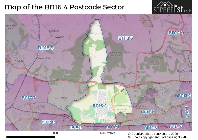
The BN16 4 Postcode shares a border with BN13 3 (WORTHING, Patching, Clapham), BN12 6 (Goring-by-Sea, Ferring), BN16 1 (East Preston), BN16 3 (Rustington, East Preston), BN17 7 (Wick, LITTLEHAMPTON, Lyminster) and BN18 9 (ARUNDEL, Amberley, Poling).
The sector is within the post town of LITTLEHAMPTON.
BN16 4 is a postcode sector within the BN16 postcode district which is within the BN Brighton postcode area.
The Royal Mail delivery office for the BN16 4 postal sector is the Littlehampton Delivery Office.
The area of the BN16 4 postcode sector is 4.39 square miles which is 11.36 square kilometres or 2,807.21 square acres.
The BN16 4 postcode sector is crossed by the A27 Major A road.
Waterways within the BN16 4 postcode sector include the Black Ditch.

Map of the BN16 4 Postcode Sector
Explore the BN16 4 postcode sector by using our free interactive map.
| B | N | 1 | 6 | - | 4 | X | X |
| B | N | 1 | 6 | Space | 4 | Letter | Letter |
Official List of Streets
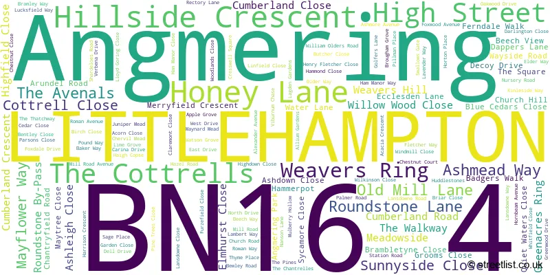
Angmering (147 Streets)
Unofficial Streets or Alternative Spellings
Ferring
HANGLETON LANE ANGMERING VILLAS BLUE CEDARS BLUE STAR ROUNDABOUT CHAPEL WALK CHESNUT COURT COW LN FERNDALE CLOSE ISABELLA PLACE MILL LANE ROUNDABOUT ROUNDSTONE BY-PASS ROAD ROUNDSTONE ROAD ROUNDABOUT ROUNDSTONE ROUNDABOUT SOUTH DRIVE THE BIRCHES THE CHANTERELLES WILLOWWOOD CLOSE WINDY RIDGE WOODFOOD VILLASEast Preston
DOWNS WAY HEATHFIELD AVENUERustington
MILL LANE NEW ROAD RUSTINGTON BYPASSPatching
SELDEN LANEWeather Forecast for BN16 4
Press Button to Show Forecast for Arundel Youth Hostel
| Time Period | Icon | Description | Temperature | Rain Probability | Wind |
|---|---|---|---|---|---|
| 21:00 to 00:00 | Cloudy | 8.0°C (feels like 6.0°C) | 5.00% | NNE 7 mph |
Press Button to Show Forecast for Arundel Youth Hostel
| Time Period | Icon | Description | Temperature | Rain Probability | Wind |
|---|---|---|---|---|---|
| 00:00 to 03:00 | Clear night | 5.0°C (feels like 3.0°C) | 0.00% | N 7 mph | |
| 03:00 to 06:00 | Clear night | 4.0°C (feels like 1.0°C) | 0.00% | N 9 mph | |
| 06:00 to 09:00 | Partly cloudy (day) | 4.0°C (feels like 1.0°C) | 1.00% | N 7 mph | |
| 09:00 to 12:00 | Cloudy | 8.0°C (feels like 5.0°C) | 3.00% | N 13 mph | |
| 12:00 to 15:00 | Cloudy | 11.0°C (feels like 8.0°C) | 4.00% | N 11 mph | |
| 15:00 to 18:00 | Cloudy | 12.0°C (feels like 9.0°C) | 4.00% | N 11 mph | |
| 18:00 to 21:00 | Cloudy | 10.0°C (feels like 8.0°C) | 4.00% | N 9 mph | |
| 21:00 to 00:00 | Cloudy | 7.0°C (feels like 5.0°C) | 4.00% | NNE 4 mph |
Press Button to Show Forecast for Arundel Youth Hostel
| Time Period | Icon | Description | Temperature | Rain Probability | Wind |
|---|---|---|---|---|---|
| 00:00 to 03:00 | Cloudy | 6.0°C (feels like 4.0°C) | 4.00% | NNE 4 mph | |
| 03:00 to 06:00 | Cloudy | 5.0°C (feels like 3.0°C) | 4.00% | N 7 mph | |
| 06:00 to 09:00 | Partly cloudy (day) | 5.0°C (feels like 2.0°C) | 2.00% | N 7 mph | |
| 09:00 to 12:00 | Overcast | 8.0°C (feels like 5.0°C) | 8.00% | NNE 11 mph | |
| 12:00 to 15:00 | Overcast | 10.0°C (feels like 7.0°C) | 9.00% | NNE 11 mph | |
| 15:00 to 18:00 | Overcast | 11.0°C (feels like 9.0°C) | 9.00% | NNE 11 mph | |
| 18:00 to 21:00 | Cloudy | 10.0°C (feels like 8.0°C) | 6.00% | NNE 11 mph | |
| 21:00 to 00:00 | Partly cloudy (night) | 7.0°C (feels like 5.0°C) | 3.00% | NNE 9 mph |
Press Button to Show Forecast for Arundel Youth Hostel
| Time Period | Icon | Description | Temperature | Rain Probability | Wind |
|---|---|---|---|---|---|
| 00:00 to 03:00 | Clear night | 5.0°C (feels like 3.0°C) | 2.00% | NNE 7 mph | |
| 03:00 to 06:00 | Clear night | 4.0°C (feels like 1.0°C) | 2.00% | N 7 mph | |
| 06:00 to 09:00 | Sunny day | 4.0°C (feels like 1.0°C) | 2.00% | N 7 mph | |
| 09:00 to 12:00 | Cloudy | 9.0°C (feels like 6.0°C) | 6.00% | NNE 9 mph | |
| 12:00 to 15:00 | Cloudy | 10.0°C (feels like 9.0°C) | 8.00% | NNE 9 mph | |
| 15:00 to 18:00 | Overcast | 10.0°C (feels like 9.0°C) | 15.00% | N 9 mph | |
| 18:00 to 21:00 | Overcast | 9.0°C (feels like 8.0°C) | 15.00% | N 7 mph | |
| 21:00 to 00:00 | Overcast | 7.0°C (feels like 5.0°C) | 13.00% | N 7 mph |
Press Button to Show Forecast for Arundel Youth Hostel
| Time Period | Icon | Description | Temperature | Rain Probability | Wind |
|---|---|---|---|---|---|
| 00:00 to 03:00 | Partly cloudy (night) | 6.0°C (feels like 4.0°C) | 7.00% | NNE 4 mph | |
| 03:00 to 06:00 | Partly cloudy (night) | 5.0°C (feels like 3.0°C) | 8.00% | N 4 mph | |
| 06:00 to 09:00 | Partly cloudy (day) | 5.0°C (feels like 3.0°C) | 5.00% | N 7 mph | |
| 09:00 to 12:00 | Overcast | 9.0°C (feels like 7.0°C) | 10.00% | NNE 9 mph | |
| 12:00 to 15:00 | Overcast | 11.0°C (feels like 9.0°C) | 10.00% | NNE 9 mph | |
| 15:00 to 18:00 | Cloudy | 12.0°C (feels like 10.0°C) | 10.00% | N 9 mph | |
| 18:00 to 21:00 | Cloudy | 11.0°C (feels like 9.0°C) | 8.00% | NNE 9 mph | |
| 21:00 to 00:00 | Cloudy | 8.0°C (feels like 6.0°C) | 6.00% | NNE 7 mph |
Schools and Places of Education Within the BN16 4 Postcode Sector
St Margaret's CofE Primary School
Voluntary aided school
Arundel Road, Littlehampton, West Sussex, BN16 4LP
Head: Mr Michael Jee
Ofsted Rating: Good
Inspection: 2022-09-29 (568 days ago)
Website: Visit St Margaret's CofE Primary School Website
Phone: 01903785416
Number of Pupils: 401
The Angmering School
Community school
Station Road, Littlehampton, West Sussex, BN16 4HH
Head: Mr Simon Liley
Ofsted Rating: Good
Inspection: 2022-10-12 (555 days ago)
Website: Visit The Angmering School Website
Phone: 01903772351
Number of Pupils: 1345
House Prices in the BN16 4 Postcode Sector
| Type of Property | 2018 Average | 2018 Sales | 2017 Average | 2017 Sales | 2016 Average | 2016 Sales | 2015 Average | 2015 Sales |
|---|---|---|---|---|---|---|---|---|
| Detached | £572,402 | 62 | £484,516 | 90 | £484,344 | 96 | £435,084 | 81 |
| Semi-Detached | £345,522 | 58 | £323,089 | 61 | £328,462 | 53 | £285,323 | 35 |
| Terraced | £308,694 | 52 | £287,236 | 53 | £264,310 | 33 | £237,428 | 40 |
| Flats | £219,083 | 12 | £217,778 | 9 | £108,860 | 11 | £219,200 | 5 |
Important Postcodes BN16 4 in the Postcode Sector
BN16 4HH is the postcode for A, D & S BLOCK, Angmering School, Station Road, Angmering School, Station Road, E BLOCK, Angmering School, Station Road, M BLOCK, Angmering School, Station Road, SPORTS PAVILLION, Angmering School, Station Road, BLOCK F, Angmering School, Station Road, C BLOCK, Angmering School, Station Road, N, B & L BLOCK, Angmering School, Station Road, and P BLOCK, Angmering School, Station Road
BN16 4HL is the postcode for Angmering Medical Centre, Station Road
BN16 4JR is the postcode for St. Wilfrids RC Primary School, Arundel Road
BN16 4LP is the postcode for St. Margarets C of E Primary School, Arundel Road, Angmering, and St. Margarets C of E Primary School, Arundel Road
| The BN16 4 Sector is within these Local Authorities |
|
|---|---|
| The BN16 4 Sector is within these Counties |
|
| The BN16 4 Sector is within these Water Company Areas |
|