The BN27 postcode district is a postal district located in the BN Brighton postcode area with a population of 32,317 residents according to the 2021 England and Wales Census.
The area of the BN27 postcode district is 43.62 square miles which is 112.98 square kilometres or 27,918.67 acres.
Currently, the BN27 district has about 1085 postcode units spread across 4 geographic postcode sectors.
Given that each sector allows for 400 unique postcode combinations, the district has a capacity of 1,600 postcodes. With 1085 postcodes already in use, this leaves 515 units available.
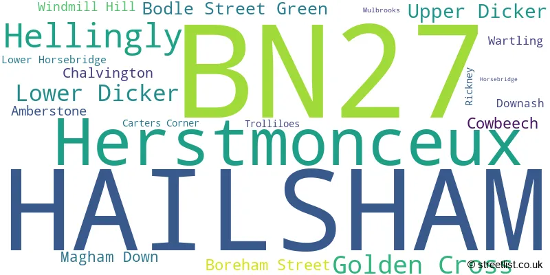
The largest settlement in the BN27 postal code is HAILSHAM followed by Hellingly, and Herstmonceux.
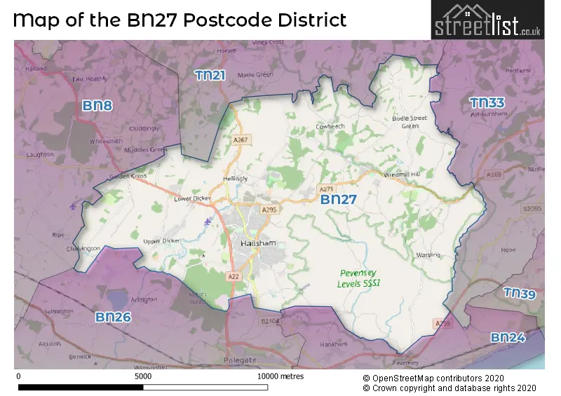
The BN27 Postcode shares a border with BN26 (POLEGATE, Alfriston, Berwick), BN8 (Ringmer, Newick, South Chailey), BN24 (Stone Cross, Pevensey Bay, Westham), TN21 (HEATHFIELD, Horam, Cross In Hand) and TN33 (BATTLE, Sedlescombe, Ninfield).
The primary settlement in the BN27 postcode district is Hailsham, located in the county of East Sussex in England. Other significant settlements in the district include Amberstone, Hellingly, Herstmonceux, Magham Down, Rickney, and Wartling. The most significant post town in the district is also Hailsham.
For the district BN27, we have data on 5 postcode sectors. Here's a breakdown: The sector BN27 1, covers Hailsham in East Sussex. The sector BN27 2, covers Hailsham in East Sussex. The sector BN27 3, covers Hailsham and Golden Cross in East Sussex. The sector BN27 4, covers Herstmonceux and Hellingly in East Sussex. The sector BN27 9 is non-geographic. It's often designated for PO Boxes, large organisations, or special services.

Map of the BN27 Postcode District
Explore the BN27 postcode district by using our free interactive map.
When it comes to local government, postal geography often disregards political borders. However, for a breakdown in the BN27 District: the district mostly encompasses the Wealden District area with a total of 1101 postcodes.
Weather Forecast for BN27
Press Button to Show Forecast for Herstmonceux West End
| Time Period | Icon | Description | Temperature | Rain Probability | Wind |
|---|---|---|---|---|---|
| 12:00 to 15:00 | Cloudy | 12.0°C (feels like 9.0°C) | 12.00% | WSW 9 mph | |
| 15:00 to 18:00 | Light rain | 11.0°C (feels like 8.0°C) | 48.00% | W 7 mph | |
| 18:00 to 21:00 | Light rain | 10.0°C (feels like 8.0°C) | 44.00% | W 4 mph | |
| 21:00 to 00:00 | Cloudy | 7.0°C (feels like 5.0°C) | 14.00% | NNE 2 mph |
Press Button to Show Forecast for Herstmonceux West End
| Time Period | Icon | Description | Temperature | Rain Probability | Wind |
|---|---|---|---|---|---|
| 00:00 to 03:00 | Cloudy | 6.0°C (feels like 4.0°C) | 8.00% | NE 4 mph | |
| 03:00 to 06:00 | Cloudy | 6.0°C (feels like 3.0°C) | 10.00% | NE 4 mph | |
| 06:00 to 09:00 | Cloudy | 6.0°C (feels like 3.0°C) | 10.00% | NE 4 mph | |
| 09:00 to 12:00 | Cloudy | 8.0°C (feels like 5.0°C) | 15.00% | E 7 mph | |
| 12:00 to 15:00 | Overcast | 10.0°C (feels like 7.0°C) | 15.00% | E 7 mph | |
| 15:00 to 18:00 | Cloudy | 10.0°C (feels like 8.0°C) | 11.00% | E 7 mph | |
| 18:00 to 21:00 | Overcast | 9.0°C (feels like 7.0°C) | 15.00% | E 7 mph | |
| 21:00 to 00:00 | Light rain | 7.0°C (feels like 5.0°C) | 46.00% | E 4 mph |
Press Button to Show Forecast for Herstmonceux West End
| Time Period | Icon | Description | Temperature | Rain Probability | Wind |
|---|---|---|---|---|---|
| 00:00 to 03:00 | Light rain | 7.0°C (feels like 5.0°C) | 48.00% | E 4 mph | |
| 03:00 to 06:00 | Cloudy | 7.0°C (feels like 5.0°C) | 18.00% | E 4 mph | |
| 06:00 to 09:00 | Cloudy | 8.0°C (feels like 6.0°C) | 19.00% | ESE 4 mph | |
| 09:00 to 12:00 | Cloudy | 11.0°C (feels like 8.0°C) | 15.00% | ESE 7 mph | |
| 12:00 to 15:00 | Cloudy | 12.0°C (feels like 10.0°C) | 18.00% | ESE 9 mph | |
| 15:00 to 18:00 | Light rain | 13.0°C (feels like 11.0°C) | 51.00% | E 7 mph | |
| 18:00 to 21:00 | Light rain | 11.0°C (feels like 9.0°C) | 48.00% | E 7 mph | |
| 21:00 to 00:00 | Light rain | 10.0°C (feels like 8.0°C) | 49.00% | E 7 mph |
Press Button to Show Forecast for Herstmonceux West End
| Time Period | Icon | Description | Temperature | Rain Probability | Wind |
|---|---|---|---|---|---|
| 00:00 to 03:00 | Light rain | 10.0°C (feels like 8.0°C) | 52.00% | ESE 7 mph | |
| 03:00 to 06:00 | Light rain | 9.0°C (feels like 7.0°C) | 51.00% | SE 7 mph | |
| 06:00 to 09:00 | Light rain shower (day) | 10.0°C (feels like 7.0°C) | 38.00% | SSE 7 mph | |
| 09:00 to 12:00 | Light rain shower (day) | 11.0°C (feels like 8.0°C) | 40.00% | SSE 9 mph | |
| 12:00 to 15:00 | Light rain shower (day) | 13.0°C (feels like 10.0°C) | 40.00% | SSW 11 mph | |
| 15:00 to 18:00 | Light rain shower (day) | 13.0°C (feels like 10.0°C) | 36.00% | SSW 9 mph | |
| 18:00 to 21:00 | Partly cloudy (day) | 12.0°C (feels like 10.0°C) | 12.00% | S 7 mph | |
| 21:00 to 00:00 | Partly cloudy (night) | 9.0°C (feels like 7.0°C) | 6.00% | SSW 4 mph |
Where is the BN27 Postcode District?
The postcode district BN27 is located in the town of Hailsham. Hailsham is surrounded by several nearby towns, including Polegate to the South West (3.77 miles away), Pevensey to the South East (4.54 miles away), Heathfield to the North (5.78 miles away), Eastbourne to the South (6.18 miles away), Bexhill-on-Sea to the East (7.43 miles away), and Uckfield to the North West (10.48 miles away). Additionally, Hailsham is approximately 47.14 miles away from the centre of London.
The district is within the post town of HAILSHAM.
The sector has postcodes within the nation of England.
The BN27 Postcode District is in the East Sussex CC region of Surrey, East and West Sussex within the South East (England).
| Postcode Sector | Delivery Office |
|---|---|
| BN27 1 | Hailsham Delivery Office |
| BN27 2 | Hailsham Delivery Office |
| BN27 3 | Hailsham Delivery Office |
| BN27 4 | Hailsham Delivery Office |
| B | N | 2 | 7 | - | X | X | X |
| B | N | 2 | 7 | Space | Numeric | Letter | Letter |
Tourist Attractions within the Postcode Area
We found 1 visitor attractions within the BN27 postcode area
| The Observatory Science Centre |
|---|
| Museums & Art Galleries |
| Science / Technology Centre |
| View The Observatory Science Centre on Google Maps |
Current Monthly Rental Prices
| # Bedrooms | Min Price | Max Price | Avg Price |
|---|---|---|---|
| £550 | £550 | £550 | |
| 1 | £850 | £950 | £906 |
| 2 | £1,100 | £1,200 | £1,133 |
| 3 | £1,475 | £2,250 | £1,925 |
| 4 | £1,600 | £2,950 | £2,217 |
| 5 | £2,350 | £3,750 | £2,700 |
| 6 | £2,200 | £3,000 | £2,733 |
Current House Prices
| # Bedrooms | Min Price | Max Price | Avg Price |
|---|---|---|---|
| £1,228,000 | £1,500,000 | £1,409,333 | |
| 4 | £350,000 | £1,500,000 | £1,159,990 |
| 5 | £1,150,000 | £1,500,000 | £1,257,143 |
| 6 | £1,300,000 | £4,500,000 | £2,237,500 |
| 7 | £1,250,000 | £1,250,000 | £1,250,000 |
| 8 | £1,900,000 | £2,850,000 | £2,375,000 |
| 10 | £1,500,000 | £1,500,000 | £1,500,000 |
Estate Agents who Operate in the BN27 District
| Logo | Name | Brand Name | Address | Contact Number | Total Properties |
|---|---|---|---|---|---|
 | Hailsham | Fox & Sons | 16 High Street, Hailsham, East Sussex BN27 1BJ | 01323 921615 | 46 |
 | Hailsham | Stevens & Carter | 47 High Street, Hailsham, East Sussex, BN27 1AN | 01323 921135 | 31 |
 | Hailsham | Crane & Co Estate Agents | 2 The Quintins, High Street, Hailsham, BN27 1DP | 01323 921857 | 29 |
 | Hailsham | Taylor Engley | 11 High Street, Hailsham, BN27 1AL | 01323 690089 | 22 |
 | Battle | Batcheller Monkhouse | 68 High Street Battle TN33 0AG | 01424 232425 | 18 |
- Bodle Street Green
- Boreham Street
- Chalvington
- Cogger's Cross
- Cowbeech
- Cowbeech Hill
- Flowers Green
- Golden Cross
- Golden Cross
- Grove Hill
- Hailsham
- Hankham
- Hellingly
- Herstmonceux
- Lower Dicker
- Lower Horsebridge
- Magham Down
- Marle Green
- Muddles Green
- Nash Street
- Pevensey
- Stunts Green
- Tile Hurst
- Trolliloes
- Upper Dicker
- Wartling
- Windmill Hill
| Type of Property | 2018 Average | 2018 Sales | 2017 Average | 2017 Sales | 2016 Average | 2016 Sales | 2015 Average | 2015 Sales |
|---|---|---|---|---|---|---|---|---|
| Detached | £404,063 | 199 | £379,364 | 228 | £363,387 | 201 | £341,551 | 196 |
| Semi-Detached | £263,657 | 228 | £264,969 | 208 | £250,201 | 225 | £235,888 | 187 |
| Terraced | £235,194 | 150 | £238,614 | 136 | £217,861 | 122 | £206,870 | 149 |
| Flats | £159,803 | 46 | £166,935 | 61 | £184,891 | 102 | £148,779 | 45 |