The BN27 4 postcode sector is within the county of East Sussex.
Did you know? According to the 2021 Census, the BN27 4 postcode sector is home to a bustling 6,522 residents!
Given that each sector allows for 400 unique postcode combinations. Letters C, I, K, M, O and V are not allowed in the last two letters of a postcode. With 244 postcodes already in use, this leaves 156 units available.
The largest settlement in the BN27 4 postal code is Hellingly followed by Herstmonceux, and Lower Dicker.
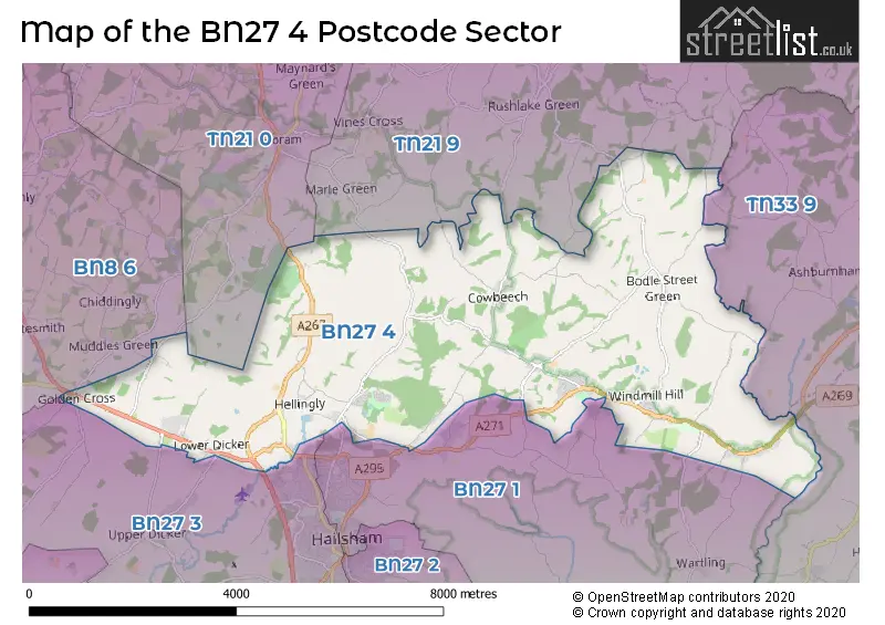
The BN27 4 Postcode shares a border with TN33 9 (Ninfield, Catsfield, Crowhurst), TN21 0 (Horam, HEATHFIELD, Cross In Hand), TN21 9 (Dallington, Punnetts Town, Rushlake Green), BN8 6 (East Hoathly, Laughton, Chiddingly), BN27 1 (HAILSHAM, Hellingly, Herstmonceux) and BN27 3 (HAILSHAM, Golden Cross, Upper Dicker).
The sector is within the post town of HAILSHAM.
BN27 4 is a postcode sector within the BN27 postcode district which is within the BN Brighton postcode area.
The Royal Mail delivery office for the BN27 4 postal sector is the Hailsham Delivery Office.
The area of the BN27 4 postcode sector is 18.19 square miles which is 47.12 square kilometres or 11,643.58 square acres.
Waterways within the BN27 4 postcode sector include the Cuckmere, Waller's Haven, Nunningham Stream.

Map of the BN27 4 Postcode Sector
Explore the BN27 4 postcode sector by using our free interactive map.
| B | N | 2 | 7 | - | 4 | X | X |
| B | N | 2 | 7 | Space | 4 | Letter | Letter |
Official List of Streets
Hellingly (41 Streets)
Herstmonceux (30 Streets)
Cowbeech (3 Streets)
Trolliloes (3 Streets)
Boreham Street (4 Streets)
Lower Dicker (4 Streets)
Carters Corner (1 Streets)
Lower Horsebridge (2 Streets)
HAILSHAM (1 Streets)
Windmill Hill (3 Streets)
Golden Cross (2 Streets)
Bodle Street Green (2 Streets)
Horsebridge (1 Streets)
Unofficial Streets or Alternative Spellings
Ashburnham
BRAYS HILL AMBERSTONE BLUEKILN LANE BOSHIP ROUNDABOUT BRAMLEY WALK CALDICOTTS LANE CHURCHES GREEN LANE CIDER HOLLOW COURT LODGE CLOSE COWBEECH ROAD FOUL MILE GINGERS GREEN ROAD HAWTHORNE LANE HENLEYS HILL LOWER HORSEBRIDGE MARLE GREEN MIDDLEWAY NO EVIDENCE OF PATH OAK HATCH STABLES PATH NOT VISIBLE PEBSHAM BRIDGE PIPPIN CLOSE PRINKLE LANE ROSEMOUNT RUSSETT WAY SANDHILL LANE SHRIEKS LANE SPRINGHAM BARN SPRINGHAM COTTAGE SPRINGHAM FARM SPRINGHAM OAST SPRINGHAM YARD SQUAB LANE SQUIRREL LANE STUNTS GREEN ROAD THE CUCKOO TRAIL THE MANOR THE STRAIT TOLL LANE TRUMPET LANE UPPER HORSEBRIDGE ROAD WEST TERRACE WHITE HORSE ROAD WINDMILL HILL ROADWartling
WARTLING ROAD WOOD LANEHerstmonceux
CHAPEL ROW PARK VIEWHellingly
GOLDFINCH LANE SISKIN ROADHAILSHAM
HAILSHAM BYPASSLower Dicker
CAMBERLOT ROAD COLDHARBOUR ROADGolden Cross
DEANLAND ROADWhitesmith
BURGH HILL ROADChalvington
CHALVINGTON ROADWeather Forecast for BN27 4
Press Button to Show Forecast for Herstmonceux West End
| Time Period | Icon | Description | Temperature | Rain Probability | Wind |
|---|---|---|---|---|---|
| 21:00 to 00:00 | Cloudy | 7.0°C (feels like 5.0°C) | 14.00% | NNE 2 mph |
Press Button to Show Forecast for Herstmonceux West End
| Time Period | Icon | Description | Temperature | Rain Probability | Wind |
|---|---|---|---|---|---|
| 00:00 to 03:00 | Cloudy | 6.0°C (feels like 4.0°C) | 8.00% | NE 4 mph | |
| 03:00 to 06:00 | Cloudy | 6.0°C (feels like 3.0°C) | 10.00% | NE 4 mph | |
| 06:00 to 09:00 | Cloudy | 6.0°C (feels like 3.0°C) | 10.00% | NE 4 mph | |
| 09:00 to 12:00 | Cloudy | 8.0°C (feels like 5.0°C) | 15.00% | E 7 mph | |
| 12:00 to 15:00 | Overcast | 10.0°C (feels like 7.0°C) | 15.00% | E 7 mph | |
| 15:00 to 18:00 | Cloudy | 10.0°C (feels like 8.0°C) | 11.00% | E 7 mph | |
| 18:00 to 21:00 | Overcast | 9.0°C (feels like 7.0°C) | 15.00% | E 7 mph | |
| 21:00 to 00:00 | Light rain | 7.0°C (feels like 5.0°C) | 46.00% | E 4 mph |
Press Button to Show Forecast for Herstmonceux West End
| Time Period | Icon | Description | Temperature | Rain Probability | Wind |
|---|---|---|---|---|---|
| 00:00 to 03:00 | Light rain | 7.0°C (feels like 5.0°C) | 48.00% | E 4 mph | |
| 03:00 to 06:00 | Cloudy | 7.0°C (feels like 5.0°C) | 18.00% | E 4 mph | |
| 06:00 to 09:00 | Cloudy | 8.0°C (feels like 6.0°C) | 19.00% | ESE 4 mph | |
| 09:00 to 12:00 | Cloudy | 11.0°C (feels like 8.0°C) | 15.00% | ESE 7 mph | |
| 12:00 to 15:00 | Cloudy | 12.0°C (feels like 10.0°C) | 18.00% | ESE 9 mph | |
| 15:00 to 18:00 | Light rain | 13.0°C (feels like 11.0°C) | 51.00% | E 7 mph | |
| 18:00 to 21:00 | Light rain | 11.0°C (feels like 9.0°C) | 48.00% | E 7 mph | |
| 21:00 to 00:00 | Light rain | 10.0°C (feels like 8.0°C) | 49.00% | E 7 mph |
Press Button to Show Forecast for Herstmonceux West End
| Time Period | Icon | Description | Temperature | Rain Probability | Wind |
|---|---|---|---|---|---|
| 00:00 to 03:00 | Light rain | 10.0°C (feels like 8.0°C) | 52.00% | ESE 7 mph | |
| 03:00 to 06:00 | Light rain | 9.0°C (feels like 7.0°C) | 51.00% | SE 7 mph | |
| 06:00 to 09:00 | Light rain shower (day) | 10.0°C (feels like 7.0°C) | 38.00% | SSE 7 mph | |
| 09:00 to 12:00 | Light rain shower (day) | 11.0°C (feels like 8.0°C) | 40.00% | SSE 9 mph | |
| 12:00 to 15:00 | Light rain shower (day) | 13.0°C (feels like 10.0°C) | 40.00% | SSW 11 mph | |
| 15:00 to 18:00 | Light rain shower (day) | 13.0°C (feels like 10.0°C) | 36.00% | SSW 9 mph | |
| 18:00 to 21:00 | Partly cloudy (day) | 12.0°C (feels like 10.0°C) | 12.00% | S 7 mph | |
| 21:00 to 00:00 | Partly cloudy (night) | 9.0°C (feels like 7.0°C) | 6.00% | SSW 4 mph |
Schools and Places of Education Within the BN27 4 Postcode Sector
Hellingly Community Primary School
Community school
North Street, Hailsham, East Sussex, BN27 4DS
Head: Michelle McKay
Ofsted Rating: Good
Inspection: 2021-06-17 (1043 days ago)
Website: Visit Hellingly Community Primary School Website
Phone: 01323844346
Number of Pupils: 198
Herstmonceux Church of England Primary School
Voluntary controlled school
Hailsham Road, Hailsham, East Sussex, BN27 4LG
Head: Headteacher Catherine Cottingham
Ofsted Rating: Good
Inspection: 2022-09-29 (574 days ago)
Website: Visit Herstmonceux Church of England Primary School Website
Phone: 01323833148
Number of Pupils: 207
House Prices in the BN27 4 Postcode Sector
| Type of Property | 2018 Average | 2018 Sales | 2017 Average | 2017 Sales | 2016 Average | 2016 Sales | 2015 Average | 2015 Sales |
|---|---|---|---|---|---|---|---|---|
| Detached | £499,316 | 38 | £500,425 | 42 | £465,400 | 34 | £399,725 | 42 |
| Semi-Detached | £275,439 | 33 | £303,163 | 33 | £286,894 | 33 | £249,945 | 28 |
| Terraced | £279,250 | 24 | £280,088 | 34 | £236,886 | 22 | £228,725 | 22 |
| Flats | £171,306 | 8 | £178,445 | 10 | £177,791 | 40 | £177,174 | 17 |
Important Postcodes BN27 4 in the Postcode Sector
BN27 4DS is the postcode for Hellingly Cp School, North Street
BN27 4EP is the postcode for Ashen Hill, The Drive, The Hellingly Centre, The Drive, Hellingly, School Health Department, The Firs, The Drive, Amberstone Hospital, Woodside Annexe, The Drive, Eastbourne & County Healthcare N H S Trust, Southview, The Drive, and The Hellingly Centre, The Drive
BN27 4ER is the postcode for Woodside, The Drive, Hellingly, Woodside, The Drive, East Sussex County Healthcare, Woodside Annexe, The Drive, and Woodside Annexe, The Drive
BN27 4EW is the postcode for Hailsham House, New Road
BN27 4FB is the postcode for HAILSHAM COMMUNITY PRIMARY SCHOOL, BULRUSH LANE, and Hailsham Primary Academy, Bulrush Lane
BN27 4HE is the postcode for New Road Nurseries, New Road
BN27 4HF is the postcode for Southview, Grove Hill
BN27 4HU is the postcode for Amberstone Hospital, Carters Corner
BN27 4JX is the postcode for Herstmonceux Integrative Health Centre, Hailsham Road
BN27 4LG is the postcode for Herstmonceux C of E School, Gardner Street, and Herstmonceux C of E School, Gardner Street, Herstmonceux
BN27 4LJ is the postcode for East Sussex Fire & Rescue Service, Fire Station, Hailsham Road
| The BN27 4 Sector is within these Local Authorities |
|
|---|---|
| The BN27 4 Sector is within these Counties |
|
| The BN27 4 Sector is within these Water Company Areas |
|