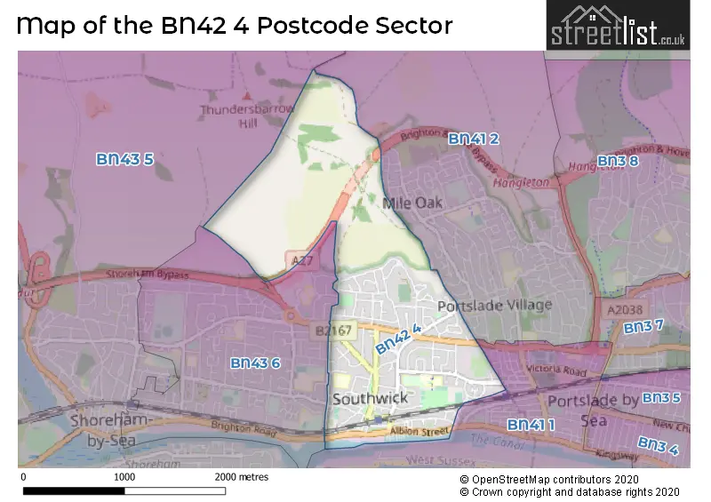
The BN42 4 postcode sector stands on the West Sussex and East Sussex border.
Did you know? According to the 2021 Census, the BN42 4 postcode sector is home to a bustling 10,759 residents!
Given that each sector allows for 400 unique postcode combinations. Letters C, I, K, M, O and V are not allowed in the last two letters of a postcode. With 218 postcodes already in use, this leaves 182 units available.
The BN42 4 postal code covers the settlement of Southwick.
The BN42 4 Postcode shares a border with BN41 1 (Portslade), BN41 2 (Portslade), BN43 5 (SHOREHAM-BY-SEA, Shoreham Airport) and BN43 6 (SHOREHAM-BY-SEA).
The sector is within the post town of BRIGHTON.
BN42 4 is a postcode sector within the BN42 postcode district which is within the BN Brighton postcode area.
The Royal Mail delivery office for the BN42 4 postal sector is the Portslade Delivery Office.
The area of the BN42 4 postcode sector is 1.81 square miles which is 4.68 square kilometres or 1,157.30 square acres.
The BN42 4 postcode sector is crossed by the A27 Major A road.

Map of the BN42 4 Postcode Sector
Explore the BN42 4 postcode sector by using our free interactive map.
| B | N | 4 | 2 | - | 4 | X | X |
| B | N | 4 | 2 | Space | 4 | Letter | Letter |
Official List of Streets
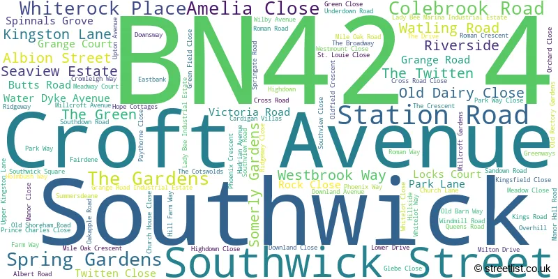
Southwick (98 Streets)
Unofficial Streets or Alternative Spellings
Weather Forecast for BN42 4
Press Button to Show Forecast for Southwick (West Sussex)
| Time Period | Icon | Description | Temperature | Rain Probability | Wind |
|---|---|---|---|---|---|
| 12:00 to 15:00 | Cloudy | 11.0°C (feels like 9.0°C) | 14.00% | WSW 13 mph | |
| 15:00 to 18:00 | Light rain | 11.0°C (feels like 8.0°C) | 45.00% | W 11 mph | |
| 18:00 to 21:00 | Cloudy | 10.0°C (feels like 8.0°C) | 14.00% | WSW 9 mph | |
| 21:00 to 00:00 | Cloudy | 8.0°C (feels like 7.0°C) | 8.00% | N 7 mph |
Press Button to Show Forecast for Southwick (West Sussex)
| Time Period | Icon | Description | Temperature | Rain Probability | Wind |
|---|---|---|---|---|---|
| 00:00 to 03:00 | Cloudy | 7.0°C (feels like 5.0°C) | 7.00% | ENE 7 mph | |
| 03:00 to 06:00 | Cloudy | 7.0°C (feels like 4.0°C) | 9.00% | ENE 7 mph | |
| 06:00 to 09:00 | Overcast | 6.0°C (feels like 4.0°C) | 12.00% | ENE 9 mph | |
| 09:00 to 12:00 | Overcast | 8.0°C (feels like 5.0°C) | 15.00% | E 11 mph | |
| 12:00 to 15:00 | Overcast | 9.0°C (feels like 7.0°C) | 17.00% | E 11 mph | |
| 15:00 to 18:00 | Overcast | 10.0°C (feels like 8.0°C) | 15.00% | ESE 9 mph | |
| 18:00 to 21:00 | Cloudy | 10.0°C (feels like 7.0°C) | 13.00% | E 9 mph | |
| 21:00 to 00:00 | Cloudy | 8.0°C (feels like 5.0°C) | 12.00% | E 11 mph |
Press Button to Show Forecast for Southwick (West Sussex)
| Time Period | Icon | Description | Temperature | Rain Probability | Wind |
|---|---|---|---|---|---|
| 00:00 to 03:00 | Light rain | 8.0°C (feels like 5.0°C) | 47.00% | E 11 mph | |
| 03:00 to 06:00 | Light rain | 8.0°C (feels like 5.0°C) | 50.00% | ENE 11 mph | |
| 06:00 to 09:00 | Cloudy | 8.0°C (feels like 6.0°C) | 18.00% | E 11 mph | |
| 09:00 to 12:00 | Cloudy | 11.0°C (feels like 8.0°C) | 15.00% | ESE 11 mph | |
| 12:00 to 15:00 | Light rain | 12.0°C (feels like 10.0°C) | 50.00% | ESE 11 mph | |
| 15:00 to 18:00 | Cloudy | 13.0°C (feels like 10.0°C) | 25.00% | E 11 mph | |
| 18:00 to 21:00 | Light rain | 12.0°C (feels like 9.0°C) | 49.00% | E 11 mph | |
| 21:00 to 00:00 | Light rain | 11.0°C (feels like 8.0°C) | 48.00% | ENE 11 mph |
Press Button to Show Forecast for Southwick (West Sussex)
| Time Period | Icon | Description | Temperature | Rain Probability | Wind |
|---|---|---|---|---|---|
| 00:00 to 03:00 | Cloudy | 10.0°C (feels like 8.0°C) | 21.00% | E 11 mph | |
| 03:00 to 06:00 | Light rain | 10.0°C (feels like 8.0°C) | 52.00% | E 11 mph | |
| 06:00 to 09:00 | Light rain shower (day) | 10.0°C (feels like 7.0°C) | 39.00% | SE 16 mph | |
| 09:00 to 12:00 | Light rain | 11.0°C (feels like 8.0°C) | 54.00% | SSE 16 mph | |
| 12:00 to 15:00 | Heavy rain shower (day) | 12.0°C (feels like 9.0°C) | 58.00% | S 16 mph | |
| 15:00 to 18:00 | Light rain shower (day) | 13.0°C (feels like 10.0°C) | 38.00% | SSW 16 mph | |
| 18:00 to 21:00 | Light rain shower (day) | 12.0°C (feels like 10.0°C) | 33.00% | SSW 13 mph | |
| 21:00 to 00:00 | Clear night | 11.0°C (feels like 8.0°C) | 7.00% | SW 11 mph |
Schools and Places of Education Within the BN42 4 Postcode Sector
Eastbrook Primary Academy
Academy sponsor led
Manor Hall Road, Brighton, West Sussex, BN42 4NF
Head: Mr Matthew Clark
Ofsted Rating: Outstanding
Inspection: 2015-07-02 (3220 days ago)
Website: Visit Eastbrook Primary Academy Website
Phone: 01273874050
Number of Pupils: 415
House Prices in the BN42 4 Postcode Sector
| Type of Property | 2018 Average | 2018 Sales | 2017 Average | 2017 Sales | 2016 Average | 2016 Sales | 2015 Average | 2015 Sales |
|---|---|---|---|---|---|---|---|---|
| Detached | £536,260 | 21 | £473,950 | 20 | £458,724 | 31 | £379,867 | 23 |
| Semi-Detached | £384,651 | 74 | £367,128 | 52 | £354,380 | 66 | £322,193 | 67 |
| Terraced | £346,328 | 33 | £319,929 | 38 | £317,974 | 34 | £299,093 | 43 |
| Flats | £221,356 | 36 | £215,068 | 22 | £206,000 | 30 | £193,846 | 24 |
Important Postcodes BN42 4 in the Postcode Sector
BN42 4FT is the postcode for Southwick Library & Health Centre, Southdown Road
BN42 4GB is the postcode for Glebe Cp School, Church Lane, Southwick, and Glebe Cp School, Church Lane
BN42 4NF is the postcode for Eastbrook Primary Academy, Manor Hall Road, NORTH JUNIOR SITE, Eastbrook Primary Academy (North Site), Manor Hall Road, Eastbrook Primary Academy (North Site), Manor Hall Road, and EASTBROOK PRIMARY ACADEMY, MANOR HALL ROAD, SOUTHWICK
BN42 4NT is the postcode for Impulse Leisure, Southwick Leisure Centre, Old Barn Way, Adur District Council, Southwick Leisure Centre, Old Barn Way, and Southwick Leisure Centre, Old Barn Way, Southwick
BN42 4RE is the postcode for Quayside Youth Club, Upper Kingston Lane
BN42 4TA is the postcode for The Manor Practice, Southwick Street
BN42 4TE is the postcode for North Buildings, Southwick Community Centre, 24 Southwick Street, and South Buildings, Southwick Community Centre, 24 Southwick Street
BN42 4WA is the postcode for 3 Downsway
| The BN42 4 Sector is within these Local Authorities |
|
|---|---|
| The BN42 4 Sector is within these Counties |
|
| The BN42 4 Sector is within these Water Company Areas |
|