The BN5 postcode district is a postal district located in the BN Brighton postcode area with a population of 8,038 residents according to the 2021 England and Wales Census.
The area of the BN5 postcode district is 17.93 square miles which is 46.45 square kilometres or 11,476.88 acres.
Currently, the BN5 district has about 296 postcode units spread across 1 geographic postcode sectors.
Given that each sector allows for 400 unique postcode combinations, the district has a capacity of 400 postcodes. With 296 postcodes already in use, this leaves 104 units available.
The largest settlement in the BN5 postal code is HENFIELD followed by Small Dole, and Woodmancote.
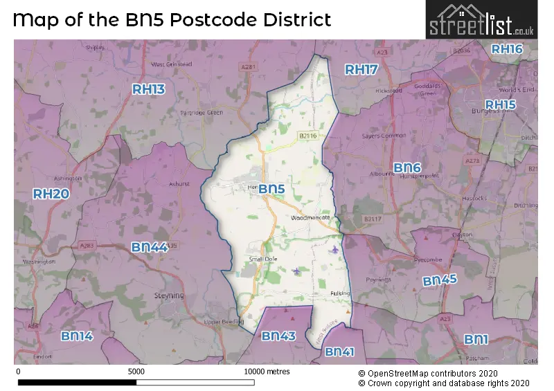
The BN5 Postcode shares a border with BN41 (Portslade), BN1 (BRIGHTON, Falmer), RH13 (HORSHAM, Southwater, Partridge Green), RH17 (Cuckfield, Balcombe, Ardingly), BN6 (HASSOCKS, Hurstpierpoint, Ditchling), BN43 (SHOREHAM-BY-SEA, Shoreham Airport) and BN44 (STEYNING, Upper Beeding, Bramber).
The primary settlement in the BN5 postcode district is Henfield, located in the county of West Sussex, England. Additionally, there are other significant settlements including Blackstone, Edburton, Fulking, Small Dole, Wineham, and Woodmancote, all located in West Sussex. The main post town for the BN5 postcode district is Henfield.
For the district BN5, we have data on 2 postcode sectors. Here's a breakdown: The sector BN5 0 is non-geographic. It's often designated for PO Boxes, large organisations, or special services. The sector BN5 9, covers Henfield in West Sussex.
BN5 Postcode Sectors

Map of the BN5 Postcode District
Explore the BN5 postcode district by using our free interactive map.
When it comes to local government, postal geography often disregards political borders. However, for a breakdown in the BN5 District: the district mostly encompasses the Horsham District (279 postcodes), and finally, the Mid Sussex District area (15 postcodes).
Weather Forecast for BN5
Press Button to Show Forecast for Henfield
| Time Period | Icon | Description | Temperature | Rain Probability | Wind |
|---|---|---|---|---|---|
| 12:00 to 15:00 | Cloudy | 10.0°C (feels like 7.0°C) | 4.00% | N 11 mph | |
| 15:00 to 18:00 | Cloudy | 11.0°C (feels like 9.0°C) | 3.00% | N 11 mph | |
| 18:00 to 21:00 | Cloudy | 10.0°C (feels like 8.0°C) | 4.00% | N 9 mph | |
| 21:00 to 00:00 | Cloudy | 7.0°C (feels like 5.0°C) | 3.00% | NNE 7 mph |
Press Button to Show Forecast for Henfield
| Time Period | Icon | Description | Temperature | Rain Probability | Wind |
|---|---|---|---|---|---|
| 00:00 to 03:00 | Partly cloudy (night) | 5.0°C (feels like 3.0°C) | 1.00% | N 7 mph | |
| 03:00 to 06:00 | Partly cloudy (night) | 4.0°C (feels like 1.0°C) | 1.00% | NNW 7 mph | |
| 06:00 to 09:00 | Partly cloudy (day) | 4.0°C (feels like 1.0°C) | 1.00% | NNW 9 mph | |
| 09:00 to 12:00 | Partly cloudy (day) | 8.0°C (feels like 5.0°C) | 0.00% | NNE 13 mph | |
| 12:00 to 15:00 | Cloudy | 11.0°C (feels like 8.0°C) | 4.00% | NNE 13 mph | |
| 15:00 to 18:00 | Cloudy | 11.0°C (feels like 8.0°C) | 4.00% | NE 13 mph | |
| 18:00 to 21:00 | Partly cloudy (day) | 9.0°C (feels like 7.0°C) | 1.00% | NE 9 mph | |
| 21:00 to 00:00 | Clear night | 7.0°C (feels like 4.0°C) | 1.00% | NNE 7 mph |
Press Button to Show Forecast for Henfield
| Time Period | Icon | Description | Temperature | Rain Probability | Wind |
|---|---|---|---|---|---|
| 00:00 to 03:00 | Clear night | 4.0°C (feels like 1.0°C) | 0.00% | NNE 7 mph | |
| 03:00 to 06:00 | Clear night | 3.0°C (feels like 0.0°C) | 0.00% | N 7 mph | |
| 06:00 to 09:00 | Sunny day | 4.0°C (feels like 1.0°C) | 1.00% | NNW 7 mph | |
| 09:00 to 12:00 | Cloudy | 8.0°C (feels like 6.0°C) | 4.00% | N 9 mph | |
| 12:00 to 15:00 | Cloudy | 10.0°C (feels like 8.0°C) | 6.00% | N 7 mph | |
| 15:00 to 18:00 | Overcast | 9.0°C (feels like 7.0°C) | 14.00% | NNW 7 mph | |
| 18:00 to 21:00 | Overcast | 8.0°C (feels like 6.0°C) | 18.00% | NNW 7 mph | |
| 21:00 to 00:00 | Cloudy | 6.0°C (feels like 5.0°C) | 12.00% | NNW 4 mph |
Press Button to Show Forecast for Henfield
| Time Period | Icon | Description | Temperature | Rain Probability | Wind |
|---|---|---|---|---|---|
| 00:00 to 03:00 | Cloudy | 6.0°C (feels like 4.0°C) | 11.00% | N 4 mph | |
| 03:00 to 06:00 | Cloudy | 6.0°C (feels like 4.0°C) | 11.00% | N 7 mph | |
| 06:00 to 09:00 | Cloudy | 6.0°C (feels like 3.0°C) | 9.00% | N 7 mph | |
| 09:00 to 12:00 | Overcast | 8.0°C (feels like 6.0°C) | 10.00% | N 9 mph | |
| 12:00 to 15:00 | Overcast | 10.0°C (feels like 7.0°C) | 11.00% | N 11 mph | |
| 15:00 to 18:00 | Overcast | 10.0°C (feels like 8.0°C) | 12.00% | N 11 mph | |
| 18:00 to 21:00 | Cloudy | 9.0°C (feels like 7.0°C) | 9.00% | N 9 mph | |
| 21:00 to 00:00 | Light rain shower (night) | 7.0°C (feels like 4.0°C) | 28.00% | NNE 9 mph |
Press Button to Show Forecast for Henfield
| Time Period | Icon | Description | Temperature | Rain Probability | Wind |
|---|---|---|---|---|---|
| 00:00 to 03:00 | Cloudy | 5.0°C (feels like 3.0°C) | 6.00% | N 7 mph | |
| 03:00 to 06:00 | Overcast | 4.0°C (feels like 1.0°C) | 8.00% | NNW 9 mph | |
| 06:00 to 09:00 | Overcast | 5.0°C (feels like 2.0°C) | 8.00% | NNW 9 mph | |
| 09:00 to 12:00 | Cloudy | 8.0°C (feels like 5.0°C) | 6.00% | NNW 11 mph | |
| 12:00 to 15:00 | Overcast | 10.0°C (feels like 7.0°C) | 9.00% | NNW 11 mph | |
| 15:00 to 18:00 | Overcast | 10.0°C (feels like 8.0°C) | 11.00% | NNW 11 mph | |
| 18:00 to 21:00 | Cloudy | 10.0°C (feels like 7.0°C) | 7.00% | NNW 9 mph | |
| 21:00 to 00:00 | Partly cloudy (night) | 7.0°C (feels like 5.0°C) | 3.00% | NNW 9 mph |
Where is the BN5 Postcode District?
The postcode district BN5 is located in the town of Henfield. It is near several other towns: Steyning is located to the South West, Hassocks is located to the East, Shoreham-By-Sea is located to the South, Burgess Hill is located to the North East, and Hove is located to the South East. Additionally, Henfield is approximately 40.9 miles away from the center of London.
The district covers the post towns of HENFIELD, STEYNING.
The sector has postcodes within the nation of England.
The BN5 Postcode District is in the West Sussex (North East) region of Surrey, East and West Sussex within the South East (England).
Postcode Sectors within the BN5 District
| Postcode Sector | Delivery Office |
|---|---|
| BN5 0 | Henfield Delivery Office |
| BN5 9 | Henfield Delivery Office |
| B | N | 5 | - | X | X | X |
| B | N | 5 | Space | Numeric | Letter | Letter |
Tourist Attractions within the Postcode Area
We found 2 visitor attractions within the BN5 postcode area
| Henfield Museum |
|---|
| Museums & Art Galleries |
| Museum and / or Art Gallery |
| View Henfield Museum on Google Maps |
| Sussex Prairies |
| Gardens |
| Garden |
| View Sussex Prairies on Google Maps |
Current Monthly Rental Prices
| # Bedrooms | Min Price | Max Price | Avg Price |
|---|---|---|---|
| £833 | £833 | £833 | |
| 1 | £750 | £750 | £750 |
| 2 | £1,200 | £1,200 | £1,200 |
| 4 | £2,250 | £2,750 | £2,417 |
Current House Prices
| # Bedrooms | Min Price | Max Price | Avg Price |
|---|---|---|---|
| 3 | £800,000 | £850,000 | £825,000 |
| 4 | £850,000 | £2,750,000 | £1,510,000 |
| 5 | £775,000 | £2,175,000 | £1,176,364 |
| 6 | £1,100,000 | £3,000,000 | £1,862,500 |
| 8 | £4,500,000 | £4,500,000 | £4,500,000 |
Estate Agents who Operate in the BN5 District
| Logo | Name | Brand Name | Address | Contact Number | Total Properties |
|---|---|---|---|---|---|
 | Henfield | Stevens | 1 Bishop Croft, High Street, Henfield, BN5 9DA | 01273 092659 | 18 |
 | Hove | Foster & Co | Ground Floor, 10 The Drive, Hove, BN3 3JA | 01273 109822 | 10 |
 | Henfield | H J Burt | Euston House High Street, Henfield, BN5 9DD | 01273 109759 | 9 |
 | Hove | Hamlyn Smith | 1 Hova Villas, Hove, BN3 3DH | 01270 433440 | 8 |
 | Steyning | Mansell McTaggart | 118 High Street, Steyning, BN44 3RD | 01903 254742 | 7 |
| Type of Property | 2018 Average | 2018 Sales | 2017 Average | 2017 Sales | 2016 Average | 2016 Sales | 2015 Average | 2015 Sales |
|---|---|---|---|---|---|---|---|---|
| Detached | £603,684 | 87 | £573,687 | 87 | £707,828 | 35 | £576,512 | 57 |
| Semi-Detached | £410,960 | 53 | £394,773 | 60 | £352,055 | 41 | £359,568 | 45 |
| Terraced | £290,124 | 16 | £324,231 | 26 | £335,412 | 17 | £321,868 | 19 |
| Flats | £227,538 | 12 | £229,175 | 14 | £191,444 | 9 | £180,267 | 15 |
Hotels within the Postcode Area
We found 7 hotels and guest houses within the BN5 postcode area