The BR5 2 postcode sector is within the county of Greater London.
Did you know? According to the 2021 Census, the BR5 2 postcode sector is home to a bustling 14,221 residents!
Given that each sector allows for 400 unique postcode combinations. Letters C, I, K, M, O and V are not allowed in the last two letters of a postcode. With 258 postcodes already in use, this leaves 142 units available.
The largest settlement in the BR5 2 postal code is ORPINGTON followed by CHISLEHURST , and ST PAULS CRAY .
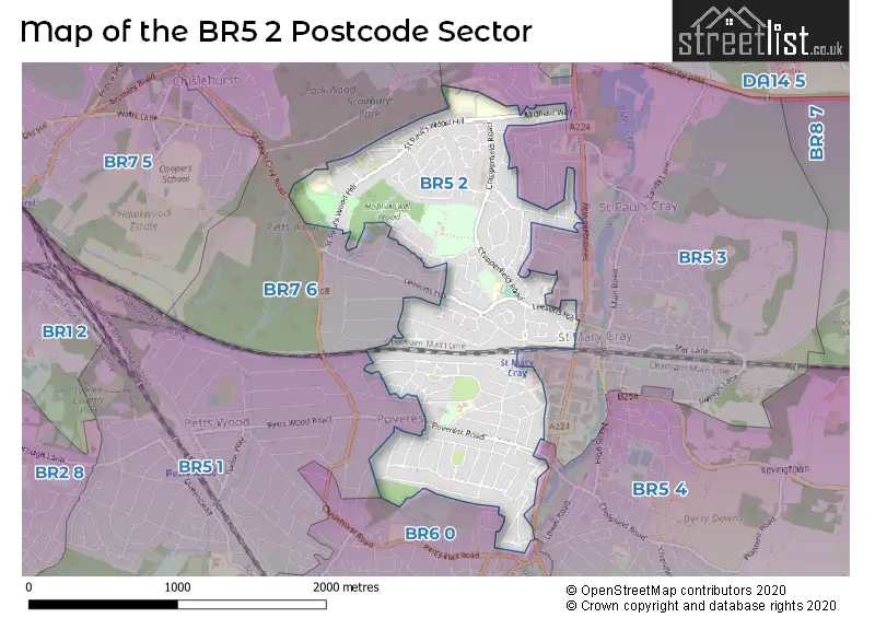
The BR5 2 Postcode shares a border with BR5 1 (PETTS WOOD , ORPINGTON ), BR6 0 (ORPINGTON , PETTS WOOD ), BR7 6 (CHISLEHURST , ORPINGTON ), BR5 3 (ORPINGTON , ST PAULS CRAY , ST MARY CRAY ) and BR5 4 (ORPINGTON , ST MARY CRAY ).
The sector is within the post town of ORPINGTON.
BR5 2 is a postcode sector within the BR5 postcode district which is within the BR Bromley postcode area.
The Royal Mail delivery office for the BR5 2 postal sector is the Orpington Delivery Office.
The area of the BR5 2 postcode sector is 1.14 square miles which is 2.96 square kilometres or 730.36 square acres.

Map of the BR5 2 Postcode Sector
Explore the BR5 2 postcode sector by using our free interactive map.
| B | R | 5 | - | 2 | X | X |
| B | R | 5 | Space | 2 | Letter | Letter |
Official List of Streets
ORPINGTON (112 Streets)
St. Pauls Cray (7 Streets)
St. Mary Cray (1 Streets)
Unofficial Streets or Alternative Spellings
ORPINGTON,
SEVENOAKS WAYORPINGTON
BROOM AVENUE CARLTON PARADE CROXLEY GREEN DAWSON AVENUE FARADAY WAY FARRINGTON AVENUE GLENDOWER CRESCENT GOODMEAD ROAD GROVELANDS ROAD HORSELL ROAD KELSEY ROAD MURRAY ROAD ROBIN WAY SAXVILLE ROAD WHIPPENDELL WAY LEE GREEN SEVEN STILES COURT ST PAULS CRAY ROAD SWARD ROAD THE METRO CENTRE WIMBORNE ROADSt. Pauls Cray
THE AVENUESt. Mary Cray
CRAY AVENUE FURZEHILL SQUARECHISLEHURST,
CLARENDON WAY KEVINGTON DRIVE LEESONS HILL WIMBORNE AVENUEPetts Wood
POVEREST ROAD SEFTON CLOSE SEFTON ROAD SHERBORNE ROAD SUTHERLAND AVENUECHISLEHURST
BERENS WAYWeather Forecast for BR5 2
Press Button to Show Forecast for Bromley Ski Centre
| Time Period | Icon | Description | Temperature | Rain Probability | Wind |
|---|---|---|---|---|---|
| 15:00 to 18:00 | Cloudy | 11.0°C (feels like 9.0°C) | 14.00% | WNW 9 mph | |
| 18:00 to 21:00 | Cloudy | 9.0°C (feels like 8.0°C) | 15.00% | N 7 mph | |
| 21:00 to 00:00 | Cloudy | 7.0°C (feels like 6.0°C) | 9.00% | ENE 4 mph |
Press Button to Show Forecast for Bromley Ski Centre
| Time Period | Icon | Description | Temperature | Rain Probability | Wind |
|---|---|---|---|---|---|
| 00:00 to 03:00 | Cloudy | 6.0°C (feels like 5.0°C) | 7.00% | NE 4 mph | |
| 03:00 to 06:00 | Cloudy | 5.0°C (feels like 3.0°C) | 4.00% | NE 4 mph | |
| 06:00 to 09:00 | Cloudy | 5.0°C (feels like 3.0°C) | 5.00% | NE 4 mph | |
| 09:00 to 12:00 | Cloudy | 7.0°C (feels like 5.0°C) | 5.00% | ENE 7 mph | |
| 12:00 to 15:00 | Overcast | 9.0°C (feels like 8.0°C) | 11.00% | E 7 mph | |
| 15:00 to 18:00 | Overcast | 10.0°C (feels like 8.0°C) | 15.00% | E 7 mph | |
| 18:00 to 21:00 | Cloudy | 9.0°C (feels like 7.0°C) | 13.00% | E 9 mph | |
| 21:00 to 00:00 | Cloudy | 8.0°C (feels like 6.0°C) | 14.00% | E 7 mph |
Press Button to Show Forecast for Bromley Ski Centre
| Time Period | Icon | Description | Temperature | Rain Probability | Wind |
|---|---|---|---|---|---|
| 00:00 to 03:00 | Light rain | 7.0°C (feels like 5.0°C) | 46.00% | E 7 mph | |
| 03:00 to 06:00 | Light rain | 7.0°C (feels like 4.0°C) | 48.00% | ENE 7 mph | |
| 06:00 to 09:00 | Light rain | 7.0°C (feels like 5.0°C) | 48.00% | ENE 7 mph | |
| 09:00 to 12:00 | Cloudy | 9.0°C (feels like 7.0°C) | 17.00% | E 9 mph | |
| 12:00 to 15:00 | Cloudy | 12.0°C (feels like 10.0°C) | 17.00% | E 9 mph | |
| 15:00 to 18:00 | Light rain | 12.0°C (feels like 10.0°C) | 50.00% | E 9 mph | |
| 18:00 to 21:00 | Light rain | 11.0°C (feels like 9.0°C) | 51.00% | E 9 mph | |
| 21:00 to 00:00 | Light rain | 10.0°C (feels like 8.0°C) | 49.00% | ENE 9 mph |
Press Button to Show Forecast for Bromley Ski Centre
| Time Period | Icon | Description | Temperature | Rain Probability | Wind |
|---|---|---|---|---|---|
| 00:00 to 03:00 | Light rain | 10.0°C (feels like 8.0°C) | 54.00% | ENE 7 mph | |
| 03:00 to 06:00 | Cloudy | 9.0°C (feels like 8.0°C) | 26.00% | E 7 mph | |
| 06:00 to 09:00 | Light rain | 9.0°C (feels like 8.0°C) | 53.00% | E 7 mph | |
| 09:00 to 12:00 | Light rain shower (day) | 11.0°C (feels like 9.0°C) | 41.00% | SE 9 mph | |
| 12:00 to 15:00 | Heavy rain shower (day) | 13.0°C (feels like 10.0°C) | 59.00% | S 11 mph | |
| 15:00 to 18:00 | Heavy rain shower (day) | 14.0°C (feels like 11.0°C) | 55.00% | S 11 mph | |
| 18:00 to 21:00 | Light rain shower (day) | 13.0°C (feels like 11.0°C) | 35.00% | S 9 mph | |
| 21:00 to 00:00 | Clear night | 11.0°C (feels like 9.0°C) | 9.00% | S 7 mph |
Schools and Places of Education Within the BR5 2 Postcode Sector
Leesons Primary School
Academy converter
Leesons Hill, Orpington, Kent, BR5 2GA
Head: Mr Phillip Collins
Ofsted Rating: Requires improvement
Inspection: 2022-11-30 (512 days ago)
Website: Visit Leesons Primary School Website
Phone: 01689602786
Number of Pupils: 385
Poverest Primary School
Foundation school
Tillingbourne Green, Orpington, Kent, BR5 2JD
Head: Mr Paul Haylock
Ofsted Rating: Good
Inspection: 2018-09-18 (2046 days ago)
Website: Visit Poverest Primary School Website
Phone: 01689816060
Number of Pupils: 429
St Peter and St Paul Catholic Primary School
Academy converter
St Paul's Wood Hill, Orpington, Kent, BR5 2SR
Head: Miss Kirsty Everson
Ofsted Rating: Good
Inspection: 2022-11-23 (519 days ago)
Website: Visit St Peter and St Paul Catholic Primary School Website
Phone: 01689828208
Number of Pupils: 231
House Prices in the BR5 2 Postcode Sector
| Type of Property | 2018 Average | 2018 Sales | 2017 Average | 2017 Sales | 2016 Average | 2016 Sales | 2015 Average | 2015 Sales |
|---|---|---|---|---|---|---|---|---|
| Detached | £460,722 | 18 | £515,000 | 12 | £474,900 | 20 | £398,612 | 13 |
| Semi-Detached | £382,393 | 89 | £359,231 | 67 | £352,881 | 91 | £323,550 | 104 |
| Terraced | £315,176 | 54 | £320,789 | 37 | £322,191 | 65 | £267,114 | 61 |
| Flats | £216,467 | 28 | £224,858 | 39 | £209,161 | 34 | £175,217 | 31 |
Important Postcodes BR5 2 in the Postcode Sector
BR5 2GA is the postcode for Leesons Primary School, Leesons Hill
BR5 2JD is the postcode for Poverest Primary School, Church Hill Wood, and DINING HALL, Poverest Primary School, Church Hill Wood
BR5 2JP is the postcode for Doctors Surgery, 41 Broomwood Road
BR5 2RW is the postcode for St. Pauls Cray Library, Mickleham Road
BR5 2SR is the postcode for St. Peter and St. Paul Catholic Primary School, St. Paul's Wood Hill
| The BR5 2 Sector is within these Local Authorities |
|
|---|---|
| The BR5 2 Sector is within these Counties |
|
| The BR5 2 Sector is within these Water Company Areas |
|