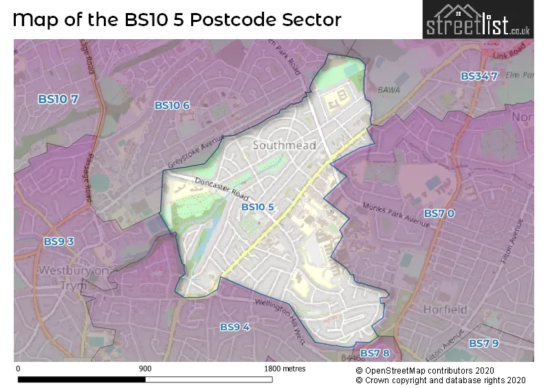
The BS10 5 postcode sector stands on the Bristol and Gloucestershire border.
Did you know? According to the 2021 Census, the BS10 5 postcode sector is home to a bustling 10,057 residents!
Given that each sector allows for 400 unique postcode combinations. Letters C, I, K, M, O and V are not allowed in the last two letters of a postcode. With 204 postcodes already in use, this leaves 196 units available.
The largest settlement in the BS10 5 postal code is BRISTOL followed by Westbury-on-Trym, and Southmead.
The BS10 5 Postcode shares a border with BS7 0 (BRISTOL, Horfield), BS34 7 (Filton, BRISTOL), BS7 8 (BRISTOL, Bishopston, Horfield), BS9 3 (BRISTOL, Westbury-on-Trym), BS9 4 (BRISTOL, Westbury-on-Trym, Henleaze) and BS10 6 (BRISTOL, Brentry, Westbury-on-Trym).
The sector is within the post town of BRISTOL.
BS10 5 is a postcode sector within the BS10 postcode district which is within the BS Bristol postcode area.
The Royal Mail delivery office for the BS10 5 postal sector is the Westbury On Trym Delivery Office.
The area of the BS10 5 postcode sector is 0.69 square miles which is 1.80 square kilometres or 444.04 square acres.
Waterways within the BS10 5 postcode sector include the Trym.

Map of the BS10 5 Postcode Sector
Explore the BS10 5 postcode sector by using our free interactive map.
| B | S | 1 | 0 | - | 5 | X | X |
| B | S | 1 | 0 | Space | 5 | Letter | Letter |
Official List of Streets
Westbury-on-Trym (7 Streets)
BRISTOL (73 Streets)
Unofficial Streets or Alternative Spellings
BRISTOL
BLANDAMOUR WAY BROADLEYS AVENUE DUCKETT FIELDS GREENWOOD CLOSE GREYSTOKE AVENUE KELLAWAY AVENUE KENMORE DRIVE MANOR COURT DRIVE MONKS PARK AVENUE WATERDALE CLOSE AVON WAY BEAUFORT WAY CENTRAL WAY CHAPEL WAY DORIAN WAY GREENPARK ROAD KELSTON MEWS KENDON WAY LILAC CLOSE MERLIN COURT MONKS PARK WAY SOUTHMEAD WAY TYNDALLS WAY VINTERY LEYS WILLOW BANKFilton
SOUTHMEAD ROADWeather Forecast for BS10 5
Press Button to Show Forecast for Eastfield
| Time Period | Icon | Description | Temperature | Rain Probability | Wind |
|---|---|---|---|---|---|
| 18:00 to 21:00 | Cloudy | 11.0°C (feels like 9.0°C) | 5.00% | NNW 9 mph | |
| 21:00 to 00:00 | Cloudy | 9.0°C (feels like 7.0°C) | 5.00% | NE 7 mph |
Press Button to Show Forecast for Eastfield
| Time Period | Icon | Description | Temperature | Rain Probability | Wind |
|---|---|---|---|---|---|
| 00:00 to 03:00 | Cloudy | 7.0°C (feels like 6.0°C) | 5.00% | NE 4 mph | |
| 03:00 to 06:00 | Overcast | 6.0°C (feels like 4.0°C) | 8.00% | ENE 7 mph | |
| 06:00 to 09:00 | Cloudy | 6.0°C (feels like 3.0°C) | 8.00% | ENE 7 mph | |
| 09:00 to 12:00 | Cloudy | 8.0°C (feels like 5.0°C) | 10.00% | E 9 mph | |
| 12:00 to 15:00 | Overcast | 10.0°C (feels like 8.0°C) | 15.00% | E 9 mph | |
| 15:00 to 18:00 | Overcast | 10.0°C (feels like 8.0°C) | 19.00% | E 9 mph | |
| 18:00 to 21:00 | Overcast | 10.0°C (feels like 8.0°C) | 20.00% | E 7 mph | |
| 21:00 to 00:00 | Cloudy | 8.0°C (feels like 6.0°C) | 16.00% | ENE 7 mph |
Press Button to Show Forecast for Eastfield
| Time Period | Icon | Description | Temperature | Rain Probability | Wind |
|---|---|---|---|---|---|
| 00:00 to 03:00 | Cloudy | 7.0°C (feels like 5.0°C) | 14.00% | E 7 mph | |
| 03:00 to 06:00 | Cloudy | 6.0°C (feels like 4.0°C) | 14.00% | ENE 9 mph | |
| 06:00 to 09:00 | Cloudy | 6.0°C (feels like 3.0°C) | 18.00% | ENE 9 mph | |
| 09:00 to 12:00 | Light rain | 7.0°C (feels like 5.0°C) | 50.00% | ENE 11 mph | |
| 12:00 to 15:00 | Overcast | 10.0°C (feels like 7.0°C) | 21.00% | ENE 11 mph | |
| 15:00 to 18:00 | Cloudy | 11.0°C (feels like 9.0°C) | 16.00% | ENE 11 mph | |
| 18:00 to 21:00 | Overcast | 10.0°C (feels like 8.0°C) | 22.00% | NE 9 mph | |
| 21:00 to 00:00 | Light rain | 9.0°C (feels like 6.0°C) | 48.00% | NE 11 mph |
Press Button to Show Forecast for Eastfield
| Time Period | Icon | Description | Temperature | Rain Probability | Wind |
|---|---|---|---|---|---|
| 00:00 to 03:00 | Light rain | 8.0°C (feels like 5.0°C) | 51.00% | NE 11 mph | |
| 03:00 to 06:00 | Light rain | 7.0°C (feels like 5.0°C) | 50.00% | NE 9 mph | |
| 06:00 to 09:00 | Light rain | 7.0°C (feels like 5.0°C) | 52.00% | NNE 9 mph | |
| 09:00 to 12:00 | Light rain | 9.0°C (feels like 6.0°C) | 52.00% | NNE 9 mph | |
| 12:00 to 15:00 | Light rain shower (day) | 11.0°C (feels like 9.0°C) | 45.00% | NNW 11 mph | |
| 15:00 to 18:00 | Light rain shower (day) | 11.0°C (feels like 9.0°C) | 43.00% | NW 11 mph | |
| 18:00 to 21:00 | Light rain shower (day) | 11.0°C (feels like 9.0°C) | 35.00% | NNW 9 mph | |
| 21:00 to 00:00 | Partly cloudy (night) | 9.0°C (feels like 7.0°C) | 7.00% | NW 7 mph |
Schools and Places of Education Within the BS10 5 Postcode Sector
Badocks Wood E-ACT Academy
Academy sponsor led
Doncaster Road, Bristol, , BS10 5PU
Head: Mr Jonathan Arthur
Ofsted Rating: Good
Inspection: 2022-12-01 (511 days ago)
Website: Visit Badocks Wood E-ACT Academy Website
Phone: 01179030050
Number of Pupils: 227
Fonthill Primary Academy
Academy converter
Ascot Road, Bristol, , BS10 5SW
Head: Co Headteacher Nicola Hughes Karlina Lock
Ofsted Rating: Good
Inspection: 2022-09-29 (574 days ago)
Website: Visit Fonthill Primary Academy Website
Phone: 01173772550
Number of Pupils: 215
Horfield Church of England Primary School
Voluntary controlled school
Bishop Manor Road, Bristol, , BS10 5BD
Head: Mrs Rae Harris
Ofsted Rating: Good
Inspection: 2022-11-30 (512 days ago)
Website: Visit Horfield Church of England Primary School Website
Phone: 01179030041
Number of Pupils: 411
House Prices in the BS10 5 Postcode Sector
| Type of Property | 2018 Average | 2018 Sales | 2017 Average | 2017 Sales | 2016 Average | 2016 Sales | 2015 Average | 2015 Sales |
|---|---|---|---|---|---|---|---|---|
| Detached | £550,000 | 1 | £465,000 | 1 | £440,250 | 4 | £361,500 | 4 |
| Semi-Detached | £308,009 | 48 | £303,817 | 56 | £290,434 | 53 | £282,423 | 44 |
| Terraced | £262,786 | 28 | £266,288 | 33 | £242,896 | 39 | £200,151 | 59 |
| Flats | £153,757 | 14 | £161,545 | 11 | £134,430 | 15 | £134,939 | 9 |
Important Postcodes BS10 5 in the Postcode Sector
BS10 5BD is the postcode for Horfield C of E School, Bishop Manor Road, Westbury-on-Trym, and Horfield C of E School, Bishop Manor Road
BS10 5DR is the postcode for Southmead-�Fire Station, Southmead Road, Southmead, and Avon Fire & Rescue Service, Fire Station, Southmead Road
BS10 5DW is the postcode for Avon & Somerset Constabulary, Police Station, 151 Southmead Road
BS10 5NB is the postcode for PATHOLOGY PHASE 1 & 2, Southmead Hospital, Southmead Road, NEONATAL INTENSIVE CARE UNIT, Southmead Health Services N H S Trust, Southmead Hospital, Southmead Road, NEW PHARMACY BUILDING 206, Southmead Health Services N H S Trust, Southmead Hospital, Southmead Road, WESTON WARD, Avon and Wiltshire Mental Health Partnership NHS Trust, Southmead Hospital, CHRISTOPHER HANCOCK BUILDING 106 HOSPITAL, Southmead Health Services N H S Trust, Southmead Hospital, Southmead Road, Neonatal Intensive Care Unit, Southmead Hospital, Southmead Road, BRUNEL BUILDING, North Bristol NHS Trust, Southmead Hospital, UROLOGY COMPLEX, Southmead Health Services N H S Trust, Southmead Hospital, Southmead Road, NEONATAL INTENSIVE CARE UNIT, Southmead Hospital, Southmead Road, Westbury-on-Trym, DONAL EARLY, Avon and Wiltshire Mental Health Partnership NHS Trust, Southmead Hospital, CENTRAL DELIVERY SUITE, Southmead Health Services N H S Trust, Southmead Hospital, Southmead Road, LEARNING AND RESEARCH CENTRE, Southmead Health Services N H S Trust, Southmead Hospital, Southmead Road, RICHARD BRIGHT UNIT, Southmead Health Services N H S Trust, Southmead Hospital, Southmead Road, PERCY PHILLIPS WARD, Southmead Health Services N H S Trust, Southmead Hospital, Southmead Road, AVON ORTHOPAEDIC CENTRE BUILDING 110 HOSPITAL, Southmead Health Services N H S Trust, Southmead Hospital, Southmead Road, PATHOLOGY PHASE 1, North Bristol NHS Trust, Southmead Hospital, DENAL EARLY HOUSE, Avon and Wiltshire Mental Health Partnership NHS Trust, Southmead Hospital, DATA CENTRE SOUTHMEAD HOSPITAL, Southmead Health Services N H S Trust, Southmead Hospital, Southmead Road, BCRM UNIT, Southmead Health Services N H S Trust, Southmead Hospital, Southmead Road, BEAUFORT HOUSE, Southmead Hospital, Southmead Road, Westbury-on-Trym, CLINICAL RESEARCH, Southmead Health Services N H S Trust, Southmead Hospital, Southmead Road, North Bristol NHS Trust, Southmead Hospital, Avon and Wiltshire Mental Health Partnership NHS Trust, Southmead Hospital, WESTGATE HOUSE, Southmead Health Services N H S Trust, Southmead Hospital, Southmead Road, BCRM UNIT, Southmead Hospital, Southmead Road, Westbury-on-Trym, NEW HORIZONS, Avon and Wiltshire Mental Health Partnership NHS Trust, Southmead Hospital, MINOR INJURIES UNIT, Southmead Health Services N H S Trust, Southmead Hospital, Southmead Road, PATHOLOGY SCIENCES BUILDING (CONSTRUCTED 2016), Southmead Hospital, Southmead Road, SOMERSET HOUSE, Southmead Health Services N H S Trust, Southmead Hospital, Southmead Road, ELGAR HOUSE SOUTHMEAD HOSPITAL, Southmead Health Services N H S Trust, Southmead Hospital, Southmead Road, 102 BED BLOCK SOUTHMEAD HOSPITAL, Southmead Health Services N H S Trust, Southmead Hospital, Southmead Road, CLIFTON WARD, Avon and Wiltshire Mental Health Partnership NHS Trust, Southmead Hospital, OAKWOOD AND HDU, Avon and Wiltshire Mental Health Partnership NHS Trust, Southmead Hospital, BRISTOL UROLOGICAL INSTUTITUTE, Southmead Health Services N H S Trust, Southmead Hospital, Southmead Road, NEW CATERING BUILDING 196, Southmead Health Services N H S Trust, Southmead Hospital, Southmead Road, BEAUFORT HOUSE, Southmead Health Services N H S Trust, Southmead Hospital, Southmead Road, SOMERSET HOUSE, North Bristol NHS Trust, Southmead Hospital, A & B BLOCK WITH CHILTERN UNIT, Southmead Hospital, Southmead Road, Westbury-on-Trym, CHRISTOPHER HANCOCK BUILDING 106 HOSPITAL, Southmead Hospital, Southmead Road, Westbury-on-Trym, MONKS PARK HOUSE BUILDING 017 HOSPITAL, Southmead Health Services N H S Trust, Southmead Hospital, Southmead Road, THE PINES, Southmead Health Services N H S Trust, Southmead Hospital, Southmead Road, NEW PATHOLOGY BUILDING, Southmead Health Services N H S Trust, Southmead Hospital, Southmead Road, LIME WALK BUILDING SOUTHMEAD HOSPITAL, Southmead Health Services N H S Trust, Southmead Hospital, Southmead Road, GLOUCESTER HOUSE, Avon and Wiltshire Mental Health Partnership NHS Trust, Southmead Hospital, Southmead Health Services N H S Trust, Southmead Hospital, Southmead Road, A BLOCK AND B BLOCK MATERNITY, Southmead Health Services N H S Trust, Southmead Hospital, Southmead Road, AVONMEAD, Avon and Wiltshire Mental Health Partnership NHS Trust, Southmead Hospital, Concorde House, Southmead Health Services N H S Trust, Southmead Hospital, Southmead Road, MASON, Avon and Wiltshire Mental Health Partnership NHS Trust, Southmead Hospital, WESTGATE HOUSE, North Bristol NHS Trust, Southmead Hospital, PATHOLOGY SCIENCES BUILDING (CONSTRUCTED 2016), North Bristol NHS Trust, Southmead Hospital, and BEECHES BUILDING, Southmead Health Services N H S Trust, Southmead Hospital, Southmead Road
BS10 5ND is the postcode for National Blood Service, Southmead Road, Westbury-on-Trym, and National Blood Service, Bristol Centre, Southmead Road
BS10 5PU is the postcode for Cedar Building, Badocks Wood Primary School, Doncaster Road, BUILDING C, Badocks Wood Primary School, Doncaster Road, BUILDING A, Badocks Wood Primary School, Doncaster Road, and Oak Building, Badocks Wood Primary School, Doncaster Road
BS10 5PW is the postcode for Southmead Day Nursery, Doncaster Road
BS10 5SW is the postcode for THE FONTHILL CENTRE, Fonthill Primary School, Ascot Road, and MAIN SCHOOL BUILDING, Fonthill Primary School, Ascot Road
| The BS10 5 Sector is within these Local Authorities |
|
|---|---|
| The BS10 5 Sector is within these Counties |
|
| The BS10 5 Sector is within these Water Company Areas |
|