The BS15 8 postcode sector stands on the Bristol and Gloucestershire border.
Did you know? According to the 2021 Census, the BS15 8 postcode sector is home to a bustling 7,732 residents!
Given that each sector allows for 400 unique postcode combinations. Letters C, I, K, M, O and V are not allowed in the last two letters of a postcode. With 181 postcodes already in use, this leaves 219 units available.
The largest settlement in the BS15 8 postal code is BRISTOL followed by Kingswood, and Hanham.
The BS15 8 Postcode shares a border with BS15 1 (BRISTOL, Kingswood), BS15 3 (Hanham, BRISTOL), BS15 4 (BRISTOL, Kingswood, Warmley), BS5 7 (BRISTOL, St. George, Speedwell), BS5 8 (BRISTOL, St. George) and BS15 9 (BRISTOL, Kingswood, Hanham).
The sector is within the post town of BRISTOL.
BS15 8 is a postcode sector within the BS15 postcode district which is within the BS Bristol postcode area.
The Royal Mail delivery office for the BS15 8 postal sector is the Kingswood Delivery Office.
The area of the BS15 8 postcode sector is 0.53 square miles which is 1.36 square kilometres or 337.04 square acres.

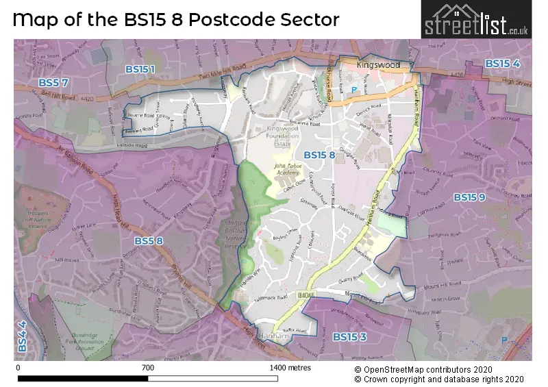
Map of the BS15 8 Postcode Sector
Explore the BS15 8 postcode sector by using our free interactive map.
| B | S | 1 | 5 | - | 8 | X | X |
| B | S | 1 | 5 | Space | 8 | Letter | Letter |
Official List of Streets
BRISTOL (47 Streets)
Kingswood (31 Streets)
Hanham (12 Streets)
Unofficial Streets or Alternative Spellings
Kingswood
COURT ROAD DOWNEND ROAD ORCHARD ROAD PARK ROAD WOODLAND TERRACEBRISTOL
ABBOTSWOOD CLAYPOOL ROAD HILLBURN ROAD LONDON STREET TWO MILE HILL ROADHanham
HIGH STREET WOODYLEAZE DRIVE BRYANTS HILL ELLESMERE ROAD HOPPS ROAD KINGS CHASE SHOPPING CENTRE KINGS COURT MORAVIAN COURT NEWENT COURT POWS ROAD THE MOUNT WINWOOD COURTWeather Forecast for BS15 8
Press Button to Show Forecast for Kingswood
| Time Period | Icon | Description | Temperature | Rain Probability | Wind |
|---|---|---|---|---|---|
| 06:00 to 09:00 | Cloudy | 5.0°C (feels like 4.0°C) | 4.00% | SW 4 mph | |
| 09:00 to 12:00 | Cloudy | 8.0°C (feels like 6.0°C) | 30.00% | W 9 mph | |
| 12:00 to 15:00 | Cloudy | 11.0°C (feels like 9.0°C) | 12.00% | WNW 9 mph | |
| 15:00 to 18:00 | Cloudy | 11.0°C (feels like 10.0°C) | 10.00% | W 7 mph | |
| 18:00 to 21:00 | Cloudy | 10.0°C (feels like 9.0°C) | 6.00% | NNW 7 mph | |
| 21:00 to 00:00 | Cloudy | 8.0°C (feels like 6.0°C) | 5.00% | NE 7 mph |
Press Button to Show Forecast for Kingswood
| Time Period | Icon | Description | Temperature | Rain Probability | Wind |
|---|---|---|---|---|---|
| 00:00 to 03:00 | Cloudy | 7.0°C (feels like 5.0°C) | 5.00% | NE 4 mph | |
| 03:00 to 06:00 | Cloudy | 6.0°C (feels like 4.0°C) | 6.00% | ENE 7 mph | |
| 06:00 to 09:00 | Overcast | 5.0°C (feels like 3.0°C) | 10.00% | ENE 7 mph | |
| 09:00 to 12:00 | Cloudy | 7.0°C (feels like 5.0°C) | 9.00% | E 9 mph | |
| 12:00 to 15:00 | Overcast | 10.0°C (feels like 7.0°C) | 14.00% | E 9 mph | |
| 15:00 to 18:00 | Overcast | 10.0°C (feels like 8.0°C) | 18.00% | E 9 mph | |
| 18:00 to 21:00 | Overcast | 9.0°C (feels like 7.0°C) | 19.00% | E 7 mph | |
| 21:00 to 00:00 | Cloudy | 7.0°C (feels like 5.0°C) | 16.00% | E 7 mph |
Press Button to Show Forecast for Kingswood
| Time Period | Icon | Description | Temperature | Rain Probability | Wind |
|---|---|---|---|---|---|
| 00:00 to 03:00 | Cloudy | 6.0°C (feels like 4.0°C) | 13.00% | ENE 7 mph | |
| 03:00 to 06:00 | Overcast | 5.0°C (feels like 3.0°C) | 20.00% | ENE 7 mph | |
| 06:00 to 09:00 | Overcast | 5.0°C (feels like 2.0°C) | 23.00% | ENE 9 mph | |
| 09:00 to 12:00 | Light rain | 7.0°C (feels like 4.0°C) | 51.00% | ENE 11 mph | |
| 12:00 to 15:00 | Overcast | 10.0°C (feels like 7.0°C) | 21.00% | ENE 11 mph | |
| 15:00 to 18:00 | Cloudy | 11.0°C (feels like 9.0°C) | 18.00% | ENE 11 mph | |
| 18:00 to 21:00 | Light rain | 10.0°C (feels like 8.0°C) | 51.00% | NE 9 mph | |
| 21:00 to 00:00 | Light rain | 8.0°C (feels like 6.0°C) | 50.00% | NE 11 mph |
Press Button to Show Forecast for Kingswood
| Time Period | Icon | Description | Temperature | Rain Probability | Wind |
|---|---|---|---|---|---|
| 00:00 to 03:00 | Light rain | 7.0°C (feels like 5.0°C) | 50.00% | NE 9 mph | |
| 03:00 to 06:00 | Heavy rain | 7.0°C (feels like 4.0°C) | 72.00% | NE 9 mph | |
| 06:00 to 09:00 | Light rain | 7.0°C (feels like 5.0°C) | 53.00% | NE 9 mph | |
| 09:00 to 12:00 | Heavy rain | 9.0°C (feels like 6.0°C) | 72.00% | NNE 9 mph | |
| 12:00 to 15:00 | Light rain shower (day) | 11.0°C (feels like 8.0°C) | 42.00% | WNW 11 mph | |
| 15:00 to 18:00 | Light rain shower (day) | 11.0°C (feels like 9.0°C) | 43.00% | W 11 mph | |
| 18:00 to 21:00 | Light rain shower (day) | 11.0°C (feels like 9.0°C) | 36.00% | NNW 9 mph | |
| 21:00 to 00:00 | Partly cloudy (night) | 8.0°C (feels like 6.0°C) | 5.00% | WSW 7 mph |
Schools and Places of Education Within the BS15 8 Postcode Sector
Beacon Rise Primary School
Community school
Hanham Road, Bristol, South Gloucestershire, BS15 8NU
Head: Mr Chris Thomas
Ofsted Rating: Outstanding
Inspection: 2023-12-06 (141 days ago)
Website: Visit Beacon Rise Primary School Website
Phone: 01454867232
Number of Pupils: 630
John Cabot Academy
Academy sponsor led
Woodside Road, Bristol, , BS15 8BD
Head: Ms Kate Willis
Ofsted Rating: Good
Inspection: 2018-11-28 (1975 days ago)
Website: Visit John Cabot Academy Website
Phone: 01179763000
Number of Pupils: 1247
Our Lady of Lourdes Catholic Primary School
Voluntary aided school
Hanham Road, Bristol, , BS15 8PX
Head: Mr Oliver Bell
Ofsted Rating: Requires improvement
Inspection: 2023-10-19 (189 days ago)
Website: Visit Our Lady of Lourdes Catholic Primary School Website
Phone: 01454867160
Number of Pupils: 174
Two Mile Hill Primary School
Community school
Two Mile Hill Primary School, Bristol, , BS15 8AA
Head: Mr Owen Knowles
Ofsted Rating: Requires improvement
Inspection: 2022-06-22 (673 days ago)
Website: Visit Two Mile Hill Primary School Website
Phone: 01179031932
Number of Pupils: 569
House Prices in the BS15 8 Postcode Sector
| Type of Property | 2018 Average | 2018 Sales | 2017 Average | 2017 Sales | 2016 Average | 2016 Sales | 2015 Average | 2015 Sales |
|---|---|---|---|---|---|---|---|---|
| Detached | £319,354 | 14 | £338,974 | 19 | £332,032 | 14 | £279,500 | 13 |
| Semi-Detached | £269,800 | 30 | £242,740 | 29 | £243,778 | 27 | £215,227 | 30 |
| Terraced | £223,619 | 67 | £227,281 | 70 | £200,838 | 91 | £184,685 | 85 |
| Flats | £171,664 | 48 | £147,610 | 30 | £142,672 | 46 | £134,067 | 29 |
Important Postcodes BS15 8 in the Postcode Sector
BS15 8AA is the postcode for MAIN BUILDING, Two Mile Hill Primary School, Kennard Road, and THE ANNEXE, Two Mile Hill Primary School, Kennard Road
BS15 8BD is the postcode for John Cabot Academy, Woodside Road, John Cabot Academy, Woodside Road, Kingswood, and P16 Central, John Cabot Academy, Woodside Road
BS15 8NJ is the postcode for The Orchard Medical Centre, MacDonald Walk
BS15 8NU is the postcode for AVON BUILDING, Beacon Rise Primary School, Hanham Road, SEVERN BUILDING, Beacon Rise Primary School, Hanham Road, FERN HILL, Beacon Rise Primary School, Hanham Road, and FROME BUILDING, Beacon Rise Primary School, Hanham Road
BS15 8PN is the postcode for Royal Mail, Kingswood Delivery Office, Hanham Road
BS15 8PX is the postcode for Our Lady of Lourdes RC School, Hanham Road
| The BS15 8 Sector is within these Local Authorities |
|
|---|---|
| The BS15 8 Sector is within these Counties |
|
| The BS15 8 Sector is within these Water Company Areas |
|