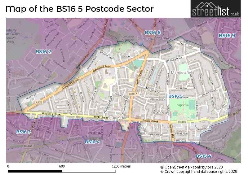
The BS16 5 postcode sector stands on the Bristol and Gloucestershire border.
Did you know? According to the 2021 Census, the BS16 5 postcode sector is home to a bustling 10,841 residents!
Given that each sector allows for 400 unique postcode combinations. Letters C, I, K, M, O and V are not allowed in the last two letters of a postcode. With 252 postcodes already in use, this leaves 148 units available.
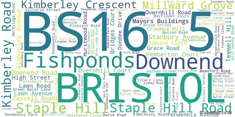
The largest settlement in the BS16 5 postal code is BRISTOL followed by Staple Hill, and Downend.
The BS16 5 Postcode shares a border with BS16 4 (BRISTOL, Staple Hill, Soundwell), BS16 9 (Mangotsfield, Pucklechurch), BS15 4 (BRISTOL, Kingswood, Warmley), BS16 2 (BRISTOL, Fishponds, Frenchay), BS16 3 (BRISTOL, Fishponds) and BS16 6 (BRISTOL, Downend).
The sector is within the post town of BRISTOL.
BS16 5 is a postcode sector within the BS16 postcode district which is within the BS Bristol postcode area.
The Royal Mail delivery office for the BS16 5 postal sector is the Fishponds Delivery Office.
The area of the BS16 5 postcode sector is 0.68 square miles which is 1.76 square kilometres or 434.59 square acres.

Map of the BS16 5 Postcode Sector
Explore the BS16 5 postcode sector by using our free interactive map.
| B | S | 1 | 6 | - | 5 | X | X |
| B | S | 1 | 6 | Space | 5 | Letter | Letter |
Official List of Streets
Staple Hill (24 Streets)
BRISTOL (64 Streets)
Fishponds (3 Streets)
Downend (10 Streets)
Unofficial Streets or Alternative Spellings
Mangotsfield
CHARNHILL DRIVE HILLSIDE MANGOTSFIELD ROAD OLD QUARRY GARDENS VALLEY ROADBRISTOL
ACACIA ROAD IRVING CLOSE LEWINGTON ROAD MAYWOOD CRESCENT MAYWOOD ROAD NARROW LANE OVERNDALE ROAD PAGE ROAD PARTRIDGE DRIVE SOUNDWELL ROAD SUNRIDGE THICKET ROAD VASSALL COURT WOODLANDS RISE BRISTOL & BATH RAILWAY PATH CARPENTERS SHOP LANE GRACE COURT HAYTHORN COURT PAGE COURT PRATTENS LANE SHIPMAN COURT STAPLEHILL ROAD TEEWELL COURT WOODLANDSStaple Hill
EDGEWARE ROAD LOWER STATION ROAD SEYMOUR ROADFishponds
FOREST ROADDownend
CLEEVE ROADEastville
FISHPONDS ROADCoalpit Heath
BADMINTON ROAD WESTERLEIGH ROADWeather Forecast for BS16 5
Press Button to Show Forecast for Staple Hill
| Time Period | Icon | Description | Temperature | Rain Probability | Wind |
|---|---|---|---|---|---|
| 12:00 to 15:00 | Cloudy | 11.0°C (feels like 9.0°C) | 11.00% | WNW 9 mph | |
| 15:00 to 18:00 | Cloudy | 11.0°C (feels like 10.0°C) | 7.00% | W 9 mph | |
| 18:00 to 21:00 | Cloudy | 10.0°C (feels like 9.0°C) | 5.00% | NNW 7 mph | |
| 21:00 to 00:00 | Cloudy | 8.0°C (feels like 6.0°C) | 7.00% | NE 7 mph |
Press Button to Show Forecast for Staple Hill
| Time Period | Icon | Description | Temperature | Rain Probability | Wind |
|---|---|---|---|---|---|
| 00:00 to 03:00 | Cloudy | 7.0°C (feels like 5.0°C) | 5.00% | ENE 4 mph | |
| 03:00 to 06:00 | Cloudy | 6.0°C (feels like 4.0°C) | 6.00% | ENE 7 mph | |
| 06:00 to 09:00 | Cloudy | 5.0°C (feels like 3.0°C) | 7.00% | ENE 7 mph | |
| 09:00 to 12:00 | Cloudy | 8.0°C (feels like 5.0°C) | 9.00% | E 9 mph | |
| 12:00 to 15:00 | Overcast | 10.0°C (feels like 8.0°C) | 14.00% | E 9 mph | |
| 15:00 to 18:00 | Overcast | 10.0°C (feels like 8.0°C) | 18.00% | E 9 mph | |
| 18:00 to 21:00 | Cloudy | 9.0°C (feels like 8.0°C) | 16.00% | E 7 mph | |
| 21:00 to 00:00 | Cloudy | 7.0°C (feels like 6.0°C) | 16.00% | E 7 mph |
Press Button to Show Forecast for Staple Hill
| Time Period | Icon | Description | Temperature | Rain Probability | Wind |
|---|---|---|---|---|---|
| 00:00 to 03:00 | Cloudy | 6.0°C (feels like 4.0°C) | 13.00% | ENE 7 mph | |
| 03:00 to 06:00 | Cloudy | 6.0°C (feels like 3.0°C) | 17.00% | ENE 7 mph | |
| 06:00 to 09:00 | Overcast | 6.0°C (feels like 3.0°C) | 23.00% | ENE 9 mph | |
| 09:00 to 12:00 | Light rain | 7.0°C (feels like 5.0°C) | 51.00% | ENE 11 mph | |
| 12:00 to 15:00 | Overcast | 10.0°C (feels like 7.0°C) | 21.00% | NE 11 mph | |
| 15:00 to 18:00 | Cloudy | 11.0°C (feels like 9.0°C) | 18.00% | ENE 11 mph | |
| 18:00 to 21:00 | Light rain | 10.0°C (feels like 8.0°C) | 51.00% | NE 9 mph | |
| 21:00 to 00:00 | Light rain | 8.0°C (feels like 6.0°C) | 50.00% | NE 11 mph |
Press Button to Show Forecast for Staple Hill
| Time Period | Icon | Description | Temperature | Rain Probability | Wind |
|---|---|---|---|---|---|
| 00:00 to 03:00 | Light rain | 8.0°C (feels like 5.0°C) | 50.00% | NE 11 mph | |
| 03:00 to 06:00 | Heavy rain | 7.0°C (feels like 4.0°C) | 70.00% | NE 9 mph | |
| 06:00 to 09:00 | Light rain | 7.0°C (feels like 5.0°C) | 53.00% | NE 9 mph | |
| 09:00 to 12:00 | Heavy rain | 9.0°C (feels like 6.0°C) | 72.00% | NE 9 mph | |
| 12:00 to 15:00 | Light rain shower (day) | 11.0°C (feels like 8.0°C) | 41.00% | WNW 11 mph | |
| 15:00 to 18:00 | Light rain shower (day) | 11.0°C (feels like 9.0°C) | 43.00% | W 11 mph | |
| 18:00 to 21:00 | Light rain shower (day) | 11.0°C (feels like 9.0°C) | 34.00% | NNW 9 mph | |
| 21:00 to 00:00 | Partly cloudy (night) | 8.0°C (feels like 6.0°C) | 5.00% | S 7 mph |
Schools and Places of Education Within the BS16 5 Postcode Sector
Christ Church, Church of England Infant School, Downend
Voluntary controlled school
Christchurch Avenue, Bristol, , BS16 5TG
Head: Mrs Anna Martin
Ofsted Rating: Good
Inspection: 2023-11-30 (147 days ago)
Website: Visit Christ Church, Church of England Infant School, Downend Website
Phone: 01454866562
Number of Pupils: 224
Christ Church, Church of England Junior School, Downend
Voluntary controlled school
Pendennis Road, Bristol, Gloucestershire, BS16 5JJ
Head: Mrs Pippa Osborne
Ofsted Rating: Good
Inspection: 2019-11-27 (1611 days ago)
Website: Visit Christ Church, Church of England Junior School, Downend Website
Phone: 01454866516
Number of Pupils: 288
House Prices in the BS16 5 Postcode Sector
| Type of Property | 2018 Average | 2018 Sales | 2017 Average | 2017 Sales | 2016 Average | 2016 Sales | 2015 Average | 2015 Sales |
|---|---|---|---|---|---|---|---|---|
| Detached | £427,550 | 10 | £393,071 | 14 | £361,418 | 14 | £318,364 | 18 |
| Semi-Detached | £311,418 | 49 | £311,558 | 52 | £286,475 | 70 | £240,476 | 66 |
| Terraced | £280,173 | 64 | £263,347 | 80 | £257,450 | 87 | £225,027 | 95 |
| Flats | £168,392 | 51 | £203,442 | 60 | £190,209 | 109 | £143,849 | 50 |
Important Postcodes BS16 5 in the Postcode Sector
BS16 5JJ is the postcode for Christchurch Junior School, Pendennis Road
BS16 5LS is the postcode for South Gloucestershire Council, Staple Hill Library, Broad Street
BS16 5TG is the postcode for Christ Church C of E VC Infant School, Christchurch Avenue, and Christ Church C of E VC Infant School, Christchurch Avenue, Downend
BS16 5TW is the postcode for Downend Clinic, Buckingham Gardens, and South Gloucestershire Council, Downend Library, Buckingham Gardens
| The BS16 5 Sector is within these Local Authorities |
|
|---|---|
| The BS16 5 Sector is within these Counties |
|
| The BS16 5 Sector is within these Water Company Areas |
|