The BS16 6 postcode sector is within the county of Gloucestershire.
Did you know? According to the 2021 Census, the BS16 6 postcode sector is home to a bustling 10,943 residents!
Given that each sector allows for 400 unique postcode combinations. Letters C, I, K, M, O and V are not allowed in the last two letters of a postcode. With 261 postcodes already in use, this leaves 139 units available.
The largest settlements in the BS16 6 postal code are BRISTOL and Downend.
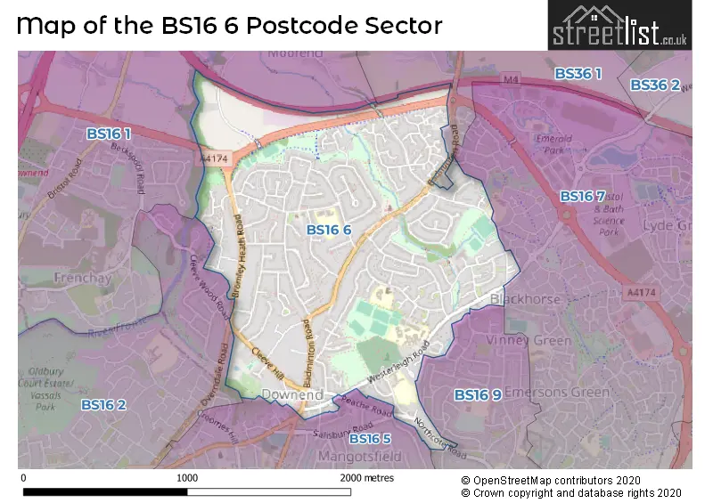
The BS16 6 Postcode shares a border with BS16 9 (Mangotsfield, Pucklechurch), BS36 1 (Winterbourne, Winterbourne Down), BS16 1 (BRISTOL, Stapleton, Hambrook), BS16 2 (BRISTOL, Fishponds, Frenchay), BS16 5 (BRISTOL, Staple Hill, Downend) and BS16 7 (Emersons Green).
The sector is within the post town of BRISTOL.
BS16 6 is a postcode sector within the BS16 postcode district which is within the BS Bristol postcode area.
The Royal Mail delivery office for the BS16 6 postal sector is the Fishponds Delivery Office.
The area of the BS16 6 postcode sector is 1.13 square miles which is 2.92 square kilometres or 721.42 square acres.
The BS16 6 postcode sector is crossed by the M4 motorway.
Waterways within the BS16 6 postcode sector include the River Frome.

Map of the BS16 6 Postcode Sector
Explore the BS16 6 postcode sector by using our free interactive map.
| B | S | 1 | 6 | - | 6 | X | X |
| B | S | 1 | 6 | Space | 6 | Letter | Letter |
Official List of Streets
BRISTOL (84 Streets)
Downend (37 Streets)
Unofficial Streets or Alternative Spellings
BRISTOL
BUCKINGHAM GARDENS CLEEVE WOOD ROAD PEACHE ROADDownend
BUCKINGHAM PLACE SALISBURY ROADEmersons Green
QUARRY WAY TUNBRIDGE WAY WESTONS HILL DRIVEMangotsfield
BLACKHORSE ROAD ELMTREE AVENUE LONG ROAD ROYAL ROAD WINDSOR PLACECoalpit Heath
BADMINTON ROAD WESTERLEIGH ROADWeather Forecast for BS16 6
Press Button to Show Forecast for Downend
| Time Period | Icon | Description | Temperature | Rain Probability | Wind |
|---|---|---|---|---|---|
| 09:00 to 12:00 | Cloudy | 9.0°C (feels like 7.0°C) | 5.00% | N 4 mph | |
| 12:00 to 15:00 | Cloudy | 11.0°C (feels like 9.0°C) | 4.00% | N 7 mph | |
| 15:00 to 18:00 | Partly cloudy (day) | 12.0°C (feels like 11.0°C) | 1.00% | N 9 mph | |
| 18:00 to 21:00 | Sunny day | 11.0°C (feels like 10.0°C) | 0.00% | NNW 7 mph | |
| 21:00 to 00:00 | Clear night | 8.0°C (feels like 7.0°C) | 1.00% | ENE 4 mph |
Press Button to Show Forecast for Downend
| Time Period | Icon | Description | Temperature | Rain Probability | Wind |
|---|---|---|---|---|---|
| 00:00 to 03:00 | Clear night | 6.0°C (feels like 5.0°C) | 1.00% | W 4 mph | |
| 03:00 to 06:00 | Clear night | 4.0°C (feels like 2.0°C) | 1.00% | NW 4 mph | |
| 06:00 to 09:00 | Cloudy | 5.0°C (feels like 3.0°C) | 5.00% | WNW 4 mph | |
| 09:00 to 12:00 | Cloudy | 9.0°C (feels like 7.0°C) | 6.00% | W 7 mph | |
| 12:00 to 15:00 | Overcast | 11.0°C (feels like 9.0°C) | 11.00% | W 9 mph | |
| 15:00 to 18:00 | Cloudy | 12.0°C (feels like 10.0°C) | 8.00% | W 9 mph | |
| 18:00 to 21:00 | Cloudy | 11.0°C (feels like 9.0°C) | 10.00% | WNW 7 mph | |
| 21:00 to 00:00 | Cloudy | 8.0°C (feels like 7.0°C) | 7.00% | WNW 4 mph |
Press Button to Show Forecast for Downend
| Time Period | Icon | Description | Temperature | Rain Probability | Wind |
|---|---|---|---|---|---|
| 00:00 to 03:00 | Cloudy | 6.0°C (feels like 5.0°C) | 8.00% | SSE 4 mph | |
| 03:00 to 06:00 | Cloudy | 6.0°C (feels like 4.0°C) | 9.00% | ENE 4 mph | |
| 06:00 to 09:00 | Cloudy | 6.0°C (feels like 4.0°C) | 12.00% | SE 7 mph | |
| 09:00 to 12:00 | Cloudy | 9.0°C (feels like 7.0°C) | 15.00% | SSE 7 mph | |
| 12:00 to 15:00 | Overcast | 11.0°C (feels like 9.0°C) | 19.00% | SSE 9 mph | |
| 15:00 to 18:00 | Light rain shower (day) | 11.0°C (feels like 9.0°C) | 39.00% | SSE 7 mph | |
| 18:00 to 21:00 | Light rain | 10.0°C (feels like 8.0°C) | 50.00% | SSE 7 mph | |
| 21:00 to 00:00 | Cloudy | 8.0°C (feels like 6.0°C) | 18.00% | ESE 7 mph |
Press Button to Show Forecast for Downend
| Time Period | Icon | Description | Temperature | Rain Probability | Wind |
|---|---|---|---|---|---|
| 00:00 to 03:00 | Overcast | 7.0°C (feels like 5.0°C) | 21.00% | E 7 mph | |
| 03:00 to 06:00 | Cloudy | 7.0°C (feels like 4.0°C) | 18.00% | E 7 mph | |
| 06:00 to 09:00 | Cloudy | 7.0°C (feels like 5.0°C) | 17.00% | NE 7 mph | |
| 09:00 to 12:00 | Cloudy | 10.0°C (feels like 8.0°C) | 14.00% | NE 9 mph | |
| 12:00 to 15:00 | Light rain | 12.0°C (feels like 10.0°C) | 51.00% | NE 9 mph | |
| 15:00 to 18:00 | Cloudy | 12.0°C (feels like 10.0°C) | 22.00% | NNE 9 mph | |
| 18:00 to 21:00 | Light rain shower (day) | 11.0°C (feels like 9.0°C) | 36.00% | NNE 9 mph | |
| 21:00 to 00:00 | Cloudy | 9.0°C (feels like 8.0°C) | 18.00% | N 9 mph |
Schools and Places of Education Within the BS16 6 Postcode Sector
Bromley Heath Infant School
Community school
Quakers Road, Bristol, South Gloucestershire, BS16 6NJ
Head: Mrs Abigail Perry-Hodge
Ofsted Rating: Outstanding
Inspection: 2023-01-18 (462 days ago)
Website: Visit Bromley Heath Infant School Website
Phone: 01454866777
Number of Pupils: 181
Bromley Heath Junior School
Community school
Quakers Road, Bristol, South Gloucestershire, BS16 6NJ
Head: Mrs Tracy Serle
Ofsted Rating: Outstanding
Inspection: 2015-03-13 (3330 days ago)
Website: Visit Bromley Heath Junior School Website
Phone: 01454867110
Number of Pupils: 233
Downend School
Academy converter
Westerleigh Road, Bristol, , BS16 6XA
Head: Miss Linda Ferris
Ofsted Rating: Good
Inspection: 2019-01-09 (1932 days ago)
Website: Visit Downend School Website
Phone: 01454862300
Number of Pupils: 1361
St Augustine of Canterbury Catholic Primary School
Voluntary aided school
Boscombe Crescent, Bristol, , BS16 6QR
Head: Mr Mark Hilliam
Ofsted Rating: Good
Inspection: 2021-09-16 (951 days ago)
Website: Visit St Augustine of Canterbury Catholic Primary School Website
Phone: 01454866690
Number of Pupils: 177
House Prices in the BS16 6 Postcode Sector
| Type of Property | 2018 Average | 2018 Sales | 2017 Average | 2017 Sales | 2016 Average | 2016 Sales | 2015 Average | 2015 Sales |
|---|---|---|---|---|---|---|---|---|
| Detached | £412,954 | 44 | £434,176 | 48 | £389,913 | 47 | £350,050 | 35 |
| Semi-Detached | £350,089 | 70 | £327,810 | 65 | £313,660 | 72 | £282,643 | 63 |
| Terraced | £281,412 | 49 | £275,393 | 39 | £271,175 | 40 | £221,871 | 48 |
| Flats | £146,250 | 8 | £166,653 | 13 | £152,708 | 12 | £130,732 | 19 |
Important Postcodes BS16 6 in the Postcode Sector
BS16 6AL is the postcode for Stanbridge Primary School, Stanbridge Road
BS16 6NJ is the postcode for Bromley Heath Junior School, Quakers Road
BS16 6QR is the postcode for St. Augustine of Canterbury RC Primary School, Boscombe Crescent, and St. Augustines of Canterbury RC Primary School, Boscombe Crescent
BS16 6QW is the postcode for King George V Playing Field And Pavilion, Sutherland Avenue
BS16 6TR is the postcode for Blackhorse Primary School, Blackhorse Lane
BS16 6UG is the postcode for Leap Valley Medical Centre, Beaufort Road
BS16 6XA is the postcode for DRAMA, Downend School, Westerleigh Road, HUMANITIES AND TECHNOLOGY BLOCK, Downend School, Westerleigh Road, SPORTS CENTRE, Downend School, Westerleigh Road, SCIENCE BLOCK, Downend School, Westerleigh Road, and MAIN BLOCK, Downend School, Westerleigh Road
| The BS16 6 Sector is within these Local Authorities |
|
|---|---|
| The BS16 6 Sector is within these Counties |
|
| The BS16 6 Sector is within these Water Company Areas |
|