The BS2 9 postcode sector is within the county of Bristol.
Did you know? According to the 2021 Census, the BS2 9 postcode sector is home to a bustling 6,912 residents!
Given that each sector allows for 400 unique postcode combinations. Letters C, I, K, M, O and V are not allowed in the last two letters of a postcode. With 184 postcodes already in use, this leaves 216 units available.
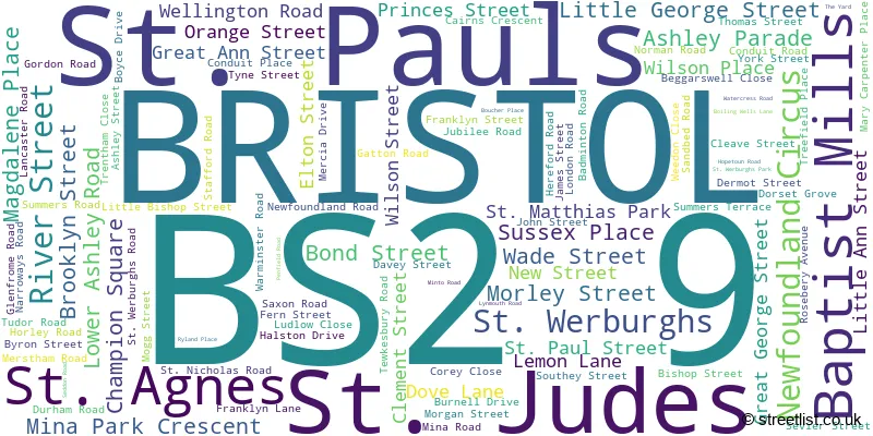
The largest settlement in the BS2 9 postal code is BRISTOL followed by St. Pauls, and St. Agnes.
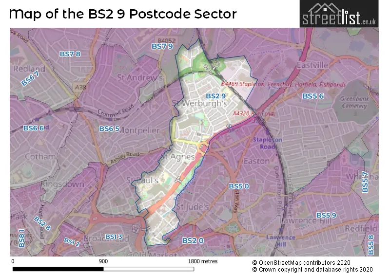
The BS2 9 Postcode shares a border with BS1 3 (BRISTOL), BS7 9 (BRISTOL, Bishopston, Horfield), BS2 0 (BRISTOL, St. Philips), BS2 8 (BRISTOL, Kingsdown, St. Pauls), BS5 0 (BRISTOL, Easton, Lawrence Hill), BS5 6 (BRISTOL, Eastville, Easton) and BS6 5 (BRISTOL, St. Andrews, Montpelier).
The sector is within the post town of BRISTOL.
BS2 9 is a postcode sector within the BS2 postcode district which is within the BS Bristol postcode area.
The Royal Mail delivery office for the BS2 9 postal sector is the Bristol East Central Delivery Office.
The area of the BS2 9 postcode sector is 0.38 square miles which is 0.98 square kilometres or 242.72 square acres.
The BS2 9 postcode sector is crossed by the M32 motorway.
Waterways within the BS2 9 postcode sector include the River Frome.

Map of the BS2 9 Postcode Sector
Explore the BS2 9 postcode sector by using our free interactive map.
| B | S | 2 | - | 9 | X | X |
| B | S | 2 | Space | 9 | Letter | Letter |
Official List of Streets
BRISTOL (83 Streets)
St. Pauls (12 Streets)
St. Werburghs (5 Streets)
St. Judes (1 Streets)
Baptist Mills (1 Streets)
St. Agnes (1 Streets)
Unofficial Streets or Alternative Spellings
BRISTOL
ALBANY ROAD ASHLEY HILL ASHLEY ROAD BOND STREET SOUTH EASTGATE ROAD GROSVENOR ROAD LAMB STREET MILVERTON GARDENS NORFOLK AVENUE PORTLAND SQUARE REDCROSS STREET WILDER STREETEastville
GLENFROME ROAD ASHER LANE DALE STREET HOULTON STREET NARROWAYS FOOTBRIDGE NEW GATTON ROAD NEWFOUNDLAND WAY PEEL STREET ROSEBERY COURT SAINT MATTHIAS PARK SAINT NICHOLAS ROAD SAINT PAUL STREET SAINT WERBURGHS PARK ST PAULS ROUNDABOUT STONEY LANE TUCKER STREETEaston
LOWER ASHLEY ROADWeather Forecast for BS2 9
Press Button to Show Forecast for Ashley Down
| Time Period | Icon | Description | Temperature | Rain Probability | Wind |
|---|---|---|---|---|---|
| 09:00 to 12:00 | Light rain shower (day) | 9.0°C (feels like 7.0°C) | 31.00% | W 7 mph | |
| 12:00 to 15:00 | Cloudy | 11.0°C (feels like 10.0°C) | 9.00% | W 9 mph | |
| 15:00 to 18:00 | Cloudy | 12.0°C (feels like 10.0°C) | 6.00% | WNW 7 mph | |
| 18:00 to 21:00 | Cloudy | 11.0°C (feels like 9.0°C) | 5.00% | NNW 7 mph | |
| 21:00 to 00:00 | Cloudy | 9.0°C (feels like 7.0°C) | 5.00% | NE 7 mph |
Press Button to Show Forecast for Ashley Down
| Time Period | Icon | Description | Temperature | Rain Probability | Wind |
|---|---|---|---|---|---|
| 00:00 to 03:00 | Cloudy | 7.0°C (feels like 6.0°C) | 5.00% | NE 4 mph | |
| 03:00 to 06:00 | Overcast | 6.0°C (feels like 5.0°C) | 8.00% | ENE 4 mph | |
| 06:00 to 09:00 | Cloudy | 6.0°C (feels like 4.0°C) | 8.00% | ENE 7 mph | |
| 09:00 to 12:00 | Cloudy | 8.0°C (feels like 5.0°C) | 10.00% | E 9 mph | |
| 12:00 to 15:00 | Overcast | 10.0°C (feels like 8.0°C) | 15.00% | E 9 mph | |
| 15:00 to 18:00 | Overcast | 10.0°C (feels like 9.0°C) | 19.00% | E 9 mph | |
| 18:00 to 21:00 | Overcast | 10.0°C (feels like 8.0°C) | 20.00% | ENE 7 mph | |
| 21:00 to 00:00 | Cloudy | 8.0°C (feels like 6.0°C) | 16.00% | ENE 7 mph |
Press Button to Show Forecast for Ashley Down
| Time Period | Icon | Description | Temperature | Rain Probability | Wind |
|---|---|---|---|---|---|
| 00:00 to 03:00 | Cloudy | 7.0°C (feels like 5.0°C) | 14.00% | ENE 7 mph | |
| 03:00 to 06:00 | Cloudy | 6.0°C (feels like 4.0°C) | 14.00% | ENE 7 mph | |
| 06:00 to 09:00 | Cloudy | 6.0°C (feels like 3.0°C) | 19.00% | ENE 9 mph | |
| 09:00 to 12:00 | Light rain | 7.0°C (feels like 5.0°C) | 50.00% | ENE 11 mph | |
| 12:00 to 15:00 | Overcast | 10.0°C (feels like 7.0°C) | 21.00% | ENE 11 mph | |
| 15:00 to 18:00 | Cloudy | 11.0°C (feels like 9.0°C) | 16.00% | ENE 11 mph | |
| 18:00 to 21:00 | Overcast | 10.0°C (feels like 8.0°C) | 22.00% | NE 9 mph | |
| 21:00 to 00:00 | Light rain | 9.0°C (feels like 6.0°C) | 48.00% | NE 11 mph |
Press Button to Show Forecast for Ashley Down
| Time Period | Icon | Description | Temperature | Rain Probability | Wind |
|---|---|---|---|---|---|
| 00:00 to 03:00 | Light rain | 8.0°C (feels like 5.0°C) | 51.00% | NE 9 mph | |
| 03:00 to 06:00 | Light rain | 7.0°C (feels like 5.0°C) | 50.00% | NE 9 mph | |
| 06:00 to 09:00 | Light rain | 7.0°C (feels like 5.0°C) | 52.00% | NNE 9 mph | |
| 09:00 to 12:00 | Light rain | 9.0°C (feels like 6.0°C) | 52.00% | NNE 9 mph | |
| 12:00 to 15:00 | Light rain shower (day) | 11.0°C (feels like 9.0°C) | 45.00% | NNW 11 mph | |
| 15:00 to 18:00 | Light rain shower (day) | 11.0°C (feels like 9.0°C) | 43.00% | NW 11 mph | |
| 18:00 to 21:00 | Light rain shower (day) | 11.0°C (feels like 9.0°C) | 35.00% | NNW 9 mph | |
| 21:00 to 00:00 | Partly cloudy (night) | 9.0°C (feels like 7.0°C) | 7.00% | NW 7 mph |
Schools and Places of Education Within the BS2 9 Postcode Sector
St Pauls Nursery School & Children's Centre
Local authority nursery school
Little Bishop Street, Bristol, , BS2 9JF
Head: Ms Lucy Driver
Ofsted Rating: Outstanding
Inspection: 2019-02-12 (1899 days ago)
Website: Visit St Pauls Nursery School & Children's Centre Website
Phone: 01179030337
Number of Pupils: 120
St Werburghs Park Nursery School
Local authority nursery school
Glenfrome Road, Bristol, , BS2 9UX
Head: Headteacher Catherine Bolam
Ofsted Rating: Good
Inspection: 2018-11-20 (1983 days ago)
Website: Visit St Werburghs Park Nursery School Website
Phone: 01179030323
Number of Pupils: 101
House Prices in the BS2 9 Postcode Sector
| Type of Property | 2018 Average | 2018 Sales | 2017 Average | 2017 Sales | 2016 Average | 2016 Sales | 2015 Average | 2015 Sales |
|---|---|---|---|---|---|---|---|---|
| Detached | £262,500 | 1 | £0 | 0 | £0 | 0 | £0 | 0 |
| Semi-Detached | £452,067 | 3 | £371,140 | 5 | £275,000 | 2 | £0 | 0 |
| Terraced | £323,980 | 49 | £322,299 | 46 | £305,790 | 62 | £251,905 | 67 |
| Flats | £203,347 | 15 | £187,772 | 11 | £198,787 | 15 | £146,368 | 22 |
Important Postcodes BS2 9 in the Postcode Sector
BS2 9DT is the postcode for Rosemary Early Years Centre, Haviland House, Great Ann Street
BS2 9JA is the postcode for Bristol City Council, Welsman, Princes Street, and Welsman Office, Princes Street, St Pauls
BS2 9JE is the postcode for Cabot Primary School, Halston Drive
BS2 9JF is the postcode for St. Pauls Nursery School & Childrens Centre, Little Bishop Street
BS2 9NH is the postcode for St. Pauls Community Sports Academy, Newfoundland Road
BS2 9RU is the postcode for Brookland Hall, Conduit Place
BS2 9UB is the postcode for St. Werburghs Primary School, Silver Birch Annexe, Mogg Street, and St Werburghs Primary School, Silver Birch Annex, Mogg Street
BS2 9US is the postcode for St. Werburghs Primary School, James Street, St. Werburghs, and St. Werburghs Primary School, James Street
BS2 9UX is the postcode for St. Werburghs Park Nursery School, Glenfrome Road
| The BS2 9 Sector is within these Local Authorities |
|
|---|---|
| The BS2 9 Sector is within these Counties |
|
| The BS2 9 Sector is within these Water Company Areas |
|