The BS28 postcode district is a postal district located in the BS Bristol postcode area with a population of 3,316 residents according to the 2021 England and Wales Census.
The area of the BS28 postcode district is 16.89 square miles which is 43.73 square kilometres or 10,806.55 acres.
Currently, the BS28 district has about 192 postcode units spread across 1 geographic postcode sectors.
Given that each sector allows for 400 unique postcode combinations, the district has a capacity of 400 postcodes. With 192 postcodes already in use, this leaves 208 units available.
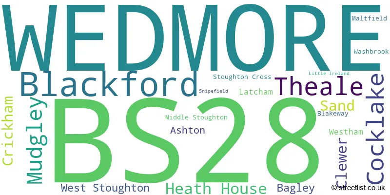
The largest settlement in the BS28 postal code is WEDMORE followed by Blackford, and Theale.
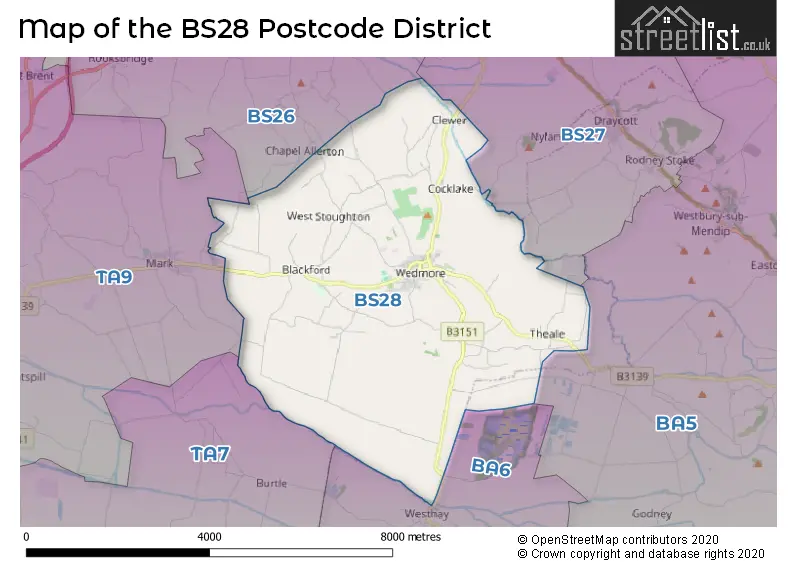
The BS28 Postcode shares a border with BA5 (WELLS, Wookey, Westbury Sub Mendip), BA6 (GLASTONBURY, Baltonsborough, Meare), BS27 (CHEDDAR, Draycott, Rodney Stoke) and TA9 (HIGHBRIDGE, Mark, West Huntspill).
The primary settlement in the BS28 postcode district is Wedmore in Somerset, the county of Somerset lies within England. Other significant settlements in the district include Ashton, Bagley, Blackford, Clewer, Cocklake, Crickham, Heath House, Latcham, Little Ireland, Maltfield, Middle Stoughton, Mudgley, Sand, Snipefield, Stoughton Cross, Theale, Washbrook, West Stoughton, and Westham. The most significant post town in the district is Wedmore.
For the district BS28, we have data on 1 postcode sectors. Here's a breakdown: The sector BS28 4, covers Wedmore and Blackford in Somerset.
BS28 Postcode Sectors

Map of the BS28 Postcode District
Explore the BS28 postcode district by using our free interactive map.
When it comes to local government, postal geography often disregards political borders. However, for a breakdown in the BS28 District: the district mostly encompasses the Somerset area with a total of 202 postcodes.
Weather Forecast for BS28
Press Button to Show Forecast for Wedmore
| Time Period | Icon | Description | Temperature | Rain Probability | Wind |
|---|---|---|---|---|---|
| 00:00 to 03:00 | Cloudy | 10.0°C (feels like 7.0°C) | 6.00% | W 13 mph | |
| 03:00 to 06:00 | Overcast | 10.0°C (feels like 7.0°C) | 9.00% | WNW 13 mph | |
| 06:00 to 09:00 | Cloudy | 9.0°C (feels like 7.0°C) | 5.00% | WNW 11 mph | |
| 09:00 to 12:00 | Cloudy | 12.0°C (feels like 9.0°C) | 5.00% | NW 16 mph | |
| 12:00 to 15:00 | Cloudy | 13.0°C (feels like 9.0°C) | 8.00% | NW 16 mph | |
| 15:00 to 18:00 | Cloudy | 13.0°C (feels like 10.0°C) | 4.00% | NNW 16 mph | |
| 18:00 to 21:00 | Cloudy | 12.0°C (feels like 9.0°C) | 4.00% | N 11 mph | |
| 21:00 to 00:00 | Clear night | 7.0°C (feels like 5.0°C) | 1.00% | N 7 mph |
Press Button to Show Forecast for Wedmore
| Time Period | Icon | Description | Temperature | Rain Probability | Wind |
|---|---|---|---|---|---|
| 00:00 to 03:00 | Clear night | 6.0°C (feels like 4.0°C) | 1.00% | N 7 mph | |
| 03:00 to 06:00 | Clear night | 3.0°C (feels like 2.0°C) | 1.00% | NE 4 mph | |
| 06:00 to 09:00 | Cloudy | 4.0°C (feels like 3.0°C) | 5.00% | ENE 4 mph | |
| 09:00 to 12:00 | Cloudy | 9.0°C (feels like 7.0°C) | 5.00% | NE 7 mph | |
| 12:00 to 15:00 | Overcast | 11.0°C (feels like 9.0°C) | 8.00% | NNE 7 mph | |
| 15:00 to 18:00 | Cloudy | 12.0°C (feels like 10.0°C) | 5.00% | N 9 mph | |
| 18:00 to 21:00 | Partly cloudy (day) | 11.0°C (feels like 9.0°C) | 2.00% | N 7 mph | |
| 21:00 to 00:00 | Clear night | 7.0°C (feels like 5.0°C) | 2.00% | NNE 4 mph |
Press Button to Show Forecast for Wedmore
| Time Period | Icon | Description | Temperature | Rain Probability | Wind |
|---|---|---|---|---|---|
| 00:00 to 03:00 | Clear night | 5.0°C (feels like 3.0°C) | 1.00% | E 4 mph | |
| 03:00 to 06:00 | Clear night | 3.0°C (feels like 2.0°C) | 1.00% | E 2 mph | |
| 06:00 to 09:00 | Sunny day | 5.0°C (feels like 3.0°C) | 1.00% | ENE 4 mph | |
| 09:00 to 12:00 | Partly cloudy (day) | 10.0°C (feels like 8.0°C) | 1.00% | N 7 mph | |
| 12:00 to 15:00 | Overcast | 12.0°C (feels like 10.0°C) | 8.00% | NNE 9 mph | |
| 15:00 to 18:00 | Overcast | 12.0°C (feels like 10.0°C) | 9.00% | NNE 9 mph | |
| 18:00 to 21:00 | Overcast | 11.0°C (feels like 10.0°C) | 10.00% | NNE 7 mph | |
| 21:00 to 00:00 | Clear night | 8.0°C (feels like 7.0°C) | 2.00% | NE 7 mph |
Press Button to Show Forecast for Wedmore
| Time Period | Icon | Description | Temperature | Rain Probability | Wind |
|---|---|---|---|---|---|
| 00:00 to 03:00 | Partly cloudy (night) | 7.0°C (feels like 5.0°C) | 2.00% | NE 7 mph | |
| 03:00 to 06:00 | Clear night | 5.0°C (feels like 2.0°C) | 1.00% | NE 7 mph | |
| 06:00 to 09:00 | Partly cloudy (day) | 5.0°C (feels like 3.0°C) | 1.00% | NE 7 mph | |
| 09:00 to 12:00 | Partly cloudy (day) | 9.0°C (feels like 7.0°C) | 2.00% | NNE 9 mph | |
| 12:00 to 15:00 | Overcast | 11.0°C (feels like 9.0°C) | 9.00% | NE 9 mph | |
| 15:00 to 18:00 | Cloudy | 11.0°C (feels like 9.0°C) | 7.00% | NE 11 mph | |
| 18:00 to 21:00 | Cloudy | 10.0°C (feels like 8.0°C) | 15.00% | NNE 9 mph | |
| 21:00 to 00:00 | Clear night | 7.0°C (feels like 5.0°C) | 2.00% | NNE 7 mph |
Where is the BS28 Postcode District?
The data suggests that the postcode district for BS28 is located in the town of Wedmore. Wedmore is a district town that is situated near several nearby towns. To the North East is Cheddar, which is approximately 4.18 miles away. To the North is Axbridge, located around 4.42 miles away. To the West is Highbridge, which is about 6.69 miles away. To the South East is Glastonbury, located approximately 6.87 miles away. Lastly, to the South West is Bridgwater, which is about 9.79 miles away. Additionally, the postcode district of BS28 is about 118.13 miles away from the center of London.
The district is within the post town of WEDMORE.
The sector has postcodes within the nation of England.
The BS28 Postcode District is covers the following regions.
- Somerset - Dorset and Somerset - South West (England)
- Bath and North East Somerset, North Somerset and South Gloucestershire - Gloucestershire, Wiltshire and Bath/Bristol area - South West (England)
Postcode Sectors within the BS28 District
| Postcode Sector | Delivery Office |
|---|---|
| BS28 4 | Wedmore Scale Payment Delivery Office |
| B | S | 2 | 8 | - | X | X | X |
| B | S | 2 | 8 | Space | Numeric | Letter | Letter |
Current Monthly Rental Prices
| # Bedrooms | Min Price | Max Price | Avg Price |
|---|---|---|---|
| 3 | £1,300 | £1,300 | £1,300 |
| 4 | £1,900 | £2,500 | £2,200 |
| 5 | £2,950 | £2,950 | £2,950 |
Current House Prices
| # Bedrooms | Min Price | Max Price | Avg Price |
|---|---|---|---|
| 2 | £645,000 | £825,000 | £735,000 |
| 3 | £650,000 | £815,000 | £735,000 |
| 4 | £670,000 | £2,150,000 | £1,015,000 |
| 5 | £700,000 | £1,750,000 | £1,070,000 |
| 6 | £900,000 | £1,750,000 | £1,375,000 |
| 12 | £1,850,000 | £1,850,000 | £1,850,000 |
Estate Agents who Operate in the BS28 District
| Logo | Name | Brand Name | Address | Contact Number | Total Properties |
|---|---|---|---|---|---|
 | Wedmore | Cooper & Tanner | Providence House The Borough, Wedmore, BS28 4EG | 01934 311718 | 21 |
 | Cheddar | Laurel & Wylde | 2 Bath Street, Cheddar, BS27 3AA | 01934 315048 | 8 |
 | Wells | Roderick Thomas | 1 Priory Road Wells BA5 1SR | 020 3834 7879 | 5 |
 | Yeovil | Greenslade Taylor Hunt | 22 Princes Street, Yeovil, BA20 1EQ | 01935 313621 | 2 |
 | Rooksbridge | Ivy House Letting | Unit C, Mendip Road, Rooksbridge, BS26 2UG | 01934 311966 | 1 |
| Type of Property | 2018 Average | 2018 Sales | 2017 Average | 2017 Sales | 2016 Average | 2016 Sales | 2015 Average | 2015 Sales |
|---|---|---|---|---|---|---|---|---|
| Detached | £526,583 | 31 | £576,897 | 38 | £495,820 | 29 | £527,367 | 30 |
| Semi-Detached | £367,113 | 4 | £343,409 | 11 | £329,875 | 4 | £289,050 | 10 |
| Terraced | £348,333 | 3 | £368,167 | 3 | £278,286 | 7 | £204,833 | 3 |
| Flats | £345,000 | 1 | £255,583 | 6 | £250,000 | 1 | £243,500 | 2 |
Hotels within the Postcode Area
We found 3 hotels and guest houses within the BS28 postcode area