The BS30 6 postcode sector stands on the Gloucestershire and Somerset border.
Did you know? According to the 2021 Census, the BS30 6 postcode sector is home to a bustling 3,901 residents!
Given that each sector allows for 400 unique postcode combinations. Letters C, I, K, M, O and V are not allowed in the last two letters of a postcode. With 132 postcodes already in use, this leaves 268 units available.
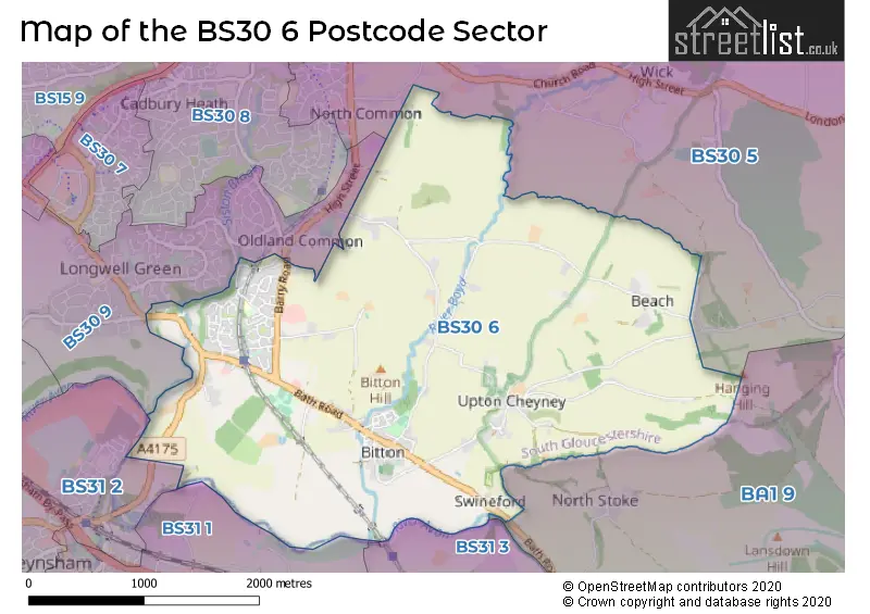
The largest settlement in the BS30 6 postal code is Bitton followed by Willsbridge, and Oldland Common.
The BS30 6 Postcode shares a border with BS30 9 (Longwell Green, Oldland Common, BRISTOL), BS31 1 (Keynsham), BS31 2 (Keynsham), BS31 3 (Saltford), BA1 9 (Lansdown, Kelston, BATH) and BS30 5 (Wick, BRISTOL, Warmley).
The sector is within the post town of BRISTOL.
BS30 6 is a postcode sector within the BS30 postcode district which is within the BS Bristol postcode area.
The Royal Mail delivery office for the BS30 6 postal sector is the Kingswood Delivery Office.
The area of the BS30 6 postcode sector is 4.58 square miles which is 11.86 square kilometres or 2,929.61 square acres.
Waterways within the BS30 6 postcode sector include the River Avon.

Map of the BS30 6 Postcode Sector
Explore the BS30 6 postcode sector by using our free interactive map.
| B | S | 3 | 0 | - | 6 | X | X |
| B | S | 3 | 0 | Space | 6 | Letter | Letter |
Official List of Streets
Bitton (41 Streets)
Oldland Common (11 Streets)
Willsbridge (18 Streets)
Upton Cheyney (7 Streets)
Longwell Green (1 Streets)
BRISTOL (1 Streets)
Unofficial Streets or Alternative Spellings
Weather Forecast for BS30 6
Press Button to Show Forecast for Oldland
| Time Period | Icon | Description | Temperature | Rain Probability | Wind |
|---|---|---|---|---|---|
| 06:00 to 09:00 | Cloudy | 9.0°C (feels like 7.0°C) | 10.00% | WNW 11 mph | |
| 09:00 to 12:00 | Overcast | 11.0°C (feels like 9.0°C) | 10.00% | NW 13 mph | |
| 12:00 to 15:00 | Overcast | 13.0°C (feels like 10.0°C) | 8.00% | NNW 13 mph | |
| 15:00 to 18:00 | Cloudy | 13.0°C (feels like 10.0°C) | 4.00% | NNW 13 mph | |
| 18:00 to 21:00 | Sunny day | 11.0°C (feels like 9.0°C) | 0.00% | N 11 mph | |
| 21:00 to 00:00 | Clear night | 8.0°C (feels like 6.0°C) | 1.00% | N 7 mph |
Press Button to Show Forecast for Oldland
| Time Period | Icon | Description | Temperature | Rain Probability | Wind |
|---|---|---|---|---|---|
| 00:00 to 03:00 | Partly cloudy (night) | 7.0°C (feels like 5.0°C) | 2.00% | N 4 mph | |
| 03:00 to 06:00 | Clear night | 5.0°C (feels like 3.0°C) | 1.00% | NE 4 mph | |
| 06:00 to 09:00 | Cloudy | 5.0°C (feels like 3.0°C) | 4.00% | NE 4 mph | |
| 09:00 to 12:00 | Partly cloudy (day) | 8.0°C (feels like 6.0°C) | 2.00% | NNE 7 mph | |
| 12:00 to 15:00 | Overcast | 10.0°C (feels like 8.0°C) | 8.00% | NNE 9 mph | |
| 15:00 to 18:00 | Overcast | 12.0°C (feels like 10.0°C) | 8.00% | N 9 mph | |
| 18:00 to 21:00 | Partly cloudy (day) | 11.0°C (feels like 9.0°C) | 2.00% | NNE 7 mph | |
| 21:00 to 00:00 | Partly cloudy (night) | 7.0°C (feels like 6.0°C) | 2.00% | ENE 4 mph |
Press Button to Show Forecast for Oldland
| Time Period | Icon | Description | Temperature | Rain Probability | Wind |
|---|---|---|---|---|---|
| 00:00 to 03:00 | Clear night | 5.0°C (feels like 4.0°C) | 1.00% | E 2 mph | |
| 03:00 to 06:00 | Clear night | 4.0°C (feels like 2.0°C) | 1.00% | NE 2 mph | |
| 06:00 to 09:00 | Sunny day | 5.0°C (feels like 4.0°C) | 1.00% | N 4 mph | |
| 09:00 to 12:00 | Partly cloudy (day) | 9.0°C (feels like 8.0°C) | 2.00% | N 7 mph | |
| 12:00 to 15:00 | Overcast | 12.0°C (feels like 10.0°C) | 8.00% | NNE 9 mph | |
| 15:00 to 18:00 | Overcast | 12.0°C (feels like 10.0°C) | 9.00% | NNE 9 mph | |
| 18:00 to 21:00 | Cloudy | 11.0°C (feels like 9.0°C) | 6.00% | NNE 9 mph | |
| 21:00 to 00:00 | Partly cloudy (night) | 9.0°C (feels like 7.0°C) | 1.00% | NE 7 mph |
Press Button to Show Forecast for Oldland
| Time Period | Icon | Description | Temperature | Rain Probability | Wind |
|---|---|---|---|---|---|
| 00:00 to 03:00 | Partly cloudy (night) | 7.0°C (feels like 4.0°C) | 2.00% | NE 7 mph | |
| 03:00 to 06:00 | Clear night | 5.0°C (feels like 3.0°C) | 2.00% | NE 7 mph | |
| 06:00 to 09:00 | Partly cloudy (day) | 5.0°C (feels like 3.0°C) | 1.00% | NNE 7 mph | |
| 09:00 to 12:00 | Cloudy | 9.0°C (feels like 7.0°C) | 6.00% | NE 9 mph | |
| 12:00 to 15:00 | Overcast | 11.0°C (feels like 9.0°C) | 9.00% | NE 9 mph | |
| 15:00 to 18:00 | Cloudy | 11.0°C (feels like 9.0°C) | 15.00% | NNE 11 mph | |
| 18:00 to 21:00 | Cloudy | 10.0°C (feels like 8.0°C) | 14.00% | NNE 9 mph | |
| 21:00 to 00:00 | Partly cloudy (night) | 8.0°C (feels like 6.0°C) | 4.00% | NNE 7 mph |
Schools and Places of Education Within the BS30 6 Postcode Sector
St Anne's Church of England Primary School
Voluntary controlled school
School Road, Bristol, , BS30 6PH
Head: Mr Sean Quinn
Ofsted Rating: Good
Inspection: 2018-11-21 (1976 days ago)
Website: Visit St Anne's Church of England Primary School Website
Phone: 01454862500
Number of Pupils: 383
The Meadows Primary School
Academy sponsor led
Bath Road, Bristol, , BS30 6HS
Head: Mr Owen Edwards
Ofsted Rating: Good
Inspection: 2022-05-11 (709 days ago)
Website: Visit The Meadows Primary School Website
Phone: 01179322203
Number of Pupils: 166
House Prices in the BS30 6 Postcode Sector
| Type of Property | 2018 Average | 2018 Sales | 2017 Average | 2017 Sales | 2016 Average | 2016 Sales | 2015 Average | 2015 Sales |
|---|---|---|---|---|---|---|---|---|
| Detached | £422,941 | 18 | £617,333 | 21 | £485,667 | 21 | £528,692 | 31 |
| Semi-Detached | £298,447 | 15 | £275,204 | 12 | £297,833 | 12 | £315,268 | 11 |
| Terraced | £301,044 | 43 | £231,333 | 9 | £243,609 | 23 | £245,130 | 20 |
| Flats | £203,000 | 12 | £162,000 | 1 | £169,083 | 6 | £113,598 | 8 |
Important Postcodes BS30 6 in the Postcode Sector
BS30 6HS is the postcode for The Meadows Primary School, Bath Road, Bitton, and The Meadows Primary School, Bath Road
BS30 6JH is the postcode for Cherry Garden Primary School, Cherry Garden Lane
BS30 6PH is the postcode for St. Annes C of E Primary School, School Road
| The BS30 6 Sector is within these Local Authorities |
|
|---|---|
| The BS30 6 Sector is within these Counties |
|
| The BS30 6 Sector is within these Water Company Areas |
|