The BS31 2 postcode sector lies where the three counties of Bristol, Gloucestershire, and Somerset meet.
Did you know? According to the 2021 Census, the BS31 2 postcode sector is home to a bustling 11,033 residents!
Given that each sector allows for 400 unique postcode combinations. Letters C, I, K, M, O and V are not allowed in the last two letters of a postcode. With 287 postcodes already in use, this leaves 113 units available.
The BS31 2 postal code covers the settlement of Keynsham.
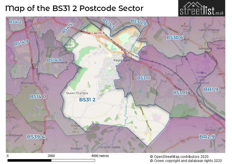
The BS31 2 Postcode shares a border with BA2 9 (Corston, Marksbury, Newton St. Loe), BS4 4 (BRISTOL, St. Annes Park, Brislington), BS14 0 (BRISTOL, Whitchurch, Hawkfield Business Park), BS14 8 (BRISTOL, Stockwood), BS30 9 (Longwell Green, Oldland Common, BRISTOL), BS31 1 (Keynsham), BS31 3 (Saltford), BS15 3 (Hanham, BRISTOL), BS4 5 (BRISTOL, Brislington), BS30 6 (Bitton, Willsbridge, Oldland Common) and BS39 4 (Pensford, Stanton Drew, Compton Dando).
The sector is within the post town of BRISTOL.
BS31 2 is a postcode sector within the BS31 postcode district which is within the BS Bristol postcode area.
The Royal Mail delivery office for the BS31 2 postal sector is the Keynsham Delivery Office.
The area of the BS31 2 postcode sector is 5.76 square miles which is 14.91 square kilometres or 3,685.43 square acres.
Waterways within the BS31 2 postcode sector include the River Avon, River Chew.

Map of the BS31 2 Postcode Sector
Explore the BS31 2 postcode sector by using our free interactive map.
| B | S | 3 | 1 | - | 2 | X | X |
| B | S | 3 | 1 | Space | 2 | Letter | Letter |
Official List of Streets
Keynsham (156 Streets)
Unofficial Streets or Alternative Spellings
Keynsham
BLACKBERRY WAY COURTLANDS DUNSTER ROAD GREENFIELD ROAD HANDEL ROAD HIGH STREET ROCK ROAD THE MEAD ABBOTSWOOD CLOSE BLUEBELL DRIVE BROOKLEAZE BURNETT HILL CHANDOS LODGE MOORINGS DAISY CLOSE DAPWELL LANE ENGINEHOUSE LANE HIGHWALL LANE KEYNSHAM BY-PASS MIDDLEPIECE LANE OLD BURNETT LANE PRIMROSE WALK RING ROAD CYCLE PATH SAINT FRANCIS ROAD SAINT GEORGES ROAD SCOTLAND LANE SEMELE ROAD SOMERDALE ROAD THE DRIVE TREETOPSBrislington
BATH ROADCompton Dando
SLATE LANEBRISTOL
QUEEN CHARLTON LANEWeather Forecast for BS31 2
Press Button to Show Forecast for Keynsham
| Time Period | Icon | Description | Temperature | Rain Probability | Wind |
|---|---|---|---|---|---|
| 21:00 to 00:00 | Cloudy | 8.0°C (feels like 7.0°C) | 5.00% | NE 4 mph |
Press Button to Show Forecast for Keynsham
| Time Period | Icon | Description | Temperature | Rain Probability | Wind |
|---|---|---|---|---|---|
| 00:00 to 03:00 | Cloudy | 7.0°C (feels like 6.0°C) | 5.00% | ENE 4 mph | |
| 03:00 to 06:00 | Cloudy | 6.0°C (feels like 5.0°C) | 6.00% | ENE 4 mph | |
| 06:00 to 09:00 | Overcast | 6.0°C (feels like 4.0°C) | 10.00% | ENE 7 mph | |
| 09:00 to 12:00 | Cloudy | 8.0°C (feels like 6.0°C) | 9.00% | E 9 mph | |
| 12:00 to 15:00 | Overcast | 10.0°C (feels like 8.0°C) | 14.00% | E 9 mph | |
| 15:00 to 18:00 | Overcast | 11.0°C (feels like 9.0°C) | 18.00% | E 9 mph | |
| 18:00 to 21:00 | Overcast | 10.0°C (feels like 8.0°C) | 19.00% | E 7 mph | |
| 21:00 to 00:00 | Cloudy | 8.0°C (feels like 6.0°C) | 16.00% | E 7 mph |
Press Button to Show Forecast for Keynsham
| Time Period | Icon | Description | Temperature | Rain Probability | Wind |
|---|---|---|---|---|---|
| 00:00 to 03:00 | Cloudy | 7.0°C (feels like 5.0°C) | 13.00% | ENE 7 mph | |
| 03:00 to 06:00 | Cloudy | 6.0°C (feels like 4.0°C) | 17.00% | ENE 7 mph | |
| 06:00 to 09:00 | Cloudy | 6.0°C (feels like 3.0°C) | 23.00% | ENE 9 mph | |
| 09:00 to 12:00 | Light rain | 8.0°C (feels like 5.0°C) | 52.00% | ENE 11 mph | |
| 12:00 to 15:00 | Overcast | 10.0°C (feels like 8.0°C) | 21.00% | ENE 11 mph | |
| 15:00 to 18:00 | Cloudy | 11.0°C (feels like 9.0°C) | 18.00% | ENE 11 mph | |
| 18:00 to 21:00 | Overcast | 11.0°C (feels like 8.0°C) | 25.00% | NE 9 mph | |
| 21:00 to 00:00 | Light rain | 9.0°C (feels like 6.0°C) | 50.00% | NE 9 mph |
Press Button to Show Forecast for Keynsham
| Time Period | Icon | Description | Temperature | Rain Probability | Wind |
|---|---|---|---|---|---|
| 00:00 to 03:00 | Light rain | 8.0°C (feels like 6.0°C) | 50.00% | NE 9 mph | |
| 03:00 to 06:00 | Heavy rain | 8.0°C (feels like 5.0°C) | 72.00% | NE 9 mph | |
| 06:00 to 09:00 | Light rain | 8.0°C (feels like 5.0°C) | 53.00% | ENE 9 mph | |
| 09:00 to 12:00 | Heavy rain | 9.0°C (feels like 7.0°C) | 72.00% | NE 9 mph | |
| 12:00 to 15:00 | Light rain | 11.0°C (feels like 9.0°C) | 52.00% | WSW 11 mph | |
| 15:00 to 18:00 | Light rain shower (day) | 12.0°C (feels like 10.0°C) | 42.00% | WSW 11 mph | |
| 18:00 to 21:00 | Light rain shower (day) | 11.0°C (feels like 10.0°C) | 34.00% | W 9 mph | |
| 21:00 to 00:00 | Partly cloudy (night) | 9.0°C (feels like 7.0°C) | 5.00% | SW 7 mph |
Schools and Places of Education Within the BS31 2 Postcode Sector
Broadlands Academy
Academy sponsor led
St Francis Road, Bristol, , BS31 2DY
Head: Mrs Helen Simmons
Ofsted Rating: Good
Inspection: 2023-04-20 (371 days ago)
Website: Visit Broadlands Academy Website
Phone: 01179864791
Number of Pupils: 495
Castle Primary School
Academy sponsor led
Castle Primary School, Newlands Road, Bristol, , BS31 2TS
Head: Mr Chris Cannings
Ofsted Rating: Good
Inspection: 2023-10-04 (204 days ago)
Website: Visit Castle Primary School Website
Phone: 01179864489
Number of Pupils: 328
Somerdale Educate Together Primary Academy
Free schools
Tiberius Road, Keynsham, Somerset, BS31 2FF
Head: Mr Christopher Thomas-Unsworth
Ofsted Rating: Good
Inspection: 2022-03-02 (785 days ago)
Website: Visit Somerdale Educate Together Primary Academy Website
Phone: 01173790888
Number of Pupils: 239
St Keyna Primary School
Community school
Monmouth Road, Bristol, , BS31 2JP
Head: Mr Steve Gumm
Ofsted Rating: Good
Inspection: 2021-09-29 (939 days ago)
Website: Visit St Keyna Primary School Website
Phone: 01179863852
Number of Pupils: 265
House Prices in the BS31 2 Postcode Sector
| Type of Property | 2018 Average | 2018 Sales | 2017 Average | 2017 Sales | 2016 Average | 2016 Sales | 2015 Average | 2015 Sales |
|---|---|---|---|---|---|---|---|---|
| Detached | £491,714 | 48 | £491,722 | 55 | £482,559 | 53 | £422,642 | 38 |
| Semi-Detached | £334,022 | 80 | £343,234 | 90 | £315,225 | 97 | £277,137 | 71 |
| Terraced | £270,343 | 79 | £305,504 | 83 | £265,869 | 79 | £202,669 | 74 |
| Flats | £293,157 | 70 | £295,104 | 92 | £165,404 | 12 | £151,559 | 27 |
Important Postcodes BS31 2 in the Postcode Sector
BS31 2AF is the postcode for Hicks Gate Fire Station, Avon Fire & Rescue Service, Avon Fire & Rescue Service, Hicks Gate Fire Station, and Hicks Gate Fire Station, Durley Hill
BS31 2DY is the postcode for SPORTS HALL, Broadlands School, St. Francis Road, HISTORY BLOCK, Broadlands School, St. Francis Road, MATHS, Broadlands School, St. Francis Road, I-LEARN, Broadlands School, St. Francis Road, ENGLISH BLOCK, Broadlands School, St. Francis Road, and MAIN BUILDING, Broadlands School, St. Francis Road
BS31 2FF is the postcode for Somerdale Educate Together Primary School, Tiberius Road, Keynsham, and Somerdale Educate Together Primary School, Tiberius Road
BS31 2GY is the postcode for Royal Mail, Keynsham Delivery Office, Ashton Way
BS31 2JP is the postcode for St. Keyna Primary School, Monmouth Road, Keynsham, NURSERY UNIT, St Keyna Primary School, Monmouth Road, and St. Keyna Primary School, Monmouth Road
BS31 2NB is the postcode for St. Johns C of E Primary School, Charlton Park, and St. Johns C of E Primary School, Charlton Park, Keynsham
BS31 2TS is the postcode for Castle Primary School, Newlands Road, and NEW FOUR CLASS EXTENSION, Castle Primary School, Newlands Road
| The BS31 2 Sector is within these Local Authorities |
|
|---|---|
| The BS31 2 Sector is within these Counties |
|
| The BS31 2 Sector is within these Water Company Areas |
|