The BS35 2 postcode sector is within the county of Gloucestershire.
Did you know? According to the 2021 Census, the BS35 2 postcode sector is home to a bustling 6,561 residents!
Given that each sector allows for 400 unique postcode combinations. Letters C, I, K, M, O and V are not allowed in the last two letters of a postcode. With 169 postcodes already in use, this leaves 231 units available.
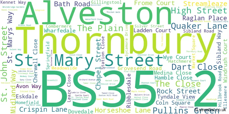
The largest settlements in the BS35 2 postal code are Thornbury and Alveston.
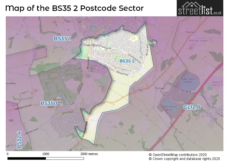
The BS35 2 Postcode shares a border with BS35 1 (Thornbury, Oldbury-on-Severn, Littleton-upon-Severn) and BS35 3 (Alveston, Thornbury, Rudgeway).
The sector is within the post town of BRISTOL.
BS35 2 is a postcode sector within the BS35 postcode district which is within the BS Bristol postcode area.
The Royal Mail delivery office for the BS35 2 postal sector is the Thornbury Delivery Office.
The area of the BS35 2 postcode sector is 1.07 square miles which is 2.78 square kilometres or 686.63 square acres.

Map of the BS35 2 Postcode Sector
Explore the BS35 2 postcode sector by using our free interactive map.
| B | S | 3 | 5 | - | 2 | X | X |
| B | S | 3 | 5 | Space | 2 | Letter | Letter |
Official List of Streets
Thornbury (101 Streets)
Alveston (3 Streets)
Unofficial Streets or Alternative Spellings
Thornbury
BRISTOL ROAD CASTLE STREET CLAY LANE COOPER ROAD CROSSWAYS LANE GLOUCESTER ROAD ABBEY WAY BRIDGE HILL CLOSE CABOT HOUSE COLLESTER WAY DAVIDS LANE LINK ROAD MIDLAND WAY BUSINESS PARK MORTON WAY NEW LANE OLD MARKET STREET OTH/46 SIBLAND SOAPERS LANE STREAMLEAZE COURT STREAMSIDE WALK TANNERS COURTAlveston
COURVILLE CLOSE DAVIDS CLOSE DOWN ROAD GREENHILL ROAD OLD GLOUCESTER ROAD THE MEAD THE STREET THORNBURY HILL WOLFRIDGE RIDEAlmondsbury
GLOUCESTER ROADWeather Forecast for BS35 2
Press Button to Show Forecast for Thornbury
| Time Period | Icon | Description | Temperature | Rain Probability | Wind |
|---|---|---|---|---|---|
| 00:00 to 03:00 | Cloudy | 7.0°C (feels like 5.0°C) | 4.00% | ENE 4 mph | |
| 03:00 to 06:00 | Cloudy | 5.0°C (feels like 4.0°C) | 3.00% | ENE 2 mph | |
| 06:00 to 09:00 | Partly cloudy (day) | 5.0°C (feels like 4.0°C) | 1.00% | E 2 mph | |
| 09:00 to 12:00 | Cloudy | 8.0°C (feels like 7.0°C) | 3.00% | NE 4 mph | |
| 12:00 to 15:00 | Cloudy | 11.0°C (feels like 10.0°C) | 4.00% | N 7 mph | |
| 15:00 to 18:00 | Overcast | 11.0°C (feels like 10.0°C) | 7.00% | NNW 7 mph | |
| 18:00 to 21:00 | Cloudy | 11.0°C (feels like 10.0°C) | 4.00% | NW 7 mph | |
| 21:00 to 00:00 | Cloudy | 8.0°C (feels like 7.0°C) | 7.00% | ENE 4 mph |
Press Button to Show Forecast for Thornbury
| Time Period | Icon | Description | Temperature | Rain Probability | Wind |
|---|---|---|---|---|---|
| 00:00 to 03:00 | Partly cloudy (night) | 7.0°C (feels like 6.0°C) | 1.00% | ENE 2 mph | |
| 03:00 to 06:00 | Clear night | 4.0°C (feels like 3.0°C) | 0.00% | NE 4 mph | |
| 06:00 to 09:00 | Partly cloudy (day) | 5.0°C (feels like 4.0°C) | 1.00% | NE 4 mph | |
| 09:00 to 12:00 | Cloudy | 9.0°C (feels like 7.0°C) | 4.00% | NNE 7 mph | |
| 12:00 to 15:00 | Overcast | 11.0°C (feels like 9.0°C) | 7.00% | NNE 9 mph | |
| 15:00 to 18:00 | Overcast | 11.0°C (feels like 9.0°C) | 9.00% | NNE 9 mph | |
| 18:00 to 21:00 | Overcast | 10.0°C (feels like 8.0°C) | 10.00% | NNE 9 mph | |
| 21:00 to 00:00 | Partly cloudy (night) | 7.0°C (feels like 5.0°C) | 2.00% | NE 7 mph |
Press Button to Show Forecast for Thornbury
| Time Period | Icon | Description | Temperature | Rain Probability | Wind |
|---|---|---|---|---|---|
| 00:00 to 03:00 | Cloudy | 6.0°C (feels like 4.0°C) | 5.00% | ENE 4 mph | |
| 03:00 to 06:00 | Cloudy | 4.0°C (feels like 2.0°C) | 6.00% | NE 4 mph | |
| 06:00 to 09:00 | Cloudy | 4.0°C (feels like 3.0°C) | 8.00% | NE 4 mph | |
| 09:00 to 12:00 | Cloudy | 8.0°C (feels like 7.0°C) | 10.00% | ENE 4 mph | |
| 12:00 to 15:00 | Cloudy | 9.0°C (feels like 8.0°C) | 15.00% | NE 4 mph | |
| 15:00 to 18:00 | Cloudy | 10.0°C (feels like 8.0°C) | 17.00% | ESE 7 mph | |
| 18:00 to 21:00 | Cloudy | 9.0°C (feels like 8.0°C) | 16.00% | N 7 mph | |
| 21:00 to 00:00 | Cloudy | 8.0°C (feels like 6.0°C) | 9.00% | NNE 7 mph |
Press Button to Show Forecast for Thornbury
| Time Period | Icon | Description | Temperature | Rain Probability | Wind |
|---|---|---|---|---|---|
| 00:00 to 03:00 | Cloudy | 7.0°C (feels like 5.0°C) | 7.00% | NNE 7 mph | |
| 03:00 to 06:00 | Cloudy | 6.0°C (feels like 4.0°C) | 6.00% | NE 4 mph | |
| 06:00 to 09:00 | Cloudy | 7.0°C (feels like 5.0°C) | 7.00% | N 4 mph | |
| 09:00 to 12:00 | Cloudy | 9.0°C (feels like 7.0°C) | 9.00% | NNE 7 mph | |
| 12:00 to 15:00 | Cloudy | 12.0°C (feels like 10.0°C) | 10.00% | N 9 mph | |
| 15:00 to 18:00 | Cloudy | 12.0°C (feels like 10.0°C) | 13.00% | N 9 mph | |
| 18:00 to 21:00 | Cloudy | 12.0°C (feels like 10.0°C) | 13.00% | N 7 mph | |
| 21:00 to 00:00 | Overcast | 8.0°C (feels like 7.0°C) | 8.00% | N 7 mph |
Schools and Places of Education Within the BS35 2 Postcode Sector
Crossways Infant School
Community school
Knapp Road, Bristol, South Gloucestershire, BS35 2HQ
Head: Mrs Jo Geoghegan
Ofsted Rating: Requires improvement
Inspection: 2023-10-11 (192 days ago)
Website: Visit Crossways Infant School Website
Phone: 01454866566
Number of Pupils: 180
Crossways Junior School
Community school
Knapp Road, Bristol, South Gloucestershire, BS35 2HQ
Head: Mrs Jo Geoghegan
Ofsted Rating: Good
Inspection: 2023-02-03 (442 days ago)
Website: Visit Crossways Junior School Website
Phone: 01454866566
Number of Pupils: 240
Gillingstool Primary School
Community school
Gillingstool, Bristol, , BS35 2EG
Head: Mrs Caroline Carter
Ofsted Rating: Good
Inspection: 2022-07-13 (647 days ago)
Website: Visit Gillingstool Primary School Website
Phone: 01454866527
Number of Pupils: 166
New Siblands School
Academy special converter
Easton Hill Road, Bristol, , BS35 2JU
Head: Mr Karl Hemmings
Ofsted Rating: Outstanding
Inspection: 2022-11-02 (535 days ago)
Website: Visit New Siblands School Website
Phone: 01454553002
Number of Pupils: 126
St Helen's Church of England Primary School
Voluntary controlled school
Greenhill, Bristol, , BS35 2QX
Head: Mr Kelvin Chappell/Mrs Julie Simpson
Ofsted Rating: Outstanding
Inspection: 2019-12-18 (1585 days ago)
Website: Visit St Helen's Church of England Primary School Website
Phone: 01454866530
Number of Pupils: 204
House Prices in the BS35 2 Postcode Sector
| Type of Property | 2018 Average | 2018 Sales | 2017 Average | 2017 Sales | 2016 Average | 2016 Sales | 2015 Average | 2015 Sales |
|---|---|---|---|---|---|---|---|---|
| Detached | £387,471 | 17 | £408,374 | 27 | £377,113 | 28 | £352,313 | 27 |
| Semi-Detached | £282,476 | 43 | £276,148 | 26 | £259,041 | 23 | £249,013 | 49 |
| Terraced | £266,276 | 38 | £276,693 | 33 | £300,154 | 28 | £191,112 | 36 |
| Flats | £184,400 | 15 | £191,786 | 22 | £190,373 | 22 | £227,954 | 40 |
Important Postcodes BS35 2 in the Postcode Sector
BS35 2AA is the postcode for South Gloucestershire Council, Thornbury Library, St. Mary Street
BS35 2AT is the postcode for Doctors Surgery, 24 St. Mary Street
BS35 2EG is the postcode for Gillingstool Primary & New Siblands School, Gillingstool, Thornbury, and Gillingstool Primary & New Siblands School, Gillingstool
BS35 2HQ is the postcode for Crossways Infants, Knapp Road, Crossways Infants, Knapp Road, Thornbury, Crossways Junior, Knapp Road, Thornbury, and Crossways Junior, Knapp Road
BS35 2JU is the postcode for New Siblands School, Easton Hill Road, and New Siblands School, Easton Hill Road, Thornbury
BS35 2QX is the postcode for St. Helens C of E Primary School, Greenhill, Alveston, and St. Helens C of E Primary School, Greenhill
| The BS35 2 Sector is within these Local Authorities |
|
|---|---|
| The BS35 2 Sector is within these Counties |
|
| The BS35 2 Sector is within these Water Company Areas |
|
Tourist Attractions within the BS35 2 Postcode Area
We found 1 visitor attractions within the BS35 postcode area
| Thornbury and District Museum |
|---|
| Museums & Art Galleries |
| Museum and / or Art Gallery |
| View Thornbury and District Museum on Google Maps |