The BS39 4 postcode sector is within the county of Somerset.
Did you know? According to the 2021 Census, the BS39 4 postcode sector is home to a bustling 2,615 residents!
Given that each sector allows for 400 unique postcode combinations. Letters C, I, K, M, O and V are not allowed in the last two letters of a postcode. With 140 postcodes already in use, this leaves 260 units available.
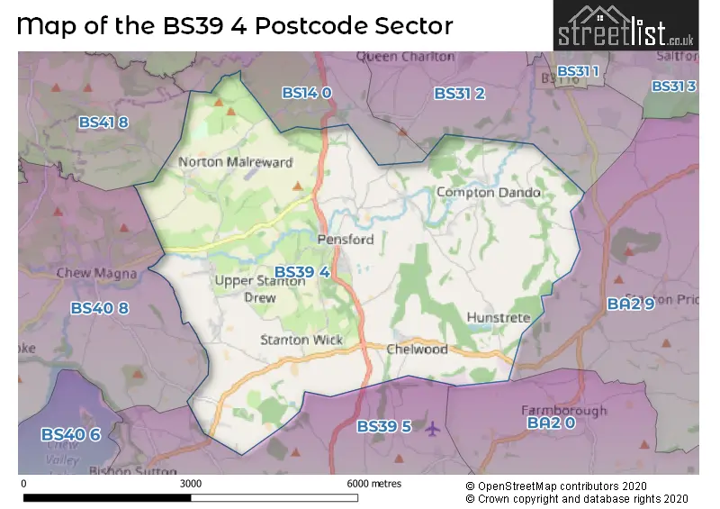
The largest settlement in the BS39 4 postal code is Pensford followed by Stanton Drew, and Compton Dando.
The BS39 4 Postcode shares a border with BA2 9 (Corston, Marksbury, Newton St. Loe), BS14 0 (BRISTOL, Whitchurch, Hawkfield Business Park), BS31 2 (Keynsham), BS39 5 (Clutton, Temple Cloud, Bishop Sutton), BS40 8 (Winford, Chew Magna, Chew Stoke), BA2 0 (Timsbury, Farmborough, Camerton) and BS41 8 (Dundry).
The sector is within the post town of BRISTOL.
BS39 4 is a postcode sector within the BS39 postcode district which is within the BS Bristol postcode area.
The Royal Mail delivery office for the BS39 4 postal sector is the Pensford Scale Payment Delivery Office.
The area of the BS39 4 postcode sector is 12.75 square miles which is 33.03 square kilometres or 8,161.82 square acres.
Waterways within the BS39 4 postcode sector include the River Chew, Chew.

Map of the BS39 4 Postcode Sector
Explore the BS39 4 postcode sector by using our free interactive map.
| B | S | 3 | 9 | - | 4 | X | X |
| B | S | 3 | 9 | Space | 4 | Letter | Letter |
Official List of Streets
Pensford (33 Streets)
Compton Dando (13 Streets)
Stanton Drew (10 Streets)
Chelwood (2 Streets)
Unofficial Streets or Alternative Spellings
Keynsham
CHEWTON ROAD BARN LANE CHELWOOD ROUNDABOUT KINGS COURT COTTAGES MAESKNOLL LANE NORTHWICK ROAD OLD BURNETT LANE PENSFORD OLD ROAD STANTON WICK LANE TUCKINGMILL LANE UPPER STANTONClutton
FEATHERBED LANE LOWER BRISTOL ROADBRISTOL
HURSLEY HILL RINGSPIT LANEChew Magna
MOORLEDGE LANE MOORLEDGE ROAD NORTON LANE STANTON ROADWeather Forecast for BS39 4
Press Button to Show Forecast for Stockwood
| Time Period | Icon | Description | Temperature | Rain Probability | Wind |
|---|---|---|---|---|---|
| 06:00 to 09:00 | Cloudy | 6.0°C (feels like 4.0°C) | 4.00% | WSW 4 mph | |
| 09:00 to 12:00 | Light rain | 8.0°C (feels like 6.0°C) | 38.00% | W 9 mph | |
| 12:00 to 15:00 | Cloudy | 11.0°C (feels like 9.0°C) | 12.00% | WNW 9 mph | |
| 15:00 to 18:00 | Cloudy | 11.0°C (feels like 10.0°C) | 7.00% | WNW 9 mph | |
| 18:00 to 21:00 | Cloudy | 10.0°C (feels like 9.0°C) | 6.00% | NNW 7 mph | |
| 21:00 to 00:00 | Cloudy | 8.0°C (feels like 7.0°C) | 4.00% | NE 7 mph |
Press Button to Show Forecast for Stockwood
| Time Period | Icon | Description | Temperature | Rain Probability | Wind |
|---|---|---|---|---|---|
| 00:00 to 03:00 | Cloudy | 7.0°C (feels like 5.0°C) | 5.00% | ENE 4 mph | |
| 03:00 to 06:00 | Overcast | 6.0°C (feels like 4.0°C) | 9.00% | ENE 4 mph | |
| 06:00 to 09:00 | Cloudy | 6.0°C (feels like 3.0°C) | 8.00% | ENE 7 mph | |
| 09:00 to 12:00 | Cloudy | 8.0°C (feels like 5.0°C) | 11.00% | E 9 mph | |
| 12:00 to 15:00 | Overcast | 9.0°C (feels like 7.0°C) | 15.00% | E 9 mph | |
| 15:00 to 18:00 | Overcast | 10.0°C (feels like 8.0°C) | 19.00% | E 9 mph | |
| 18:00 to 21:00 | Overcast | 9.0°C (feels like 7.0°C) | 19.00% | E 7 mph | |
| 21:00 to 00:00 | Cloudy | 8.0°C (feels like 6.0°C) | 16.00% | ENE 7 mph |
Press Button to Show Forecast for Stockwood
| Time Period | Icon | Description | Temperature | Rain Probability | Wind |
|---|---|---|---|---|---|
| 00:00 to 03:00 | Cloudy | 7.0°C (feels like 4.0°C) | 14.00% | E 7 mph | |
| 03:00 to 06:00 | Cloudy | 6.0°C (feels like 3.0°C) | 14.00% | ENE 7 mph | |
| 06:00 to 09:00 | Cloudy | 6.0°C (feels like 3.0°C) | 18.00% | ENE 9 mph | |
| 09:00 to 12:00 | Overcast | 7.0°C (feels like 4.0°C) | 25.00% | ENE 11 mph | |
| 12:00 to 15:00 | Overcast | 9.0°C (feels like 7.0°C) | 21.00% | ENE 11 mph | |
| 15:00 to 18:00 | Cloudy | 11.0°C (feels like 8.0°C) | 19.00% | ENE 11 mph | |
| 18:00 to 21:00 | Light rain | 10.0°C (feels like 8.0°C) | 48.00% | NE 9 mph | |
| 21:00 to 00:00 | Light rain | 9.0°C (feels like 6.0°C) | 48.00% | NE 11 mph |
Press Button to Show Forecast for Stockwood
| Time Period | Icon | Description | Temperature | Rain Probability | Wind |
|---|---|---|---|---|---|
| 00:00 to 03:00 | Light rain | 8.0°C (feels like 5.0°C) | 51.00% | NE 9 mph | |
| 03:00 to 06:00 | Light rain | 7.0°C (feels like 4.0°C) | 52.00% | NE 9 mph | |
| 06:00 to 09:00 | Light rain | 7.0°C (feels like 5.0°C) | 52.00% | NE 9 mph | |
| 09:00 to 12:00 | Light rain | 9.0°C (feels like 6.0°C) | 50.00% | N 9 mph | |
| 12:00 to 15:00 | Heavy rain shower (day) | 11.0°C (feels like 8.0°C) | 57.00% | WNW 11 mph | |
| 15:00 to 18:00 | Light rain shower (day) | 11.0°C (feels like 9.0°C) | 43.00% | NW 11 mph | |
| 18:00 to 21:00 | Light rain shower (day) | 11.0°C (feels like 9.0°C) | 36.00% | NNW 9 mph | |
| 21:00 to 00:00 | Clear night | 9.0°C (feels like 7.0°C) | 7.00% | NW 7 mph |
Schools and Places of Education Within the BS39 4 Postcode Sector
Pensford Primary School
Academy converter
Pensford Hill, Bristol, Somerset, BS39 4AA
Head: Mr Warrick Barton
Ofsted Rating: Good
Inspection: 2023-06-07 (323 days ago)
Website: Visit Pensford Primary School Website
Phone: 01761490470
Number of Pupils: 99
House Prices in the BS39 4 Postcode Sector
| Type of Property | 2018 Average | 2018 Sales | 2017 Average | 2017 Sales | 2016 Average | 2016 Sales | 2015 Average | 2015 Sales |
|---|---|---|---|---|---|---|---|---|
| Detached | £595,125 | 8 | £570,158 | 12 | £500,388 | 17 | £492,075 | 19 |
| Semi-Detached | £337,600 | 5 | £383,536 | 7 | £296,155 | 11 | £374,458 | 8 |
| Terraced | £264,640 | 5 | £239,667 | 3 | £257,563 | 8 | £256,314 | 7 |
| Flats | £135,000 | 1 | £130,000 | 1 | £199,000 | 1 | £201,700 | 2 |
Important Postcodes BS39 4 in the Postcode Sector
BS39 4AA is the postcode for BLOCK 2, Pensford Primary School, Pensford Hill, and BLOCK 1, Pensford Primary School, Pensford Hill
BS39 4EQ is the postcode for Stanton Drew Primary School, Upper Stanton, Stanton Drew
| The BS39 4 Sector is within these Local Authorities |
|
|---|---|
| The BS39 4 Sector is within these Counties |
|
| The BS39 4 Sector is within these Water Company Areas |
|