The BS4 postcode district is a postal district located in the BS Bristol postcode area with a population of 51,717 residents according to the 2021 England and Wales Census.
The area of the BS4 postcode district is 4.57 square miles which is 11.82 square kilometres or 2,921.66 acres.
Currently, the BS4 district has about 1083 postcode units spread across 18 geographic postcode sectors.
Given that each sector allows for 400 unique postcode combinations, the district has a capacity of 7,200 postcodes. With 1083 postcodes already in use, this leaves 6117 units available.
The largest settlement in the BS4 postal code is BRISTOL followed by Brislington, and Arnos Vale.
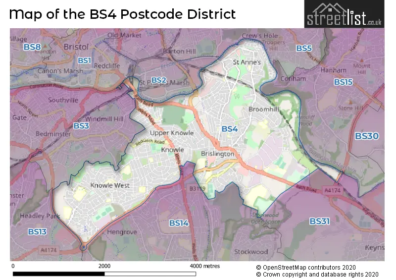
The BS4 Postcode shares a border with BS14 (BRISTOL, Whitchurch), BS3 (BRISTOL, Bedminster, Southville), BS31 (Keynsham, Saltford), BS5 (BRISTOL, St. George, Eastville), BS1 (BRISTOL, Redcliffe), BS15 (BRISTOL, Kingswood, Hanham) and BS2 (BRISTOL, St. Philips, St. Pauls).
The primary settlement in the BS4 postcode district is Bristol, which is located in the county of Bristol in England. Other significant settlements in the district include Knowle, Totterdown, Arnos Vale, Brislington, Pylle Hill, and St. Annes. The most significant post town in the district is Bristol.
For the district BS4, we have data on 6 postcode sectors. Here's a breakdown: The sector BS4 1, covers Bristol in Bristol. The sector BS4 2, covers Bristol in Bristol. The sector BS4 3, covers Bristol and Arnos Vale and Brislington in Bristol. The sector BS4 4, covers Bristol and St. Annes Park in Bristol. The sector BS4 5, covers Bristol in Bristol. The sector BS4 9 is non-geographic. It's often designated for PO Boxes, large organisations, or special services.

Map of the BS4 Postcode District
Explore the BS4 postcode district by using our free interactive map.
When it comes to local government, postal geography often disregards political borders. However, for a breakdown in the BS4 District: the district mostly encompasses the City of Bristol (B) area with a total of 1096 postcodes.
Weather Forecast for BS4
Press Button to Show Forecast for Brislington
| Time Period | Icon | Description | Temperature | Rain Probability | Wind |
|---|---|---|---|---|---|
| 21:00 to 00:00 | Cloudy | 9.0°C (feels like 9.0°C) | 5.00% | SW 4 mph |
Press Button to Show Forecast for Brislington
| Time Period | Icon | Description | Temperature | Rain Probability | Wind |
|---|---|---|---|---|---|
| 00:00 to 03:00 | Partly cloudy (night) | 8.0°C (feels like 7.0°C) | 1.00% | W 4 mph | |
| 03:00 to 06:00 | Clear night | 6.0°C (feels like 4.0°C) | 0.00% | NW 4 mph | |
| 06:00 to 09:00 | Cloudy | 6.0°C (feels like 5.0°C) | 5.00% | SW 4 mph | |
| 09:00 to 12:00 | Cloudy | 9.0°C (feels like 7.0°C) | 27.00% | W 9 mph | |
| 12:00 to 15:00 | Cloudy | 11.0°C (feels like 9.0°C) | 11.00% | W 9 mph | |
| 15:00 to 18:00 | Cloudy | 12.0°C (feels like 10.0°C) | 7.00% | W 9 mph | |
| 18:00 to 21:00 | Cloudy | 11.0°C (feels like 9.0°C) | 5.00% | NNW 7 mph | |
| 21:00 to 00:00 | Cloudy | 9.0°C (feels like 7.0°C) | 5.00% | NE 7 mph |
Press Button to Show Forecast for Brislington
| Time Period | Icon | Description | Temperature | Rain Probability | Wind |
|---|---|---|---|---|---|
| 00:00 to 03:00 | Cloudy | 8.0°C (feels like 6.0°C) | 8.00% | NE 4 mph | |
| 03:00 to 06:00 | Overcast | 7.0°C (feels like 5.0°C) | 8.00% | ENE 4 mph | |
| 06:00 to 09:00 | Cloudy | 6.0°C (feels like 4.0°C) | 8.00% | ENE 7 mph | |
| 09:00 to 12:00 | Cloudy | 8.0°C (feels like 6.0°C) | 11.00% | E 9 mph | |
| 12:00 to 15:00 | Overcast | 10.0°C (feels like 8.0°C) | 15.00% | E 9 mph | |
| 15:00 to 18:00 | Overcast | 10.0°C (feels like 9.0°C) | 19.00% | E 9 mph | |
| 18:00 to 21:00 | Overcast | 10.0°C (feels like 8.0°C) | 19.00% | E 7 mph | |
| 21:00 to 00:00 | Cloudy | 8.0°C (feels like 6.0°C) | 16.00% | ENE 7 mph |
Press Button to Show Forecast for Brislington
| Time Period | Icon | Description | Temperature | Rain Probability | Wind |
|---|---|---|---|---|---|
| 00:00 to 03:00 | Cloudy | 7.0°C (feels like 5.0°C) | 14.00% | ENE 7 mph | |
| 03:00 to 06:00 | Cloudy | 6.0°C (feels like 4.0°C) | 14.00% | ENE 7 mph | |
| 06:00 to 09:00 | Cloudy | 6.0°C (feels like 3.0°C) | 18.00% | ENE 9 mph | |
| 09:00 to 12:00 | Light rain | 8.0°C (feels like 5.0°C) | 50.00% | ENE 11 mph | |
| 12:00 to 15:00 | Overcast | 10.0°C (feels like 8.0°C) | 21.00% | ENE 11 mph | |
| 15:00 to 18:00 | Cloudy | 11.0°C (feels like 9.0°C) | 16.00% | ENE 11 mph | |
| 18:00 to 21:00 | Light rain | 10.0°C (feels like 8.0°C) | 48.00% | NE 9 mph | |
| 21:00 to 00:00 | Light rain | 9.0°C (feels like 7.0°C) | 48.00% | NE 11 mph |
Press Button to Show Forecast for Brislington
| Time Period | Icon | Description | Temperature | Rain Probability | Wind |
|---|---|---|---|---|---|
| 00:00 to 03:00 | Light rain | 8.0°C (feels like 6.0°C) | 51.00% | NE 9 mph | |
| 03:00 to 06:00 | Light rain | 8.0°C (feels like 5.0°C) | 52.00% | NE 9 mph | |
| 06:00 to 09:00 | Light rain | 8.0°C (feels like 5.0°C) | 52.00% | NE 9 mph | |
| 09:00 to 12:00 | Light rain | 9.0°C (feels like 7.0°C) | 50.00% | NNE 9 mph | |
| 12:00 to 15:00 | Light rain shower (day) | 11.0°C (feels like 9.0°C) | 42.00% | WNW 11 mph | |
| 15:00 to 18:00 | Heavy rain shower (day) | 12.0°C (feels like 10.0°C) | 57.00% | NW 11 mph | |
| 18:00 to 21:00 | Light rain shower (day) | 11.0°C (feels like 10.0°C) | 35.00% | NNW 9 mph | |
| 21:00 to 00:00 | Clear night | 9.0°C (feels like 8.0°C) | 7.00% | NW 7 mph |
Where is the BS4 Postcode District?
The data suggests that the postcode district for BS4 is located in Bristol. This district is surrounded by several nearby towns, including Bath (8.4 miles to the South East), Clevedon (11.9 miles to the West), Badminton (12.7 miles to the North East), Caldicot (14.1 miles to the North West), Cheddar (14.5 miles to the South West), and Chepstow (14.7 miles to the North). Additionally, the distance from BS4 to the center of London is 105.0 miles.
The district is within the post town of BRISTOL.
The sector has postcodes within the nation of England.
The BS4 Postcode District is in the Bristol, City of region of Gloucestershire, Wiltshire and Bath/Bristol area within the South West (England).
Postcode Sectors within the BS4 District
| Postcode Sector | Delivery Office |
|---|---|
| BS4 1 | Bristol South East Delivery Office |
| BS4 2 | Bristol South East Delivery Office |
| BS4 3 | Bristol South East Delivery Office |
| BS4 4 | Bristol South East Delivery Office |
| BS4 5 | Bristol South East Delivery Office |
| B | S | 4 | - | X | X | X |
| B | S | 4 | Space | Numeric | Letter | Letter |
Tourist Attractions within the Postcode Area
We found 1 visitor attractions within the BS4 postcode area
| Arnos Vale Cemetery Trust |
|---|
| Historic Properties |
| Other Historic Property |
| View Arnos Vale Cemetery Trust on Google Maps |
Current Monthly Rental Prices
| # Bedrooms | Min Price | Max Price | Avg Price |
|---|---|---|---|
| 1 | £695 | £2,195 | £1,147 |
| 2 | £1,050 | £1,600 | £1,425 |
| 3 | £1,750 | £3,000 | £2,375 |
| 4 | £2,495 | £2,495 | £2,495 |
| 6 | £4,075 | £4,075 | £4,075 |
Current House Prices
| # Bedrooms | Min Price | Max Price | Avg Price |
|---|---|---|---|
| 1 | £210,000 | £210,000 | £210,000 |
| 2 | £499,951 | £499,951 | £499,951 |
| 3 | £475,000 | £550,000 | £489,444 |
| 4 | £475,000 | £750,000 | £584,499 |
| 5 | £595,000 | £1,000,000 | £767,500 |
| 6 | £630,000 | £630,000 | £630,000 |
Estate Agents who Operate in the BS4 District
| Logo | Name | Brand Name | Address | Contact Number | Total Properties |
|---|---|---|---|---|---|
 | Brislington | CJ Hole | 46 Sandy Park Road, Brislington, Bristol, BS4 3PF | 0117 463 9469 | 17 |
 | Knowle | Matthewsestates.co.uk | 298 Wells Road, Bristol, BS4 2QG | 0117 463 0185 | 16 |
 | Bristol | Boardwalk Property Co | Harbury Road, Westbury-On-Trym, Bristol, BS9 4PN | 0117 463 0220 | 14 |
 | Bristol, BS4 | Hunters | 308 Wells Road Knowle Bristol BS4 2QG | 0117 463 6387 | 14 |
 | Brislington | Taylors Estate Agents | 20 Sandy Park Road, Bristol, Avon, BS4 3PE | 0117 463 8196 | 11 |
| Type of Property | 2018 Average | 2018 Sales | 2017 Average | 2017 Sales | 2016 Average | 2016 Sales | 2015 Average | 2015 Sales |
|---|---|---|---|---|---|---|---|---|
| Detached | £408,256 | 24 | £357,874 | 23 | £306,420 | 32 | £298,169 | 27 |
| Semi-Detached | £260,052 | 197 | £236,136 | 222 | £248,791 | 193 | £214,662 | 199 |
| Terraced | £283,250 | 448 | £275,752 | 525 | £260,089 | 477 | £234,529 | 468 |
| Flats | £204,887 | 171 | £196,806 | 250 | £180,330 | 225 | £134,880 | 178 |