The BS41 postcode district is a postal district located in the BS Bristol postcode area with a population of 6,424 residents according to the 2021 England and Wales Census.
The area of the BS41 postcode district is 8.05 square miles which is 20.84 square kilometres or 5,149.05 acres.
Currently, the BS41 district has about 195 postcode units spread across 2 geographic postcode sectors.
Given that each sector allows for 400 unique postcode combinations, the district has a capacity of 800 postcodes. With 195 postcodes already in use, this leaves 605 units available.
The largest settlements in the BS41 postal code are Long Ashton and Dundry.
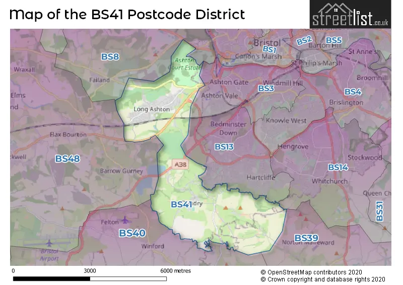
The BS41 Postcode shares a border with BS13 (BRISTOL, Bishopsworth), BS14 (BRISTOL, Whitchurch), BS40 (Wrington, Langford, Winford), BS48 (Nailsea, Backwell, Wraxall) and BS8 (BRISTOL, Clifton, Failand).
The primary settlement in the BS41 postcode district is Dundry, located in the county of Somerset in England. The most significant post town in this district is Bristol. Additionally, the settlement of Long Ashton is also significant in this postcode district.
For the district BS41, we have data on 2 postcode sectors. Here's a breakdown: The sector BS41 8, covers Dundry in Somerset. The sector BS41 9, covers Long Ashton in Somerset.

Map of the BS41 Postcode District
Explore the BS41 postcode district by using our free interactive map.
When it comes to local government, postal geography often disregards political borders. However, for a breakdown in the BS41 District: the district mostly encompasses the North Somerset (190 postcodes), and finally, the Bath and North East Somerset area (6 postcodes).
Weather Forecast for BS41
Press Button to Show Forecast for Bishopsworth
| Time Period | Icon | Description | Temperature | Rain Probability | Wind |
|---|---|---|---|---|---|
| 18:00 to 21:00 | Cloudy | 11.0°C (feels like 9.0°C) | 4.00% | WNW 7 mph | |
| 21:00 to 00:00 | Cloudy | 9.0°C (feels like 8.0°C) | 5.00% | SW 4 mph |
Press Button to Show Forecast for Bishopsworth
| Time Period | Icon | Description | Temperature | Rain Probability | Wind |
|---|---|---|---|---|---|
| 00:00 to 03:00 | Cloudy | 7.0°C (feels like 5.0°C) | 4.00% | WSW 7 mph | |
| 03:00 to 06:00 | Clear night | 5.0°C (feels like 3.0°C) | 1.00% | WNW 4 mph | |
| 06:00 to 09:00 | Cloudy | 6.0°C (feels like 5.0°C) | 5.00% | WSW 4 mph | |
| 09:00 to 12:00 | Light rain shower (day) | 9.0°C (feels like 7.0°C) | 30.00% | W 9 mph | |
| 12:00 to 15:00 | Cloudy | 12.0°C (feels like 10.0°C) | 12.00% | WNW 9 mph | |
| 15:00 to 18:00 | Cloudy | 12.0°C (feels like 10.0°C) | 5.00% | W 9 mph | |
| 18:00 to 21:00 | Cloudy | 11.0°C (feels like 9.0°C) | 8.00% | NNW 7 mph | |
| 21:00 to 00:00 | Cloudy | 9.0°C (feels like 7.0°C) | 4.00% | NE 7 mph |
Press Button to Show Forecast for Bishopsworth
| Time Period | Icon | Description | Temperature | Rain Probability | Wind |
|---|---|---|---|---|---|
| 00:00 to 03:00 | Cloudy | 7.0°C (feels like 6.0°C) | 5.00% | NE 4 mph | |
| 03:00 to 06:00 | Overcast | 6.0°C (feels like 5.0°C) | 8.00% | ENE 4 mph | |
| 06:00 to 09:00 | Cloudy | 6.0°C (feels like 4.0°C) | 8.00% | ENE 7 mph | |
| 09:00 to 12:00 | Cloudy | 8.0°C (feels like 6.0°C) | 11.00% | E 9 mph | |
| 12:00 to 15:00 | Overcast | 10.0°C (feels like 8.0°C) | 15.00% | E 9 mph | |
| 15:00 to 18:00 | Overcast | 10.0°C (feels like 8.0°C) | 19.00% | E 9 mph | |
| 18:00 to 21:00 | Overcast | 10.0°C (feels like 8.0°C) | 19.00% | ENE 7 mph | |
| 21:00 to 00:00 | Cloudy | 8.0°C (feels like 6.0°C) | 16.00% | E 7 mph |
Press Button to Show Forecast for Bishopsworth
| Time Period | Icon | Description | Temperature | Rain Probability | Wind |
|---|---|---|---|---|---|
| 00:00 to 03:00 | Cloudy | 7.0°C (feels like 5.0°C) | 14.00% | E 7 mph | |
| 03:00 to 06:00 | Cloudy | 6.0°C (feels like 4.0°C) | 17.00% | ENE 9 mph | |
| 06:00 to 09:00 | Cloudy | 6.0°C (feels like 3.0°C) | 18.00% | ENE 9 mph | |
| 09:00 to 12:00 | Light rain | 7.0°C (feels like 5.0°C) | 50.00% | ENE 11 mph | |
| 12:00 to 15:00 | Overcast | 10.0°C (feels like 7.0°C) | 21.00% | ENE 11 mph | |
| 15:00 to 18:00 | Cloudy | 11.0°C (feels like 9.0°C) | 19.00% | ENE 11 mph | |
| 18:00 to 21:00 | Light rain | 10.0°C (feels like 8.0°C) | 48.00% | NE 9 mph | |
| 21:00 to 00:00 | Light rain | 9.0°C (feels like 6.0°C) | 50.00% | NE 11 mph |
Press Button to Show Forecast for Bishopsworth
| Time Period | Icon | Description | Temperature | Rain Probability | Wind |
|---|---|---|---|---|---|
| 00:00 to 03:00 | Light rain | 8.0°C (feels like 5.0°C) | 51.00% | NE 9 mph | |
| 03:00 to 06:00 | Light rain | 7.0°C (feels like 5.0°C) | 52.00% | NE 9 mph | |
| 06:00 to 09:00 | Light rain | 7.0°C (feels like 5.0°C) | 52.00% | NE 9 mph | |
| 09:00 to 12:00 | Light rain | 9.0°C (feels like 7.0°C) | 50.00% | NE 9 mph | |
| 12:00 to 15:00 | Heavy rain shower (day) | 11.0°C (feels like 9.0°C) | 60.00% | NW 11 mph | |
| 15:00 to 18:00 | Heavy rain shower (day) | 12.0°C (feels like 9.0°C) | 58.00% | NNW 11 mph | |
| 18:00 to 21:00 | Light rain shower (day) | 11.0°C (feels like 9.0°C) | 36.00% | NNW 9 mph | |
| 21:00 to 00:00 | Clear night | 9.0°C (feels like 8.0°C) | 7.00% | NW 7 mph |
Where is the BS41 Postcode District?
The postcode district for BS41 is located in the town of Bristol. It is situated nearby towns such as Clevedon to the West, Winscombe to the Southwest, Bath to the East, Radstock to the Southeast, and Caldicot to the North. Additionally, the distance to London from this district is approximately 108.6 miles.
The district is within the post town of BRISTOL.
The sector has postcodes within the nation of England.
The BS41 Postcode District is covers the following regions.
- Bath and North East Somerset, North Somerset and South Gloucestershire - Gloucestershire, Wiltshire and Bath/Bristol area - South West (England)
- Bristol, City of - Gloucestershire, Wiltshire and Bath/Bristol area - South West (England)
| Postcode Sector | Delivery Office |
|---|---|
| BS41 8 | Bristol South Delivery Office |
| BS41 9 | Long Ashton Wayside Office |
| B | S | 4 | 1 | - | X | X | X |
| B | S | 4 | 1 | Space | Numeric | Letter | Letter |
Current Monthly Rental Prices
| # Bedrooms | Min Price | Max Price | Avg Price |
|---|---|---|---|
| 1 | £2,100 | £2,100 | £2,100 |
| 3 | £1,800 | £1,800 | £1,800 |
| 4 | £2,750 | £3,000 | £2,875 |
| 5 | £2,300 | £2,300 | £2,300 |
Current House Prices
| # Bedrooms | Min Price | Max Price | Avg Price |
|---|---|---|---|
| £1,500,000 | £1,500,000 | £1,500,000 | |
| 3 | £800,000 | £800,000 | £800,000 |
| 4 | £625,000 | £1,250,000 | £822,778 |
| 5 | £675,000 | £2,750,000 | £1,256,250 |
| 6 | £857,500 | £2,350,000 | £1,263,125 |
| 7 | £1,950,000 | £1,950,000 | £1,950,000 |
| 8 | £975,000 | £975,000 | £975,000 |
Estate Agents who Operate in the BS41 District
| Logo | Name | Brand Name | Address | Contact Number | Total Properties |
|---|---|---|---|---|---|
 | Bristol | Alexander May | 50 Weston Road, Long Ashton, Bristol, BS41 9HH | 01275 409789 | 14 |
 | Long Ashton | Andrews Estate Agents | 65 Weston Road, Long Ashton, Bristol, BS41 9AB | 01275 409793 | 8 |
 | Southville | The Bristol Residential Letting Co | 222 North Street, Southville, Bristol, BS3 1JD | 0117 463 0422 | 3 |
 | Clifton | Lloyd Williams Search and Select Ltd | 69 Princess Victoria Street, Clifton, Bristol, BS8 4DD | 0117 463 4663 | 3 |
 | Clifton | Savills | 20 The Mall, Bristol, BS8 4DR | 0117 463 4258 | 3 |
| Type of Property | 2018 Average | 2018 Sales | 2017 Average | 2017 Sales | 2016 Average | 2016 Sales | 2015 Average | 2015 Sales |
|---|---|---|---|---|---|---|---|---|
| Detached | £573,735 | 23 | £622,646 | 39 | £545,618 | 41 | £473,247 | 47 |
| Semi-Detached | £438,991 | 38 | £423,766 | 29 | £366,573 | 33 | £343,650 | 33 |
| Terraced | £315,874 | 19 | £329,035 | 24 | £321,953 | 35 | £313,842 | 19 |
| Flats | £196,475 | 10 | £162,629 | 7 | £152,938 | 8 | £155,181 | 16 |