The BS5 6 postcode sector is within the county of Bristol.
Did you know? According to the 2021 Census, the BS5 6 postcode sector is home to a bustling 13,917 residents!
Given that each sector allows for 400 unique postcode combinations. Letters C, I, K, M, O and V are not allowed in the last two letters of a postcode. With 248 postcodes already in use, this leaves 152 units available.
The largest settlement in the BS5 6 postal code is BRISTOL followed by Eastville, and Easton.
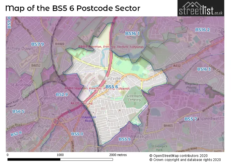
The BS5 6 Postcode shares a border with BS5 9 (BRISTOL, Redfield, Barton Hill), BS7 9 (BRISTOL, Bishopston, Horfield), BS2 9 (BRISTOL, St. Pauls, St. Agnes), BS5 0 (BRISTOL, Easton, Lawrence Hill), BS5 7 (BRISTOL, St. George, Speedwell), BS16 1 (BRISTOL, Stapleton, Hambrook), BS16 2 (BRISTOL, Fishponds, Frenchay) and BS16 3 (BRISTOL, Fishponds).
The sector is within the post town of BRISTOL.
BS5 6 is a postcode sector within the BS5 postcode district which is within the BS Bristol postcode area.
The Royal Mail delivery office for the BS5 6 postal sector is the Bristol East Delivery Office.
The area of the BS5 6 postcode sector is 0.81 square miles which is 2.10 square kilometres or 518.67 square acres.
The BS5 6 postcode sector is crossed by the M32 motorway.
Waterways within the BS5 6 postcode sector include the River Frome, Coombe Brook.

Map of the BS5 6 Postcode Sector
Explore the BS5 6 postcode sector by using our free interactive map.
| B | S | 5 | - | 6 | X | X |
| B | S | 5 | Space | 6 | Letter | Letter |
Official List of Streets
BRISTOL (100 Streets)
Eastville (19 Streets)
Easton (12 Streets)
Unofficial Streets or Alternative Spellings
BRISTOL
BANNERMAN ROAD BELL HILL CLAY BOTTOM CO-OPERATION ROAD MARLBOROUGH AVENUE ROSE GREEN ROAD STOTTBURY ROADWhitehall
GORDON ROAD BELLEVUE ROAD BERKELEY STREET BOSWELL COURT BRISTOL & BATH RAILWAY PATH EASTVILLE ROUNDABOUT FROME LANE GAS ALLEY PARK COURT SAINT LEONARDS ROAD SAINT MARKS AVENUE SAINT MARKS ROAD SANDY LANE SHAW ROADWeather Forecast for BS5 6
Press Button to Show Forecast for Eastville
| Time Period | Icon | Description | Temperature | Rain Probability | Wind |
|---|---|---|---|---|---|
| 03:00 to 06:00 | Cloudy | 7.0°C (feels like 6.0°C) | 4.00% | NNW 4 mph | |
| 06:00 to 09:00 | Overcast | 8.0°C (feels like 7.0°C) | 7.00% | NW 2 mph | |
| 09:00 to 12:00 | Cloudy | 9.0°C (feels like 8.0°C) | 4.00% | N 4 mph | |
| 12:00 to 15:00 | Cloudy | 12.0°C (feels like 10.0°C) | 4.00% | N 7 mph | |
| 15:00 to 18:00 | Sunny day | 13.0°C (feels like 12.0°C) | 2.00% | NNW 7 mph | |
| 18:00 to 21:00 | Sunny day | 12.0°C (feels like 10.0°C) | 0.00% | NNW 7 mph | |
| 21:00 to 00:00 | Clear night | 9.0°C (feels like 8.0°C) | 1.00% | E 4 mph |
Press Button to Show Forecast for Eastville
| Time Period | Icon | Description | Temperature | Rain Probability | Wind |
|---|---|---|---|---|---|
| 00:00 to 03:00 | Clear night | 6.0°C (feels like 5.0°C) | 1.00% | ESE 4 mph | |
| 03:00 to 06:00 | Clear night | 5.0°C (feels like 3.0°C) | 1.00% | NW 4 mph | |
| 06:00 to 09:00 | Cloudy | 5.0°C (feels like 4.0°C) | 5.00% | W 4 mph | |
| 09:00 to 12:00 | Cloudy | 9.0°C (feels like 8.0°C) | 5.00% | W 7 mph | |
| 12:00 to 15:00 | Overcast | 11.0°C (feels like 9.0°C) | 9.00% | W 9 mph | |
| 15:00 to 18:00 | Cloudy | 12.0°C (feels like 10.0°C) | 11.00% | W 9 mph | |
| 18:00 to 21:00 | Cloudy | 11.0°C (feels like 10.0°C) | 10.00% | NW 7 mph | |
| 21:00 to 00:00 | Cloudy | 9.0°C (feels like 8.0°C) | 7.00% | WNW 4 mph |
Press Button to Show Forecast for Eastville
| Time Period | Icon | Description | Temperature | Rain Probability | Wind |
|---|---|---|---|---|---|
| 00:00 to 03:00 | Overcast | 8.0°C (feels like 7.0°C) | 12.00% | ENE 4 mph | |
| 03:00 to 06:00 | Cloudy | 7.0°C (feels like 5.0°C) | 10.00% | ESE 4 mph | |
| 06:00 to 09:00 | Cloudy | 6.0°C (feels like 4.0°C) | 15.00% | ESE 7 mph | |
| 09:00 to 12:00 | Cloudy | 9.0°C (feels like 7.0°C) | 15.00% | SSE 7 mph | |
| 12:00 to 15:00 | Overcast | 11.0°C (feels like 9.0°C) | 20.00% | SSE 9 mph | |
| 15:00 to 18:00 | Overcast | 11.0°C (feels like 10.0°C) | 23.00% | SSE 7 mph | |
| 18:00 to 21:00 | Cloudy | 11.0°C (feels like 9.0°C) | 23.00% | SE 7 mph | |
| 21:00 to 00:00 | Cloudy | 9.0°C (feels like 7.0°C) | 18.00% | ESE 7 mph |
Press Button to Show Forecast for Eastville
| Time Period | Icon | Description | Temperature | Rain Probability | Wind |
|---|---|---|---|---|---|
| 00:00 to 03:00 | Overcast | 8.0°C (feels like 6.0°C) | 20.00% | ESE 7 mph | |
| 03:00 to 06:00 | Cloudy | 7.0°C (feels like 5.0°C) | 18.00% | E 7 mph | |
| 06:00 to 09:00 | Cloudy | 7.0°C (feels like 5.0°C) | 16.00% | NE 7 mph | |
| 09:00 to 12:00 | Cloudy | 10.0°C (feels like 8.0°C) | 14.00% | ENE 9 mph | |
| 12:00 to 15:00 | Cloudy | 12.0°C (feels like 10.0°C) | 18.00% | E 9 mph | |
| 15:00 to 18:00 | Light rain | 12.0°C (feels like 10.0°C) | 50.00% | ENE 9 mph | |
| 18:00 to 21:00 | Light rain shower (day) | 11.0°C (feels like 10.0°C) | 35.00% | NNE 9 mph | |
| 21:00 to 00:00 | Light rain shower (night) | 10.0°C (feels like 8.0°C) | 39.00% | ENE 7 mph |
Schools and Places of Education Within the BS5 6 Postcode Sector
Glenfrome Primary School
Community school
Cottisford Road, Bristol, , BS5 6TY
Head: Mrs Inger O'Callaghan
Ofsted Rating: Good
Inspection: 2021-07-14 (1015 days ago)
Website: Visit Glenfrome Primary School Website
Phone: 01173772247
Number of Pupils: 414
May Park Primary School
Academy sponsor led
Coombe Road, Bristol, , BS5 6LE
Head: Mrs Gina De N'Yeurt
Ofsted Rating: Requires improvement
Inspection: 2023-11-09 (167 days ago)
Website: Visit May Park Primary School Website
Phone: 01179030075
Number of Pupils: 524
House Prices in the BS5 6 Postcode Sector
| Type of Property | 2018 Average | 2018 Sales | 2017 Average | 2017 Sales | 2016 Average | 2016 Sales | 2015 Average | 2015 Sales |
|---|---|---|---|---|---|---|---|---|
| Detached | £176,000 | 1 | £415,250 | 2 | £0 | 0 | £171,000 | 1 |
| Semi-Detached | £275,430 | 25 | £295,700 | 15 | £257,186 | 18 | £226,578 | 18 |
| Terraced | £284,099 | 149 | £273,517 | 170 | £241,456 | 156 | £217,057 | 177 |
| Flats | £169,875 | 28 | £151,490 | 52 | £136,516 | 36 | £118,819 | 36 |
Important Postcodes BS5 6 in the Postcode Sector
BS5 6LE is the postcode for Orchard, May Park Primary School, Coombe Road, Arboretum, May Park Primary School, Coombe Road, May Park Primary School, Coombe Road, and PHASE 2A, May Park Primary School, Coombe Road
BS5 6NR is the postcode for Easton Job Centre, 442-450 Stapleton Road
BS5 6SA is the postcode for EAST TREES HEALTH CENTRE, 100A FISHPONDS ROAD, EASTVILLE, and East Trees Health Centre, 100a Fishponds Road
BS5 6TY is the postcode for Glenfrome Primary School, Cottisford Road, Eastville, and Glenfrome Primary School, Cottisford Road
BS5 6XX is the postcode for United Communities Eden House, Unit 10 Eastgate Retail Park, Eastgate Road, Brighter Places, Unit 10 Eastgate Retail Park, Eastgate Road, and Unit 10 Eastgate Retail Park, Eastgate Road
BS5 6YA is the postcode for Eastville Health Centre, East Park
| The BS5 6 Sector is within these Local Authorities |
|
|---|---|
| The BS5 6 Sector is within these Counties |
|
| The BS5 6 Sector is within these Water Company Areas |
|