This section of the site is all about the CA Postcode area, also known as the Carlisle Postal Area. Explore links to the next level to learn more about specific postcode districts such as CA1.
The CA postcode area represents a group of postal districts in the Carlisle area of the United Kingdom. The area code CA stands for the letters c and a in CAlisle. CA has a population of 318,244 and covers an area of 5,102,999 hectares. Fun fact: 0.49% of the population of Great Britain lives in this area.
The postcode area falls within the following counties: Cumbria (98.54%), Dumfries (0.78%), Northumberland (0.68%).
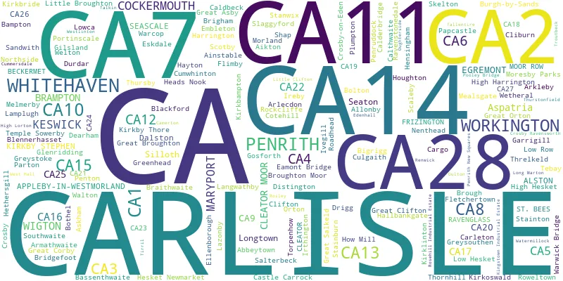
Post Towns and Postcode Districts for the CA Postcode
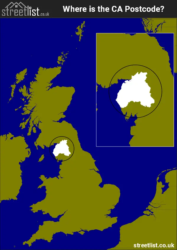
Where is the CA Postcode Area?
The CA Carlisle Postcode is in the North West of England. The postal area borders the following neighbouring postal areas: TD - Teviotdale, LA - Lancaster, NE - Newcastle upon Tyne, DL - Darlington and DG - Dumfries and Galloway, It also borders The Irish Sea and The Solway Firth.
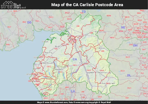
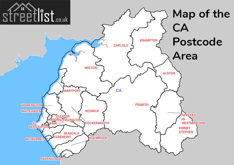
Map of the CA Carlisle Postcode Area
Explore the CA Carlisle postcode area by using our interactive map.
Postcode Districts within the CA Carlisle Postcode Area
There are 28 postcode districts within the Carlisle postcode area
A map showing the boundary of in relation to other areas
There are 16 towns within the Carlisle postcode area.
| Unit | Area² |
|---|---|
| Hectares | 5,102,999² |
| Miles | 19,703² |
| Feet | 549,281,709,361² |
| Kilometres | 51,030² |
Postal Delivery Offices serving the CA Carlisle Postcode Area
- Alston Scale Payment Delivery Office
- Appleby-in-westmorland Scale Payment Delivery Office
- Armathwaite Scale Payment Delivery Office
- Brampton Delivery Office
- Carlisle Delivery Office
- Cockermouth Delivery Office
- Egremont Delivery Office
- Keswick Delivery Office
- Kirkby Stephen Scale Payment Delivery Office
- Longtown (ca) Scale Payment Delivery Office
- Maryport Delivery Office
- Penrith Delivery Office
- Roweltown Scale Payment Delivery Office
- Seascale Scale Payment Delivery Office
- Shap Scale Payment Delivery Office
- Silloth Scale Payment Delivery Office
- Tebay Scale Payment Delivery Office
- Whitehaven Delivery Office
- Wigton Delivery Office
- Workington Delivery Office
Councils with Postcodes in CA
Towns and Villages within the CA Carlisle Postcode Area
- Abbeytown - village
- Aglionby - village
- Aikton - village
- Ainstable - village
- Allerby - village
- Allonby - village
- Alston - town
- Angerton - village
- Anthorn - village
- Appleby-in-Westmorland - town
- Applethwaite - village
- Arkleby - otherSettlement
- Arlecdon - village
- Armathwaite - village
- Asby - village
- Askham - village
- Aspatria - town
- Baggrow - village
- Bampton - village
- Bampton Grange - village
- Bassenthwaite - village
- Beaumont - village
- Beck - village
- Beckermet - village
- Bigrigg - village
- Blackford - village
- Blackwell - village
- Blencogo - village
- Blennerhasset - village
- Blindcrake - village
- Bolton - village
- Bolton Low Houses - village
- Bolton New Houses - otherSettlement
- Bothel - village
- Bowness-on-Solway - village
- Braithwaite - village
- Brampton - village
- Brampton - town
- Branthwaite - village
- Braystones - village
- Bridekirk - village
- Bridgefoot - village
- Brigham - village
- Broadwath - village
- Brockleymoor - village
- Brough - village
- Brougham - village
- Broughton Moor - village
- Buckabank - village
- Burgh by Sands - village
- Burrells - village
- Caldbeck - village
- Calder Bridge - village
- Calthwaite - village
- Camerton - village
- Cargo - village
- Carleton - village
- Carlisle - city
- Castle Carrock - village
- Catterlen - village
- Cleator - village
- Cleator Moor - town
- Cliburn - village
- Clifton - village
- Clifton Dykes - otherSettlement
- Cockermouth - town
- Common End - village
- Cotehill - village
- Croglin - village
- Crosby - village
- Crosby Ravensworth - village
- Crosby Villa - village
- Crosby-on-Eden - village
- Culgaith - village
- Cummersdale - village
- Cumwhinton - village
- Cumwhitton - village
- Dacre - village
- Dalston - village
- Dean - village
- Deanscales - village
- Dearham - village
- Drigg - village
- Dufton - village
- Durdar - village
- Eaglesfield - village
- Eamont Bridge - village
- East Causewayhead - otherSettlement
- Edenhall - village
- Egremont - town
- Embleton - village
- Ennerdale Bridge - village
- Eskdale Green - village
- Faugh - village
- Fletchertown - village
- Flimby - village
- Fothergill - village
- Frizington - village
- Galemire - village
- Gamblesby - village
- Garrigill - village
- Gilcrux - village
- Gilgarran - village
- Gilsland - village
- Glasson - village
- Glassonby - village
- Glenridding - village
- Gosforth - village
- Grayson Green - village
- Great Asby - village
- Great Broughton - village
- Great Clifton - village
- Great Corby - village
- Great Ormside - village
- Great Orton - village
- Great Salkeld - village
- Great Strickland - village
- Greenhead - village
- Greysouthen - village
- Greystoke - village
- Haile - village
- Hallbankgate - village
- Halton Lea Gate - village
- Harker - village
- Hartley - village
- Hawksdale - village
- Hayton - village
- Hayton - village
- Heads Nook - village
- Hesket Newmarket - village
- Hethersgill - village
- High Harrington - village
- High Hesket - village
- High Lorton - village
- Holmrook - village
- Houghton - village
- How - village
- Hunsonby - village
- Ireby - village
- Irthington - village
- Ivegill - village
- Keekle - village
- Keswick - town
- King's Meaburn - village
- Kirkbampton - village
- Kirkbride - village
- Kirkby Stephen - town
- Kirkby Thore - village
- Kirkhouse - village
- Kirkland - village
- Kirkoswald - village
- Knock - village
- Langrigg - village
- Langwathby - village
- Laversdale - village
- Lazonby - village
- Linstock - village
- Little Broughton - village
- Little Clifton - village
- Long Marton - village
- Longtown - town
- Low Hesket - village
- Low Lorton - village
- Low Moresby - village
- Low Row - village
- Lowca - village
- Lowther - village
- Maryport - town
- Maulds Meaburn - village
- Mawbray - village
- Mealsgate - village
- Melmerby - village
- Milburn - village
- Millbeck - village
- Monkhill - village
- Moor Row - village
- Moorhouse - village
- Moresby Parks - village
- Morland - village
- Motherby - village
- Nateby - village
- Nenthead - village
- Nethertown - village
- Newbiggin - village
- Newbiggin - village
- Newbiggin-on-Lune - village
- Newby East - village
- Newton Arlosh - village
- Newton Reigny - village
- Newtown - village
- Orton - village
- Oughterside - village
- Oulton - village
- Ousby - village
- Papcastle - village
- Parsonby - village
- Parton - village
- Patterdale - village
- Penrith - town
- Penruddock - village
- Pica - village
- Plumbland - village
- Plumpton - village
- Pooley Bridge - village
- Port Carlisle - village
- Portinscale - village
- Prospect - village
- Ravenglass - village
- Ravenstonedale - village
- Renwick - village
- Roadhead - village
- Rockcliffe - village
- Rosthwaite - village
- Rowrah - village
- Sandwith - village
- Santon - otherSettlement
- Scaleby - village
- Scotby - village
- Seascale - village
- Seaton - village
- Sebergham - village
- Sellafield - Settlement
- Shap - village
- Siddick - village
- Silloth - town
- Skelton - village
- Skinburness - village
- Skirsgill - otherSettlement
- Skirwith - village
- Smithfield - village
- Sockbridge - village
- Soulby - village
- Southwaite - village
- St Bees - village
- Stainburn - village
- Stainton - village
- Talkin - village
- Tallentire - village
- Tebay - village
- Temple Sowerby - village
- Thornby - otherSettlement
- Thornhill - village
- Thornthwaite - village
- Threlkeld - village
- Thursby - village
- Thurstonfield - village
- Tirril - village
- Torpenhow - village
- Uldale - village
- Walton - village
- Warcop - village
- Warwick Bridge - village
- Warwick-on-Eden - village
- Waverton - village
- Westlinton - village
- Westnewton - village
- Wetheral - village
- Whitehaven - town
- Wigton - town
- Winder - village
- Winscales - village
- Winton - village
- Woodend - village
- Woodville - village
- Workington - town
- Wreay - village
- Yanwath - village