The CA13 9 postcode sector is within the county of Cumbria.
Did you know? According to the 2021 Census, the CA13 9 postcode sector is home to a bustling 6,182 residents!
Given that each sector allows for 400 unique postcode combinations. Letters C, I, K, M, O and V are not allowed in the last two letters of a postcode. With 279 postcodes already in use, this leaves 121 units available.
The largest settlement in the CA13 9 postal code is COCKERMOUTH followed by Embleton, and High Lorton.
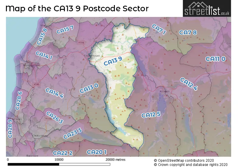
The CA13 9 Postcode shares a border with CA7 1 (Ireby, Mealsgate, Fletchertown), CA7 2 (Aspatria, Bothel, Gilcrux), CA12 4 (KESWICK, Threlkeld, Bassenthwaite), CA12 5 (KESWICK, Braithwaite, Portinscale), CA13 0 (COCKERMOUTH, Great Broughton, Brigham), CA20 1 (SEASCALE, Gosforth, Calderbridge) and CA23 3 (CLEATOR, Ennerdale, Kinniside).
The sector is within the post town of COCKERMOUTH.
CA13 9 is a postcode sector within the CA13 postcode district which is within the CA Carlisle postcode area.
The Royal Mail delivery office for the CA13 9 postal sector is the Cockermouth Delivery Office.
The area of the CA13 9 postcode sector is 52.66 square miles which is 136.39 square kilometres or 33,703.43 square acres.
The CA13 9 postcode sector is crossed by the A66 Major A road.
Waterways within the CA13 9 postcode sector include the River Derwent, River Cocker, Scale Beck, Far Ruddy Beck, Gates?arthdale Beck, Sourmill Gill, Gasgale Gill, Sail Beck.

Map of the CA13 9 Postcode Sector
Explore the CA13 9 postcode sector by using our free interactive map.
| C | A | 1 | 3 | - | 9 | X | X |
| C | A | 1 | 3 | Space | 9 | Letter | Letter |
Official List of Streets
COCKERMOUTH (135 Streets)
Lorton (1 Streets)
High Lorton (3 Streets)
Embleton (1 Streets)
Low Lorton (1 Streets)
Unofficial Streets or Alternative Spellings
COCKERMOUTH
CROWN STREET SULLART STREETWeather Forecast for CA13 9
Press Button to Show Forecast for Grisedale Pike
| Time Period | Icon | Description | Temperature | Rain Probability | Wind |
|---|---|---|---|---|---|
| 21:00 to 00:00 | Clear night | 0.0°C (feels like -5.0°C) | 1.00% | E 11 mph |
Press Button to Show Forecast for Grisedale Pike
| Time Period | Icon | Description | Temperature | Rain Probability | Wind |
|---|---|---|---|---|---|
| 00:00 to 03:00 | Partly cloudy (night) | -1.0°C (feels like -6.0°C) | 1.00% | ENE 11 mph | |
| 03:00 to 06:00 | Clear night | -2.0°C (feels like -7.0°C) | 4.00% | ENE 11 mph | |
| 06:00 to 09:00 | Partly cloudy (day) | -2.0°C (feels like -7.0°C) | 5.00% | NE 9 mph | |
| 09:00 to 12:00 | Overcast | 0.0°C (feels like -3.0°C) | 9.00% | ENE 7 mph | |
| 12:00 to 15:00 | Overcast | 2.0°C (feels like -1.0°C) | 9.00% | ENE 7 mph | |
| 15:00 to 18:00 | Cloudy | 2.0°C (feels like -1.0°C) | 8.00% | ENE 7 mph | |
| 18:00 to 21:00 | Overcast | 1.0°C (feels like -2.0°C) | 13.00% | ENE 7 mph | |
| 21:00 to 00:00 | Partly cloudy (night) | -1.0°C (feels like -5.0°C) | 5.00% | ENE 9 mph |
Press Button to Show Forecast for Grisedale Pike
| Time Period | Icon | Description | Temperature | Rain Probability | Wind |
|---|---|---|---|---|---|
| 00:00 to 03:00 | Partly cloudy (night) | -2.0°C (feels like -7.0°C) | 3.00% | E 11 mph | |
| 03:00 to 06:00 | Partly cloudy (night) | -2.0°C (feels like -7.0°C) | 3.00% | ENE 9 mph | |
| 06:00 to 09:00 | Partly cloudy (day) | -1.0°C (feels like -6.0°C) | 5.00% | ENE 11 mph | |
| 09:00 to 12:00 | Partly cloudy (day) | 1.0°C (feels like -3.0°C) | 6.00% | E 9 mph | |
| 12:00 to 15:00 | Overcast | 3.0°C (feels like -1.0°C) | 14.00% | E 11 mph | |
| 15:00 to 18:00 | Overcast | 4.0°C (feels like 0.0°C) | 13.00% | E 11 mph | |
| 18:00 to 21:00 | Cloudy | 3.0°C (feels like -2.0°C) | 10.00% | ENE 13 mph | |
| 21:00 to 00:00 | Cloudy | 0.0°C (feels like -5.0°C) | 11.00% | ENE 16 mph |
Press Button to Show Forecast for Grisedale Pike
| Time Period | Icon | Description | Temperature | Rain Probability | Wind |
|---|---|---|---|---|---|
| 00:00 to 03:00 | Partly cloudy (night) | -1.0°C (feels like -6.0°C) | 11.00% | NE 16 mph | |
| 03:00 to 06:00 | Cloudy | -1.0°C (feels like -7.0°C) | 14.00% | NE 18 mph | |
| 06:00 to 09:00 | Cloudy | 0.0°C (feels like -6.0°C) | 15.00% | NE 20 mph | |
| 09:00 to 12:00 | Cloudy | 2.0°C (feels like -3.0°C) | 18.00% | NE 18 mph | |
| 12:00 to 15:00 | Cloudy | 4.0°C (feels like -1.0°C) | 17.00% | NNE 16 mph | |
| 15:00 to 18:00 | Light rain | 4.0°C (feels like 0.0°C) | 47.00% | N 16 mph | |
| 18:00 to 21:00 | Light rain shower (day) | 3.0°C (feels like -1.0°C) | 36.00% | NNW 16 mph | |
| 21:00 to 00:00 | Partly cloudy (night) | 1.0°C (feels like -4.0°C) | 12.00% | NW 18 mph |
Schools and Places of Education Within the CA13 9 Postcode Sector
All Saints' CofE School
Voluntary controlled school
Slatefell Drive, Cockermouth, Cumbria, CA13 9BH
Head: Mrs Nicola Smallwood
Ofsted Rating: Good
Inspection: 2018-10-18 (2016 days ago)
Website: Visit All Saints' CofE School Website
Phone: 01900823431
Number of Pupils: 203
Cockermouth School
Academy converter
Castlegate Drive, Cockermouth, Cumbria, CA13 9HF
Head: Mr Richard King
Ofsted Rating: Good
Inspection: 2018-05-22 (2165 days ago)
Website: Visit Cockermouth School Website
Phone: 01900898888
Number of Pupils: 1322
Lorton School
Academy converter
High Lorton, Cockermouth, Cumbria, CA13 9UL
Head: Mrs Joanne Laker
Ofsted Rating: Good
Inspection: 2020-02-04 (1542 days ago)
Website: Visit Lorton School Website
Phone: 0190085919
Number of Pupils: 48
House Prices in the CA13 9 Postcode Sector
| Type of Property | 2018 Average | 2018 Sales | 2017 Average | 2017 Sales | 2016 Average | 2016 Sales | 2015 Average | 2015 Sales |
|---|---|---|---|---|---|---|---|---|
| Detached | £323,743 | 56 | £326,357 | 43 | £288,199 | 36 | £274,007 | 32 |
| Semi-Detached | £193,539 | 53 | £198,981 | 39 | £208,556 | 27 | £194,447 | 31 |
| Terraced | £148,954 | 39 | £149,684 | 29 | £168,510 | 20 | £211,579 | 28 |
| Flats | £141,500 | 12 | £92,563 | 8 | £122,125 | 4 | £98,682 | 11 |
Important Postcodes CA13 9 in the Postcode Sector
CA13 9BH is the postcode for All Saints C of E Primary School, Slatefell Drive
CA13 9HF is the postcode for THE MODULAR BUILDING, Cockermouth School, Castlegate Drive, Cockermouth School, Castlegate Drive, and ECO CENTRE, Cockermouth School, Castlegate Drive
CA13 9HT is the postcode for Cumbria Teaching PCT, Cockermouth Cottage Hospital, ISEL WARD, Cockermouth Hospital, Isel Road, Cockermouth Hospital, Isel Road, Cockermouth Community Care Centre, Isel Road, and Cumbria Integrated Care NHS Foundation Trust, Isel Ward, Cockermouth Hospital
CA13 9JR is the postcode for Cockermouth Sports Centre, Castlegate Drive, and Cockermouth Leisure Centre, Castlegate Drive
CA13 9JS is the postcode for The Fletcher Christian Tavern, 55 Main Street
CA13 9PR is the postcode for Cumbria Fire & Rescue Service, Brigade Headquarters, Station Road
CA13 9PZ is the postcode for Faifield Office Accommodation, Station Road
| The CA13 9 Sector is within these Local Authorities |
|
|---|---|
| The CA13 9 Sector is within these Counties |
|
| The CA13 9 Sector is within these Water Company Areas |
|
Tourist Attractions within the CA13 9 Postcode Area
We found 2 visitor attractions within the CA13 postcode area
| Whinlatter Forest & Visitor Centre |
|---|
| Visitor Centres |
| Heritage / Visitor Centre |
| View Whinlatter Forest & Visitor Centre on Google Maps |
| Honister Slate Mine |
| Visitor Centres |
| Heritage / Visitor Centre |
| View Honister Slate Mine on Google Maps |