The CA22 postcode district is a postal district located in the CA Carlisle postcode area with a population of 8,710 residents according to the 2021 England and Wales Census.
The area of the CA22 postcode district is 21.94 square miles which is 56.82 square kilometres or 14,039.65 acres.
Currently, the CA22 district has about 268 postcode units spread across 1 geographic postcode sectors.
Given that each sector allows for 400 unique postcode combinations, the district has a capacity of 400 postcodes. With 268 postcodes already in use, this leaves 132 units available.
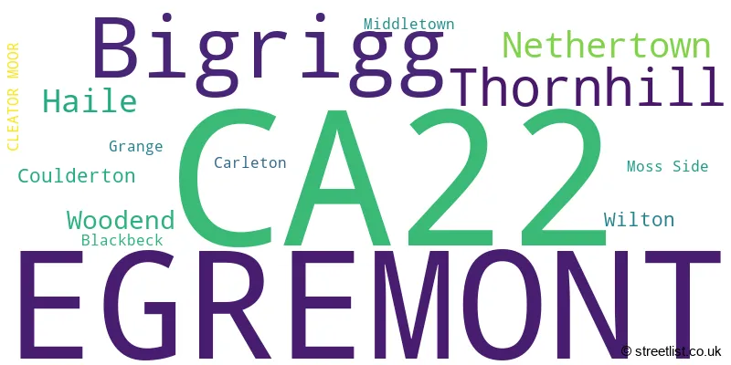
The largest settlement in the CA22 postal code is EGREMONT followed by Thornhill, and Bigrigg.
The postcode area has a boundary with The Irish Sea.
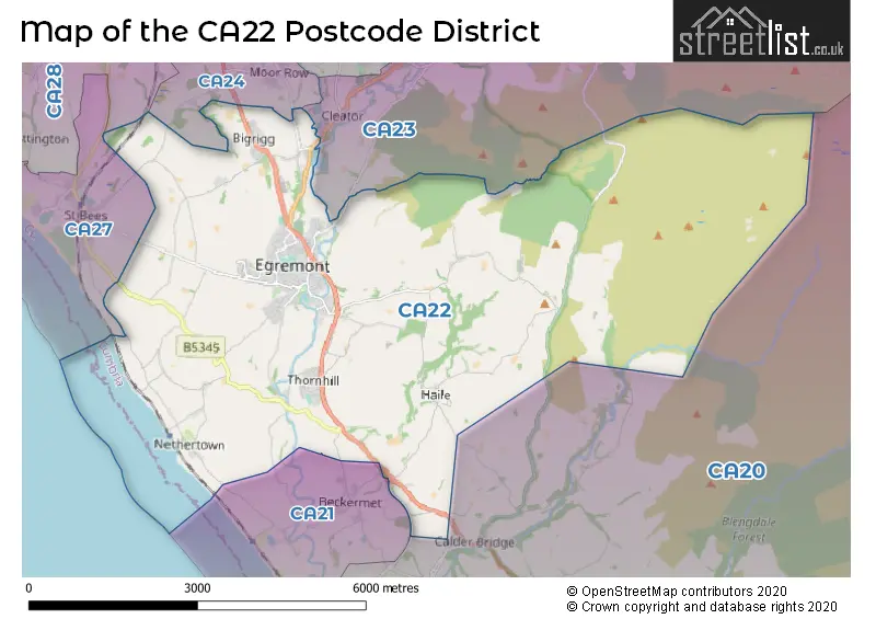
The CA22 Postcode shares a border with CA23 (CLEATOR, Ennerdale, Kinniside), CA24 (MOOR ROW, Westlakes Science & Technology Park, Linethwaite), CA28 (WHITEHAVEN, Hensingham, Moresby Parks), CA21 (BECKERMET, Braystones) and CA20 (SEASCALE, Gosforth, Calderbridge).
The CA22 postcode district in Cumbria, England, is primarily represented by the settlement of Egremont. Other significant settlements in the area include Bigrigg, Haile, Thornhill, and Nethertown.
For the district CA22, we have data on 2 postcode sectors. Here's a breakdown: The sector CA22 2, covers Egremont in Cumbria. The sector CA22 9 is non-geographic. It's often designated for PO Boxes, large organisations, or special services.
CA22 Postcode Sectors

Map of the CA22 Postcode District
Explore the CA22 postcode district by using our free interactive map.
When it comes to local government, postal geography often disregards political borders. However, for a breakdown in the CA22 District: the district mostly encompasses the Cumberland area with a total of 272 postcodes.
Weather Forecast for CA22
Press Button to Show Forecast for Egremont
| Time Period | Icon | Description | Temperature | Rain Probability | Wind |
|---|---|---|---|---|---|
| 15:00 to 18:00 | Sunny day | 9.0°C (feels like 6.0°C) | 0.00% | WNW 11 mph | |
| 18:00 to 21:00 | Partly cloudy (day) | 8.0°C (feels like 5.0°C) | 1.00% | W 11 mph | |
| 21:00 to 00:00 | Partly cloudy (night) | 7.0°C (feels like 4.0°C) | 1.00% | WNW 9 mph |
Press Button to Show Forecast for Egremont
| Time Period | Icon | Description | Temperature | Rain Probability | Wind |
|---|---|---|---|---|---|
| 00:00 to 03:00 | Cloudy | 6.0°C (feels like 4.0°C) | 3.00% | NW 9 mph | |
| 03:00 to 06:00 | Partly cloudy (night) | 6.0°C (feels like 3.0°C) | 0.00% | NW 9 mph | |
| 06:00 to 09:00 | Sunny day | 5.0°C (feels like 3.0°C) | 1.00% | N 7 mph | |
| 09:00 to 12:00 | Partly cloudy (day) | 8.0°C (feels like 5.0°C) | 4.00% | NNE 11 mph | |
| 12:00 to 15:00 | Cloudy | 9.0°C (feels like 7.0°C) | 5.00% | N 9 mph | |
| 15:00 to 18:00 | Cloudy | 9.0°C (feels like 7.0°C) | 7.00% | NNW 9 mph | |
| 18:00 to 21:00 | Cloudy | 8.0°C (feels like 6.0°C) | 7.00% | N 9 mph | |
| 21:00 to 00:00 | Cloudy | 6.0°C (feels like 3.0°C) | 4.00% | ENE 7 mph |
Press Button to Show Forecast for Egremont
| Time Period | Icon | Description | Temperature | Rain Probability | Wind |
|---|---|---|---|---|---|
| 00:00 to 03:00 | Partly cloudy (night) | 4.0°C (feels like 2.0°C) | 1.00% | ENE 7 mph | |
| 03:00 to 06:00 | Partly cloudy (night) | 3.0°C (feels like 1.0°C) | 1.00% | ENE 4 mph | |
| 06:00 to 09:00 | Partly cloudy (day) | 4.0°C (feels like 2.0°C) | 2.00% | NE 4 mph | |
| 09:00 to 12:00 | Partly cloudy (day) | 7.0°C (feels like 5.0°C) | 3.00% | NE 7 mph | |
| 12:00 to 15:00 | Overcast | 8.0°C (feels like 7.0°C) | 12.00% | N 4 mph | |
| 15:00 to 18:00 | Cloudy | 9.0°C (feels like 7.0°C) | 9.00% | NW 7 mph | |
| 18:00 to 21:00 | Cloudy | 8.0°C (feels like 6.0°C) | 8.00% | N 7 mph | |
| 21:00 to 00:00 | Partly cloudy (night) | 6.0°C (feels like 5.0°C) | 1.00% | NE 4 mph |
Press Button to Show Forecast for Egremont
| Time Period | Icon | Description | Temperature | Rain Probability | Wind |
|---|---|---|---|---|---|
| 00:00 to 03:00 | Partly cloudy (night) | 4.0°C (feels like 2.0°C) | 1.00% | ENE 7 mph | |
| 03:00 to 06:00 | Partly cloudy (night) | 4.0°C (feels like 2.0°C) | 2.00% | ENE 4 mph | |
| 06:00 to 09:00 | Partly cloudy (day) | 5.0°C (feels like 4.0°C) | 2.00% | NE 4 mph | |
| 09:00 to 12:00 | Partly cloudy (day) | 8.0°C (feels like 7.0°C) | 5.00% | ENE 7 mph | |
| 12:00 to 15:00 | Overcast | 10.0°C (feels like 8.0°C) | 14.00% | NE 7 mph | |
| 15:00 to 18:00 | Cloudy | 10.0°C (feels like 8.0°C) | 11.00% | NE 7 mph | |
| 18:00 to 21:00 | Cloudy | 10.0°C (feels like 8.0°C) | 9.00% | N 7 mph | |
| 21:00 to 00:00 | Partly cloudy (night) | 7.0°C (feels like 5.0°C) | 6.00% | NE 9 mph |
Press Button to Show Forecast for Egremont
| Time Period | Icon | Description | Temperature | Rain Probability | Wind |
|---|---|---|---|---|---|
| 00:00 to 03:00 | Cloudy | 6.0°C (feels like 3.0°C) | 11.00% | NNE 9 mph | |
| 03:00 to 06:00 | Partly cloudy (night) | 5.0°C (feels like 2.0°C) | 13.00% | NE 9 mph | |
| 06:00 to 09:00 | Partly cloudy (day) | 6.0°C (feels like 3.0°C) | 13.00% | NNE 11 mph | |
| 09:00 to 12:00 | Cloudy | 9.0°C (feels like 6.0°C) | 18.00% | NNE 11 mph | |
| 12:00 to 15:00 | Cloudy | 10.0°C (feels like 8.0°C) | 15.00% | NNE 11 mph | |
| 15:00 to 18:00 | Cloudy | 11.0°C (feels like 9.0°C) | 15.00% | N 11 mph | |
| 18:00 to 21:00 | Sunny day | 10.0°C (feels like 8.0°C) | 12.00% | N 11 mph | |
| 21:00 to 00:00 | Clear night | 8.0°C (feels like 6.0°C) | 8.00% | NNW 11 mph |
Where is the CA22 Postcode District?
The postcode district for CA22 is located in Egremont, a town in the district. It is nearby several other towns, including Cleator to the north, Beckermat to the south, Moor Row to the northwest, St. Bees to the west, and Holmrook to the southeast. Additionally, the distance from Egremont to the centre of London is approximately 248.9429275707474 miles.
The district covers the post towns of CLEATOR MOOR, EGREMONT.
The sector has postcodes within the nation of England.
The CA22 Postcode District is in the West Cumbria region of Cumbria within the North West (England).
Postcode Sectors within the CA22 District
| Postcode Sector | Delivery Office |
|---|---|
| CA22 2 | Egremont Delivery Office |
| C | A | 2 | 2 | - | X | X | X |
| C | A | 2 | 2 | Space | Numeric | Letter | Letter |
Current Monthly Rental Prices
| # Bedrooms | Min Price | Max Price | Avg Price |
|---|---|---|---|
| 3 | £700 | £1,200 | £950 |
Current House Prices
| # Bedrooms | Min Price | Max Price | Avg Price |
|---|---|---|---|
| £550,000 | £550,000 | £550,000 | |
| 2 | £119,950 | £200,000 | £151,989 |
| 3 | £120,000 | £425,000 | £219,328 |
| 4 | £285,000 | £600,000 | £397,488 |
| 5 | £374,995 | £562,500 | £471,861 |
| 6 | £550,000 | £550,000 | £550,000 |
| 7 | £410,000 | £410,000 | £410,000 |
Estate Agents who Operate in the CA22 District
| Logo | Name | Brand Name | Address | Contact Number | Total Properties |
|---|---|---|---|---|---|
 | Lillyhall | First Choice Move | Gate House, Hallwood Road, Lillyhall, Workington, CA14 4JR | 01946 552543 | 11 |
 | Whitehaven | Lillingtons Estate Agents | 58 Lowther Street, Whitehaven, CA28 7DP | 01946 590412 | 8 |
 | Whitehaven | Your Move | 67 Lowther Street, Whitehaven, CA28 7AH | 01946 550437 | 4 |
 | Cockermouth | Mitchells Land & Property | Lakeland Agricultural Centre, Cockermouth, CA13 0QQ | 01900 512349 | 2 |
 | Tyne, Tees & Border | Strike | Nationwide | 0191 625 0239 | 2 |
| Type of Property | 2018 Average | 2018 Sales | 2017 Average | 2017 Sales | 2016 Average | 2016 Sales | 2015 Average | 2015 Sales |
|---|---|---|---|---|---|---|---|---|
| Detached | £196,043 | 34 | £229,608 | 26 | £210,500 | 25 | £226,810 | 29 |
| Semi-Detached | £117,429 | 42 | £106,031 | 30 | £108,843 | 40 | £107,630 | 41 |
| Terraced | £91,953 | 45 | £89,069 | 52 | £82,209 | 49 | £88,915 | 58 |
| Flats | £70,167 | 3 | £60,290 | 5 | £57,750 | 8 | £58,999 | 5 |