The CA4 postcode district is a postal district located in the CA Carlisle postcode area with a population of 9,702 residents according to the 2021 England and Wales Census.
The area of the CA4 postcode district is 86.30 square miles which is 223.51 square kilometres or 55,231.34 acres.
Currently, the CA4 district has about 466 postcode units spread across 3 geographic postcode sectors.
Given that each sector allows for 400 unique postcode combinations, the district has a capacity of 1,200 postcodes. With 466 postcodes already in use, this leaves 734 units available.
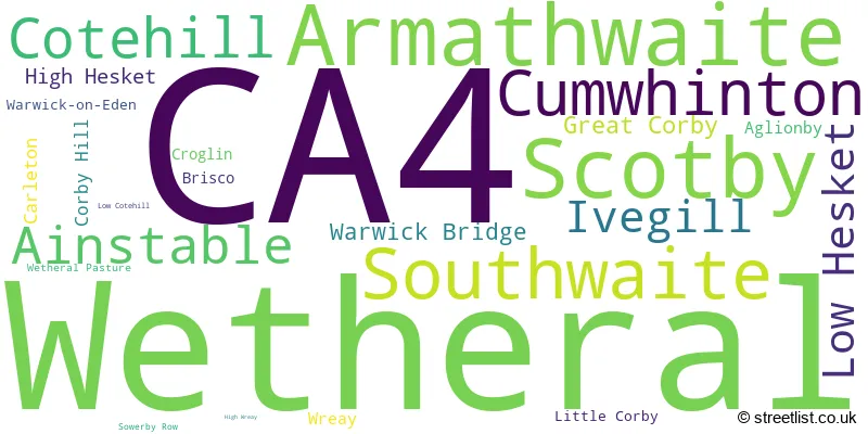
The largest settlement in the CA4 postal code is Scotby followed by Wetheral, and Armathwaite.
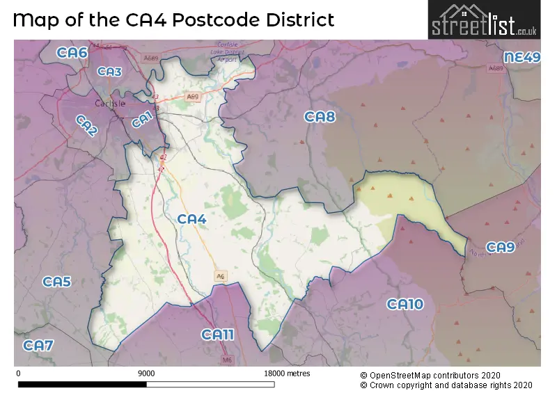
The CA4 Postcode shares a border with CA10 (Shap, Whinfell, Lazonby), CA8 (BRAMPTON, Heads Nook, Gilsland), CA6 (Longtown, Irthington, Kirklinton), CA5 (Dalston, Burgh-by-Sands, Thursby), CA1 (CARLISLE, Rosehill Industrial Estate), CA2 (CARLISLE, Belle Vue), CA3 (CARLISLE, Houghton, Stanwix) and CA11 (PENRITH, Stainton, Greystoke).
The primary settlement in the CA4 postcode district is Southwaite, located in the county of Cumbria in England. Other significant settlements in this district include Cumwhinton, Ivegill, and Wreay. The main post town in this postcode district is Carlisle.
For the district CA4, we have data on 3 postcode sectors. Here's a breakdown: The sector CA4 0, covers Southwaite and Cotehill and Ivegill and Low Hesket in Cumbria. The sector CA4 8, covers Wetheral and Scotby in Cumbria. The sector CA4 9, covers Armathwaite and Ainstable and Croglin in Cumbria.

Map of the CA4 Postcode District
Explore the CA4 postcode district by using our free interactive map.
When it comes to local government, postal geography often disregards political borders. However, for a breakdown in the CA4 District: the district mostly encompasses the Cumberland (304 postcodes), and finally, the Westmorland and Furness area (170 postcodes).
Weather Forecast for CA4
Press Button to Show Forecast for Wreay
| Time Period | Icon | Description | Temperature | Rain Probability | Wind |
|---|---|---|---|---|---|
| 15:00 to 18:00 | Cloudy | 9.0°C (feels like 7.0°C) | 5.00% | N 9 mph | |
| 18:00 to 21:00 | Cloudy | 8.0°C (feels like 6.0°C) | 6.00% | NE 7 mph | |
| 21:00 to 00:00 | Partly cloudy (night) | 3.0°C (feels like 1.0°C) | 1.00% | E 4 mph |
Press Button to Show Forecast for Wreay
| Time Period | Icon | Description | Temperature | Rain Probability | Wind |
|---|---|---|---|---|---|
| 00:00 to 03:00 | Partly cloudy (night) | 0.0°C (feels like -2.0°C) | 1.00% | ENE 2 mph | |
| 03:00 to 06:00 | Partly cloudy (night) | 0.0°C (feels like -2.0°C) | 1.00% | E 2 mph | |
| 06:00 to 09:00 | Partly cloudy (day) | 2.0°C (feels like 1.0°C) | 2.00% | N 2 mph | |
| 09:00 to 12:00 | Cloudy | 7.0°C (feels like 5.0°C) | 6.00% | ENE 4 mph | |
| 12:00 to 15:00 | Cloudy | 8.0°C (feels like 8.0°C) | 10.00% | ENE 4 mph | |
| 15:00 to 18:00 | Cloudy | 9.0°C (feels like 8.0°C) | 12.00% | NE 4 mph | |
| 18:00 to 21:00 | Cloudy | 8.0°C (feels like 6.0°C) | 9.00% | ENE 4 mph | |
| 21:00 to 00:00 | Cloudy | 4.0°C (feels like 3.0°C) | 6.00% | ENE 4 mph |
Press Button to Show Forecast for Wreay
| Time Period | Icon | Description | Temperature | Rain Probability | Wind |
|---|---|---|---|---|---|
| 00:00 to 03:00 | Partly cloudy (night) | 2.0°C (feels like 0.0°C) | 2.00% | E 4 mph | |
| 03:00 to 06:00 | Clear night | 1.0°C (feels like -1.0°C) | 3.00% | E 4 mph | |
| 06:00 to 09:00 | Partly cloudy (day) | 3.0°C (feels like 1.0°C) | 4.00% | E 4 mph | |
| 09:00 to 12:00 | Partly cloudy (day) | 8.0°C (feels like 6.0°C) | 7.00% | E 4 mph | |
| 12:00 to 15:00 | Cloudy | 9.0°C (feels like 8.0°C) | 13.00% | ESE 7 mph | |
| 15:00 to 18:00 | Cloudy | 10.0°C (feels like 8.0°C) | 15.00% | E 7 mph | |
| 18:00 to 21:00 | Cloudy | 9.0°C (feels like 7.0°C) | 9.00% | ENE 7 mph | |
| 21:00 to 00:00 | Partly cloudy (night) | 5.0°C (feels like 3.0°C) | 5.00% | ENE 7 mph |
Press Button to Show Forecast for Wreay
| Time Period | Icon | Description | Temperature | Rain Probability | Wind |
|---|---|---|---|---|---|
| 00:00 to 03:00 | Cloudy | 3.0°C (feels like 1.0°C) | 9.00% | NE 4 mph | |
| 03:00 to 06:00 | Cloudy | 3.0°C (feels like 1.0°C) | 12.00% | NE 7 mph | |
| 06:00 to 09:00 | Cloudy | 5.0°C (feels like 3.0°C) | 14.00% | NNE 7 mph | |
| 09:00 to 12:00 | Light rain | 9.0°C (feels like 6.0°C) | 43.00% | NE 9 mph | |
| 12:00 to 15:00 | Cloudy | 10.0°C (feels like 9.0°C) | 15.00% | NE 9 mph | |
| 15:00 to 18:00 | Cloudy | 11.0°C (feels like 9.0°C) | 18.00% | NNE 9 mph | |
| 18:00 to 21:00 | Cloudy | 10.0°C (feels like 8.0°C) | 17.00% | NNE 7 mph | |
| 21:00 to 00:00 | Partly cloudy (night) | 7.0°C (feels like 5.0°C) | 11.00% | WNW 7 mph |
Where is the CA4 Postcode District?
The data shows that the postcode district for CA4 is in Carlisle. Carlisle is situated in the north-west region of the United Kingdom. Nearby towns to Carlisle include Penrith to the south, Brampton to the north-east, Alston to the east, Wigton to the west, Gretna to the north-west, Canonbie to the north, and Keswick to the south-west. Furthermore, the distance from Carlisle to London is approximately 254.67 miles.
The district is within the post town of CARLISLE.
The sector has postcodes within the nation of England.
The CA4 Postcode District is in the East Cumbria region of Cumbria within the North West (England).
| Postcode Sector | Delivery Office |
|---|---|
| CA4 0 | Carlisle Delivery Office |
| CA4 0 | Armathwaite Scale Payment Delivery Office |
| CA4 8 | Carlisle Delivery Office |
| CA4 9 | Carlisle Delivery Office |
| CA4 9 | Armathwaite Scale Payment Delivery Office |
| C | A | 4 | - | X | X | X |
| C | A | 4 | Space | Numeric | Letter | Letter |
Current Monthly Rental Prices
| # Bedrooms | Min Price | Max Price | Avg Price |
|---|---|---|---|
| 2 | £695 | £1,000 | £830 |
Current House Prices
| # Bedrooms | Min Price | Max Price | Avg Price |
|---|---|---|---|
| £1,025,000 | £1,025,000 | £1,025,000 | |
| 3 | £550,000 | £800,000 | £648,333 |
| 4 | £500,000 | £900,000 | £678,438 |
| 5 | £630,000 | £1,250,000 | £856,000 |
Estate Agents who Operate in the CA4 District
| Logo | Name | Brand Name | Address | Contact Number | Total Properties |
|---|---|---|---|---|---|
 | Penrith | David Britton Estates | 15, Old London Road Penrith Cumbria CA11 8JJ | 01768 800886 | 10 |
 | North West | eXp UK | 1 Northumberland Avenue, Trafalgar Square, London, WC2N 5BW | 03304 609968 | 9 |
 | Carlisle | Cumbrian Properties | 2 Lonsdale Street, Carlisle, CA1 1DB | 01228 276406 | 8 |
 | Carlisle | Hayward Tod Associates | 7 Paternoster Row, Carlisle, CA3 8TT | 01228 810300 | 6 |
 | Carlisle | Fine & Country | Fine & Country- North Cumbria and South Scotland 50 Warwick Road Carlisle CA1 1DN | 01228 276951 | 6 |
| Type of Property | 2018 Average | 2018 Sales | 2017 Average | 2017 Sales | 2016 Average | 2016 Sales | 2015 Average | 2015 Sales |
|---|---|---|---|---|---|---|---|---|
| Detached | £324,223 | 100 | £293,731 | 90 | £310,074 | 83 | £304,943 | 74 |
| Semi-Detached | £199,513 | 62 | £203,567 | 60 | £184,342 | 39 | £212,172 | 44 |
| Terraced | £155,012 | 21 | £167,879 | 21 | £153,580 | 22 | £154,650 | 28 |
| Flats | £176,411 | 18 | £156,196 | 12 | £115,446 | 12 | £149,070 | 15 |