The CB9 7 postcode sector lies where the three counties of Cambridgeshire, Essex, and Suffolk meet.
Did you know? According to the 2021 Census, the CB9 7 postcode sector is home to a bustling 10,288 residents!
Given that each sector allows for 400 unique postcode combinations. Letters C, I, K, M, O and V are not allowed in the last two letters of a postcode. With 300 postcodes already in use, this leaves 100 units available.
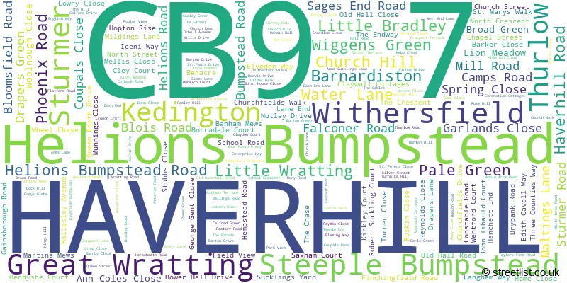
The largest settlement in the CB9 7 postal code is HAVERHILL followed by Kedington, and Steeple Bumpstead.
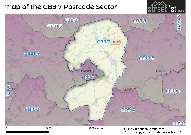
The CB9 7 Postcode shares a border with CB9 0 (HAVERHILL), CB9 9 (HAVERHILL), CB10 2 (SAFFRON WALDEN, Wimbish, Ashdon), CM7 4 (Great Bardfield, Wethersfield, Finchingfield), CO9 4 (Great Yeldham, Toppesfield, Ridgewell), CO10 8 (Clare, Hundon, Cavendish), CB8 9 (NEWMARKET, Cheveley, Dullingham), CB9 8 (HAVERHILL), CB21 4 (Linton, Balsham, Castle Camps) and CB21 5 (Fulbourn, Great Wilbraham, Weston Colville).
The sector is within the post town of HAVERHILL.
CB9 7 is a postcode sector within the CB9 postcode district which is within the CB Cambridge postcode area.
The Royal Mail delivery office for the CB9 7 postal sector is the Kedington Scale Payment Delivery Office and Haverhill Delivery Office.
The area of the CB9 7 postcode sector is 31.12 square miles which is 80.60 square kilometres or 19,917.56 square acres.
Waterways within the CB9 7 postcode sector include the River Stour.

Map of the CB9 7 Postcode Sector
Explore the CB9 7 postcode sector by using our free interactive map.
| C | B | 9 | - | 7 | X | X |
| C | B | 9 | Space | 7 | Letter | Letter |
Official List of Streets
Sturmer (16 Streets)
HAVERHILL (79 Streets)
Little Wratting (12 Streets)
Steeple Bumpstead (38 Streets)
Kedington (32 Streets)
Thurlow (11 Streets)
Withersfield (21 Streets)
Little Bradley (2 Streets)
Helions Bumpstead (11 Streets)
Barnardiston (6 Streets)
Great Wratting (5 Streets)
Unofficial Streets or Alternative Spellings
Great Wratting
CORONATION COTTAGESHAVERHILL
ASHLEA ROAD BERGAMOT ROAD BOYTON CLOSE EAST PARK CLOSE HALES BARN ROAD HAWTHORN ROAD MONARCH CLOSE PEARMAIN WALK TEASEL CLOSE WRATTING ROADCastle Camps
PARK LANENew England
STURMER ROADHempstead
BUMPSTEAD ROADGreat Bradley
THURLOW ROADWeather Forecast for CB9 7
Press Button to Show Forecast for Haverhill
| Time Period | Icon | Description | Temperature | Rain Probability | Wind |
|---|---|---|---|---|---|
| 12:00 to 15:00 | Cloudy | 9.0°C (feels like 6.0°C) | 45.00% | WNW 9 mph | |
| 15:00 to 18:00 | Light rain | 8.0°C (feels like 5.0°C) | 43.00% | NNW 9 mph | |
| 18:00 to 21:00 | Cloudy | 7.0°C (feels like 6.0°C) | 10.00% | NNE 4 mph | |
| 21:00 to 00:00 | Partly cloudy (night) | 4.0°C (feels like 2.0°C) | 1.00% | NE 4 mph |
Press Button to Show Forecast for Haverhill
| Time Period | Icon | Description | Temperature | Rain Probability | Wind |
|---|---|---|---|---|---|
| 00:00 to 03:00 | Partly cloudy (night) | 2.0°C (feels like 0.0°C) | 1.00% | NNE 4 mph | |
| 03:00 to 06:00 | Partly cloudy (night) | 1.0°C (feels like -1.0°C) | 1.00% | N 4 mph | |
| 06:00 to 09:00 | Partly cloudy (day) | 3.0°C (feels like 1.0°C) | 2.00% | NNE 4 mph | |
| 09:00 to 12:00 | Partly cloudy (day) | 8.0°C (feels like 6.0°C) | 2.00% | ENE 7 mph | |
| 12:00 to 15:00 | Overcast | 10.0°C (feels like 9.0°C) | 9.00% | ENE 4 mph | |
| 15:00 to 18:00 | Overcast | 10.0°C (feels like 9.0°C) | 11.00% | E 7 mph | |
| 18:00 to 21:00 | Cloudy | 8.0°C (feels like 6.0°C) | 10.00% | ESE 7 mph | |
| 21:00 to 00:00 | Cloudy | 6.0°C (feels like 4.0°C) | 9.00% | E 7 mph |
Press Button to Show Forecast for Haverhill
| Time Period | Icon | Description | Temperature | Rain Probability | Wind |
|---|---|---|---|---|---|
| 00:00 to 03:00 | Cloudy | 5.0°C (feels like 2.0°C) | 12.00% | ENE 7 mph | |
| 03:00 to 06:00 | Cloudy | 5.0°C (feels like 2.0°C) | 13.00% | ENE 7 mph | |
| 06:00 to 09:00 | Light rain | 6.0°C (feels like 3.0°C) | 46.00% | ENE 9 mph | |
| 09:00 to 12:00 | Overcast | 9.0°C (feels like 6.0°C) | 19.00% | ENE 11 mph | |
| 12:00 to 15:00 | Cloudy | 11.0°C (feels like 9.0°C) | 17.00% | E 11 mph | |
| 15:00 to 18:00 | Cloudy | 12.0°C (feels like 10.0°C) | 18.00% | E 11 mph | |
| 18:00 to 21:00 | Cloudy | 10.0°C (feels like 8.0°C) | 20.00% | ENE 11 mph | |
| 21:00 to 00:00 | Light rain | 9.0°C (feels like 6.0°C) | 46.00% | ENE 9 mph |
Press Button to Show Forecast for Haverhill
| Time Period | Icon | Description | Temperature | Rain Probability | Wind |
|---|---|---|---|---|---|
| 00:00 to 03:00 | Light rain | 9.0°C (feels like 6.0°C) | 48.00% | ENE 9 mph | |
| 03:00 to 06:00 | Cloudy | 9.0°C (feels like 6.0°C) | 24.00% | E 9 mph | |
| 06:00 to 09:00 | Light rain | 9.0°C (feels like 7.0°C) | 51.00% | E 9 mph | |
| 09:00 to 12:00 | Light rain | 11.0°C (feels like 8.0°C) | 55.00% | SSE 11 mph | |
| 12:00 to 15:00 | Heavy rain shower (day) | 12.0°C (feels like 10.0°C) | 58.00% | S 13 mph | |
| 15:00 to 18:00 | Heavy rain shower (day) | 13.0°C (feels like 10.0°C) | 57.00% | S 13 mph | |
| 18:00 to 21:00 | Light rain shower (day) | 12.0°C (feels like 10.0°C) | 35.00% | SSW 9 mph | |
| 21:00 to 00:00 | Partly cloudy (night) | 9.0°C (feels like 7.0°C) | 6.00% | S 9 mph |
Schools and Places of Education Within the CB9 7 Postcode Sector
Broadlands Hall
Other independent special school
, Haverhill, Suffolk, CB9 7UA
Head: Mr Humayun Ahmed
Ofsted Rating: Good
Inspection: 2021-12-02 (875 days ago)
Website: Visit Broadlands Hall Website
Phone: 01440702559
Number of Pupils: 24
Kedington Primary Academy
Academy converter
Church Walk, Haverhill, Suffolk, CB9 7QZ
Head: Mrs Vicky Doherty
Ofsted Rating: Good
Inspection: 2019-03-13 (1870 days ago)
Website: Visit Kedington Primary Academy Website
Phone: 01440702787
Number of Pupils: 211
Steeple Bumpstead Primary School
Academy sponsor led
Bower Hall Drive, Haverhill, Suffolk, CB9 7ED
Head: Mrs Vicky Doherty
Ofsted Rating: Good
Inspection: 2022-07-06 (659 days ago)
Website: Visit Steeple Bumpstead Primary School Website
Phone: 01440730220
Number of Pupils: 174
Thurlow Voluntary Controlled Primary School
Voluntary controlled school
The Street, Haverhill, Suffolk, CB9 7HY
Head: Mrs Sharon FitzGerald
Ofsted Rating: Good
Inspection: 2023-03-22 (400 days ago)
Website: Visit Thurlow Voluntary Controlled Primary School Website
Phone: 01440783281
Number of Pupils: 59
House Prices in the CB9 7 Postcode Sector
| Type of Property | 2018 Average | 2018 Sales | 2017 Average | 2017 Sales | 2016 Average | 2016 Sales | 2015 Average | 2015 Sales |
|---|---|---|---|---|---|---|---|---|
| Detached | £415,143 | 55 | £415,370 | 76 | £353,190 | 69 | £331,166 | 116 |
| Semi-Detached | £276,384 | 40 | £279,868 | 44 | £264,230 | 41 | £230,234 | 53 |
| Terraced | £220,602 | 46 | £232,116 | 74 | £212,514 | 83 | £207,937 | 84 |
| Flats | £162,650 | 3 | £169,563 | 8 | £147,220 | 12 | £133,666 | 9 |
Important Postcodes CB9 7 in the Postcode Sector
CB9 7ED is the postcode for Steeple Bumpstead Primary School, Bower Hall Drive, Steeple Bumpstead Primary School, Bower Hall Drive, Steeple Bumpstead, and MAIN BUILDING, Steeple Bumpstead Primary School, Bower Hall Drive
CB9 7HY is the postcode for Thurlow Primary School, Pound Green, and Thurlow Primary School, Pound Green, Thurlow
CB9 7QZ is the postcode for Kedington Primary Academy, Church Walk, Kedington Primary Academy, Church Walk, Kedington, and Kedington Primary School, Church Walk
CB9 7YD is the postcode for Parkway Middle School, Park Road, and Unity School Partnership Offices, Park Road
CB9 7YH is the postcode for 1a, Boundary Road, Sturmer
| The CB9 7 Sector is within these Local Authorities |
|
|---|---|
| The CB9 7 Sector is within these Counties |
|
| The CB9 7 Sector is within these Water Company Areas |
|