The CF14 postcode district is a postal district located in the CF Cardiff postcode area with a population of 78,050 residents according to the 2021 England and Wales Census.
The area of the CF14 postcode district is 12.86 square miles which is 33.32 square kilometres or 8,232.71 acres.
Currently, the CF14 district has about 1647 postcode units spread across 9 geographic postcode sectors.
Given that each sector allows for 400 unique postcode combinations, the district has a capacity of 3,600 postcodes. With 1647 postcodes already in use, this leaves 1953 units available.
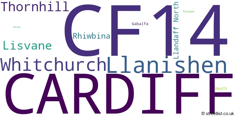
The largest settlement in the CF14 postal code is WHITCHURCH followed by CARDIFF, and GABALFA.
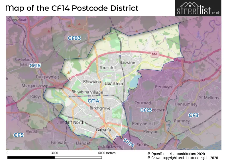
The CF14 Postcode shares a border with CF83 (CAERPHILLY, BEDWAS, LLANBRADACH), CF23 (PENYLAN, CARDIFF, LLANEDEYRN), CF5 (CARDIFF, CANTON, FAIRWATER), CF15 (RADYR, PENTYRCH, TONGWYNLAIS), CF24 (ROATH, CATHAYS, SPLOTT) and CF10 (BUTETOWN, CATHAYS, ADAMSDOWN).
The CF14 postcode district primarily consists of the settlement of Cardiff in the county of South Glamorgan. Other significant settlements include Lisvane, Llanishen, Whitchurch, Gabalfa, Maindy, Heath, Lisvane, Rhiwbina, Pantmawr, Thornhill.
For the district CF14, we have data on 10 postcode sectors. Here's a breakdown: The sector CF14 0, covers Lisvane and Cardiff in South Glamorgan. The sector CF14 1, covers Cardiff and Whitchurch in South Glamorgan. The sector CF14 2, covers Cardiff and Llandaff North and Whitchurch in South Glamorgan. The sector CF14 3, covers Cardiff in South Glamorgan. The sector CF14 4, covers Cardiff in South Glamorgan. The sector CF14 5, covers Llanishen in South Glamorgan. The sector CF14 6, covers Cardiff and Rhiwbina in South Glamorgan. The sector CF14 7, covers Cardiff and Whitchurch in South Glamorgan. The sector CF14 8 is non-geographic. It's often designated for PO Boxes, large organisations, or special services. The sector CF14 9, covers Thornhill in South Glamorgan.

Map of the CF14 Postcode District
Explore the CF14 postcode district by using our free interactive map.
When it comes to local government, postal geography often disregards political borders. However, for a breakdown in the CF14 District: the district mostly encompasses the Caerdydd - Cardiff area with a total of 1657 postcodes.
Weather Forecast for CF14
Press Button to Show Forecast for Llanishen
| Time Period | Icon | Description | Temperature | Rain Probability | Wind |
|---|---|---|---|---|---|
| 03:00 to 06:00 | Clear night | 4.0°C (feels like 2.0°C) | 0.00% | N 7 mph | |
| 06:00 to 09:00 | Sunny day | 4.0°C (feels like 1.0°C) | 0.00% | N 7 mph | |
| 09:00 to 12:00 | Sunny day | 8.0°C (feels like 7.0°C) | 0.00% | E 2 mph | |
| 12:00 to 15:00 | Partly cloudy (day) | 11.0°C (feels like 9.0°C) | 0.00% | SW 7 mph | |
| 15:00 to 18:00 | Cloudy | 10.0°C (feels like 8.0°C) | 6.00% | WSW 13 mph | |
| 18:00 to 21:00 | Cloudy | 10.0°C (feels like 7.0°C) | 5.00% | W 13 mph | |
| 21:00 to 00:00 | Cloudy | 9.0°C (feels like 7.0°C) | 6.00% | W 13 mph |
Press Button to Show Forecast for Llanishen
| Time Period | Icon | Description | Temperature | Rain Probability | Wind |
|---|---|---|---|---|---|
| 00:00 to 03:00 | Cloudy | 10.0°C (feels like 7.0°C) | 5.00% | W 13 mph | |
| 03:00 to 06:00 | Cloudy | 9.0°C (feels like 7.0°C) | 4.00% | WNW 11 mph | |
| 06:00 to 09:00 | Cloudy | 9.0°C (feels like 7.0°C) | 6.00% | WNW 11 mph | |
| 09:00 to 12:00 | Cloudy | 11.0°C (feels like 8.0°C) | 6.00% | NW 13 mph | |
| 12:00 to 15:00 | Cloudy | 12.0°C (feels like 9.0°C) | 5.00% | NW 16 mph | |
| 15:00 to 18:00 | Cloudy | 13.0°C (feels like 10.0°C) | 4.00% | NNW 13 mph | |
| 18:00 to 21:00 | Sunny day | 12.0°C (feels like 9.0°C) | 1.00% | NNW 11 mph | |
| 21:00 to 00:00 | Partly cloudy (night) | 9.0°C (feels like 7.0°C) | 1.00% | N 9 mph |
Press Button to Show Forecast for Llanishen
| Time Period | Icon | Description | Temperature | Rain Probability | Wind |
|---|---|---|---|---|---|
| 00:00 to 03:00 | Clear night | 7.0°C (feels like 5.0°C) | 0.00% | NNW 7 mph | |
| 03:00 to 06:00 | Clear night | 7.0°C (feels like 4.0°C) | 1.00% | N 7 mph | |
| 06:00 to 09:00 | Sunny day | 6.0°C (feels like 4.0°C) | 1.00% | NNE 7 mph | |
| 09:00 to 12:00 | Partly cloudy (day) | 9.0°C (feels like 7.0°C) | 1.00% | NE 7 mph | |
| 12:00 to 15:00 | Cloudy | 11.0°C (feels like 10.0°C) | 4.00% | NE 4 mph | |
| 15:00 to 18:00 | Sunny day | 12.0°C (feels like 11.0°C) | 2.00% | NE 7 mph | |
| 18:00 to 21:00 | Sunny day | 12.0°C (feels like 11.0°C) | 1.00% | WNW 7 mph | |
| 21:00 to 00:00 | Clear night | 10.0°C (feels like 8.0°C) | 1.00% | NNE 7 mph |
Press Button to Show Forecast for Llanishen
| Time Period | Icon | Description | Temperature | Rain Probability | Wind |
|---|---|---|---|---|---|
| 00:00 to 03:00 | Clear night | 8.0°C (feels like 7.0°C) | 0.00% | NE 4 mph | |
| 03:00 to 06:00 | Clear night | 7.0°C (feels like 5.0°C) | 0.00% | NE 4 mph | |
| 06:00 to 09:00 | Sunny day | 7.0°C (feels like 5.0°C) | 0.00% | NNE 4 mph | |
| 09:00 to 12:00 | Sunny day | 10.0°C (feels like 9.0°C) | 1.00% | NNE 4 mph | |
| 12:00 to 15:00 | Cloudy | 13.0°C (feels like 11.0°C) | 4.00% | E 7 mph | |
| 15:00 to 18:00 | Cloudy | 13.0°C (feels like 12.0°C) | 5.00% | NW 7 mph | |
| 18:00 to 21:00 | Cloudy | 13.0°C (feels like 12.0°C) | 4.00% | NNW 7 mph | |
| 21:00 to 00:00 | Clear night | 11.0°C (feels like 10.0°C) | 1.00% | ENE 7 mph |
Where is the CF14 Postcode District?
The postcode district CF14 is located in CARDIFF. It is in close proximity to several nearby towns. To the North West is CAERPHILLY which is approximately 3.57 miles away. To the South is DINAS POWYS, situated around 6.60 miles from CF14. Towards the West is PONTYCLUN, which is approximately 8.20 miles away. To the North is HENGOED, located around 8.90 miles from CF14. Towards the South West is BARRY, situated approximately 9.04 miles away. The nearest town in the East is NEWPORT, which is around 10.49 miles from CF14. Additionally, CF14 is approximately 132.21 miles from London.
The district is within the post town of CARDIFF.
The sector has postcodes within the nation of Wales.
The CF14 Postcode District is covers the following regions.
- Cardiff and Vale of Glamorgan - East Wales - Wales
- Gwent Valleys - West Wales - Wales
Postcode Sectors within the CF14 District
| Postcode Sector | Delivery Office |
|---|---|
| CF14 0 | Cardiff North Delivery Office |
| CF14 1 | Cardiff North Delivery Office |
| CF14 2 | Cardiff North Delivery Office |
| CF14 3 | Cardiff North Delivery Office |
| CF14 4 | Cardiff North Delivery Office |
| CF14 5 | Cardiff North Delivery Office |
| CF14 6 | Cardiff North Delivery Office |
| CF14 7 | Cardiff North Delivery Office |
| CF14 9 | Cardiff North Delivery Office |
| C | F | 1 | 4 | - | X | X | X |
| C | F | 1 | 4 | Space | Numeric | Letter | Letter |
Current Monthly Rental Prices
| # Bedrooms | Min Price | Max Price | Avg Price |
|---|---|---|---|
| 1 | £2,680 | £2,735 | £2,698 |
| 2 | £1,450 | £3,595 | £2,388 |
| 3 | £1,500 | £1,700 | £1,575 |
| 4 | £1,750 | £2,000 | £1,908 |
| 5 | £1,750 | £2,400 | £2,150 |
| 6 | £2,400 | £3,000 | £2,800 |
Current House Prices
| # Bedrooms | Min Price | Max Price | Avg Price |
|---|---|---|---|
| 3 | £285,000 | £400,000 | £336,667 |
| 4 | £480,000 | £1,200,000 | £952,083 |
| 5 | £895,000 | £1,550,000 | £1,261,667 |
| 6 | £949,950 | £1,300,000 | £1,179,990 |
| 7 | £1,250,000 | £1,250,000 | £1,250,000 |
Estate Agents who Operate in the CF14 District
| Logo | Name | Brand Name | Address | Contact Number | Total Properties |
|---|---|---|---|---|---|
 | Cardiff | Edwards & Co | 19 Heol Y Deri Rhiwbina Cardiff CF14 6HA | 029 2271 6448 | 43 |
 | Llanishen | Darlows | 19/19a Station Road, Llanishen, Cardiff, CF14 5LS | 029 2271 5335 | 37 |
 | Llanishen | Peter Alan | 24 Station Road, Llanishen, Cardiff, CF14 5LT | 029 2271 6635 | 31 |
 | Whitchurch | Peter Alan | 26 Merthyr Road, Whitchurch, Cardiff, CF14 1DH | 029 2271 7868 | 27 |
 | Whitchurch | Thomas H Wood | 14 Park Road Whitchurch Cardiff CF14 7BQ | 029 2271 2990 | 25 |
| Type of Property | 2018 Average | 2018 Sales | 2017 Average | 2017 Sales | 2016 Average | 2016 Sales | 2015 Average | 2015 Sales |
|---|---|---|---|---|---|---|---|---|
| Detached | £423,026 | 248 | £405,542 | 226 | £415,959 | 230 | £388,226 | 225 |
| Semi-Detached | £287,618 | 476 | £283,584 | 452 | £272,503 | 486 | £252,398 | 437 |
| Terraced | £228,256 | 338 | £223,908 | 365 | £209,884 | 383 | £195,829 | 379 |
| Flats | £154,918 | 252 | £139,565 | 236 | £128,708 | 257 | £124,702 | 222 |
Hotels within the Postcode Area
We found 14 hotels and guest houses within the CF14 postcode area