The CF15 9 postcode sector stands on the Mid Glamorgan and South Glamorgan border.
Did you know? According to the 2021 Census, the CF15 9 postcode sector is home to a bustling 5,977 residents!
Given that each sector allows for 400 unique postcode combinations. Letters C, I, K, M, O and V are not allowed in the last two letters of a postcode. With 156 postcodes already in use, this leaves 244 units available.
The largest settlement in the CF15 9 postal code is PENTYRCH followed by CREIGIAU, and Gwaelod-y-Garth.
The CF15 9 Postcode shares a border with CF5 6 (ST FAGANS, WENVOE, CREIGIAU), CF15 7 (TONGWYNLAIS, TAFF'S WELL, Taffs Well), CF15 8 (RADYR, MORGANSTOWN, GWAELOD-Y-GARTH), CF72 8 (LLANTRISANT, TALBOT GREEN, MISKIN), CF37 5 (RHYDYFELIN, PONTYPRIDD, TREFOREST INDUSTRIAL ESTATE) and CF38 1 (CHURCH VILLAGE, Tonteg, TON-TEG).
The sector is within the post town of CARDIFF.
CF15 9 is a postcode sector within the CF15 postcode district which is within the CF Cardiff postcode area.
The Royal Mail delivery office for the CF15 9 postal sector is the Cardiff North West Delivery Office.
The area of the CF15 9 postcode sector is 6.27 square miles which is 16.23 square kilometres or 4,011.31 square acres.

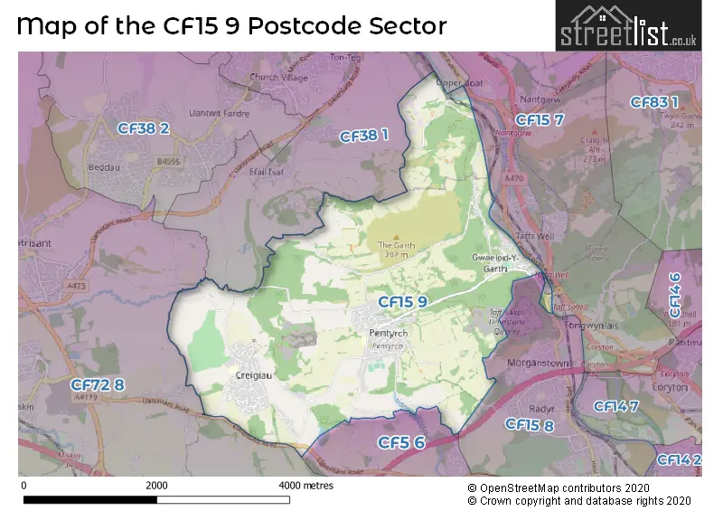
Map of the CF15 9 Postcode Sector
Explore the CF15 9 postcode sector by using our free interactive map.
| C | F | 1 | 5 | - | 9 | X | X |
| C | F | 1 | 5 | Space | 9 | Letter | Letter |
Official List of Streets
Gwaelod-y-Garth (24 Streets)
Pentyrch (41 Streets)
Creigiau (28 Streets)
Unofficial Streets or Alternative Spellings
Morganstown
TY NANT ROADRadyr
PANT TAWEL LANEPentyrch
AEL-Y-BRYN TYN-Y-COED ROADTreforest Industrial Estate
THE WILLOWFORDTonteg
WILLOWFORD ROADEfail Isaf
HEOL CREIGIAUCapel Llanilltern
LLANTRISANT ROAD STAR LANECreigiau
HEOL PANT-Y-GORED MAES-Y-DDERWEN MAES-Y-NANT MAES-Y-RHEDYN MAES-YR-ONNEN PARC CASTELL-Y-MYNACH PARC-Y-BRYN PARC-Y-COED PARC-Y-FELINGroesfaen
TYNANT ROADWeather Forecast for CF15 9
Press Button to Show Forecast for Llantrisant
| Time Period | Icon | Description | Temperature | Rain Probability | Wind |
|---|---|---|---|---|---|
| 00:00 to 03:00 | Cloudy | 7.0°C (feels like 5.0°C) | 5.00% | NNE 4 mph | |
| 03:00 to 06:00 | Cloudy | 6.0°C (feels like 4.0°C) | 5.00% | NE 7 mph | |
| 06:00 to 09:00 | Cloudy | 6.0°C (feels like 3.0°C) | 9.00% | ENE 9 mph | |
| 09:00 to 12:00 | Cloudy | 7.0°C (feels like 5.0°C) | 10.00% | E 9 mph | |
| 12:00 to 15:00 | Overcast | 9.0°C (feels like 7.0°C) | 15.00% | E 9 mph | |
| 15:00 to 18:00 | Overcast | 10.0°C (feels like 8.0°C) | 17.00% | E 9 mph | |
| 18:00 to 21:00 | Cloudy | 9.0°C (feels like 7.0°C) | 15.00% | E 9 mph | |
| 21:00 to 00:00 | Cloudy | 8.0°C (feels like 5.0°C) | 17.00% | ENE 9 mph |
Press Button to Show Forecast for Llantrisant
| Time Period | Icon | Description | Temperature | Rain Probability | Wind |
|---|---|---|---|---|---|
| 00:00 to 03:00 | Cloudy | 7.0°C (feels like 4.0°C) | 15.00% | ENE 9 mph | |
| 03:00 to 06:00 | Cloudy | 6.0°C (feels like 3.0°C) | 12.00% | ENE 11 mph | |
| 06:00 to 09:00 | Cloudy | 6.0°C (feels like 2.0°C) | 14.00% | NE 11 mph | |
| 09:00 to 12:00 | Cloudy | 7.0°C (feels like 4.0°C) | 20.00% | NE 13 mph | |
| 12:00 to 15:00 | Overcast | 9.0°C (feels like 6.0°C) | 20.00% | ENE 13 mph | |
| 15:00 to 18:00 | Cloudy | 10.0°C (feels like 7.0°C) | 15.00% | ENE 13 mph | |
| 18:00 to 21:00 | Cloudy | 10.0°C (feels like 7.0°C) | 15.00% | NE 11 mph | |
| 21:00 to 00:00 | Light rain | 9.0°C (feels like 6.0°C) | 49.00% | NE 13 mph |
Press Button to Show Forecast for Llantrisant
| Time Period | Icon | Description | Temperature | Rain Probability | Wind |
|---|---|---|---|---|---|
| 00:00 to 03:00 | Light rain | 8.0°C (feels like 5.0°C) | 46.00% | NE 13 mph | |
| 03:00 to 06:00 | Light rain | 7.0°C (feels like 4.0°C) | 52.00% | NE 13 mph | |
| 06:00 to 09:00 | Cloudy | 7.0°C (feels like 4.0°C) | 25.00% | NE 11 mph | |
| 09:00 to 12:00 | Light rain | 9.0°C (feels like 6.0°C) | 45.00% | NE 11 mph | |
| 12:00 to 15:00 | Heavy rain shower (day) | 10.0°C (feels like 8.0°C) | 56.00% | NW 11 mph | |
| 15:00 to 18:00 | Heavy rain shower (day) | 11.0°C (feels like 9.0°C) | 54.00% | NNW 11 mph | |
| 18:00 to 21:00 | Cloudy | 11.0°C (feels like 8.0°C) | 13.00% | NW 11 mph | |
| 21:00 to 00:00 | Clear night | 9.0°C (feels like 6.0°C) | 4.00% | NNE 9 mph |
House Prices in the CF15 9 Postcode Sector
| Type of Property | 2018 Average | 2018 Sales | 2017 Average | 2017 Sales | 2016 Average | 2016 Sales | 2015 Average | 2015 Sales |
|---|---|---|---|---|---|---|---|---|
| Detached | £413,089 | 41 | £415,846 | 68 | £346,966 | 65 | £368,463 | 44 |
| Semi-Detached | £237,889 | 23 | £207,385 | 34 | £255,886 | 18 | £254,056 | 18 |
| Terraced | £179,625 | 8 | £164,599 | 15 | £168,542 | 18 | £209,462 | 13 |
| Flats | £128,333 | 3 | £144,900 | 5 | £103,161 | 9 | £111,500 | 2 |
Important Postcodes CF15 9 in the Postcode Sector
CF15 9AA is the postcode for Royal Mail, Cardiff North West Delivery Office, Gwaelod y Garth Industrial Estate
CF15 9HJ is the postcode for Gwaelod y Garth Primary School, Main Road
CF15 9NN is the postcode for Creigiau Primary School, Tregarth Court, Creigiau, and Creigiau Primary School, Creigiau
CF15 9QL is the postcode for Pentyrch Primary School, Bronllwyn
| The CF15 9 Sector is within these Local Authorities |
|
|---|---|
| The CF15 9 Sector is within these Counties |
|
| The CF15 9 Sector is within these Water Company Areas |
|