The CF40 postcode district is a postal district located in the CF Cardiff postcode area with a population of 20,090 residents according to the 2021 England and Wales Census.
The area of the CF40 postcode district is 8.43 square miles which is 21.84 square kilometres or 5,396.57 acres.
Currently, the CF40 district has about 475 postcode units spread across 2 geographic postcode sectors.
Given that each sector allows for 400 unique postcode combinations, the district has a capacity of 800 postcodes. With 475 postcodes already in use, this leaves 325 units available.
The largest settlement in the CF40 postal code is TONYPANDY followed by TREALAW, and PEN-Y-GRAIG.
The CF40 Postcode shares a border with CF39 (TONYREFAIL, PORTH, YNYS-HIR), CF41 (PENTRE, YSTRAD, GELLI) and CF32 (TONDU, OGMORE VALE, SARN).
The primary settlement in the CF40 postcode district is Tonypandy, which is located in the county of Mid Glamorgan in Wales. Other significant settlements in the district include Penrhiwfer, Penygraig, and Williamstown. The most significant post town in the district is Tonypandy.
For the district CF40, we have data on 3 postcode sectors. Here's a breakdown: The sector CF40 1, covers Tonypandy in Mid Glamorgan. The sector CF40 2, covers Tonypandy in Mid Glamorgan. The sector CF40 9 is non-geographic. It's often designated for PO Boxes, large organisations, or special services.

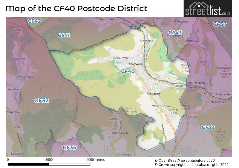
Map of the CF40 Postcode District
Explore the CF40 postcode district by using our free interactive map.
When it comes to local government, postal geography often disregards political borders. However, for a breakdown in the CF40 District: the district mostly encompasses the Rhondda Cynon Taf - Rhondda Cynon Taf area with a total of 476 postcodes.
Weather Forecast for CF40
Press Button to Show Forecast for Tonypandy
| Time Period | Icon | Description | Temperature | Rain Probability | Wind |
|---|---|---|---|---|---|
| 03:00 to 06:00 | Overcast | 8.0°C (feels like 6.0°C) | 11.00% | WNW 9 mph | |
| 06:00 to 09:00 | Cloudy | 9.0°C (feels like 6.0°C) | 7.00% | WNW 9 mph | |
| 09:00 to 12:00 | Overcast | 10.0°C (feels like 8.0°C) | 9.00% | NW 13 mph | |
| 12:00 to 15:00 | Overcast | 11.0°C (feels like 9.0°C) | 9.00% | NNW 13 mph | |
| 15:00 to 18:00 | Cloudy | 12.0°C (feels like 10.0°C) | 4.00% | NNW 13 mph | |
| 18:00 to 21:00 | Cloudy | 10.0°C (feels like 8.0°C) | 4.00% | NNW 11 mph | |
| 21:00 to 00:00 | Clear night | 7.0°C (feels like 6.0°C) | 1.00% | NNW 7 mph |
Press Button to Show Forecast for Tonypandy
| Time Period | Icon | Description | Temperature | Rain Probability | Wind |
|---|---|---|---|---|---|
| 00:00 to 03:00 | Clear night | 6.0°C (feels like 3.0°C) | 1.00% | NNW 7 mph | |
| 03:00 to 06:00 | Partly cloudy (night) | 5.0°C (feels like 3.0°C) | 1.00% | N 4 mph | |
| 06:00 to 09:00 | Partly cloudy (day) | 5.0°C (feels like 3.0°C) | 2.00% | NE 4 mph | |
| 09:00 to 12:00 | Partly cloudy (day) | 8.0°C (feels like 7.0°C) | 2.00% | ENE 4 mph | |
| 12:00 to 15:00 | Overcast | 11.0°C (feels like 10.0°C) | 8.00% | NE 4 mph | |
| 15:00 to 18:00 | Cloudy | 11.0°C (feels like 10.0°C) | 6.00% | WNW 4 mph | |
| 18:00 to 21:00 | Cloudy | 11.0°C (feels like 10.0°C) | 6.00% | WSW 4 mph | |
| 21:00 to 00:00 | Clear night | 8.0°C (feels like 7.0°C) | 2.00% | ENE 4 mph |
Press Button to Show Forecast for Tonypandy
| Time Period | Icon | Description | Temperature | Rain Probability | Wind |
|---|---|---|---|---|---|
| 00:00 to 03:00 | Clear night | 5.0°C (feels like 4.0°C) | 1.00% | NE 4 mph | |
| 03:00 to 06:00 | Clear night | 4.0°C (feels like 2.0°C) | 1.00% | NNE 4 mph | |
| 06:00 to 09:00 | Sunny day | 5.0°C (feels like 3.0°C) | 1.00% | NNE 4 mph | |
| 09:00 to 12:00 | Sunny day | 10.0°C (feels like 9.0°C) | 0.00% | NNE 4 mph | |
| 12:00 to 15:00 | Cloudy | 12.0°C (feels like 11.0°C) | 4.00% | NNE 7 mph | |
| 15:00 to 18:00 | Overcast | 13.0°C (feels like 12.0°C) | 9.00% | NNE 7 mph | |
| 18:00 to 21:00 | Cloudy | 11.0°C (feels like 10.0°C) | 6.00% | NNE 7 mph | |
| 21:00 to 00:00 | Partly cloudy (night) | 9.0°C (feels like 7.0°C) | 2.00% | NE 7 mph |
Press Button to Show Forecast for Tonypandy
| Time Period | Icon | Description | Temperature | Rain Probability | Wind |
|---|---|---|---|---|---|
| 00:00 to 03:00 | Partly cloudy (night) | 7.0°C (feels like 5.0°C) | 2.00% | NE 7 mph | |
| 03:00 to 06:00 | Partly cloudy (night) | 6.0°C (feels like 3.0°C) | 1.00% | NE 7 mph | |
| 06:00 to 09:00 | Sunny day | 6.0°C (feels like 4.0°C) | 1.00% | NE 7 mph | |
| 09:00 to 12:00 | Cloudy | 9.0°C (feels like 7.0°C) | 6.00% | NE 9 mph | |
| 12:00 to 15:00 | Cloudy | 11.0°C (feels like 9.0°C) | 9.00% | NE 9 mph | |
| 15:00 to 18:00 | Cloudy | 11.0°C (feels like 9.0°C) | 15.00% | NE 9 mph | |
| 18:00 to 21:00 | Cloudy | 10.0°C (feels like 8.0°C) | 15.00% | NE 9 mph | |
| 21:00 to 00:00 | Partly cloudy (night) | 8.0°C (feels like 6.0°C) | 10.00% | NE 7 mph |
Where is the CF40 Postcode District?
The data provided states that the CF40 postcode district is located in Tonypandy. Tonypandy is a town in the Rhondda Valley, and it is in close proximity to several nearby towns. To the north, there is Pentre, located approximately 2.12 miles away. To the east, there is Porth, situated at a distance of approximately 2.12 miles. Additionally, Treorchy is located to the northwest, around 3.99 miles away, and Mountain Ash is positioned to the northeast, approximately 5.72 miles away. Furthermore, the town of Pontyclun is situated to the southeast, approximately 7.37 miles away. In terms of its relationship to London, the CF40 postcode district is located around 143.80 miles from the center of London.
The district covers the post towns of PORTH, TONYPANDY.
The sector has postcodes within the nation of Wales.
The CF40 Postcode District is in the Central Valleys region of West Wales within the Wales.
| Postcode Sector | Delivery Office |
|---|---|
| CF40 1 | Mid Rhondda Ganol Delivery Office |
| CF40 2 | Mid Rhondda Ganol Delivery Office |
| C | F | 4 | 0 | - | X | X | X |
| C | F | 4 | 0 | Space | Numeric | Letter | Letter |
Current Monthly Rental Prices
| # Bedrooms | Min Price | Max Price | Avg Price |
|---|---|---|---|
| 1 | £650 | £650 | £650 |
| 2 | £600 | £650 | £625 |
| 3 | £675 | £800 | £738 |
Current House Prices
| # Bedrooms | Min Price | Max Price | Avg Price |
|---|---|---|---|
| £200,000 | £200,000 | £200,000 | |
| 2 | £169,995 | £189,950 | £179,973 |
| 3 | £169,995 | £475,000 | £229,274 |
| 4 | £200,000 | £389,999 | £286,661 |
| 6 | £425,000 | £425,000 | £425,000 |
Estate Agents who Operate in the CF40 District
| Logo | Name | Brand Name | Address | Contact Number | Total Properties |
|---|---|---|---|---|---|
 | Tonyrefail | Property Plus Estate Agents | 22 Mill Street Tonyrefail CF39 8AA | 01440 840589 | 32 |
 | Tonypandy | Osborne Estates | Unit 3, 97 Dunraven Street Tonypandy CF40 1AR | 01443 809433 | 25 |
 | covering Tonypandy | Darlows | covering Tonypandy | 01443 801714 | 14 |
 | Talbot Green | 3EA | 103 Talbot Road Talbot Green CF72 8AE | 01443 706401 | 6 |
 | Pontypridd | Peter Alan | 94 Taff Street, Pontypridd, CF37 4SL | 01443 801044 | 5 |
| Type of Property | 2018 Average | 2018 Sales | 2017 Average | 2017 Sales | 2016 Average | 2016 Sales | 2015 Average | 2015 Sales |
|---|---|---|---|---|---|---|---|---|
| Detached | £210,690 | 23 | £191,906 | 16 | £138,269 | 13 | £168,667 | 13 |
| Semi-Detached | £115,680 | 33 | £99,450 | 30 | £96,911 | 35 | £104,656 | 25 |
| Terraced | £71,489 | 283 | £69,885 | 248 | £64,410 | 229 | £62,855 | 212 |
| Flats | £59,296 | 3 | £0 | 0 | £34,500 | 3 | £35,250 | 3 |