The CH42 4 postcode sector is within the county of Merseyside.
Did you know? According to the 2021 Census, the CH42 4 postcode sector is home to a bustling 4,465 residents!
Given that each sector allows for 400 unique postcode combinations. Letters C, I, K, M, O and V are not allowed in the last two letters of a postcode. With 78 postcodes already in use, this leaves 322 units available.
The CH42 4 postal code covers the settlement of BIRKENHEAD.
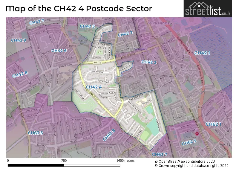
The CH42 4 Postcode shares a border with CH42 1 (BIRKENHEAD), CH42 3 (BIRKENHEAD), CH42 5 (BIRKENHEAD), CH42 6 (BIRKENHEAD), CH42 2 (BIRKENHEAD), CH62 5 (WIRRAL, New Ferry, Port Sunlight), CH63 5 (WIRRAL, Bebington, Higher Bebington), CH63 7 (WIRRAL, Bebington) and CH63 8 (WIRRAL, Bebington, Higher Bebington).
The sector is within the post town of BIRKENHEAD.
CH42 4 is a postcode sector within the CH42 postcode district which is within the CH Chester postcode area.
The Royal Mail delivery office for the CH42 4 postal sector is the Birkenhead Delivery Office.
The area of the CH42 4 postcode sector is 0.30 square miles which is 0.79 square kilometres or 195.09 square acres.

Map of the CH42 4 Postcode Sector
Explore the CH42 4 postcode sector by using our free interactive map.
| C | H | 4 | 2 | - | 4 | X | X |
| C | H | 4 | 2 | Space | 4 | Letter | Letter |
Official List of Streets
BIRKENHEAD (41 Streets)
Unofficial Streets or Alternative Spellings
Weather Forecast for CH42 4
Press Button to Show Forecast for Rock Ferry
| Time Period | Icon | Description | Temperature | Rain Probability | Wind |
|---|---|---|---|---|---|
| 06:00 to 09:00 | Partly cloudy (day) | 7.0°C (feels like 5.0°C) | 4.00% | NNE 7 mph | |
| 09:00 to 12:00 | Cloudy | 9.0°C (feels like 7.0°C) | 3.00% | N 7 mph | |
| 12:00 to 15:00 | Cloudy | 11.0°C (feels like 9.0°C) | 4.00% | NNW 9 mph | |
| 15:00 to 18:00 | Partly cloudy (day) | 11.0°C (feels like 9.0°C) | 1.00% | NNW 13 mph | |
| 18:00 to 21:00 | Partly cloudy (day) | 11.0°C (feels like 8.0°C) | 1.00% | NNW 11 mph | |
| 21:00 to 00:00 | Cloudy | 9.0°C (feels like 7.0°C) | 5.00% | N 9 mph |
Press Button to Show Forecast for Rock Ferry
| Time Period | Icon | Description | Temperature | Rain Probability | Wind |
|---|---|---|---|---|---|
| 00:00 to 03:00 | Overcast | 8.0°C (feels like 7.0°C) | 49.00% | SSE 4 mph | |
| 03:00 to 06:00 | Overcast | 7.0°C (feels like 5.0°C) | 19.00% | NE 7 mph | |
| 06:00 to 09:00 | Cloudy | 7.0°C (feels like 4.0°C) | 7.00% | NNE 9 mph | |
| 09:00 to 12:00 | Cloudy | 8.0°C (feels like 6.0°C) | 8.00% | NNE 9 mph | |
| 12:00 to 15:00 | Overcast | 9.0°C (feels like 7.0°C) | 9.00% | N 9 mph | |
| 15:00 to 18:00 | Cloudy | 10.0°C (feels like 7.0°C) | 6.00% | NNW 11 mph | |
| 18:00 to 21:00 | Cloudy | 9.0°C (feels like 7.0°C) | 6.00% | N 9 mph | |
| 21:00 to 00:00 | Clear night | 7.0°C (feels like 5.0°C) | 2.00% | N 9 mph |
Press Button to Show Forecast for Rock Ferry
| Time Period | Icon | Description | Temperature | Rain Probability | Wind |
|---|---|---|---|---|---|
| 00:00 to 03:00 | Clear night | 5.0°C (feels like 3.0°C) | 5.00% | NNE 7 mph | |
| 03:00 to 06:00 | Cloudy | 5.0°C (feels like 2.0°C) | 8.00% | NNE 7 mph | |
| 06:00 to 09:00 | Partly cloudy (day) | 5.0°C (feels like 3.0°C) | 4.00% | NNE 7 mph | |
| 09:00 to 12:00 | Partly cloudy (day) | 8.0°C (feels like 6.0°C) | 4.00% | NNE 7 mph | |
| 12:00 to 15:00 | Cloudy | 9.0°C (feels like 8.0°C) | 8.00% | NNW 7 mph | |
| 15:00 to 18:00 | Overcast | 10.0°C (feels like 9.0°C) | 10.00% | NNW 7 mph | |
| 18:00 to 21:00 | Cloudy | 9.0°C (feels like 8.0°C) | 8.00% | N 7 mph | |
| 21:00 to 00:00 | Cloudy | 8.0°C (feels like 6.0°C) | 9.00% | NE 7 mph |
Press Button to Show Forecast for Rock Ferry
| Time Period | Icon | Description | Temperature | Rain Probability | Wind |
|---|---|---|---|---|---|
| 00:00 to 03:00 | Partly cloudy (night) | 7.0°C (feels like 5.0°C) | 6.00% | ESE 7 mph | |
| 03:00 to 06:00 | Cloudy | 6.0°C (feels like 4.0°C) | 9.00% | ESE 7 mph | |
| 06:00 to 09:00 | Cloudy | 6.0°C (feels like 4.0°C) | 9.00% | S 7 mph | |
| 09:00 to 12:00 | Cloudy | 8.0°C (feels like 7.0°C) | 11.00% | WNW 7 mph | |
| 12:00 to 15:00 | Cloudy | 10.0°C (feels like 9.0°C) | 13.00% | SSW 9 mph | |
| 15:00 to 18:00 | Cloudy | 11.0°C (feels like 9.0°C) | 15.00% | NW 9 mph | |
| 18:00 to 21:00 | Cloudy | 10.0°C (feels like 8.0°C) | 13.00% | WNW 9 mph | |
| 21:00 to 00:00 | Cloudy | 8.0°C (feels like 6.0°C) | 14.00% | N 9 mph |
Schools and Places of Education Within the CH42 4 Postcode Sector
St Anne's Catholic Primary School
Voluntary aided school
Highfield South, Birkenhead, Merseyside, CH42 4NE
Head: Mrs Lorraine Prescott
Ofsted Rating: Good
Inspection: 2020-03-12 (1503 days ago)
Website: Visit St Anne's Catholic Primary School Website
Phone: 01516453682
Number of Pupils: 246
House Prices in the CH42 4 Postcode Sector
| Type of Property | 2018 Average | 2018 Sales | 2017 Average | 2017 Sales | 2016 Average | 2016 Sales | 2015 Average | 2015 Sales |
|---|---|---|---|---|---|---|---|---|
| Detached | £168,988 | 4 | £202,500 | 2 | £191,750 | 4 | £176,000 | 1 |
| Semi-Detached | £153,833 | 27 | £128,968 | 39 | £139,836 | 34 | £131,919 | 16 |
| Terraced | £103,633 | 27 | £90,914 | 29 | £89,900 | 20 | £91,767 | 15 |
| Flats | £68,536 | 14 | £52,463 | 11 | £49,998 | 14 | £61,930 | 22 |
Important Postcodes CH42 4 in the Postcode Sector
CH42 4NE is the postcode for St. Annes Catholic Primary School, 6 Highfield South
| The CH42 4 Sector is within these Local Authorities |
|
|---|---|
| The CH42 4 Sector is within these Counties |
|
| The CH42 4 Sector is within these Water Company Areas |
|