The CH43 9 postcode sector is within the county of Merseyside.
Did you know? According to the 2021 Census, the CH43 9 postcode sector is home to a bustling 7,876 residents!
Given that each sector allows for 400 unique postcode combinations. Letters C, I, K, M, O and V are not allowed in the last two letters of a postcode. With 192 postcodes already in use, this leaves 208 units available.
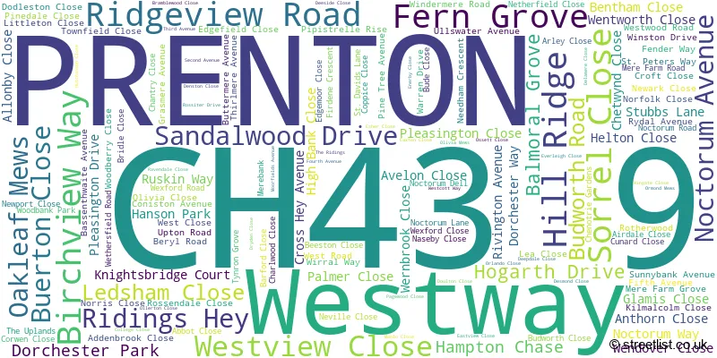
The CH43 9 postal code covers the settlement of PRENTON.
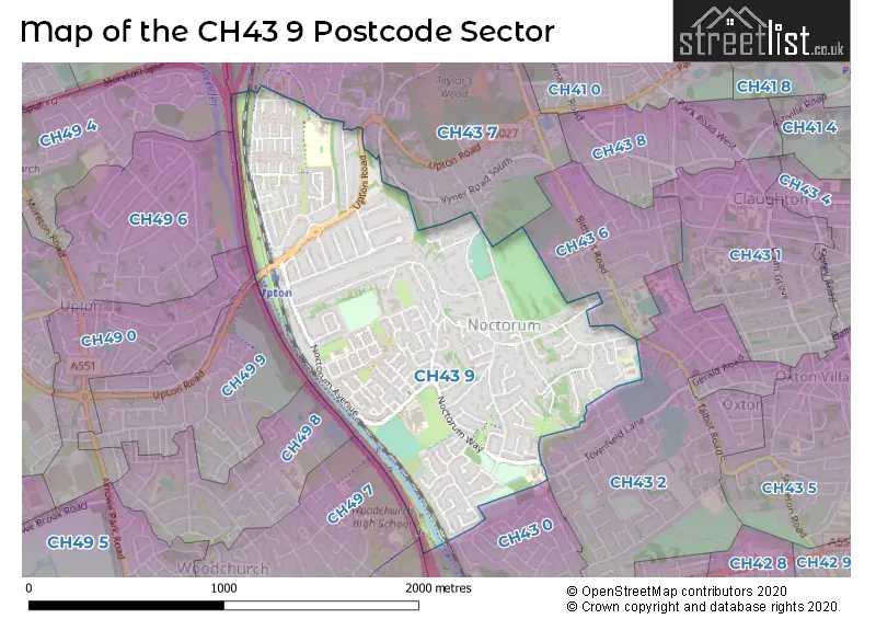
The CH43 9 Postcode shares a border with CH43 6 (PRENTON), CH43 7 (PRENTON), CH49 4 (WIRRAL, Upton), CH49 5 (WIRRAL, Upton), CH49 0 (WIRRAL), CH49 8 (WIRRAL, Upton), CH49 9 (WIRRAL), CH43 0 (PRENTON), CH43 2 (PRENTON), CH49 6 (WIRRAL, Upton) and CH49 7 (WIRRAL, Upton, Woodchurch).
The sector is within the post town of PRENTON.
CH43 9 is a postcode sector within the CH43 postcode district which is within the CH Chester postcode area.
The Royal Mail delivery office for the CH43 9 postal sector is the Prenton Delivery Office.
The area of the CH43 9 postcode sector is 0.95 square miles which is 2.45 square kilometres or 606.00 square acres.
The CH43 9 postcode sector is crossed by the M53 motorway.

Map of the CH43 9 Postcode Sector
Explore the CH43 9 postcode sector by using our free interactive map.
| C | H | 4 | 3 | - | 9 | X | X |
| C | H | 4 | 3 | Space | 9 | Letter | Letter |
Official List of Streets
PRENTON (144 Streets)
Unofficial Streets or Alternative Spellings
Weather Forecast for CH43 9
Press Button to Show Forecast for Noctorum
| Time Period | Icon | Description | Temperature | Rain Probability | Wind |
|---|---|---|---|---|---|
| 12:00 to 15:00 | Partly cloudy (day) | 9.0°C (feels like 7.0°C) | 2.00% | NW 11 mph | |
| 15:00 to 18:00 | Sunny day | 10.0°C (feels like 7.0°C) | 0.00% | NW 11 mph | |
| 18:00 to 21:00 | Partly cloudy (day) | 9.0°C (feels like 7.0°C) | 1.00% | NNW 9 mph | |
| 21:00 to 00:00 | Cloudy | 8.0°C (feels like 6.0°C) | 5.00% | NE 7 mph |
Press Button to Show Forecast for Noctorum
| Time Period | Icon | Description | Temperature | Rain Probability | Wind |
|---|---|---|---|---|---|
| 00:00 to 03:00 | Cloudy | 7.0°C (feels like 4.0°C) | 5.00% | ESE 7 mph | |
| 03:00 to 06:00 | Partly cloudy (night) | 6.0°C (feels like 3.0°C) | 3.00% | E 7 mph | |
| 06:00 to 09:00 | Partly cloudy (day) | 5.0°C (feels like 3.0°C) | 2.00% | E 7 mph | |
| 09:00 to 12:00 | Partly cloudy (day) | 7.0°C (feels like 5.0°C) | 2.00% | E 7 mph | |
| 12:00 to 15:00 | Overcast | 9.0°C (feels like 8.0°C) | 9.00% | NE 4 mph | |
| 15:00 to 18:00 | Cloudy | 10.0°C (feels like 8.0°C) | 10.00% | N 7 mph | |
| 18:00 to 21:00 | Cloudy | 10.0°C (feels like 8.0°C) | 6.00% | NNE 7 mph | |
| 21:00 to 00:00 | Cloudy | 8.0°C (feels like 6.0°C) | 9.00% | ENE 9 mph |
Press Button to Show Forecast for Noctorum
| Time Period | Icon | Description | Temperature | Rain Probability | Wind |
|---|---|---|---|---|---|
| 00:00 to 03:00 | Cloudy | 7.0°C (feels like 4.0°C) | 9.00% | E 9 mph | |
| 03:00 to 06:00 | Cloudy | 6.0°C (feels like 3.0°C) | 9.00% | ESE 9 mph | |
| 06:00 to 09:00 | Cloudy | 6.0°C (feels like 3.0°C) | 8.00% | E 9 mph | |
| 09:00 to 12:00 | Cloudy | 8.0°C (feels like 5.0°C) | 9.00% | E 9 mph | |
| 12:00 to 15:00 | Overcast | 10.0°C (feels like 8.0°C) | 15.00% | ENE 9 mph | |
| 15:00 to 18:00 | Overcast | 11.0°C (feels like 8.0°C) | 20.00% | NE 11 mph | |
| 18:00 to 21:00 | Cloudy | 10.0°C (feels like 8.0°C) | 16.00% | NE 11 mph | |
| 21:00 to 00:00 | Cloudy | 9.0°C (feels like 6.0°C) | 16.00% | NE 11 mph |
Press Button to Show Forecast for Noctorum
| Time Period | Icon | Description | Temperature | Rain Probability | Wind |
|---|---|---|---|---|---|
| 00:00 to 03:00 | Cloudy | 8.0°C (feels like 5.0°C) | 18.00% | NE 11 mph | |
| 03:00 to 06:00 | Cloudy | 8.0°C (feels like 5.0°C) | 17.00% | NE 11 mph | |
| 06:00 to 09:00 | Heavy rain | 8.0°C (feels like 5.0°C) | 68.00% | NE 11 mph | |
| 09:00 to 12:00 | Cloudy | 9.0°C (feels like 6.0°C) | 21.00% | NNE 11 mph | |
| 12:00 to 15:00 | Light rain | 10.0°C (feels like 8.0°C) | 49.00% | NNE 11 mph | |
| 15:00 to 18:00 | Heavy rain shower (day) | 11.0°C (feels like 8.0°C) | 56.00% | N 13 mph | |
| 18:00 to 21:00 | Partly cloudy (day) | 11.0°C (feels like 8.0°C) | 14.00% | N 13 mph | |
| 21:00 to 00:00 | Clear night | 10.0°C (feels like 7.0°C) | 13.00% | WNW 11 mph |
Schools and Places of Education Within the CH43 9 Postcode Sector
Ridgeway High School
Foundation school
Noctorum Avenue, Prenton, Merseyside, CH43 9EB
Head: Mr Gavin Sterry
Ofsted Rating: Requires improvement
Inspection: 2021-09-22 (946 days ago)
Website: Visit Ridgeway High School Website
Phone: 01516783322
Number of Pupils: 873
St Peter's Catholic Primary School
Voluntary aided school
St Peter's Way, Prenton, Merseyside, CH43 9QR
Head: Mrs Sarah Parry
Ofsted Rating: Good
Inspection: 2022-04-08 (748 days ago)
Website: Visit St Peter's Catholic Primary School Website
Phone: 01516778438
Number of Pupils: 191
House Prices in the CH43 9 Postcode Sector
| Type of Property | 2018 Average | 2018 Sales | 2017 Average | 2017 Sales | 2016 Average | 2016 Sales | 2015 Average | 2015 Sales |
|---|---|---|---|---|---|---|---|---|
| Detached | £313,975 | 30 | £374,881 | 34 | £340,661 | 40 | £281,594 | 40 |
| Semi-Detached | £168,995 | 39 | £140,303 | 28 | £147,747 | 32 | £145,704 | 26 |
| Terraced | £96,250 | 14 | £103,773 | 24 | £87,306 | 18 | £97,734 | 17 |
| Flats | £125,500 | 4 | £173,333 | 3 | £108,550 | 5 | £70,225 | 4 |
Important Postcodes CH43 9 in the Postcode Sector
CH43 9EB is the postcode for Ridgeway High School, Noctorum Avenue
CH43 9HG is the postcode for Hillside Primary School, Ridgeview Road
CH43 9QR is the postcode for St. Peters RC Primary School, St. Peters Way
CH43 9QS is the postcode for Fender Way Health Centre, Fender Way
| The CH43 9 Sector is within these Local Authorities |
|
|---|---|
| The CH43 9 Sector is within these Counties |
|
| The CH43 9 Sector is within these Water Company Areas |
|