The CH45 6 postcode sector is within the county of Merseyside.
Did you know? According to the 2021 Census, the CH45 6 postcode sector is home to a bustling 2,424 residents!
Given that each sector allows for 400 unique postcode combinations. Letters C, I, K, M, O and V are not allowed in the last two letters of a postcode. With 52 postcodes already in use, this leaves 348 units available.
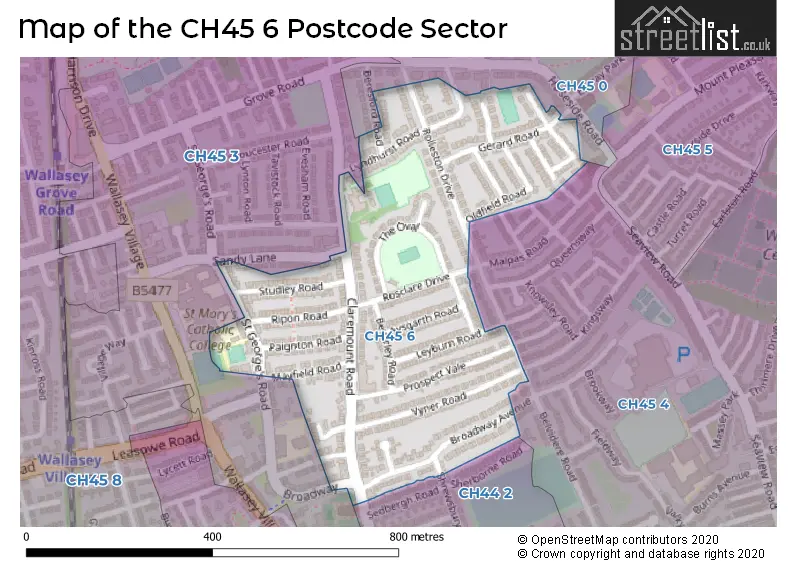
The CH45 6 postal code covers the settlement of WALLASEY.
The CH45 6 Postcode shares a border with CH45 0 (WALLASEY), CH44 2 (WALLASEY), CH45 3 (WALLASEY) and CH45 4 (WALLASEY).
The sector is within the post town of WALLASEY.
CH45 6 is a postcode sector within the CH45 postcode district which is within the CH Chester postcode area.
The Royal Mail delivery office for the CH45 6 postal sector is the Wallasey Delivery Office.
The area of the CH45 6 postcode sector is 0.15 square miles which is 0.38 square kilometres or 93.87 square acres.

Map of the CH45 6 Postcode Sector
Explore the CH45 6 postcode sector by using our free interactive map.
| C | H | 4 | 5 | - | 6 | X | X |
| C | H | 4 | 5 | Space | 6 | Letter | Letter |
Official List of Streets
WALLASEY (30 Streets)
Unofficial Streets or Alternative Spellings
Weather Forecast for CH45 6
Press Button to Show Forecast for Wallasey
| Time Period | Icon | Description | Temperature | Rain Probability | Wind |
|---|---|---|---|---|---|
| 09:00 to 12:00 | Partly cloudy (day) | 9.0°C (feels like 7.0°C) | 1.00% | NNE 7 mph | |
| 12:00 to 15:00 | Cloudy | 10.0°C (feels like 8.0°C) | 4.00% | NNW 9 mph | |
| 15:00 to 18:00 | Sunny day | 11.0°C (feels like 8.0°C) | 1.00% | NW 13 mph | |
| 18:00 to 21:00 | Cloudy | 10.0°C (feels like 8.0°C) | 3.00% | NNW 11 mph | |
| 21:00 to 00:00 | Cloudy | 9.0°C (feels like 8.0°C) | 5.00% | NNW 9 mph |
Press Button to Show Forecast for Wallasey
| Time Period | Icon | Description | Temperature | Rain Probability | Wind |
|---|---|---|---|---|---|
| 00:00 to 03:00 | Overcast | 9.0°C (feels like 8.0°C) | 9.00% | NW 4 mph | |
| 03:00 to 06:00 | Overcast | 8.0°C (feels like 6.0°C) | 10.00% | NNE 7 mph | |
| 06:00 to 09:00 | Cloudy | 7.0°C (feels like 4.0°C) | 7.00% | NNE 9 mph | |
| 09:00 to 12:00 | Cloudy | 8.0°C (feels like 6.0°C) | 8.00% | NNE 9 mph | |
| 12:00 to 15:00 | Cloudy | 9.0°C (feels like 7.0°C) | 6.00% | NNW 11 mph | |
| 15:00 to 18:00 | Cloudy | 9.0°C (feels like 7.0°C) | 6.00% | NNW 11 mph | |
| 18:00 to 21:00 | Cloudy | 9.0°C (feels like 7.0°C) | 6.00% | N 11 mph | |
| 21:00 to 00:00 | Clear night | 8.0°C (feels like 5.0°C) | 2.00% | N 9 mph |
Press Button to Show Forecast for Wallasey
| Time Period | Icon | Description | Temperature | Rain Probability | Wind |
|---|---|---|---|---|---|
| 00:00 to 03:00 | Clear night | 6.0°C (feels like 4.0°C) | 5.00% | NNE 9 mph | |
| 03:00 to 06:00 | Cloudy | 6.0°C (feels like 3.0°C) | 8.00% | NNE 9 mph | |
| 06:00 to 09:00 | Cloudy | 6.0°C (feels like 3.0°C) | 6.00% | NNE 9 mph | |
| 09:00 to 12:00 | Partly cloudy (day) | 7.0°C (feels like 5.0°C) | 4.00% | NNE 9 mph | |
| 12:00 to 15:00 | Cloudy | 9.0°C (feels like 7.0°C) | 8.00% | NW 9 mph | |
| 15:00 to 18:00 | Overcast | 10.0°C (feels like 7.0°C) | 10.00% | NNW 9 mph | |
| 18:00 to 21:00 | Cloudy | 9.0°C (feels like 7.0°C) | 8.00% | N 9 mph | |
| 21:00 to 00:00 | Cloudy | 8.0°C (feels like 7.0°C) | 9.00% | NE 7 mph |
Press Button to Show Forecast for Wallasey
| Time Period | Icon | Description | Temperature | Rain Probability | Wind |
|---|---|---|---|---|---|
| 00:00 to 03:00 | Partly cloudy (night) | 8.0°C (feels like 6.0°C) | 6.00% | ESE 7 mph | |
| 03:00 to 06:00 | Cloudy | 7.0°C (feels like 5.0°C) | 9.00% | ESE 7 mph | |
| 06:00 to 09:00 | Cloudy | 7.0°C (feels like 4.0°C) | 9.00% | S 9 mph | |
| 09:00 to 12:00 | Cloudy | 8.0°C (feels like 7.0°C) | 11.00% | WNW 9 mph | |
| 12:00 to 15:00 | Cloudy | 10.0°C (feels like 8.0°C) | 13.00% | NNW 9 mph | |
| 15:00 to 18:00 | Cloudy | 10.0°C (feels like 8.0°C) | 15.00% | NNW 9 mph | |
| 18:00 to 21:00 | Cloudy | 10.0°C (feels like 8.0°C) | 13.00% | N 9 mph | |
| 21:00 to 00:00 | Cloudy | 9.0°C (feels like 7.0°C) | 14.00% | N 9 mph |
House Prices in the CH45 6 Postcode Sector
| Type of Property | 2018 Average | 2018 Sales | 2017 Average | 2017 Sales | 2016 Average | 2016 Sales | 2015 Average | 2015 Sales |
|---|---|---|---|---|---|---|---|---|
| Detached | £361,750 | 4 | £295,600 | 5 | £285,000 | 3 | £247,158 | 6 |
| Semi-Detached | £248,432 | 30 | £204,394 | 26 | £191,952 | 25 | £197,634 | 37 |
| Terraced | £216,500 | 2 | £187,500 | 2 | £245,000 | 1 | £168,317 | 3 |
| Flats | £70,992 | 6 | £73,750 | 7 | £54,875 | 4 | £54,395 | 10 |
Important Postcodes CH45 6 in the Postcode Sector
CH45 6UE is the postcode for St. Georges Primary School, Claremount Road
| The CH45 6 Sector is within these Local Authorities |
|
|---|---|
| The CH45 6 Sector is within these Counties |
|
| The CH45 6 Sector is within these Water Company Areas |
|