The CH49 5 postcode sector is within the county of Merseyside.
Did you know? According to the 2021 Census, the CH49 5 postcode sector is home to a bustling 1,478 residents!
Given that each sector allows for 400 unique postcode combinations. Letters C, I, K, M, O and V are not allowed in the last two letters of a postcode. With 49 postcodes already in use, this leaves 351 units available.
The largest settlements in the CH49 5 postal code are WIRRAL and Upton.
The CH49 5 Postcode shares a border with CH49 1 (WIRRAL, Upton, Greasby), CH61 7 (WIRRAL, Thingwall, Heswall), CH49 0 (WIRRAL), CH49 8 (WIRRAL, Upton), CH61 3 (WIRRAL, Irby, Thingwall), CH43 0 (PRENTON), CH43 3 (PRENTON, North Cheshire Trading Estate), CH43 9 (PRENTON), CH49 3 (WIRRAL, Greasby) and CH49 7 (WIRRAL, Upton, Woodchurch).
The sector is within the post town of WIRRAL.
CH49 5 is a postcode sector within the CH49 postcode district which is within the CH Chester postcode area.
The Royal Mail delivery office for the CH49 5 postal sector is the Upton (ch) Delivery Office.
The area of the CH49 5 postcode sector is 1.40 square miles which is 3.63 square kilometres or 896.96 square acres.
The CH49 5 postcode sector is crossed by the M53 motorway.

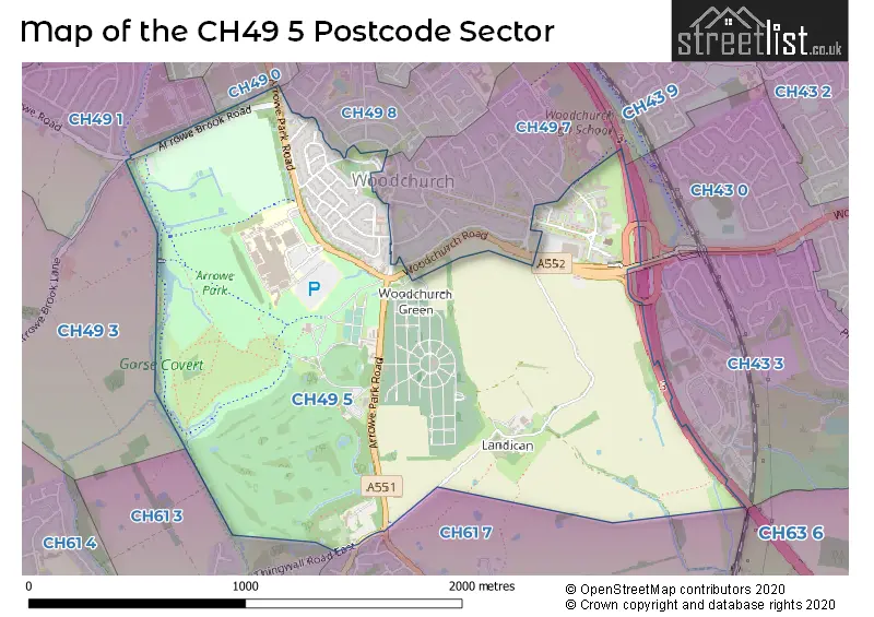
Map of the CH49 5 Postcode Sector
Explore the CH49 5 postcode sector by using our free interactive map.
| C | H | 4 | 9 | - | 5 | X | X |
| C | H | 4 | 9 | Space | 5 | Letter | Letter |
Official List of Streets
Upton (4 Streets)
WIRRAL (18 Streets)
Unofficial Streets or Alternative Spellings
Upton
ARROWE BROOK ROAD CHURCH LANE WOODLAND ROADHeswall
BARNSTON ROAD PENSBY ROADWIRRAL
ARROWE BROOK LANE ARROWE ROAD MEADOW CRESCENT THINGWALL ROAD EAST CHAMPIONS BUSINESS PARK COMMON FIELD ROAD FLEET CROFT ROAD HESWALL ISLAND LANDICAN ROAD NCR56 SMITHY BROOK DRIVE YEWTREE CLOSEHigher Bebington
LANDICAN LANEWoodchurch
ACKERS ROADWeather Forecast for CH49 5
Press Button to Show Forecast for Thingwall
| Time Period | Icon | Description | Temperature | Rain Probability | Wind |
|---|---|---|---|---|---|
| 21:00 to 00:00 | Cloudy | 8.0°C (feels like 7.0°C) | 4.00% | N 7 mph |
Press Button to Show Forecast for Thingwall
| Time Period | Icon | Description | Temperature | Rain Probability | Wind |
|---|---|---|---|---|---|
| 00:00 to 03:00 | Clear night | 7.0°C (feels like 5.0°C) | 0.00% | ESE 7 mph | |
| 03:00 to 06:00 | Partly cloudy (night) | 5.0°C (feels like 3.0°C) | 1.00% | SE 7 mph | |
| 06:00 to 09:00 | Cloudy | 6.0°C (feels like 4.0°C) | 4.00% | SSE 4 mph | |
| 09:00 to 12:00 | Cloudy | 9.0°C (feels like 8.0°C) | 4.00% | SSE 4 mph | |
| 12:00 to 15:00 | Partly cloudy (day) | 11.0°C (feels like 9.0°C) | 0.00% | NNW 7 mph | |
| 15:00 to 18:00 | Sunny day | 11.0°C (feels like 9.0°C) | 0.00% | NW 9 mph | |
| 18:00 to 21:00 | Partly cloudy (day) | 10.0°C (feels like 8.0°C) | 1.00% | NNW 7 mph | |
| 21:00 to 00:00 | Cloudy | 8.0°C (feels like 7.0°C) | 4.00% | NW 4 mph |
Press Button to Show Forecast for Thingwall
| Time Period | Icon | Description | Temperature | Rain Probability | Wind |
|---|---|---|---|---|---|
| 00:00 to 03:00 | Partly cloudy (night) | 8.0°C (feels like 6.0°C) | 1.00% | NW 4 mph | |
| 03:00 to 06:00 | Partly cloudy (night) | 7.0°C (feels like 5.0°C) | 2.00% | SW 4 mph | |
| 06:00 to 09:00 | Cloudy | 7.0°C (feels like 6.0°C) | 5.00% | N 4 mph | |
| 09:00 to 12:00 | Cloudy | 9.0°C (feels like 8.0°C) | 5.00% | NE 7 mph | |
| 12:00 to 15:00 | Cloudy | 11.0°C (feels like 9.0°C) | 4.00% | NE 7 mph | |
| 15:00 to 18:00 | Cloudy | 11.0°C (feels like 10.0°C) | 5.00% | NNE 7 mph | |
| 18:00 to 21:00 | Cloudy | 11.0°C (feels like 10.0°C) | 5.00% | NNE 7 mph | |
| 21:00 to 00:00 | Cloudy | 9.0°C (feels like 8.0°C) | 5.00% | NE 7 mph |
Press Button to Show Forecast for Thingwall
| Time Period | Icon | Description | Temperature | Rain Probability | Wind |
|---|---|---|---|---|---|
| 00:00 to 03:00 | Overcast | 7.0°C (feels like 5.0°C) | 11.00% | E 7 mph | |
| 03:00 to 06:00 | Overcast | 7.0°C (feels like 5.0°C) | 10.00% | SSE 7 mph | |
| 06:00 to 09:00 | Overcast | 7.0°C (feels like 5.0°C) | 13.00% | S 7 mph | |
| 09:00 to 12:00 | Overcast | 8.0°C (feels like 6.0°C) | 14.00% | SSW 7 mph | |
| 12:00 to 15:00 | Cloudy | 10.0°C (feels like 8.0°C) | 13.00% | NE 7 mph | |
| 15:00 to 18:00 | Cloudy | 10.0°C (feels like 8.0°C) | 12.00% | NE 9 mph | |
| 18:00 to 21:00 | Cloudy | 10.0°C (feels like 8.0°C) | 11.00% | NNE 9 mph | |
| 21:00 to 00:00 | Cloudy | 9.0°C (feels like 7.0°C) | 10.00% | NNE 7 mph |
Press Button to Show Forecast for Thingwall
| Time Period | Icon | Description | Temperature | Rain Probability | Wind |
|---|---|---|---|---|---|
| 00:00 to 03:00 | Cloudy | 8.0°C (feels like 7.0°C) | 8.00% | ENE 7 mph | |
| 03:00 to 06:00 | Cloudy | 8.0°C (feels like 7.0°C) | 9.00% | ESE 7 mph | |
| 06:00 to 09:00 | Cloudy | 8.0°C (feels like 6.0°C) | 7.00% | NE 7 mph | |
| 09:00 to 12:00 | Partly cloudy (day) | 9.0°C (feels like 8.0°C) | 4.00% | NE 7 mph | |
| 12:00 to 15:00 | Cloudy | 11.0°C (feels like 9.0°C) | 6.00% | NNE 9 mph | |
| 15:00 to 18:00 | Cloudy | 12.0°C (feels like 10.0°C) | 9.00% | N 11 mph | |
| 18:00 to 21:00 | Partly cloudy (day) | 11.0°C (feels like 9.0°C) | 3.00% | NNW 11 mph | |
| 21:00 to 00:00 | Cloudy | 9.0°C (feels like 7.0°C) | 5.00% | N 9 mph |
Schools and Places of Education Within the CH49 5 Postcode Sector
Foxfield School
Community special school
New Hey Road, Woodchurch, Merseyside, CH49 5LF
Head: Mr Martin McKenna
Ofsted Rating: Good
Inspection: 2023-02-08 (436 days ago)
Website: Visit Foxfield School Website
Phone: 01516418810
Number of Pupils: 174
Meadowside School
Community special school
Pool Lane, Wirral, Merseyside, CH49 5LA
Head: Miss Paula Wareing
Ofsted Rating: Requires improvement
Inspection: 2022-05-25 (695 days ago)
Website: Visit Meadowside School Website
Phone: 01516787711
Number of Pupils: 104
St Michael and All Angels Catholic Primary School
Voluntary aided school
New Hey Road, Wirral, Merseyside, CH49 5LE
Head: Mrs Susan Ralph
Ofsted Rating: Good
Inspection: 2021-06-24 (1030 days ago)
Website: Visit St Michael and All Angels Catholic Primary School Website
Phone: 01516774088
Number of Pupils: 232
House Prices in the CH49 5 Postcode Sector
| Type of Property | 2018 Average | 2018 Sales | 2017 Average | 2017 Sales | 2016 Average | 2016 Sales | 2015 Average | 2015 Sales |
|---|---|---|---|---|---|---|---|---|
| Detached | £202,000 | 4 | £186,500 | 3 | £190,000 | 1 | £166,650 | 3 |
| Semi-Detached | £157,461 | 14 | £162,563 | 8 | £151,867 | 15 | £143,262 | 17 |
| Terraced | £126,817 | 3 | £116,500 | 2 | £90,875 | 4 | £77,225 | 4 |
| Flats | £70,567 | 6 | £73,613 | 4 | £70,645 | 10 | £74,100 | 5 |
Important Postcodes CH49 5 in the Postcode Sector
CH49 5LA is the postcode for Meadowside School, Pool Lane
CH49 5LE is the postcode for St Michaels And All Angels R C Primary School, New Hey Road, St. Michaels & All Angels RC Infant School, New Hey Road, and Foxfield School, New Hey Road
CH49 5PE is the postcode for Wirral University Teaching Hospital N H S Foundation Trust, Arrowe Park Hospital, Arrowe Park Road, MAIN BLOCK ARROWE PARK HOSPITAL, Wirral University Teaching Hospital N H S Foundation Trust, Arrowe Park Hospital, Arrowe Park Road, and MATERNITY BLOCK ARROWE PARK HOSPITAL, Wirral University Teaching Hospital N H S Foundation Trust, Arrowe Park Hospital, Arrowe Park Road
CH49 5PL is the postcode for The Warrens Medical Centre, Arrowe Park Road
| The CH49 5 Sector is within these Local Authorities |
|
|---|---|
| The CH49 5 Sector is within these Counties |
|
| The CH49 5 Sector is within these Water Company Areas |
|